Archive for the ‘Trail Access’ Category

Santa Clarita Valley Trail Users Update

Tuesday, August 30th, 2011

Dear Friends,

We are reaching out to all of you who signed the petition supporting equal access for all trail users, including cyclists, on the Canyon Trail at the Placerita Nature Center.  Here’s an update.

About 25 of us met with three park officials from LA County Parks and Rec on August 19 to express our outrage about the recent closing of the Canyon Trail to cyclists.  At this meeting, the County officials explained that the previous signs allowing cycling on this trail were a “mistake” and also cited environmental and safety concerns relating to off-road cycling on this trail.  However, the County officials admitted that this is a matter of policy and that policy can be changed.  Kimel Conway, the senior official present at the meeting, agreed to schedule a meeting with Russ Guiney, the Director of LA County Parks and Rec, if we would prepare a “brief” summarizing our concerns and the possible solutions to their concerns.

Since then, we have formed a committee to press on with our cause.  Here’s what the committee has resolved thus far.

1.  We have prepared a “brief” as requested by the County in preparation for our meeting with the Director.  We are now working on scheduling that meeting at the earliest possible time.

2.  We recognize that the issue is much bigger than the Canyon Trail at the Placerita Nature Center.  Recently the trails at Vasquez Rocks were also closed by the County for much the same reasons.  We need to advocate for safe and equal access to ALL SCV TRAILS.

3.  We believe our best position is to advocate for safe and equal access for ALL USERS, not just cyclists.  Even though others in our community want to exclude cyclists from the trials, we believe an inclusive position is most likely to succeed.

4.  We have named our group the SCV Trail Users and will use the slogan, “Safe and Equal Access for All”.

5.  We need to build a database of supporters as we will likely need to mobilize larger numbers at future public hearings.  We will be using our Facebook Group, The SCV Trail Users – Safe & Equal Access To SCV Trails, our current petition, and this email list for this purpose.

6.  We will be designing and distributing a flyer and a business card (to carry with you when out on the trails) with information about the Facebook Group, the petition, and our email list.  We plan to make the flyers available at all of the local bike shops.

What can you do to help?

Please help us build our database of supporters.   We believe this will be critical to our success!  Join our Facebook group, sign our petition, and add your name to our email list.  Please ask other supporters to do the same.  And be ready to show your support!

Facebook Group:  http://www.facebook.com/groups/saveplaceritatrail/

Petition:  http://www.ipetitions.com/petition/canyon_trail_mtb_access/

Email SCVTrailUsers@gmail.com to add an email address to our list.

Canyon Trail Closure in Placerita Canyon Nature Center

Monday, August 29th, 2011

The Canyon trail winds its way for 1.85 miles along Placerita Creek between Walker Ranch and the Placerita Canyon Nature Center. It makes a great loop with the Santa Clara Truck Trail and Los Pinetos. For many years cyclists have been riding this great loop, and it is a local favorite. It is one of very few beginner- and kid-friendly trails in the Santa Clarita Valley.

In July 2011 the trail was posted closed to bikes with no public notice, warning or input. Law enforcement have been on hand to ticket cyclists who ignore the signs, or didn’t notice them.

The alternative return route after riding Los Pinetos  is to ride pavement from Walker Ranch out to the Nature Center and back to the usual parking area. This paved, narrow two-lane road has no shoulder and no bike lanes, and is much more dangerous.  There is no alternative easy out-and-back off-road ride for beginners or those looking for an easy ride.

In County Nature Preserves like Placerita Canyon, it is at the sole discretion of the director whether trails are opened or closed to bikes. Local riders have been in contact with the park’s management about the closure, and are working to find solutions to mitigate the concerns that have led to the closure of the trail to bikes.

While it is encouraging to know the County is open to hearing the concerns of local trail users who are directly affected by this closure, to have received no prior official or public notice of the closure has left the local cycling community frustrated and angered. The reasons for the closure were unclear, though environmental impacts to Placerita Creek were initially mentioned. However the trail remains open to equestrians who have much more impact than bicycles. Trail user conflicts seem to be the real reason, though to our knowledge no specific injuries or instances have been cited. 

CORBA has long argued that excluding a user group from a trail only leads to further division among user groups, whereas including all users helps bring the trail user community together to find solutions. As the local cycling community works with the County to find a reasonable compromise to re-open the trail, cyclists should avoid riding the Canyon Trail and obey all posted signs in the area.

Read more of the local perspective from the RightOnSCV.com blog or coverage from The Signal.


Tapia Spur Trail to Undergo Shared-Use Upgrades Starting in September

Thursday, June 30th, 2011

State Parks has announced that the multi-use Tapia Spur Trail in Malibu Creek State Park/Tapia Park will undergo several changes to address the trail’s ability to sustain shared use by hikers, equestrians, and mountain bikers. The work is tentatively set to begin in September of 2011.

According to State Parks’ Tapia Spur Trail project description (Tapia Spur Trail Muli-Use Work Project Report – PDF), dated April 12, 2011, Tapia Spur Trail lacks a variety of components necessary to adequately accommodate multi-use moving forward based on new multi-use guidelines, and therefore intends to implement several multi-use components that will bring the trail up to current multi-use guidelines. These components include brushing (which has already begun), improved drainage and increased tread width, speed control sections in areas lacking sight distance, and realignment of one stretch of trail  to increase sight distance and redirect the trail off the fall line.

Of particular interest to CORBA are the components of “sinuosity” (the trail weaving in and out of the topography to create a curvy alignment) and “pinch points” (placement of items such as rocks or logs that create a perceived narrow point in the trail corridor). Both of these components have been used in other areas with good results; that of slowing the mountain biker while maintaining an enjoyable experience for the cyclist, hiker, and equestrian. As I have previously stated, slowing down around other trail users can virtually eliminate the complaints by those who say that mountain bikes are dangerous because they go too fast. While most cyclists are in control of their bikes when passing other trail users, the perception of speed–even a few miles per hour–can reduce or even spoil another user’s trail experience, including other mountain bikers. We’re all out there for the same reason, to enjoy nature. Treating others with respect is part of that enjoyment.

CORBA is encouraged by this upgrade project as it will allow State Parks to work more closely with the trail user community in implementing shared use concepts and guidelines. Tapia Spur Trail can become a showcase of proper multi-use practices, and with the assistance and cooperation of the mountain bike community, we can potentially have a comprehensive example of multi-use guideline implementation. CORBA has been assured that mountain bikers will be considered in every step of component implementation on this important trail link from Malibu Creek State Park to Tapia Park.

I’d like to take this opportunity to remind the mountain bike community that CORBA’s funding and volunteer needs are ongoing. Trail work volunteers are still needed, as well as funding for CORBA Trail Crew tools and other supplies. Just recently State Parks released a comprehensive trail crew leader training schedule, and in addition to trail workers, we also need those interested in becoming trained and certified as trail crew leaders. Training starts July 7 so we need volunteers immediately. To contact CORBA, email advocacy@corbamtb.com, and go to our Join/Donate page to to help support CORBA’s efforts.

All Fun at June 18th CORBA Beginner Ride

Monday, June 20th, 2011


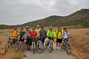
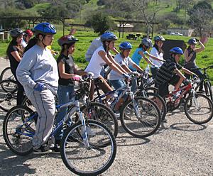
Nine beginners at Sycamore Canyon (Point Mugu State Park)

Nine mountain bikers turned up for CORBA’s Beginner Ride in Sycamore Canyon (Rancho Sierra Vista/Point Mugu State Park). We started our ride on nice double track leading through the meadows of the National Park Service property of Rancho Sierra Vista. Once at the top of famous Blacktop Hill we took a moment to talk about safety of descending the hill: Watch ahead for gravel on the corners, control speed (max 15 mph), slow down for other trail users, perhaps say “Hello” and last but not least… have fun!

Once down the hill we turned west onto Ranch Center Road, unfortunately passing by the fun side route known as Art’s Trail, which was closed a year ago due to archeological concerns (read here about Art’s trail). After some climbing on the paved road … our reward. Wood Canyon fire road and two great single tracks, Two Foxes and Sin Nombre. I think I speak for all of us when I say we had a great time! No one even complained that we had to finish our ride with a final climb back up Blacktop to  Rancho Sierra Vista. Not only that, they smiled! Just check out the picture.

14 miles, 1300 feet of climbing, all smiles!


The 14-mile ride took us about three hours and had 1,300 feet of climbing, and by all accounts was pure fun!

I would like to thank everyone for joining the CORBA/North Ranch Mountain Bikers Beginner Ride. Check out the pictures.

Hope to see you on my next ride! Visit CORBA calendar and see you on the trails!

– Danusia Bennett-Taber

Third Public Meeting for Topanga State Park General Plan on June 14th

Tuesday, May 24th, 2011

California State Parks is inviting the public to the third public meeting for the Topanga State Park General Plan. The purpose of this meeting is to present the single (preferred) plan and support materials. After the presentation, the General Plan team, comprised of CSP landscape architects environmental scientists, historians, archaeologists and park staff will be available to discuss this preferred plan. The single plan was developed with the input received at the first and second public meetings held in September 2009 and July 2010.

Following the third public meeting, the General Plan team will prepare the preliminary General Plan which will then be available for public review and comment as per the California Environmental Quality Act (CEQA) process.

After the completion of the CEQA process, the General Plan Document will be presented to the California Parks and Recreation Commission which will entail a public hearing process including additional opportunity for public comment.

A General Plan is mandated for state parks units by the Public Resources Code. The plan becomes the primary management document for a unit of the State Park System, establishing its purpose and management direction for the future. The plan does not provide specific physical designs but does provide a vision for the park and guidelines for future development.

Meeting location:

June 14, 2011 (Tuesday)

6:30 pm to 8:00 pm

Stewart Hall @ Temescal Gateway Park

Sunset Blvd. & Temescal Canyon Road

Pacific Palisades

Topanga State Park General Plan Meeting #3

Friday, June 3rd, 2011

California State Parks is holding its third public meeting to determine the new general plan for Topanga State Park on June 14 at Temescal Gateway Park in Pacific Palisades. Mountain bikers who use Topanga State Park and surrounding trails in the Santa Monica Mountains National Recreation area are strongly encouraged to attend the meeting and comment on the plan. For details click here Scan 4.

CORBA/IMBA Affiliation Update

Wednesday, June 1st, 2011

A few months ago we told you about our decision to partner with the International Mountain Bicycle Association’s (IMBA) chapter program. The process is complete, and we are happy to announce that the transition is going very well. However, there are still a few things that were unforeseen, one of them being the renewal process.

Many CORBA members have recently received a renewal notice from IMBA, which may be confusing. This is because your CORBA membership automatically became an IMBA membership when we made the transition. No problem! Simply renew your new IMBA membership and select CORBA as your local chapter each time you renew. From now on when you renew, you will renew both your IMBA and CORBA membership at the same time, with everything being handled by IMBA. If renewing by telephone, please make sure to indicate CORBA as your local chapter.

We encourage you to continue to make donations directly to CORBA to help support our local efforts of advocacy, trail building and maintenance, free monthly mountain bike skills classes, Youth Adventures at-risk youth outings, Kids Club, and our web site www.corbamtb.com. CORBA still receives a percentage of membership dues though through this affiliation with IMBA, but dues alone can not support our programs entirely. Our Trail Crew requires annual tool purchases, and Youth Adventures is in constant need of bikes, parts, and helmets, as well as snacks for participants because many of these kids can not even afford a granola bar for themselves or come to the outing without having had breakfast. Other costs include licensing and insurance for our trailers and ride programs. It adds up! Click here to go directly to our donation page. http://www.corbamtb.com/join/donate.shtml Thank you for your support in helping us keep trails open to bicycles!

Angeles National Forest Trails to Open May 16, 2011

Friday, May 13th, 2011

The two questions we have been asked more than any other recently: “which trails are closed in the Angeles National Forest?  and “which trails are open in the Angeles National Forest?”

According to the Forest Service map of the station fire closure area at http://maps.fs.fed.us/stationfire/ the list below shows the status, effective May 16 2011, of some of the more popular trails that were affected by the Station Fire. Keep in mind that even though these trails are in the newly opened areas of the forest, the individual trails may be signed closed.  Please respect any trail closure signs and stay off those trails for your own safety and the recovery of the forest.

Many of the trails will not be in good shape, so be prepared for surprises like downed trees, slides, washouts, ruts, and other hazards. Many trails have been drastically changed from before the Station Fire. Many fire roads have not yet been graded and may be much narrower and in very poor condition with ruts and washouts. All the usual caveats about trail safety apply so use the trails safely and responsibly, and be especially careful the first time you travel on one of the newly opened trails.

Opened Trails (As of May 16, 2011 – Updated July 31, 2011) – 

  • Brown Mountain (to the saddle)
  • El Prieto
  • Gabrielino (JPL to Paul Little)
  • Gabrielino (Switzers to Redbox to Chantry)
  • Bear Canyon Trail
  • Sam Merrill Trail
  • Castle Canyon Trail
  • Sunset Ridge Trail
  • Mt. Lowe West Trail
  • Idlehour Trail
  • Kenyon Devore Trail
  • Rim Trail
  • Sturtevant Trail
  • Santa Clara Divide Truck Trail (Dillon Divide to Mt. Gleason to Three Points – non-motorized only)
  • Chilao Loop/Mt. Hillyer
  • Silver Mocassin
  • Shortcut
  • Valley forge
  • Mt. Lukens road (once the highway opens)
  • Earl Canyon
  • Haines Canyon
  • Mt Lukens Fire Road (as of June 3 opening of Angeles Crest Highway)
  • Graveyard Truck Trail
  • Grizzly Flat Fire Road
  • Doc Larsen
  • Everything east of Chilao

Keep in mind that even though these trails are in the opened area, the individual trails may be signed closed (And those signs mustl be respected). Many of the trails will not be in good shape, so be prepared for surprises like downed trees, massive ruts or slides, washouts, and other hazards.

Closed Trails (Until Further Notice)

  • Strawberry Peak
  • Tom Sloan
  • Dawn Mine
  • Millard Falls
  • Upper Brown Mountain (Saddle to the Summit/Ken Burton)
  • Ken Burton
  • Gabrielino from Switzers to Paul Little
  • Hoyt
  • Stone Canyon
  • Crescenta View
  • Rim of the Valley
  • Condor Peak Trail
  • Trail Canyon
  • Alder Creek
  • Colby Canyon
  • Josephine
  • Mueller Tunnel
  • Vetter Mountain

In addition to the above a separate closure remains in effect for the Williamson Rock area  (Closure Map is available).

Angeles National Forest Opens Some Trails

Friday, May 13th, 2011

News Release
USDA Forest Service
Angeles National Forest

May 12, 2011
ANF-06-2011 Angeles National Forest
701 N. Santa Anita Ave.
Arcadia, CA 91006
www.fs.fed.us/r5/angeles
FOR IMMEDIATE RELEASE
Contact: Sherry Rollman or
John D. Wagner at (626) 574-5208

Angeles National Forest Reopens About Half of Closed Areas

ARCADIA, Calif.—In a major step forward, effective May 16, the Angeles National Forest will reopen about half of the areas that have been closed due to the Station Fire.

The reopening of about 98,000 acres in the Forest’s northern, southern and eastern areas will offer the public recreational opportunities including hiking, picnicking and camping in time for the Memorial Day weekend.

Over 100 miles of hiking trails are being reopened as well as popular campgrounds. Specific areas include Indian Canyon Trailhead, Charlton Flat Picnic Area, Gould Mesa Campground, Bear Canyon Trail, Paul Little Picnic Area, Mill Creek Summit Picnic Area, Silver Moccasin Trail, Nature’s Canteen Trail, Sunset Ridge Trail, and the entire San Gabriel Wilderness area. The portion of the Pacific Crest Trail that runs through the Forest will reopen as well, with some minor reroutes.

The reopening is the result of a recovery strategy that includes community volunteers and partner organizations working alongside the Forest Service to remove invasive weeds, help plant trees, and restore trails so the public can once again access some of the areas impacted. Their support and involvement has allowed the Forest to implement repairs and reopen these areas in a manner that addresses public safety and ecological recovery.

The remaining portion of the burned area that is primarily within Big Tujunga Canyon will remain closed until further notice, as it requires additional recovery time. This area was recently designated a “Treasured Landscape” by the National Forest Foundation and efforts are underway to allow for species recovery and implementing sustainable recreational opportunities.

Please visit the Angeles National Forest website for a map of the areas now open.

Voice Your Support of Trails TODAY!

Thursday, May 12th, 2011
FROM THE CALIFORNIA BICYCLE COALITION:

Our partners at America Bikes just found out late last night that the U.S. Senate’s Environment and Public Works Committee is deciding what goes into the next federal transportation bill today and tomorrow.

We need every advocate in California to take action TODAY!

If we don’t act now, dedicated funding for biking and walking programs may be written out of our transportation system for the next six years.

Senator Barbara Boxer is the chair of this committee and we need you to get word to her in every way and medium possible TODAY that we’re counting on her continued support for dedicated funding for biking and walking.

In every media interview related to Bike to Work Week, please be sure to thank the Senator for her continued support for dedicated funding for biking and walking, specifically Transportation Enhancements, Safe Routes to School and the Recreational Trails Program.

In addition, we ask that you alert all your members and supporters as soon as possible, urging them to call the Senator’s office today. Please use the message below.

Our apologies for hitting you on a day when you’re already very busy, but we just learned of this after 10 p.m. last night and with all the media being generated about Bike to Work Week this is a great opportunity for maximum impact. Again, we can’t stress the urgency enough: To preserve dedicated funding for biking and walking in next transportation bill we need California to get Sen. Boxer to take action today.

If you have any questions, please don’t hesitate to contact me at (916) 446-7558 or dave@calbike.org.

Dave Snyder

Relaunch Director/CEO

_________________________________________________________________________

Senator Barbara Boxer needs to hear from you RIGHT NOW.

The committee she leads in the US Senate, the Environment and Public Works Committee, is deciding what goes into the very important federal transportation bill today and tomorrow. She needs to know that we want her to fight for bicycling and walking programs like Transportation Enhancements (the federal funding sources that helps pay for bicycling and walking facilities and programs throughout California), Safe Routes to School and the Recreational Trails program.

If we don’t act now, bicycling and walking programs may be written out of our transportation system for the next six years.

At this very moment, she is negotiating with other senators who don’t think bicycling and walking are an important part of the transportation bill. She needs to know that we have her back on this issue and she shouldn’t give up on these crucial programs.

Call Senator Boxer right now and tell her:

“I am one of your constituents and I think bicycling and walking need to be a part of the transportation bill. Please ensure that Transportation Enhancements, Safe Routes to School and the Recreational Trails program continue with strong and dedicated funding as they are today.”

Calls to DC are best. Her Washington, DC office number: (202) 224-3553. If it’s busy and you’re short for time, here’s her LA office number: (213) 894-5000.