Posts Tagged ‘castaic’

Castaic Multi-Use Trail Master Plan Meeting #2

Friday, September 18th, 2015

20150917001-Castaic Trail Master Plan-1
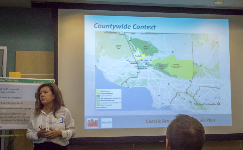
Last night, September 17, 2015, LA County held the second in the series of planning meetings announced last month. Last night’s meeting was well-attended by mountain bikers, but also by local residents who are concerned about trails and fire roads through their properties at Tapia Canyon and other locations within the study area.

It was made clear at the meeting’s outset that the County trails policy is multi-use, and that nothing in this process takes away any property owners’ rights. Just because a trail is drawn somewhere on this plan doesn’t mean it will be constructed exactly where it is drawn, or that it will be constructed at all. It will guide the County’s planning efforts for future growth.

Disrespectful and illegal behavior by a small non-representative group of riders has tarnished the image of mountain bikers in the area, while at the other end of the spectrum the NICA SoCal League teams in the area have done an outstanding job of representing our sport responsibly.

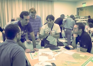
About 50 people gathered around four tables packed with maps to point out where there are important existing trails, brainstorm on where they’d like to see new connections and access points, and what types of features they’d like to see at a bike skills park. Property owners pointed out where their properties are on the map, and expressed valid concerns about trails that pass through their properties.

12047030_10206819759845884_4543868626721243399_n-1
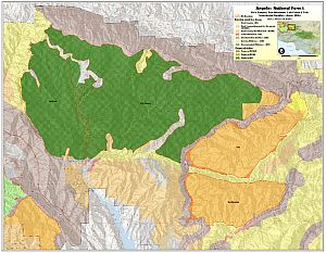
Some important issues came up, such as the preservation of iconic and unique trails in the Tapia Canyon area, access to Forest Service and Tapia Canyon blocked by the Tesoro development, and potential impacts of the Hidden Ranch at Tapia Canyon Development. It is these and other development proposals that have prompted the County to take on this important planning task. There are more people coming to the Castaic area, more homes, more business, more kids on bikes and more demand for recreational trails.

For example, there’s strong demand for a regional-quality bike park facility at Grasshopper Canyon in the Castaic Lake State Recreation Area, as proposed by CORBA some time ago. We’d like to go big, including tot, beginner, intermediate and advanced pump tracks, progressive dirt jumps, a downhill flow trail, a permanent cyclocross/XC  training and racing track, dual slalom tracks, four-cross course, progressive dirt jumps and skills areas. We’d also like to see smaller community pump tracks at easily-accessible locations through the area.

Among the other items being discussed were:

  • A long-distance, multi-use trail around Castaic Lake including access to secluded bays and beaches.
  • Trail connections from the Sports Complex to Castaic Lake SRA and to Charlie and Wayside canyons.
  • Easier access to Tapia Canyon trails through the Tesoro development
  • Continued access to Tapia via Wayside/Junkyard through the Hidden Ranch at Tapia development.
  • Connections to Forest Service trails and fire roads
  • Connections to Ventura County and Los Padres NF trails
  • Preservation of iconic and unique Tapia trails such as Dog Tag, G-Out and others.

What else would you like to add? You can still let them know.

Make Your Comments Online at http://castaicmultiusetrails.org

The County understands that many people are unable to attend public meetings, or need more than just a meeting to consider their needs. An online Interactive Map allows members of the public to draw in where they’d like to see trails, bike park facilities or trailhead facilities such as parking, bathrooms and water fountains. This new planning tool also allows the public to upload gps tracks of existing trails. However, the interactivity goes both ways, once something is added to the map it becomes part of the public record that others can see an comment on. There are two more meetings scheduled, aimed at the hiking and equestrian communities respectively, though all meetings are open to all members of the public.

If trails and bike parks around Castaic and Santa Clarita Valley are important to you, visit http://castaicmultiusetrails.org to see what others are asking for and share your own thoughts with the County and planning consultants.

Wilderness Proposal Public Hearings – Be there to help save access to trails Apr 9, 10

Friday, March 22nd, 2013

Fellow cyclists, the four Southern California National Forests Land Management Plan Amendment is currently in its public comment period. The amendment makes changes to Land Management plans in the Los Padres, Angeles, San Bernadino and Cleveland National Forests. Within that proposal are two alternatives that will forever impact bicycle access to public lands in the Angeles National Forest.

Maps of the proposals are available here.

Fish Canyon Salt Creek Wilderness - Alternative 2

Alternative 2 Map – Click for a larger version

Alternative 1, the “no-action” alternative, is the only alternative we can presently support.

Alternative 2 retains a backcountry non-motorized status for Red Mountain and Tule districts, but it appears that the trails in the Fish Canyon/Salt creek areas may be forever closed. These trails have appeared in guidebooks dating back to the 90’s, and we have ride reports from much more recent times. We asked for these trails to be left out of any wilderness proposals.  There are many other trails, official and unofficial, in the area, and we’re seeking documentation of those trails. If you have knowledge of these potentially affected trails, let us know. We could support Alternative 2 if the trails in question are cherry-stemmed out of the wilderness proposal.

In Alternative 3, the Fish Canyon/Salt Creek proposed wilderness on which we commented last year has now been expanded to include the Red Mountain and Tule districts of the Angeles National Forest. These two areas lie to the east and south of the Fish Canyon/Salt Creek area. These two areas were not included as potential wilderness in the original scoping documents, and we therefore made no comment on them, other than to offer our general support for their designation for non-motorized backcountry use.  Now, in Alternative 3, these two areas and the many trails that traverse them are included as wilderness. Local riders have been riding these trails for more than 30 years, right up to the present. We cannot allow Alternative 3 to be adopted.

We too would like to see these areas protected, and feel that backcountry non-motorized designation gives the area adequate protection, but the environmental lobby is pushing for federal wilderness. We have proposed a compromise, a federally designated Special Conservation Area, which prohibits extractive use, development and road-building and can be custom tailored to allow for non-motorized recreational use, while affording stronger protection for and monitoring of the environment. This would require special legislation.

After the public meetings in March, we will be compiling and submitting our comments on the proposals. We encourage everyone to submit comments on the proposals, along with supporting documentation (GPS tracks, photos) of bicycle use of the trails. The comment period will close on May 16, 2013.

The Forest Service will be hosting multiple open house meetings during the comment period. The content and format of each meeting will be the same. Meetings will begin with an open house where Forest Service staff will be available to answer questions about the Draft SEIS. A brief presentation will begin 30 minutes after the meeting opens, followed by an opportunity to ask questions. Maps of the alternatives will be available for viewing. The meeting times and locations are:

  • March 26, 2013, 4:00 PM to 7:00 PM, Angeles National Forest Headquarters, 701 North Santa Anita Avenue, Arcadia, CA 91006 
  • March 26, 2013, 4:00 PM to 7:00 PM, Alpine Community Center, 1830 Alpine Blvd, Alpine, CA 91901 (Hosted by the Cleveland National Forest)
  • March 27, 2013, 4:00 PM to 7:00 PM, Palomar Ranger District Office, 1634 Black Canyon Road, Ramona, CA 92065
  • March 28, 2013, 4:00 PM to 7:00 PM, Santa Clara Mojave Rivers Ranger District Office, 33708 Crown Valley Road, Acton, CA 93510 
  • March 28, 2013, 5:00 PM to 7:30 PM, San Bernardino National Forest Headquarters, 602 S. Tippecanoe Ave., San Bernardino, CA 92408
  • April 9, 2013, 4:00 PM to 7:00 PM, Mt. Pinos Ranger District office, 34580 Lockwood Valley Road, Frazier Park, CA 93225
  • April 10, 2013, 4:00 PM to 7:00 PM, Southern California Edison, 103 David Love Place, Goleta, CA 93117 (Hosted by Los Padres National Forest)

For Further Information Contact Bob Hawkins, Project Manager atsocal_nf_lmp_amendment@fs.fed.us, or visit the
project website at http://www.fs.fed.us/nepa/fs-usda-pop.php?project=35130.


Update 3/25/2013:  We have learned more about the draft proposals and reported here.


Castaic Lake SRA Trailwork Day – Oct 9

Friday, September 24th, 2010

Help us get ready for CORBA’s annual Fat Tire Fest, which will take place on October 17th. On Saturday, October 9, 2010, we’ll be doing brush removal and some minor trail repair on the trails that will be used for the CORBA Fat Tire Fest.

Come out and join us! You don’t need any experience but should be prepared with long sleeves, long pants, sun protection, sturdy hiking shoes and drinking water and a snack. We’ll supply tools and instruction.

RSVP to trailcrew@corbamtb.com or on our facebook page. Meet at 7:45 a.m. so we can roll out at 8:00 a.m. There is a parking fee to enter the park, however, let the entrance station attendant know you’re there to do “Volunteer trailwork with CORBA” and your entrance fees will be waived. Enter the park through the guard station and turn left. Meet at the fourth parking area on the right. Details of the meeting spot are below:
View CORBA Castaic trailwork 10/9/2010 in a larger map