Posts Tagged ‘fish canyon’

Wilderness Proposal Public Hearings – Be there to help save access to trails Apr 9, 10

Friday, March 22nd, 2013

Fellow cyclists, the four Southern California National Forests Land Management Plan Amendment is currently in its public comment period. The amendment makes changes to Land Management plans in the Los Padres, Angeles, San Bernadino and Cleveland National Forests. Within that proposal are two alternatives that will forever impact bicycle access to public lands in the Angeles National Forest.

Maps of the proposals are available here.

Fish Canyon Salt Creek Wilderness - Alternative 2

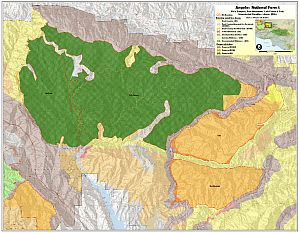
Alternative 2 Map – Click for a larger version

Alternative 1, the “no-action” alternative, is the only alternative we can presently support.

Alternative 2 retains a backcountry non-motorized status for Red Mountain and Tule districts, but it appears that the trails in the Fish Canyon/Salt creek areas may be forever closed. These trails have appeared in guidebooks dating back to the 90’s, and we have ride reports from much more recent times. We asked for these trails to be left out of any wilderness proposals.  There are many other trails, official and unofficial, in the area, and we’re seeking documentation of those trails. If you have knowledge of these potentially affected trails, let us know. We could support Alternative 2 if the trails in question are cherry-stemmed out of the wilderness proposal.

In Alternative 3, the Fish Canyon/Salt Creek proposed wilderness on which we commented last year has now been expanded to include the Red Mountain and Tule districts of the Angeles National Forest. These two areas lie to the east and south of the Fish Canyon/Salt Creek area. These two areas were not included as potential wilderness in the original scoping documents, and we therefore made no comment on them, other than to offer our general support for their designation for non-motorized backcountry use.  Now, in Alternative 3, these two areas and the many trails that traverse them are included as wilderness. Local riders have been riding these trails for more than 30 years, right up to the present. We cannot allow Alternative 3 to be adopted.

We too would like to see these areas protected, and feel that backcountry non-motorized designation gives the area adequate protection, but the environmental lobby is pushing for federal wilderness. We have proposed a compromise, a federally designated Special Conservation Area, which prohibits extractive use, development and road-building and can be custom tailored to allow for non-motorized recreational use, while affording stronger protection for and monitoring of the environment. This would require special legislation.

After the public meetings in March, we will be compiling and submitting our comments on the proposals. We encourage everyone to submit comments on the proposals, along with supporting documentation (GPS tracks, photos) of bicycle use of the trails. The comment period will close on May 16, 2013.

The Forest Service will be hosting multiple open house meetings during the comment period. The content and format of each meeting will be the same. Meetings will begin with an open house where Forest Service staff will be available to answer questions about the Draft SEIS. A brief presentation will begin 30 minutes after the meeting opens, followed by an opportunity to ask questions. Maps of the alternatives will be available for viewing. The meeting times and locations are:

  • March 26, 2013, 4:00 PM to 7:00 PM, Angeles National Forest Headquarters, 701 North Santa Anita Avenue, Arcadia, CA 91006 
  • March 26, 2013, 4:00 PM to 7:00 PM, Alpine Community Center, 1830 Alpine Blvd, Alpine, CA 91901 (Hosted by the Cleveland National Forest)
  • March 27, 2013, 4:00 PM to 7:00 PM, Palomar Ranger District Office, 1634 Black Canyon Road, Ramona, CA 92065
  • March 28, 2013, 4:00 PM to 7:00 PM, Santa Clara Mojave Rivers Ranger District Office, 33708 Crown Valley Road, Acton, CA 93510 
  • March 28, 2013, 5:00 PM to 7:30 PM, San Bernardino National Forest Headquarters, 602 S. Tippecanoe Ave., San Bernardino, CA 92408
  • April 9, 2013, 4:00 PM to 7:00 PM, Mt. Pinos Ranger District office, 34580 Lockwood Valley Road, Frazier Park, CA 93225
  • April 10, 2013, 4:00 PM to 7:00 PM, Southern California Edison, 103 David Love Place, Goleta, CA 93117 (Hosted by Los Padres National Forest)

For Further Information Contact Bob Hawkins, Project Manager atsocal_nf_lmp_amendment@fs.fed.us, or visit the
project website at http://www.fs.fed.us/nepa/fs-usda-pop.php?project=35130.


Update 3/25/2013:  We have learned more about the draft proposals and reported here.


Angeles National Forest Land Management Plan Ammendment Comments

Friday, June 8th, 2012

We recently put out an alert  about court-ordered changes to the Land Management Plans for our four Southern California National Forests. We’ve now attended the public meetings, pored over maps and GIS data and have put together our official comments on the plan, available as a PDF, and copied below.

IMBA has recently put out an action alert and petition to preserve mountain bike access to all existing multi-use trails in our four National Forests. We encourage everyone to sign the petition.

In the Angeles National Forest the only area in which we see the potential for problems is the proposed change of the Salt Creek and Fish Canyon Inventoried Roadless Areas into the combined Fish Canyon Recommended Wilderness (RW).  The Golden Eagle trail is an extremely popular, well-documented trail used frequently by bicycles. It is not on any forest service maps and is not an offiicial forest service trail, though it has existed for at least 25 years. We would of course like to see this brought into the trail inventory, and excluded from any recommended wilderness. The trail lies outside the RW, except for one section where it is impossible to tell from the data supplied whether it touches the RW boundary, or crosses it.  We would like to see the boundary adjusted to provide a reasonable buffer between this trail and the RW.

Similar incursions into or across the RW boundaries appear to occur on the fire roads to Knapp Ranch and Atmore Meadows. They are probably just anomalies of the scale of maps used and data supplied, but must be clarified to be sure these fire roads are outside any RW.

The RW includes several miles of singletrack trails that have a history of bicycle access. These include the Burnt Peak Canyon trail and Fish Canyon trail. However, both of these trails are in a dilapidated state and have seen very little use by bicycles, or other users for that matter. In his 1990 guidebook to the area, Mike Troy describes the Fish Canyon trail (16W05) as a difficult hike a bike and the trail as unmarked and difficult to follow. The Burnt Peak Canyon trail, on the other hand, is described as a fun, non-technical double-track.  We will endeavor to gather more data about the existing conditions of these trails, but for the moment we are asking that they be left as Backcountry Non-Motorized (BCNM) rather than RW.

While we support the ongoing preservation of our remaining open space and prevention of future disruptive development or extractive use of the land, trails are a limited resource and losing trails reduces our future options for recreational access. A RW designation will make these trails more difficult to restore or maintain, and we risk losing them forever.

We encourage everyone to send comments via email to socal_nf_lmp_amendment@fs.fed.us or snail mail to: Attn: LMP Amendment, Cleveland National Forest, 10845 Rancho Bernardo Road, Suite 200, San Diego, CA 92127-2107.

CORBA’s submitted comments follow the break.


(more…)

Recommended Wilderness Proposals in our National Forests

Thursday, May 31st, 2012

In response to a lawsuit, the four Southern California Forests are proposing amendments to their 2006 plans. They are proposing new Backcountry Non Motorized Recreation zones as well as new Recommended Wilderness designations. Several mountain bikers attended the informational workshop at the Angeles National Forest Headquarters on May 30, along with concerned forest users, and many from groups like the Sierra Club, The Wilderness Society and others.

In the Angeles National Forest there is a recommended Salt Canyon, Fish Creek roadless areas were combined to create a 40,000 acre Recommended Fish Creek Wilderness in an area that was Backcountry Non-Motorized. It is now Forest Service policy that a Recommended Wilderness designation will be managed as if it were wilderness and the area will be closed to bikes.

Concerns have been raised about the status of several significant nearby trails that bicyclists ride. We’re happy to report that the Golden Eagle Trail and the Warm Springs/Elderberry Forebay/Fish Canyon fire road Loop are unaffected by this proposal. Wilderness boundaries have been drawn with “cherry stems,” areas of non-wilderness along the existing fire road corridors. the same has been done for the Burnt Peak fire road.

We do have concerns about the Fish Canyon Trail (1GW05) and the Burnt Peak Trail (1GW02). These run generally north-south right in the middle of what would be the new Wilderness. We heard from several people that these trails may be overgrown and quite deteriorated. We need to know if riders have ridden them and are currently riding them. Despite their current condition, if they go into Wilderness, bikes will be excluded and the trails will likely never be restored due to Wilderness Trail maintenance issues. We might lose a significant future opportunity for a ride in a wild landscape. If you have information about these trails, let Steve Messer (steve@corbamtb.com) and Jim Hasenauer (imbajim@aol.com) know.

There are also many changes including Recommended Wilderness Proposals in the Cleveland National Forest, the Los Padres National Forest, and the San Bernadino National Forest. Unfortunately for those who visit all four forests, only the Angeles National Forest proposed management plan revisions were available for review at last night’s event.  If you are concerned about changes in other forests, it will be necessary to meetings. Mountain bike advocates are monitoring the meetings and will soon have talking points for your comments. The deadline for comments is June 11, 2012.

Information about the Forest Manamagement Plan revision process is at http://www.fs.fed.us/nepa/nepa_project_exp.php?project=35130

CORBA”s first comment is that the online data supplied is not of sufficient detail or quality to make informed decisions about any new proposed changes in the management plans for the forests. Without real data that we can zoom in on (digitally) and use with the mapping and GIS tools with which we’re familiar, it is impossible to see what areas and trails may be affected in the detail needed to make informed comments. We’d like to see KML or Shapefiles that can be used with the most popular mapping tools for this, and any future NEPA or CEQA documents.

Though we don’t know the current state or conditions of the Fish Canyon and Burnt Peak singletracks, we would like to see the boundaries adjusted to allow continued bicycle access to these trails. We’ll formulate our final comments after we gather more information on these and other affected trails.  Deadline for comments in June 11.

The current designation: Backcountry non-motorized:

The proposed Recommended Wilderness (in dark green):


Remaining meetings are scheduled as follows:


• May 31,2012, 4:00PM to 7:00PM, Santa Maria Red Cross, 3030 Skyway Drive, Santa Maria, CA 93455 (Hosted by Los Padres National Forest)
• May 31, 2012, 4:00PM to 7:00PM, Santa Clara Mojave Rivers Ranger District Office, 33708 Crown Valley Road, Acton, CA 93510
• May 31,2012,4:00 PM to 7:00PM, San Bernardino National Forest Headquarters, 602 S. Tippecanoe Ave., San Bernardino, CA 92408.
• May 31, 2012,4:00 PM to 7:00PM, Palomar RangerDistrictOffice, 1634 Black Canyon Road, Ramona, CA 92065 ·
• June 1, 2012, 1:00PM to 4 PM, Frazier Park Library, 3732 Park Drive, Frazier Park, CA 93225 (Hosted by Los Padres National Forest)
• June 5, 2012, 4:00PM to 7:00PM, Descanso Ranger District office, 3348 AlpineB!vd, Alpine, CA 91901
• June 5, 2012,4:00 PM to 7:00PM, Trabuco Ranger District office, 1147 E. 6th Street, Corona, CA 92879