Archive for the ‘Trail Hazards’ Category

MRT Begins Mustard Eradication on the New Millennium Trail

Tuesday, March 29th, 2011
New Millenium Trail in 2008, without eradication efforts

New Millenium Trail in April 2008, without eradication efforts

Today, March 28, the Mountains Restoration Trust will begin eradication of the invasive Mustard plants along the New Millennium Trail. Each year by early summer the mustard can choke off the trail and render it near-impassable. This is especially true after above-average rainfall seasons like we’ve experienced this year.

This picture from April 2008 shows how the New Millennium Trail will likely look again if no eradication effort is undertaken.

CORBA has provided funds to the MRT to help support their efforts. This will save many days of brush-clearing trailwork in the early summer, allowing us to concentrate on other trailwork efforts.

We thank the MRT for helping keep this much-loved trail rideable for all.

Mountains Restoration Trust is now taking reservations for the 2011 Rattlesnake Avoidance Clinic for Dogs

Friday, January 28th, 2011

MRT is pleased to announce the 2011 Rattlesnake Avoidance Training Clinic For Dogs with Tracy Jenson-Presson of High on Kennels, San Diego County. Tracy has many years of experience training dogs to avoid rattlesnakes. She is well known for being a problem solver when it comes to difficult dogs. We have checked her out and you’re welcome to visit her website at: www.highonkennels.us

The training is conducted in a safe, humane, controlled environment ensuring the safety of your dog, as well as the safety of the rattlesnakes. The training process is repeated several times to insure that the dog understands the sight, smell and sound of a rattlesnake (Rattlesnakes have a distinctive odor that dogs can discern from other snakes) We have found that some dogs seem to forget over a period of time and recommend annual training for all dogs.

March 19 & 20 and April 16 & 17
Where: Headwaters Corner, Masson House, 23075 Mulholland Hwy, Calabasas, CA 91302
When: 8 am to 5 pm
And
May 14 & 15 and June 11 & 12
Where: Tapia Park, 884 North Las Virgenes Rd, Calabasas, CA 91302
When: 8 am to 5 pm

Go to the MRT rattlesnake clinic page to register your dog for training.

FHA Plans for Mueller Tunnel, Mt. Lowe Fire Road

Monday, January 24th, 2011

Mueller Tunnel 2006, Mount Lowe fire roadThe Mueller Tunnel has long been a right-of-passage for many mountain bikers riding the outstanding front country trails of the Angeles National Forest.  It is near Eaton Saddle along the Mount Lowe Truck Trail. The tunnel was closed after a landslide almost sealed the western end of the tunnel in 2009. The area has experienced many rock slides over the years. The steep, rocky terrain above the tunnel and fire road remain unstable and unsafe.

There has also been significant damage to the retaining walls which support the fire road next to the tunnel. Several years of heavy rain, and the subsequent Station Fire have kept the area closed for some time. In its current condition, the Mount Lowe Fire Road would remain closed even if the Station Fire closure order was removed.

Mt. Lowe Fire Road provides mountain bikers and hikers access to the Mt. Lowe trail, Sam Merrill Trail, Idlehour trail, and was a popular shuttle option from Mt. Wilson road. It was originally constructed in 1942. It also provides volunteer trail crews like CORBA’s convenient access to those trails for trailwork.

The Federal Highway Administration and the Angeles National Forest are proposing to reconstruct a portion of the roadway adjacent to the tunnel, to restore through access for Forest Service and fire fighting vehicles as well as for hiking, mountain biking and equestrian use. The construction would involve a new retaining wall to tie in to what remains of the existing retaining wall. The objective is to restore the fire road to existing roadway widths and stabilize the road.

Mueller Tunner riders, 2006, Mt. Lowe fire roadThe Federal Highway Administration is requesting public feedback on the project.  Feedback should be sent in by March 4, 2011 to Mr. Micah Leadford (HFPM-16), Federal Highway Administration, 12300 West Dakota Avenue, Suite 380, Lakewood, CO 80228 or by email to micah.leadford@dot.gov; by telephone at 720-963-3498.

CORBA will be submitting our feedback in the comings weeks.

Riding after It Rains

Thursday, December 30th, 2010

Most trails in our local riding area don’t respond well to rain. They have a high content of clay that turns into sticky, slippery muck that binds to everything it touches. It builds up on the tires, like a snowball rolling downhill, until it jams on the frame and the wheels won’t budge. Some models of clipless pedals refuse to yield when full of this mud, resulting in the bike and the attached rider lying sideways in a puddle.

Most wet trails don’t respond well to bikers, hikers or equestrians until they’ve had time to dry out. Hikers and horses make holes and ridges in the trail that become as hard as concrete when the trail dries. These holes and ridges are good for twisting ankles of trail users who aren’t constantly watching their step.

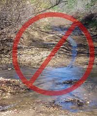
On wet trails, bikes make grooves down the middle. These grooves collect water when it rains again, turning first into little channels to move the water downhill, then into little ruts, then large ruts that destroy the trail. You’ve heard about the beat of a butterfly wing that causes a hurricane? Then remember the tire track that turns a tail into one large rut!

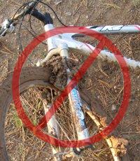
And the mud is particularly hard to remove. It sticks to the bike and shoes, no matter the efforts to remove it, rubbing off on the bike rack, car carpet and floor pedals. Once home, it takes the careful use of a garden hose to remove the mud but not force water into the sensitive parts of the bike.

For these reasons, riders are well advised to stay off the trails after a rain until they have dried. How long to stay off? That depends on a number of factors including the particular trail, how much rain it received, how much sun it gets after the rain (is it in the shade or face south?), how warm and windy the weather is, and so on. After an isolated light rain you can probably ride the next day. After a heavy rain, you should wait several days. This is something where common sense and experience will help.

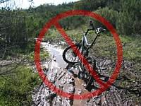
But if the trails are soaking, all is not lost if you need to ride! There are a few trails that hold up well when wet because they have more sand and rock that doesn’t hold the water. Here are a few you should know about:

Space Mountain (Los Robles West) to the picnic table is almost always rideable, even right after a big storm. However, it can be pretty mucky from the picnic table to Potrero Road.
Rosewood Trail is pretty good, but not quite as resiliant as Space Mountain.
Zuma Ridge Motorway from Encinal (the bottom in Malibu is muddy)
Dirt Mulholland around Topanga State Park.
-Brown Mountain Fireroad
-Most San Gabriel Mountains trails made up of decomposed granite
-Beaudry Fireroad
-Hostetter Fireroad
-Mt. Lukens

Trail Maintenance: Get the Water Off to Preserve the Trail

Monday, November 15th, 2010

This rut on the Wood Canyon Vista Trail doesn't look like much now, but left to itself, it will evenutally consume the entire trail!

Running water is responsible for well over 90% of trail damage. Last winter we had a lot of rain that heavily damaged the Wood Canyon Vista Trail (and others), leaving it with deep ruts and loose rocks. The State Park maintenance staff fixed the ruts by running a SWECO (mini bulldozer) up the trail, and then new drainage channels were cut by CORBA and other volunteers.   

The number one trail maintenance objective is to get the water off the trail to keep new ruts from forming. During normal trail use, a ridge of dirt and rocks forms on the outside edge of the trail. This is called a berm and it keeps the water from running off the trail. We allow the water to drain off by constructing what are called ‘rolling dips’ or ‘grade dips.’ This is done by digging a depression in the trail, a few inches deep and sloped to the downhill side. We also cut out the berm so that water will be diverted off when it runs into the rolling dip. Downhill of this depression, we build a low mound called a ramp, slanted about 30 to 45 degrees across the trail, to act as a dam, a barrier of last resort to keep water from running down the trail.   

Riding over a newly constructed rolling dip.

The shallow depression should be about three to five feet long and a few inches deep, and the downhill ramp should be two to four feet long and a few inches high. The transition from the depression to the downhill ramp shouldn’t be so steep that tires won’t roll over them easily either uphill or downhill. Our first concern is safety and we don’t want anyone to have difficulty riding over them.   

We purposely make the depression a little deeper than needed, and the ramp a little higher. This is so the rolling dips don’t wear out too soon. We don’t want to have to rebuild them every few months! The ramp becomes more packed down over time, and, especially when it’s new, mountain bike tires can cut into it and disperse the dirt. The shallow depression will slowly fill up with silt and eventually won’t channel the water off the trail. In fact, the rolling dips that were built last spring on this trail were already choked with silt from some recent rainy days.

Mountain Bikers Preserving the Trails

Monday, November 8th, 2010

Sunday’s trailwork on El Prieto went exceptionally well. We had perfectly cool, clear weather, damp soil that was easy to work with, and good spirits all around. Thanks to the approximately 50 people who came out to show this heavily damaged trail some much-needed love.

Rock Armoring Teamwork

Rock Armoring Teamwork

In over 320 person-hours of labor, several washed out drainages were restored, brush was cut back, and many vulnerable sections of the trail tread received rock-armoring treatment. We were even able to restore one section of the original trail that had all-but vanished since the fires. With some diligent hand-tool work and brush cutting, the “cactus corner” section was re-cut and benched, and is ready for finish work.

Special thanks to the St. Francis high school mountain bike team, who came out in force to contribute. Of today’s volunteer trailworkers, more than half were high school team mountain bikers.

As high school students, not only did they learn about trail construction and sustainability, they also gained insight into what makes a “good” trail: how it flows, how it handles water, how sight-lines affect safety on the trail and many other tidbits that one usually doesn’t have time to think about when riding a trail.

Another wonderful aspect of high-school team riders is that many of their parents also get involved. Many are introduced not only to the sport of mountain biking, but to volunteerism and trail stewardship. At least eight parents of high school racers also put sweat equity into the trail on Sunday.

The Forest Service is also requiring all volunteer trail working groups to use safety gear including gloves and hard hats. Thanks to the generous support of REI we were able to outfit all our volunteers with hard hats, a first for CORBA trail crews. We also thank Flat Attack tire sealant for their support of CORBA’s programs.

Special thanks also to Banner Moffat and the Friends of El Prieto, for their ongoing regular work that has helped keep this trail from disappearing altogether since the Station Fire, even though it remains closed to the public. We’re hoping that El Prieto will be a top priority for re-opening by the FS after the rain season ends.

El Prieto trailwork

The original trail restored

Flash flooding and unstable hillsides are still major concerns, and the reason this and many other Station Fire trails will remain closed at least through next spring. In a recent meeting with the non-motorized trails supervisor for the forest, we discussed some creative ways that CORBA, the Friends of El Prieto and other volunteers might work together to open this trail sooner, rather than later. Some possibilities might include a “conditional” opening, where the trail would be closed at any sign of rain, and surveyed after each rain for safety. At this point, the mountain bike community would welcome any access to El Prieto.

Keeping the trail in good shape is the first and most important step towards that goal. Thanks again to everyone who came out!

Sullivan Canyon Update November 2010

Wednesday, November 3rd, 2010

From Sharon O’Rourke, The Gas Company

I wanted to give you an update of our Sullivan Canyon Pipeline Protection Project.  The project will take longer than originally estimated due to the recent rains we have experienced.  We originally expected to complete the work sometime by November 12th.  The new estimate for completion is now December 10th, weather permitting.

On August 4th, we started construction to repair the access road and install protective concrete mats over 12 pipeline exposure areas.  These exposure areas make the pipelines vulnerable to damage.  Of the 12 exposure areas, 8 pipeline areas have been inspected, repaired and covered with the protective concrete mats.  We have 4  exposure areas to complete.

Due to on-going pipeline construction activity, public access to Sullivan Canyon remains closed.

Pinecrest Gate to the Mt. Wilson Toll Road

Friday, October 29th, 2010

For those of us who ride the Mount Wilson toll road, we’ve all faced the prospect of racing to beat the closure of the gate at Pinecrest Avenue at dusk.

Unofficial-looking, hand-made signs on the Pinecrest GateMountain bikers are not the only ones affected by this troublesome and potentially hazardous gate. Hikers, equestrians and dog walkers also face the prospect of being trapped behind the gate after dark.

For cyclists, this is especially troublesome as there is no alternative legal place for cyclists to exit without backtracking up the Mt. Wilson Toll road or Altadena Crest Trail to an alternate trailhead. Bicycles are prohibited in Eaton Canyon, which is in itself a hazardous journey after dark for all trail users.

The Altadena Crest Trail Restoration Working Group has recently made their feelings on this foreboding gate known to the Mayor of Pasadena and other key government officials. CORBA fully supports their position, demanding that the gate be removed or replaced. Our official letter to the Mayor of Pasadena and other officials is below and continues after the break.

We encourage all concerned trail users to write to the Pasadena’s Mayor and City Council to express your feelings about the Pinecrest Gate situation.

The Pinecrest Gate, as seen on Google Street View. The now-repaired landslide is visible if you rotate the image to the right:


View Larger Map

A PDF copy of the letter is available for download, or read on below:

October 26, 2010

Hon. Bill Bogaard, Mayor
City of Pasadena
100 N. Garfield Avenue, Room S228
P.O. Box 7115
Pasadena, CA 91109-7215

Re: Pinecrest Gate at Eaton Canyon Park

Dear Mr. Mayor,

We urge you to remove or open the Pinecrest Gate to allow full 24/7 recreational access to the Altadena Crest Trail, the Mount Wilson Toll Road and Angeles National Forest.

As a non-profit serving and representing off-road cyclists from the greater Los Angeles region, CORBA has received numerous reports from our concerned members about the condition of the Pinecrest gate. The Pinecrest trailhead is a historically significant and popular access point to the Angeles National Forest for off-road cyclists, hikers and equestrians alike.

(more…)

CORBA Adopted Trail Damaged by Water Spill

Tuesday, August 31st, 2010

by Danusia Bennett-Taber 

COSCA Los Robles West Potrero trailhead. The spill-induced rut is much worse a little further up the trail.


A power outage at a local water facility caused substantial damage to our COSCA (Conejo Open Space Conservation Agency) adopted trail – Los Robles West / Potrero trailhead section. On Saturday August 21st hundreds of gallons of water poured down this trail  opening huge ruts and even damaging the parking lot. 

COSCA is trying to find the responsible party so they can repair this damage. Until that happens, be aware of this damage and ride safely. 

Beware of Bees Near the New Millennium Trails in Calabasas

Monday, August 30th, 2010

It's better to avoid bees than to try to outrun them.

There are been reports of bees or yellow jackets attacking mountain bikers riding near the New Millennium Loop trails in Calabasas. This past weekend, riders on the Historic Trail (trail #8 at the top of this map) reported that angry bees followed them for several hundred yards. Most riders were stung multiple times. A similar incident occured a few weeks ago during a night ride in the same area. One member of that ride said the bees had a nest in the ground, on the inside corner of a switchback. All riders were stung about a dozen times. 

We don’t have any advice on what to do when confronted by angry insects other than “Ride away as fast as hell! Don’t stop until well beyond where the bees stop chasing you.” Instead of trying to outrun these bees, it would be smarter to avoid this trail as long as there are bees there.

CORBA has alerted the land managers for the area about this problem.