Archive for the ‘Trail Access’ Category

How is COVID-19 Affecting Your Riding?

Thursday, July 23rd, 2020


We all wish things were back to the way they were before the novel coronavirus changed all our lives so drastically.  With LA County’s Covid numbers are still at disturbingly high levels, nobody is predicting a return to normal any time soon.

As we adjust to this new normal, we’d like to find out how COVID-19 has changed or otherwise impacted your riding, and what you’re seeing on trails.

We’ve compiled a quick survey that should take just a few minutes to complete. The survey asks for the top three most significant changes to your riding habits, face coverings, and where you ride.

No personally identifiable information is being requested or collected and your answers will only be reported in aggregate. The survey will help us figure out where we’re at, and what mountain biking is going to look like over the next year.

The survey is at https://forms.gle/7xDAz68aXnNYD7FX9

We really appreciate your input.

LWCF Funding Bill Hits the Senate Floor

Monday, June 8th, 2020

The Senate is expected to vote on the Great American Outdoors Act this week, and needs to hear from you! The Act would mean billions of dollars for trails, parks, and public lands across the country. This is a monumental victory for mountain biking and outdoor recreation!

The Act fully funds the Land and Water Conservation Fund (LWCF), and addresses the trail maintenance backlog for the National Park Service, the Forest Service and the Bureau of Land Management. IMBA and our partners worked hard to include the Forest Service and Bureau of Land Management in the Act, as those agencies are vital for mountain biking.

Mountain bikers  helped get this Act introduced in the Senate in March, after your voices permanently reauthorized LWCF earlier this year. And now, the finish line is in sight. (Then the real work for trails can begin!)

But these bills aren’t a sure thing. Can you help by writing a message to your members of Congress? IMBA’s easy tool customizes your message based on your elected official’s level of support, and you can make it even more powerful by personalizing it.

This is an incredible opportunity for trails. Show your support today!

Take Action!

Sullivan Canyon Gas Company Construction through June

Sunday, May 10th, 2020

This week the SoCal Gas Company, who own the land through Sullivan Canyon, will be doing pressure testing and maintenance on their pipelines. The work will take place Monday through Saturday, from 7 am to 5 pm, near the Queensferry Road area. The work is expected to finish sometime in June.

Though trails in the area have begun to open after the shelter at home orders were eased. When construction equipment is present, Sullivan Canyon will be closed. The work sites will be off-limits for recreation. Please avoid the area and obey any signage, or the  guards who will be on site. Sullivan Ridge is not affected.

The official notice is here: Hydrotest_2020_Sullivan Canyon

Forest Service Closes Trails, Rec Facilities

Friday, April 3rd, 2020

Today, April 3, 2020, the Forest Service  issued a closure order for many popular trails that have seen higher than normal use, and lower than needed social distancing. People longing to escape their homes and recreate have flocked to open spaces since the beginning of the closures related to Covid19. After three weekends of trying to encourage social distancing, the only way to enforce people to maintain social distance is to close trails.

The closure is in effect from April 4, 2020 through April 30, 2020. The full closure order, including maps, is available at https://www.fs.usda.gov/Internet/FSE_DOCUMENTS/fseprd720172.pdf

The Forest Service order closes the following Trailheads:

  • Millard Canyon
  • San Antonio Falls (Baldy Bowl)
  • Icehouse Canyon
  • North Devil’s Backbone.

And the following popular fire roads and trails are closed:

  • Gabrielino Trail
  • Kenyon Devore trail
  • Mt. Wilson Trail
  • RIm Trail
  • Valley Forge  Trail
  • Sam Merrill Trail
  • Sunset Ridge Trail
  • San Gabriel Peak Trail
  • El Prieto Trail
  • Ontario Peak Trail
  • Bear Canyon Loop Trail
  • Devil’s Backbone Trail
  • Telegraph Peak Trail
  • Mount Baldy Trail (Bear Canyon)
  • Bighorn Peak Trail
  • Chapman Trail
  • Timber Mountain Trail
  • Icehouse Canyon Trail
  • Three T’s Trail
  • Baldo Bowl trail (San Antonio Falls)
  • North Devil’s Backbone Trail
  • Joatnga Interpretive Loop Trail
  • Acorn Trail
  • Big Santa Anita Road
  • Mt. Wilson Toll Road
  • Mt. Lowe Road
  • Disappointement RIdge Road
  • Chaney Trail/Millard Canyon Road
  • Brown Mountain Road
  • Millard RIdge Road
  • Arroyo Seco Road
  • Mt. Lukens Road
  • Earl Canyon Motorway
  • Oliver Road
  • Doane Ebey Road
  • Doane Canyon Road
  • May Canyon Road
  • WIlson Canyon Road
  • Potato Mountain Spur
  • Palmer Evey Canyon Road

At this point we should assume all trails and open spaces in and around Los Angeles and Ventura Counties are off limits, even if they are not specifically closed.

This closure is temporary, expiring April 30, and we’ll update as needed.

Pedaling through a Pandemic

Monday, March 23rd, 2020
Cheney trail, one mile from the trailhead

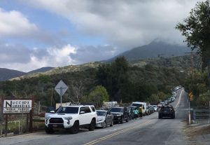
Illegal overflow parking 1.1 miles from the Sunset Ridge trailhead yesterday.

These are unprecedented times. We’ve all been constantly bombarded with reminders to avoid social contacts, maintain social distancing, and shelter at home. Those orders came with the caveat that it’s OK to get outside and get exercise, as long as that can be done while maintaining appropriate social distances.

This past weekend was the first under the “Safer at Home” orders currently in effect for Los Angeles city and County.  I feel very much at home on a trail, as do most of you. The instructions to shelter at home and only leave for exercise or to provide or access essential services, sounded to me like an invitation and a perfect reason to hit a local trail. It sounded like an invitation to the entire community.

This led to some serious crowding on our local trails this past weekend.  It is impossible to maintain appropriate social distancing, which includes physically separating individuals by at least six feet, on a two-way trail less than four feet in width. Trails are social, and many groups were seen heading out together onto trails. Many trailhead and park parking lots were closed, but this didn’t stop people from parking outside established parking lots, often illegally, and accessing the trails anyway.

Since it seems the public are unable or unwilling to recreate in a way that maintains social distancing, we recommend avoiding all singletrack trails. In fact, as of Saturday, March 28, all trails in Los Angeles County are closed, with the exception of trails on federal land in the Angeles National Forest which remain open. The following official closures are now in effect (subject to change):

  • All organized club rides, races and events have been canceled.
  • Santa Monica Mountains Conservancy/MRCA have closed all their parks and trails to the public.
  • LA County has closed all County trails and parks to the public, including the Pinecrest gate access to the Mt. Wilson Toll Road.
  • La Canada Flintridge have closed all their trails, including Cherry Canyon.
  • City of Monrovia has closed the Hillside Wilderness Preserve and all trails.
  • State Parks have closed all park and trailhead parking lots and facilities such as bathrooms and visitor centers at Malibu Creek State Park, Topanga State Park, Will Rogers State Park, and Baldwin Hills Scenic Overlook
  • The National Park Service has closed all park and trailhead parking lots and facilities such as bathrooms and visitor centers in the Santa Monica Mountains National Recreation Area. Soltice Canyon in Malibu is closed to all entry. NPS Trails will be closed from 2pm Fridays to 6am Mondays until further notice.
  • The Forest Service has closed all campgrounds, visitor centers and developed recreation sites, throughout Region 5 (California).  Additionally, the Angeles National Forest has closed most of the front country trails and trailheads.
  • LA County DPW have closed Big Dalton Canyon Road, Glendora Mountain Road (north of Big Dalton Rd to East Fork Rd) and Glendora Ridge Road (Glendora Mountain Rd to Mt. Baldy Rd). These roads will remain closed until the emergency order is lifted.
  • City of Glendale has closed all park, trails and fire roads including the Catalina Verdugo trail and trails in Deukmejian Wilderness Park and the Verdugo Mountains.
  • The City of Los Angeles has closed all parks, trails, skate parks, and public amenities, including Griffith Park and all beaches.
  • The City of Palos Verdes has closed all parks, trails, and open spaces.
  • Conejo Open Space Conservation Authority has closed all parks, trails and open spaces in their jurisdiction.
  • The City of Pasadena has closed the Rose Bowl Loop
  • The Forest Service has closed many trails, campgrounds, trailheads and recreation facilities as listed on their forest order.
  • SoCalGas Company has closed Sullivan Canyon, which is private property owned by the gas company.

It isn’t just mountain biking trails that are affected. The City of Santa Monica and County of Los Angeles have closed all beach parking lots. Portions of the Marvin Braude Bike Path around Venice and Santa Monica have been closed. The Ballona Creek bikeway, and LA River Bikeway and other County bike paths have been closed. The Pacific Crest Trail Association has alerted all through-hikers to cancel their 2020 plans.

While we understand everyone’s need to get out and exercise, enjoy our cleaner air and reduced road traffic, your health and the health of everyone in our community takes priority.  If trails continue to be crowded, we can expect more trail and park closures, over and above the closures already in effect.  We strongly advise adhering to official guidance from State and County public health departments, and/or the land managers themselves, though it can be difficult to decipher:

Centers for Disease Control and Prevention (CDC) https://tinyurl.com/tllxvcc

California Department of Public Health (CDPH) https://tinyurl.com/uw57yjx

Ventura County Health Care Agency http://www.vchca.org/agency-divisions/public-health

Los Angeles County Public Health http://www.publichealth.lacounty.gov/media/Coronavirus

While it’s now recommended just to stay at home or ride the streets near your home, if you choose to ride any of the few trails still open, here are some general guidelines:

  • Stay home if you’re sick. Period. It goes without saying, but we’re going to say it anyway – if you’re sick, or you’ve been in contact with somebody who is, you need to stay home.
  • Only ride open trails from open trailheads.  Agencies are monitoring the crowds on trails, and some trails (including all Santa Monica Mountains Conservancy trails) are now closed to all users. If we can’t maintain social distancing on trails, expect more closures. Check with the agencies if you’re not sure.
  • Maintain your distance. AT ALL TIMES maintain the safe, responsible social distance we’ve all come to know – keep 2-3 bike lengths between riders, on the trail and off the trail.  Don’t fist bump, etc., rather stick to air-fives and sharing content online. Allow ample passing room for other trail users. Ride only with your housemates/family, or those with whom you already have close physical contact. 
  • Find a lesser-used used trailhead. People are heading out in record numbers.  If you’re fortunate enough to know of more remote, lesser-used trailheads, please plan your ride so that you start there. Refrain from driving to trailheads wherever possible.
  • Ride to your ride.  If you are able to ride to a trailhead, do so.  Keep the cars off the road, out of the gas stations, and away from congested areas.  Balance this with avoiding crowded trailheads.
  • Slow it down.  Now is not the time to push your riding skills.  The last thing you or the rest of the community wants right now is for a rider to wreck and end up in a hospital, adding more strain on our EMS system and taking up valuable resources.  Plus, you’ll also be able to enjoy the benefits of being outdoors for a longer period of time if you slow your roll.
  • Take care of business before heading out.  Many public restrooms are closed – make every effort to make sure nature doesn’t call while out on the trail.
  • No snot rockets.  We get it, and usually we accept it – but if you need to blow your nose, use a hanky.  If you do need to sneeze, do it into your elbow.
  • No sharing.  Now is not the time to share gear, food, drinks, or tools.  Sorry. If you have a mechanical issue, sanitize tools and gear before sharing and again before taking it back.
  • Protect yourself.  Bring a small “to go” packet of hand wipes, disinfectant spray, and maybe even some soap to use with your own water.  Hopefully you won’t need this, but just in case you do it’s better to have it than not.

With all this in mind, think before you ride, keep it local, and don’t put yourself or others at risk. All of this will pass, and we’ll be planning group rides and trailwork events again soon.


Edit: Updated 3/23/2020 at 3:00 pm to reflect additional road closures.
Updated 3/23/2020 at 8:00 pm to reflect Cherry Canyon closures.
Updated 3/25/2020 to reflect City of Glendale closures
Updated 3/27/2020 to reflect City of Los Angeles and Palos Verdes closures
Updated 3/28/2020 to reflect COSCA closures
Updated 4/3/2020 to reflect Forest Service and Big Dalton closures
Updated 4/14/2020 to reflect Sullivan Canyon closures


Dead Cow Trail Closed by NPS

Saturday, March 7th, 2020
Dead Cow Trail, 2017

Dead Cow Trail (pre-Woolsey Fire)

The National Park Service has closed Dead Cow trail in the Cheseboro area of the Santa Monica Mountains National Recreation Area. The trail runs between Paolo Comado and Sheep’s Corral. They also closed an illegally constructed trail in the vicinity, which had its own safety concerns and negative impacts to the area.

Dead Cow has been gradually degrading over the years, making it one of the more technical trails on National Park Service land. It is also in dire need of maintenance and safety improvements. When an uptick in injuries and accidents was seen over the last year, NPS rangers attention was drawn to the area. They inspected Dead Cow trail and discovered the unauthorized trail in the vicinity.

This closure is the direct result of a few rogue mountain bikers, who, without concern for the impact of their actions or its repercussions for the mountain biking community, illegally constructed a trail in the vicinity of Dead Cow. This took place as nearby neighborhoods were still in recovery from the Woolsey fire, and the area’s chaparral was especially vulnerable post-fire.

We condemn this action, and cannot condone any rogue or illegal trail construction on public land. It affects our ability to ask for new trails, and hurts both our image and our relationship with land managers.

CORBA has reached out to the National Park Service, with offers to help inform the public of the closure, and to help do needed maintenance on Dead Cow trail. The areas impacted by the illegal trail will also need rehabilitation and restoration.

The closure stands until further notice, and people who ignore the closure are subject to citation. For mountain bikers who desire jumps, berms and other park-like features, join our Dirt Church maintenance at Sapwi Bike Park every Sunday morning, and help us get to stage 3, with expert jump lines and other features.

Please stay off Dead Cow trail, and spread the word.  Watch for upcoming volunteer work days in the area.

Speak up for funding Public Lands

Friday, March 6th, 2020
We need your help by asking your Senators to fund public lands today.

Apparently the Senate is trying to figure out how to pass two important bills to fund public lands. The outdoor community has been working on them for years, and we have an unusual opportunity to get them passed right now.
These bills – dedicated funding for the Land and Water Conservation Fund (LWCF) and the Restore our Parks Act (ROPA) – will provide funding for parks and public lands and address the deferred maintenance backlog for National Parks. As written, there’s nothing in it for the Forest Service who seem even more chronically underfunded than the other agencies, and we’ve reflected that in our comments.
We need your help to get these bills passed and to make sure that National Forests and BLM lands are also included to receive funding along with National Parks.
The Outdoor Alliance have made it easy to send a message to your Senators right here. The outdoor community has been a powerful force in making public lands funding a priority to Congress, and we need your help to get across the finish line this week.

San Gabriels Protection bill Passes House

Saturday, February 22nd, 2020

Last week four bills affecting California passed the House. H.R.3820, the “San Gabriel Mountains Foothills and Rivers Protection Act”, and H.R.1708, the “Rim of the Valley Corridor Preservation Act,” were rolled into a land protection bill with four other bills including H.R. 2250. the Northwest California Wilderness, Recreation, and Working Forests Act, and the H.R.2199 Central Coast Heritage Protection Act–both of which have earned the support of local mountain biking organizations. Local mountain bike clubs and IMBA have been key players in the development of these bills. The combined bill, H.R. 2546, Protecting America’s Wilderness Act, passed the House on February 12, with 6 house republicans voting in favor.

San Gabriel Mountains, Foothills and Rivers Protection Act
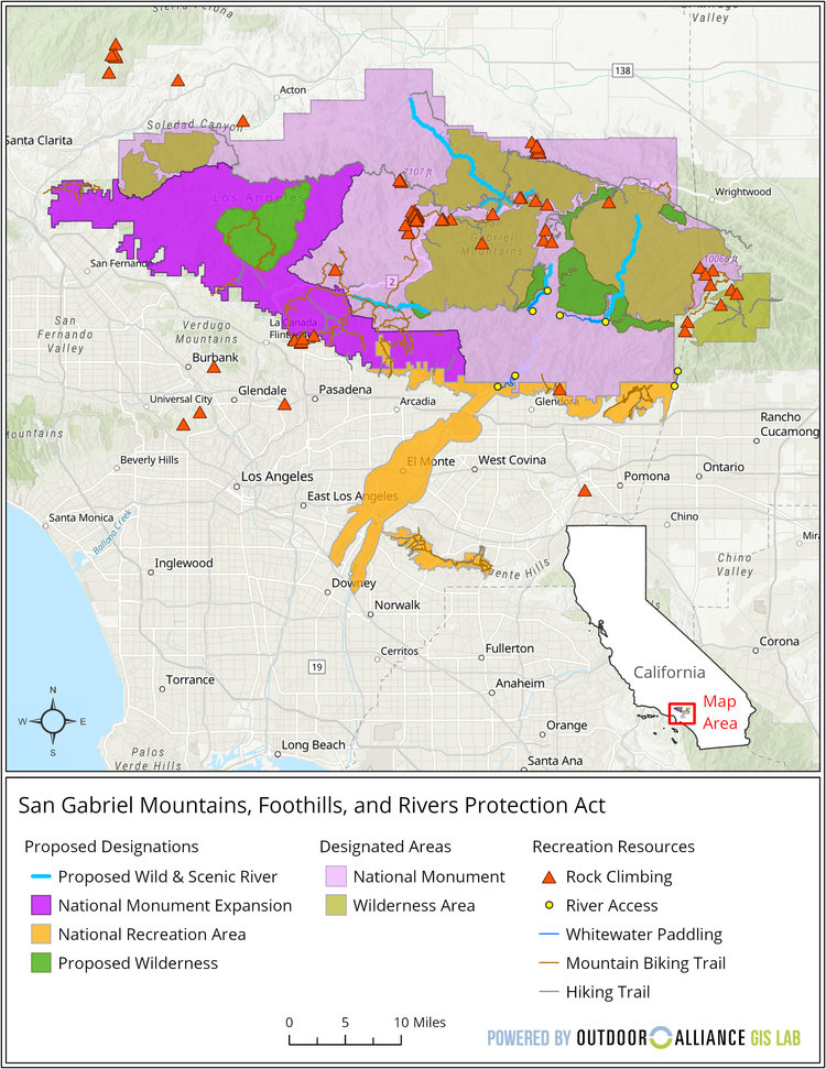
San Gabriel Mountains Foothills and Rivers Protection Act

San Gabriel Mountains Foothills and Rivers Protection Act Reference Map

Wilderness Expansion
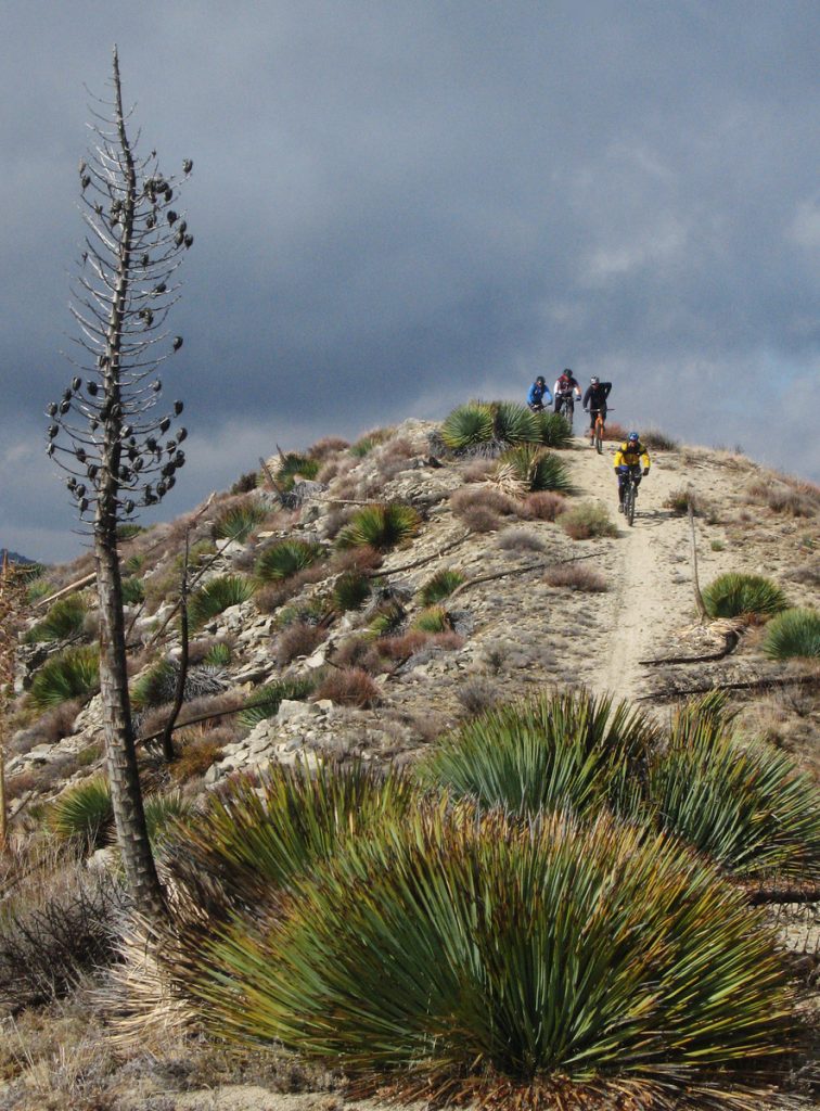
Mountain Bikers descend from Condor Peak

Protest Riders descend from Condor Peak, December 2007

H.R.3820, introduced by Judy Chu (CA-27), expands the boundaries of existing federally-designated wilderness areas within the Angeles National Forest. The bill also creates two new Wilderness areas, the Yerba Buena Wilderness and Condor Peak Wilderness.

Condor peak has long been a target for wilderness protection by environmental groups. It is also one of the last long-distance, high-elevation singletrack trails providing access to a mountain summit that remains open to bikes. It was included in a bill by Barbara Boxer, as a new wilderness area. Jim Hasenauer, then working with IMBA, led a protest ride on the trail showing that it was a high-value trail to mountain bikers on December 1, 2007. It was withdrawn from the Omnibus Public Land Management Act of 2009, but has never been forgotten by environmentalists.

CORBA worked locally with The Wilderness Society, Sierra Club and CalWild on the language and boundaries of the current bill for more than two years. Concurrently, IMBA worked at the national level and in Washington DC, to ensure that the proposed Wilderness areas would have no impact to existing trails open to mountain bikes.
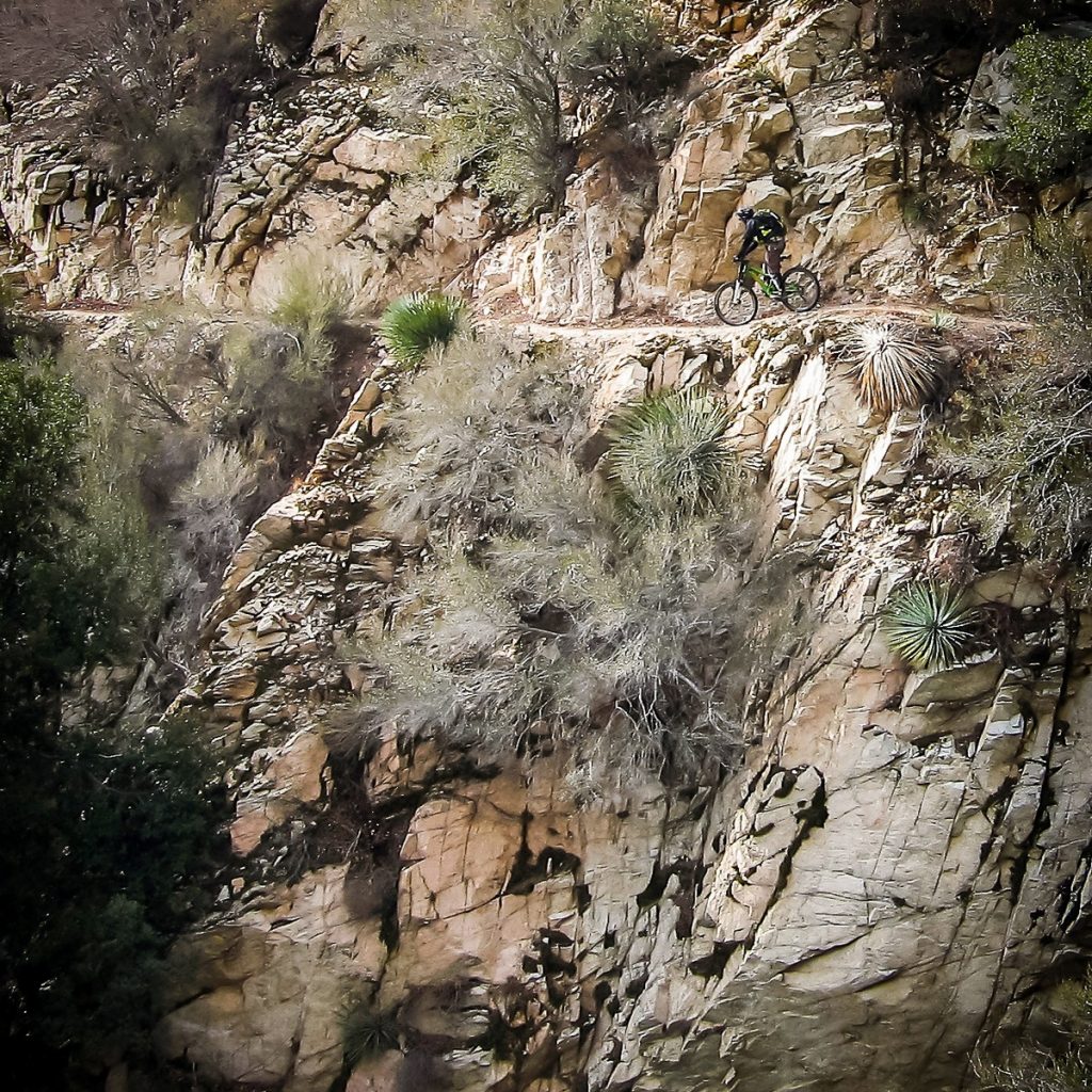
Condor Peak trail is a steep, exposed and challenging backcountry trail.

For mountain bikers, Condor Peak trail was not up for negotiation. While we support protecting the character of the area, we wanted to ensure not only that bicycles could continue to access it, but also that mechanized maintenance (using chainsaws or other powered tools) would continue to be allowed. We’ve seen many trails that have been closed to bikes by Wilderness designations slowly deteriorate as volunteer groups cannot keep up with the existing trail maintenance backlog, and the Angeles National Forest has no trail crew of its own.

The solution we reached was to propose two Wilderness Areas on each side of the trail. The resulting legislation passed last week in the House creates the Yerba Buena and Condor Peak Wilderness areas, separated by a 100′ buffer through which the Condor Peak trail passes. Trail Canyon trail, the only other trail within the proposed Wilderness boundary, is cherry-stemmed out of the Wilderness allowing bicycle access to Trail Canyon falls and the nearby campground. A portion of the upper Trail Canyon trail, which has not been passable by bicycle in decades, will fall within the new wilderness boundary.

CORBA chose not to oppose this latest bill as it had no impact to mountain bike access. However, we could not support it fully, as it does nothing to enhance our mission of improving and increasing trail access for mountain bikes. We remain neutral on the bill, but if it passes, we will remain fully engaged in its implementation to further keep the interests of mountain bikers represented. 

There are two amendments being sought by CORBA and IMBA. Due to what appears to be a mapping error, three switchbacks along the Mt. Waterman trail dip a few dozen feet into the Wilderness area.  Though the Forest Service manages it as a non-wilderness trail, an amendment to the bill, by inserting “fifty feet south of the Mt. Waterman Trail” into the legal description of the wilderness area boundary, would correct that. 
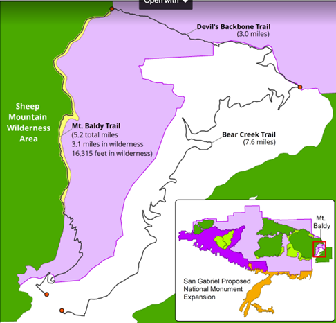
Proposed Boundary Adjustment

Proposed Boundary Adjustment

The other amendment we are seeking is more challenging. The eastern Boundary of the Sheep Mountain wilderness passes directly over the summit of Mt San Antonio (AKA Mt. Baldy).  It is the only one of three peaks in Southern California over 10,000′ and above treeline to which bicycles have access (via the Devil’s Backbone trail). Wilderness advocates wanted to expand the Wilderness boundary eastward, entirely enveloping the Bear Creek trail in Wilderness.  The trail follows the Wilderness boundary, lying just inside the boundary by 25 yards. The trail would completes an incredibly challenging, high-elevation, backcountry loop. We are seeking an amendment to move the boundary 75′ west of the trail, removing it from wilderness, and opening the loop to bicycles. The boundary remains unchanged in the current legislation. 

These two amendments would remove approximately 75 acres of existing wilderness in a bill that adds over 31,000 acres of new Wilderness. These will be difficult asks for some, but we feel the ride loop this boundary adjustment would create a truly unique experience that is attainable nowhere else.

National Monument Expansion

The bill also expands the boundary of the San Gabriel Mountains National Monument, which was declared in October 2014. The boundary expansion makes sense geographically, as one of the biggest challenges in developing the current Monument management plan (as a Forest Management Plan Amendment) was the allocation of district-specific resources.

The Forest Service felt growing pains as they transitioned from three districts to one district and a National Monument (which is managed as a district). The Monument designation left out the most historically significant and most visited section of the Angeles National Forest, which includes the front country trails south and west of Mt. Wilson, and Mt. Lukens, and areas south of Big Tujunga. There was confusion among Forest Service staff when a vehicle, for example, was assigned to the district, but was stationed physically much closer to the Monument. It has taken years, but those challenges have been largely sorted out.

This time around, the bill requires the development of a management plan within three years (the plan amendment for the SGMNM took almost four years to complete). The current Monument designation had no impact to trail access for mountain bikes, and has brought in some additional funding and additional attention to our local mountains. In fact, IMBA and CORBA worked closely with the White House in 2014 to ensure that mountain biking was specifically mentioned in the monument proclamation ensuring its future acceptance. As a result, visitorship has steadily increased since the 2014 designation.

San Gabriel National Recreation Area

The third section of Chu’s bill will create a new National Park Service unit in the San Gabriel Valley. The San Gabriel National Recreation Area would become a new unit of the National Park service. It would comprise land along the foothills of the San Gabriel Mountains and corridors along the San Gabriel, Rio Hondo, and other rivers and open spaces in the San Gabriel Valley.

The proposed NRA would not change any land ownership, nor restrict any current land owner from managing their land (and their trails) as they are already doing. It allows willing landowners or land managers within the NRA boundary to partner with the NPS to improve recreation, habitat connectivity, water quality, wildlife corridors and public access. It doesn’t change any existing trails, and has the potential to bring additional federal resources to local projects.

With all these aspects of the bill, our biggest concern is that the agencies managing lands the bills protect are not adequately funded at a level necessary to do their job effectively. Creating additional financial obligations by the Forest Service and National Park Service, when current budgets are falling short, will bring its own set of challenges.

H.R.3820 has a companion bill in the Senate, S.1109, introduced by Senator Kamala Harris. We will continue to work towards those amendments in the Senate version of the bill, which will face a tougher challenge under the current administration. If the bills fail this year, we expect them to be reintroduced in future sessions of congress.

A fact sheet from Judy Chu’s office can be found at https://chu.house.gov

Rim of the Valley Corridor Protection Act

H.R.1708 was introduced by Congressman Adam Schiff, after several years where similar legislation failed to make it out of committee. The Rim of the Valley Corridor Preservation Act will expand the boundary of the Santa Monica Mountains National recreation area. The expanded boundary will include the mountains surrounding the Santa Clarita, San Fernando, Simi, La Crescenta and Conejo valleys. These include the Santa Susana Mountains, the Simi Hills, the Verdugo Mountains, and other adjacent lands and river corridors as shown below.
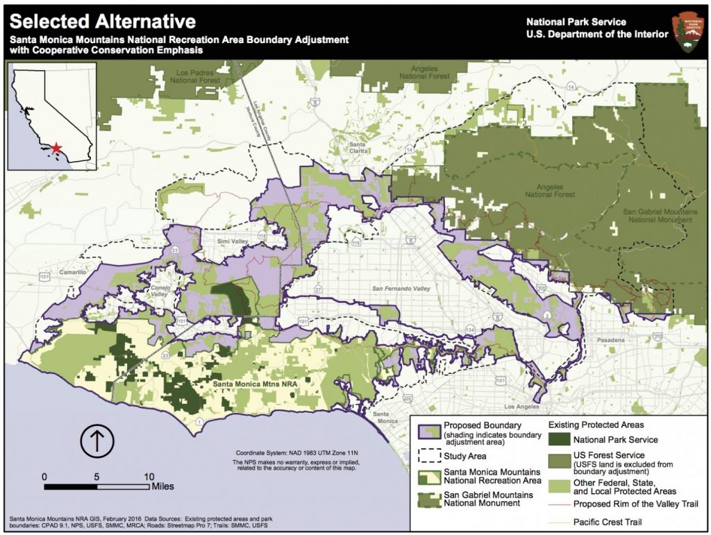
Rim of the Valley Corridor Map

The act does not change the current management of any land or trails within the expanded boundary. What it will do is allow willing landowners or land managers to partner with the NPS on projects that may enhance recreational access, improve habitat and wildlife connectivity, or provide capital improvements. It does not take land away from any existing landowners, nor does it force existing land managers to partner with the National Park service in any way. It has no downsides for mountain biking, and has the potential to improve trail access.

CORBA’s original mission statement and our operational boundary was defined as “the Rim of the Valley Corridor.” This bill is therefore very much at the heart of CORBA’s mission.

The bill was the outcome of a six-year feasibility study, authorized by an act of Congress in 2008. The study began in 2010, with CORBA engaged throughout the six-year process, attending public meetings, providing expert testimony and public comments, and encouraging public discourse and engagement in the process.

The study sought to determine if the area possess nationally significant natural or cultural resources; whether it is it a suitable and unique addition to the National Park System; whether it is feasible to add it to the Park System; and does it require direct NPS management, instead of stewardship from other groups or a public-private combination? The answer to the first three questions was Yes. Since the study concluded in 2016, legislation has been introduced twice without success. Last week the bill passed the House. In December, the Senate Committee on Energy and Natural Resources passed the Rim of the Valley Corridor Preservation Act, moving it one step closer to the Senate floor.

We are fortunate in Southern California to have one of the most mountain bike friendly NPS units in the country, the Santa Monica Mountains NRA. Currently all National Park service managed singletrack trails in the Santa Monica Mountains are open to bicycles. In fact, the only trails closed to us are closed by the Boney Mountain State Wilderness, and California State Parks. We expect the NPS to continue supporting a multi-use trail policy in the expanded NRA. In fact, all of the land managers within the expanded boundary, with the exception of the City of Los Angeles, are multi-use friendly.

Lands within the Angeles National Forest are specifically excluded from the expanded NRA. The Forest Service and the National Park Service already have an arrangement in which they are able to share resources for the benefit of our public lands under the Service First authority, which was made permanent in 2012.

For these reasons we are supportive of the expanded boundary of the Santa Monica Mountains NRA in the current legislation. However, to our knowledge there is no additional budget allocated to the expanded NRA, nor to the new San Gabriel NRA in Chu’s bill. For these reasons we have been reluctant to throw our full support behind the bills as they can be considered unfunded (or underfunded) mandates. If these bills pass, we will advocate for increased funding, and will remain engaged with land managers in the development of their management plans, and to identify opportunities for creating or improving multi-use trails and mountain bike access.

The Rim of the Valley trail was originally envisioned by Marge Feinberg in the 1960s as a trail that encircles the San Fernando Valley, connecting communities with their local mountains. The trail itself is being piecemealed together as opportunities present themselves. The vision of a trail led to a broader vision to protect the mountains surrounding our valleys, and ultimately to H.R.1708. It has been a forty-year effort to protect the mountains that define our valleys.

A fact sheet on the bill can be found at https://schiff.house.gov

SMMNRA Visitor Survey Results Released

Thursday, January 30th, 2020

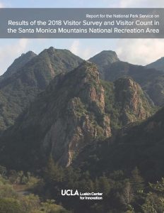
This week UCLA’s Luskin Center for Innovation published the Santa Monica Mountains National Recreation Area Visitor Survey results. This new report builds upon previous visitor surveys and user counts, conducted in 2002. The data are needed to help guide management of the SMMNRA. A Briefing on Diverse Park User needs is also available.

Of specific interest to mountain bikers, is that this data will be used to inform and refine the ongoing Santa Monica Mountains Interagency Trail Management Plan development, which will help guide the respective agencies’ management of existing trails and construction of new trails. The Trail Management Planning process began in 1998. You read that correctly, 1998.

CORBA has for years been advocating for a change in use of trail designation in State Parks, where mountain bikers have the least singletrack trail access relative to the trail miles available to hikers and equestrians. CORBA has a list of trails we’ve formally requested to undergo a change in use. The State’s own policy requires them to respond to these requests. These changes are needed to improve connectivity, decrease congestion on some crowded trails, and further disperse recreational cycling. Our change in use requests date back to the 1990s, and not a single trail has undergone a change in use in that time.

California State Parks underwent a multi-year, multi-million dollar Programmatic Environmental Impact Report to supposedly streamline the change in use process. So far, the only outcome of that study was to retrofit the Tapia Spur trail–which was already open to bicycles–with pinch points, implemented so poorly that all but expert cyclists have to dismount to negotiate some of them.

State Parks have told us to wait for the Trail Management Plan to be completed, which will supposedly identify trails suitable for a change in use to allow bicycles. They have been telling us that for more than 15 years.

While we welcome the report, the surveyors acknowledge that cyclists and equestrians were the least likely to stop and take a survey. The report states that mountain bikers were the 3rd most observed user type in the visitor count, at only 7.7% of visitors. It’s important to note that the survey is of park visitors, not necessarily trail users. It includes respondents who were not necessarily there for trails, but were counted as hikers since they were on foot.

Due to this, and since the survey sites included many trails not open to bicycles, the results seem skewed to undercount cyclists. Any mountain biker or gravel grinder can attest that on trails where bicycles are permitted, bicyclists account for much more than the 7.7% of users reported in the survey. The report states that mountain biking participation has decreased from the 2002 survey. We know this is not true.

It isn’t surprising that 75% of mountain bikers who took the survey were male. That’s an improvement over the 86% male participation in 2002, but we’ve still got a long way to go.

Another important aspect of the survey are the demographics of park visitors. The data highlight social inequities in who has access to the park. The survey acknowledges LA County’s Park Needs Assessment, and corroborates some of that study’s findings. A majority of visitors were higher income, caucasian, educated, and english-speaking. It’s clear that the economically disadvantaged, and non-english speaking populations are far less likely to visit the National Recreation Area, and have a more difficult time doing so. They travelled further, and spent more time to get there.

CORBA’s Youth Adventures program is one way that we are helping to counter that inequity. About twice per month, at-risk youth who would otherwise have no access to the National Recreation Area are taken on a guided interpretive mountain bike ride.

The release of the survey results is an important step forward. Even with it’s acknowledged flaws and perceived inaccuracies, it is needed to guide all park infrastructure development, not just trails. For that we must continue to wait for the Interagency Travel Management Plan. After 22 years we’re hoping to see that plan sometime this decade.

Glendora Seeks Public Input on Little Dalton Wash Multi-Use Urban Trail

Tuesday, September 24th, 2019

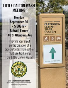
The City of Glendora invites you to a public workshop held in conjunction with a proposed grant application to the California Natural Resources Agency under Proposition 68.  The City is proposing to submit an application for the Little Dalton Wash. The project would construct a bike/pedestrian path similar to the existing Glendora Urban Trail and extend from Finkbiner Park to just south of the spreading grounds near Glendora Mountain Road. The City will be holding a workshop to solicit input and feedback on this exciting opportunity to create and enhance open space, trail connectivity, and recreational opportunities for Glendora, on Monday, Sep 30th.

CORBA supports the proposal, and we encourage everyone with an interest in the Colby trail, the city of Glendora, and its urban trail system to participate in the public meeting:

Little Dalton Wash Meeting
Monday, September 30, 2019, 5:30 – 7:30pm
Bidwell Forum, 140 S. Glendora Ave, Glendora, CA