Archive for the ‘Regions’ Category

Rogers Road Trail Update

Monday, November 15th, 2010

On November 10, CORBA Board members Mark Langton, Jeff Klinger, Hans Keifer, Danusia Bennet-Taber, and Steve Messer, along with Jim Hasenauer of IMBA and Bryan Gordon of the Canyonback Alliance, walked/rode the upper section of Rogers Road Trail with Topanga Sector Superintendent Lynette Brody and Maintenance Supervisor Dale Skinner.  This tour was arranged by CORBA with these State Park employees in response to intense public input regarding recent work performed on the “re-route” (singletrack) section of trail (west where it meets Temescal Ridge Fire Road) as well as about a mile and a half of the wider road bed to the east of the singletrack. In the past few weeks, Supervisor Skinner has used a Sweco trail tractor/dozer to fix and install several drainage channels, as well as bring the trail up to vegetation clearance guidelines for multiple use, specifically, equestrians. Many local trail users have complained to State Parks that the work was overdone and that a once narrow, serene singletrack trail has been obliterated into a road.

There are actually two separate sections, the “re-route” which was built as a true narrow trail, and the main Rogers Road Trail, which was originally a road cut that supported wide and heavy equipment.

Earlier comments on CORBA’s web site began by trying to assuage concerns of trail users not familiar with this kind of work by saying that typically trails “come back” to a more natural state after a couple of seasons. This can be said for the “re-route” section, although CORBA noted to Supervisor Skinner that the widening created a “faster trail” and suggested that possible speed control devices such as pinch-point structures be considered.

As for the wider section, based on the tour that took place on November 10, CORBA’s original comments were premature. After witnessing the complete section of the work area and hearing comments made by Supervisor Skinner, as well as an evaluation by professional trail contractor Hans Keifer, it is evident that the work that was performed lacked forethought and consideration for minimal impact. In fact, no Project Evaluation Form (PEF) was submitted for this work and therefore is in direct violation of the department’s own policy. We were assured by both Superintendent Brody and Supervisor Skinner that the work will not continue until a Project Evaluation Form is completed and that trail users will have a say in the process, which they said could take several months to over a year.

It’s true that after new construction or trail maintenance, trails look bare and lose their natural character.  Typically, Spring rains create new vegetation which helps the trails recover some of their more natural character.   This has been our experience on several agency trail maintenance projects in the past.  In the case of the recent work on the wider section of Rogers Road Trail there was a fundamental disagreement between the State’s position that Rogers should be maintained to “road” standards and that vegetation should be cut wider than the 8-foot wide/10-foot high vegetation clearance suggested by multiple use guidelines–and CORBA’s position that Rogers is a trail (the Backbone Trail), not a road; that the 8-foot/10-foot clearance was for new trail construction, not existing trails, and that the trail should be left as narrow and natural as possible while addressing and achieving the maintenance concerns of water drainage and a proper vegetation width for shared use with equestrians.

We acknowledged that this is a multi-use trail that must work for all users and that there are several drainage and maintenance issues that are beyond the scope of handwork.  We demonstrated how anything more than an 8-foot clearance wasn’t necessary for safety or sustainability and that in many cases the clearance that has been done was far wider than eight feet.  CORBA’s position is that this work went too far and urged State Parks to minimize the impact of the maintenance on the only bike-legal singletrack in Topanga State Park.

We were informed that the plan was to continue the work down to the Will Rogers State Historic Park Trail Loop, and we also expressed serious concern about continuing these impacts into what is admittedly an eroded and deteriorating section of trail. Superintendent Brody and Supervisor Skinner reiterated that moving forward, greater evaluation and a full PEF would take place and could take several months to over a year.

Examination of the new/refurbished drains that were installed shows minimal attention to corrected out sloping to facilitate proper drainage; drains were basically cut with only a few passes with the Sweco’s blade and very little additional shaping or contouring was evident. On another section of trail, an entire corner (approximately 250-300 square feet) was scraped clean of vegetation, with the reason for the denudation being “ it’s for the hikers. Hikers like the beautiful views.” This brush clearance ignores the fact that it created a large, bare, disturbed area of unprotected, easily eroded earth that will exacerbate hydro erosion because there is no root system to control runoff. Also, there was no drain installed at the bottom of the hill where water would run to from this bare area. Another section of trail further south was smoothed of ruts and out sloped correctly. However, the width of the tread was increased to approximately 12 feet, far more than what CORBA considers appropriate or necessary.
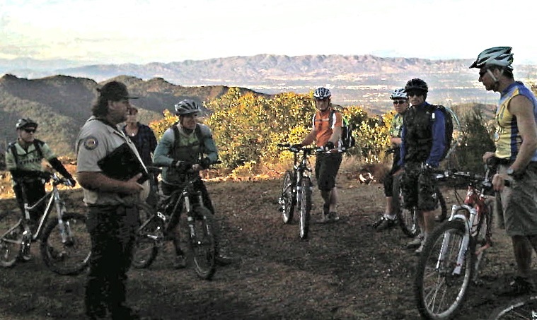
Maintenance Supervisor Dale Skinner (left foreground) and members of CORBA discuss the complete removal of vegetation from dozens of square yards of soil at an "overlook" section of Rogers Road Trail. Photo by Jim Hasenauer

Again, we were assured by both Superintendent Brody and Supervisor Skinner that the work will not continue until a Project Evaluation Form is completed and that trail users will have a say in the process. Check back here for further information as we get it. There will be several opportunities to get involved as trail planning in Topanga State Park and the rest of the Santa Monica’s moves forward. We encourage you to get involved with your parks’ planning process and be proactive in shaping park policy, planning and landscapes.

Saturday’s Rejuvination of the Wood Canyon Vista Trail

Monday, November 15th, 2010

On Saturday, ten mountain bikers and three members of the Santa Monica Mountains Trails Council trail crew fixed the drainage on 0.6 miles of the Wood Canyon Vista (Backbone) Trail in Pt. Mugu State Park, about one third of it’s length. We concentrated on the area that was most likely to be damaged by the winter rain. Running water does by far more damage to the trail than anything else, so we were building rolling dips to get the water off.

Building a rolling tip to divert water that would otherwise run down the trail and create a rut.

While we were working on this trail, a few dozen mountain bikers rode by, mostly downhill but a few were riding up. The vast majority slowed to thank us for our work in keeping the trail in top condition. Sadly, one small group and a few individuals sped through our work area, twice as fast as the other riders, despite our admonitions to slow down. It’s easy to understand why some hikers and equestians don’t like mountain bikers when irresponsible riders are encountered on the trail. Riders like these are the ones everyone remembers, not the great majority who are courteous and respectful to other people. Keep in mind that when you are traveling at say 15 mph down a trail and see hikers coming up and slow to say 5 mph to pass. This may seem really slow to you but to a hiker that is standing still on a narrow trail 5 mph still seems pretty fast.

A couple of riders complained to us that we were “ruining the flow of the trail.” Hopefully they will read this article and come to understand why the rolling dips are built the way they are.

I would like to thank the riders and hikers who came out to help fix up this trail. Everyone did a great job!

Finally, here are the winners of the prizes we had for mountain bikers who came to help out:

– $100 gift certificate for Helen’s Bicycles: Hector Ancheta
– Buff headband: Milind Mahajan
– Ergon grips: Paul Trinkkeller
– Mountain bike inner tube: Charles Cohen

Visit our photo gallery to see the work in progress.

State Parks Programatic EIR Public Hearing

Wednesday, November 10th, 2010

This Saturday, November 13, California State Parks will be hosting the final public hearing on their Draft Programatic EIR.

Bicycle access to trails in the Santa Monica Mountains and many other areas will be directly affected by the final version of this document, so it is important to ensure that mountain bikers are fully engaged in this process. CORBA and IMBA representatives will be attending, and we urge everyone who would like to see more trails opened for bicycles in State Parks to attend and make comments.

What is a Programatic EIR?  This is an effort to streamline the process of converting trails from one designation, such as hiker-only, to another designation, such as multi-use. This is good for mountain biking.  According to IMBA:

California State Park’s Director Ruth Coleman has embraced a statewide Programatic Environmental Impact Report (PEIR) that will improve the process to convert trails to shared-use status. “This will lay the groundwork for the efficient conversion of trails that IMBA California and clubs have been requesting for some time,” says IMBA California’s Tom Ward. This bodes well for efforts to open Bill’s Trail in Marin, as well as numerous trails in Santa Cruz and Humboldt counties, Mt Diablo State Park, Folsom State Recreation Area, Donor Lake State Park, various Sonoma County parks and miles of trails in the Los Angeles basin. According to Ward, park managers have often shown support for improved mountain bike access — but each time they attempt implementation they are threatened with lawsuits from opposing forces. “The intent of PEIR is to curtail the legal challenges to each trail conversion project,” says Ward. He adds, “This is a major milestone for IMBA’s efforts to increase mountain bike access in state parks.”

The meeting will take place from:

1:00 to 4:00 p.m. Saturday, November 13
Lake Activities Building,Lake Perris State Recreation Area,
17801 Lake Perris Drive,
Perris, CA 92571 [map].

The Notice of Preparation for the draft PEIR can be found at http://www.parks.ca.gov/?page_id=980. Public comments are being accepted through November 30. Comments on the PEIR may be submitted in person at the workshops, or by either mail to:

Environmental Coordinator – Trails PEIR
1 Capitol Mall, Suite 410
Sacramento, CA  95814

Or by email to:  ceqansc@parks.ca.gov
(Note:  In the Subject Line, write:  ‘Trails PEIR’)

Comments can also be submitted by Fax to: (916) 445-8883;  Please address faxes to: Environmental Coordinator – Trails PEIR

We’ll have more details and a more thorough report after Saturday’s presentation and hearing.

Trail Work on Rogers Road Trail Halted

Wednesday, November 10th, 2010

CORBA has learned that the recent trail work that has begun on Rogers Road Trail approximately two miles from Temescal Ridge Fire Road (western terminus in Topanga State Park) has been temporarily halted. This has happened in large part to intense input from the public and CORBA, and a request from CORBA for State Park officials to re-examine the necessity and scope of the work before continuing. We have been told by both the maintenance and ranger departments that officials have met internally and are reviewing the protocol and standards for this work. Additional meetings will be taking place this week to determine how and when additional trail work on Rogers Road Trail may take place. At this time it is unclear when the work will resume and at what level, and/or if it will continue the full length of trail to Will Rogers State Historic Park.

Please stay tuned to this web site for further updates.

Mountain Bikers Preserving the Trails

Monday, November 8th, 2010

Sunday’s trailwork on El Prieto went exceptionally well. We had perfectly cool, clear weather, damp soil that was easy to work with, and good spirits all around. Thanks to the approximately 50 people who came out to show this heavily damaged trail some much-needed love.

Rock Armoring Teamwork

Rock Armoring Teamwork

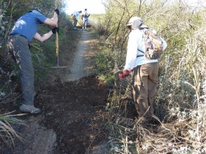
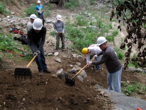
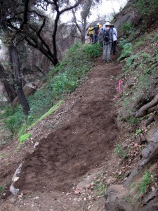
In over 320 person-hours of labor, several washed out drainages were restored, brush was cut back, and many vulnerable sections of the trail tread received rock-armoring treatment. We were even able to restore one section of the original trail that had all-but vanished since the fires. With some diligent hand-tool work and brush cutting, the “cactus corner” section was re-cut and benched, and is ready for finish work.

Special thanks to the St. Francis high school mountain bike team, who came out in force to contribute. Of today’s volunteer trailworkers, more than half were high school team mountain bikers.

As high school students, not only did they learn about trail construction and sustainability, they also gained insight into what makes a “good” trail: how it flows, how it handles water, how sight-lines affect safety on the trail and many other tidbits that one usually doesn’t have time to think about when riding a trail.

Another wonderful aspect of high-school team riders is that many of their parents also get involved. Many are introduced not only to the sport of mountain biking, but to volunteerism and trail stewardship. At least eight parents of high school racers also put sweat equity into the trail on Sunday.

The Forest Service is also requiring all volunteer trail working groups to use safety gear including gloves and hard hats. Thanks to the generous support of REI we were able to outfit all our volunteers with hard hats, a first for CORBA trail crews. We also thank Flat Attack tire sealant for their support of CORBA’s programs.

Special thanks also to Banner Moffat and the Friends of El Prieto, for their ongoing regular work that has helped keep this trail from disappearing altogether since the Station Fire, even though it remains closed to the public. We’re hoping that El Prieto will be a top priority for re-opening by the FS after the rain season ends.

El Prieto trailwork

The original trail restored

Flash flooding and unstable hillsides are still major concerns, and the reason this and many other Station Fire trails will remain closed at least through next spring. In a recent meeting with the non-motorized trails supervisor for the forest, we discussed some creative ways that CORBA, the Friends of El Prieto and other volunteers might work together to open this trail sooner, rather than later. Some possibilities might include a “conditional” opening, where the trail would be closed at any sign of rain, and surveyed after each rain for safety. At this point, the mountain bike community would welcome any access to El Prieto.

Keeping the trail in good shape is the first and most important step towards that goal. Thanks again to everyone who came out!

Elsmere Canyon Now Public Land

Saturday, November 6th, 2010

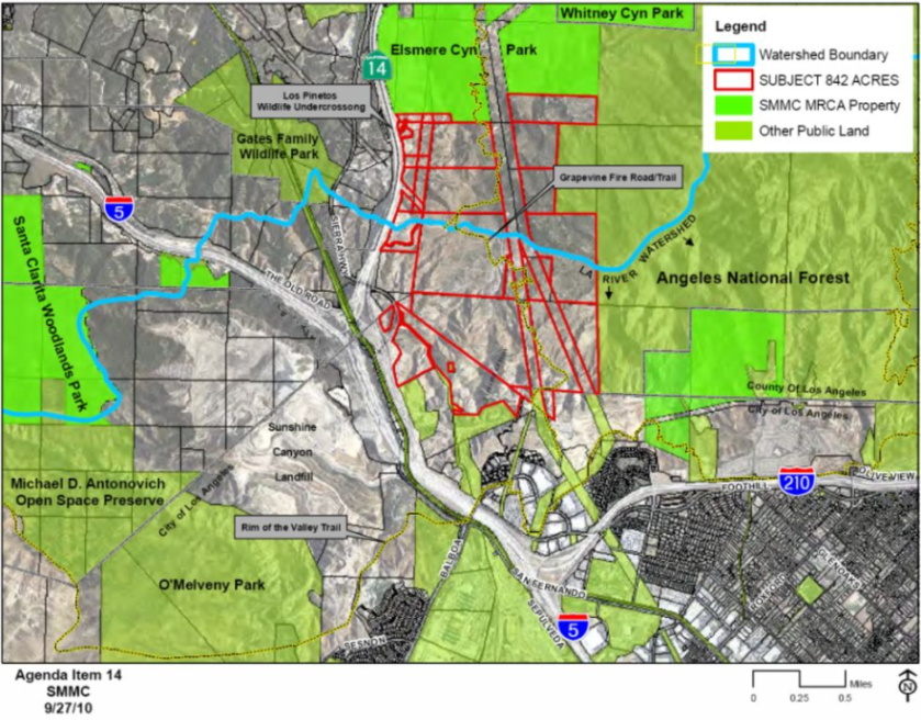
The city of Santa Clarita recently closed escrow on the 842 parcel of land known as Elsmere Canyon. Elsmere was slated to become the largest landfill in Los Angeles during the 1990’s, before Senator Barbara Boxer and Congressman Howard McKeon fought to prevent the devastating landfill project.

Elsmere Canyon Map

(more…)

Giant Sequoia National Monument – Public Comments Extended

Thursday, November 4th, 2010

Many mountain bikers from Southern California venture out to the trails of the Southern Sierras.  Places like Freeman Creek Trail, Quaking Aspen, Camp Nelson and other areas have been enjoyed by off-road cyclists for many years.

Camp Nelson Trail

Camp Nelson Trail, at the heart of the Monument

The Sequoia National Forest is currently accepting public comments on the Giant Sequoia National Monument draft Environmental Impact Statement, which includes several Management Alternatives. This Draft Environmental Impact Statement (draft EIS) describes six alternatives that would amend the 1988 Sequoia National Forest Land and Resource Management Plan to manage the Giant Sequoia National Monument. The draft EIS document will implement President Clinton’s 2000 Proclamation which established the Monument.

Of the six management alternatives presented, Alternative C  could result in a ban for mountain bikes on trails in the Monument, while Alternative D would limit mountain bikes to existing trails without any future expansion. Dispersed camping and other activities are also adversely affected. The remaining options allow for most current trails to be grandfathered in, with varying degrees of flexibility for trail use designations.

We prefer Alternative B, which allows for existing bicycle use and future expansion of recreational opportunities. Alternative F is also favorable to multi-use and bicycles, with the only difference between B and F being the way that fuels reduction and fire control are managed. The complete draft statement is available online for review.

For those who are concerned about California trails being forever closed to mountain bikers, please make your comments to the Sequoia National Forest. This National Monument is bordered by extensive Wilderness areas and a National Park, all of which is off-limits to mountain bike use. We can’t afford to lose more! If you haven’t ridden this area, it offers some spectacular high-country riding and is well worth a visit. It is also very much worth protecting for it’s unique ecological and recreational value.

IMBA is also reviewing the document drafts and will issue their official comments soon.  We encourage everyone to write in support of Alternative B, and strongly against Alternatives C and D. Note that you must login and/or register on the SNF Public Comment Portal to post your comments.

Comments are being accepted through December 3rd, 2010.

Calabasas planning workshops on Las Virgenes Trail Nov 3 & 6

Wednesday, November 3rd, 2010

from the October Newsletter of the Las Virgenes Homeowners Federation

The purchase of “Firehouse Hill” has eliminated a major obstacle to completion of the Las Virgenes Trail, which could some day create a system of bike trails and footpaths along Las Virgenes Creek from Ahmanson Ranch all the way to Malibu Creek State Park, enabling citizens – and especially our children – to walk or ride their bicycles from their homes in Malibu Canyon, Mont Calabasas, Las Virgenes Village, and Deer Springs to Albertson’s, AE Wright, and De Anza Park without having to ride or walk in traffic.

The Las Virgenes Trail will get us out from behind the wheel of our cars, reducing traffic and emissions while giving our kids the badly needed exercise of walking or riding their bikes to school every day along the wooded banks of our local creek.

Calabasas plans to begin the process of planning for the segment of the Las Virgenes Trail from Agoura Road to De Anza Park in two Community Visioning Workshops on the following dates and locations. Children are welcome to attend.

– Wednesday, November 3rd from 6:00 to 8:00 PM at the Calabasas Library
– Saturday, November 6th at the Agoura Hills – Calabasas Community Center

For questions, call Senior Planner Geoffrey Starns at (818)224-1706

Working on the Los Robles Trail West, CORBA’s adopted trail

Wednesday, November 3rd, 2010

Ruts on the trail where a new rolling dip was built

CORBA’s adopted trail, the Los Robles Trail West in Thousand Oaks, wasn’t in very good shape this spring after the winter rains. Long segments were wildly overgrown by mustard and thistle, and some steeper sections had deep ruts. Over the years, the tread of the trail had become U-shaped in cross-section. The natural rims keep rainwater on the trail, where it runs down the middle, taking soil with it and forming a jagged rut.

COSCA hired professional trail workers to fix up the trail in the spring. They cut back the overgrowing weeds and filled in the deep ruts. Unfortunately, they didn’t build water diversions (‘rolling dips’) to keep future rain from running down the trail and reforming the rut. Furthermore, the center of the trail, where the rut had been filled in, was much more loosely packed than the rest of the trail, making it much more susceptible to water erosion.

The rain that we had in the last two weeks of October was enough to start carving new ruts. At the beginning of November, a rut a few inches deep had formed on one of the steeper sections of the trail.

CORBA trail crew members and local residents Danusia Bennett-Taber and Steve Clark spent three hours fixing up the trails. They built two rolling dips on a steeper segment, one near the top and another just above a very steep part. These water diversions will redirect rainwater off the trail so it shouldn’t form another rut. They also filled in the rut on the very steep part at the bottom. Being protected by a rolling dip from above, this rut should not reform once it is packed down by trail users.

View a short photo gallery of the work that was done.

Sullivan Canyon Update November 2010

Wednesday, November 3rd, 2010

From Sharon O’Rourke, The Gas Company

I wanted to give you an update of our Sullivan Canyon Pipeline Protection Project.  The project will take longer than originally estimated due to the recent rains we have experienced.  We originally expected to complete the work sometime by November 12th.  The new estimate for completion is now December 10th, weather permitting.

On August 4th, we started construction to repair the access road and install protective concrete mats over 12 pipeline exposure areas.  These exposure areas make the pipelines vulnerable to damage.  Of the 12 exposure areas, 8 pipeline areas have been inspected, repaired and covered with the protective concrete mats.  We have 4  exposure areas to complete.

Due to on-going pipeline construction activity, public access to Sullivan Canyon remains closed.