Archive for the ‘Regions’ Category

Canyon Trail and Vasquez Rocks – Meeting Thursday July 12

Tuesday, July 10th, 2012

The County’s objective assessments of the Canyon Trail in Placerita Canyon Natural Area, and the Heritage trail in Vasquez Rocks, have been completed.  By applying the State’s Change In Use survey, objective data was gathered about these two trails.

The study concluded that Canyon Trail can be made suitable for multi-use designation including bicycles. It will require some modifications including pinch points, signage, and a designated walk-your-bike section. The trail, irregardless its potential for a multi-use designation, was found to be needing additional trailwork and restoration in several areas. We hope that the modifications needed to allow bicycles can be given priority over other needed trailwork.

Heritage trail, on the other hand, was found to be unsuitable for multi-use designation. The primary reasoning behind this finding is a lack of connectivity to other trails that allow bicycles, and the availability of an alternate route. Extensive impacts were noted from existing users (hikers and equestrians) that would require significant restoration.

While these findings might make sense if Heritage trail were the only candidate for opening to bicycles, there are many miles of trails in Vasquez Rocks. Mountain Bikers from the Santa Clarita Valley did not specifically ask for the Heritage trail to be considered for multi-use, they asked for the Vasquez Rocks Natural Area to be considered for multi-use including all its trails.

In fact, CORBA would like to know what objective data the County’s “no bicycles in Natural Areas” was based. By what process was this policy formulated?

CORBA supports the County’s assessment of the Canyon trail and the recommendation to open it to bikes. We do feel, however, that the assessment of Vasquez Rocks is incomplete as only one trail has been assessed. The fact that the only trail assessed in Vasquez Rocks has seen such significant impacts from existing users, underscores the point that all users have impacts, and bicycles in that respect are very similar to other trail users. We urge the County to complete the assessment of Vasquez Rocks’ trails and to consider future potential connectivity of all trails as a whole.

We also feel that the inclusion of State draft studies should not be cited as evidence until they are fully vetted and published, and the classification of bicycling as an incompatible “active recreation” is inaccurate.

The County will be hosting a public meeting on Thursday, July 12 to formally present the findings and take public comments. There is expected to be a large and organized opposition from other user groups present at tomorrow’s meeting, unlike the first meeting in which mountain bikers made up the vast majority of the attendees. The SCV Trail Users group did a great job of gathering and organizing local mountain bikers during the first meeting, and have continued to provide leadership on these issues, with the full support of CORBA and IMBA.

Please attend this meeting and let your voice be heard:


6pm, Thursday, July 12, 2012. 

William S. Hart Park – Hart Hall  (map)

24151 Newhall Ave, Newhall, CA 91321, USA

Consider RSVP’ing to the SCV Trail Users Facebook event: https://www.facebook.com/events/246695458775275/

Skills Clinic Photos for July 7, 2012

Saturday, July 7th, 2012

It was another beautiful day to be riding in Malibu Creek State Park! Twenty-three riders came out to enjoy the fabulous weather today and participate in this month’s basic skills clinic. This month we skipped the steps. You can see the photos in the July Skills Clinic Photo Gallery. And there was another photographer there for the early part of the session. She was from the local weekly newspaper, The Acorn. Perhaps there will be a photo and article about the class in next week’s edition.

IMBA Trail Care Crew Report from California

Sunday, July 1st, 2012

Most applications requesting Trail Care Crew visits originate from mountain bike advocacy organizations. In the 23 visits we have made, this stop in central California was only the second time that a land management agency — the Georgetown District of the U.S. Forest Service — made the request. It’s something we think the Subaru/IMBA Trail Care Crews will start seeing more of as federal, state and local land management agencies learn how much there is to gain from working with outside partners.

Limited budgets and ongoing funding cuts are a grim reality for many Forest Service districts. Partnerships between land managers and local mountain biking advocacy organizations offer much-needed relief — bike clubs can supply knowledge, experience, volunteer labor and more to help fill the gaps between the vision for new trails and the reality of getting them built.

The Georgetown District staff we met with are excited about what they can accomplish by working with local mountain bike advocacy organizations, including the Folsom-Auburn Trail Riders Action Coalition and the Forest Trails Alliance. The Eldorado has great potential, with good existing trails and the potential to develop some great ones. The nearby trails in Auburn are popular and sometimes a bit overcrowded, so developing the Eldorado’s trail network holds the potential to benefit riders and lessen their impacts by spreading them out over a greater area.
The name “Eldorado” conjures an imaginary place of great treasure and opportunity. Will California’s Eldorado National Forest live up to such a grand definition? We think they are on their way.

— Jake and Jenny

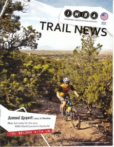
From the International Mountain Bicycling Association‘s quarterly publication Trail News, Spring 2012

Save the date!  CORBA will be hosting the IMBA Trail Care Crew October 18 – 21 later this year.

Youth-Oriented Publication Available Soon, Take A Kid Celebration Slated for Oct. 6

Sunday, July 1st, 2012

With major support from Shimano, IMBA will publish two special editions of IMBA Trail News in 2012. Copies of ITN Youth Edition will be available on IMBA’s online store, free of cost except for shipping fees. These full-color, print magazines will focus on providing resources for adult leaders of youth-oriented mountain bike programs, plus stories, photos and tips that young riders aged 12 to 18 will enjoy reading.
This October, in support of First Lady Michelle Obama’s “Let’s Move!” initiative, IMBA has pledged to get 30,000 children participating in 300 cycling events for the annual Take a Kid Mountain Biking Day celebration. We could use your help in reaching this goal on Oct. 6. Broadcast Take a Kid Mountain Biking Day to your chapter/club networks, host a ride or sponsor the IMBA outreach program.
Since we believe that kids should be on bikes everyday, we’re encouraging all participants to sign up for the Presidential Active Lifestyle Award (PALA), whereby you pledge to be active at least 5 days a week for 6 weeks. Youth (6-17 years) should get moving for at least 60 minutes per day, and adults (18 years or older) should be active for 30 minutes per day. What better way to get active than to be out riding a bike?

From the International Mountain Bicycling Association‘s quarterly publication Trail News, Spring 2012

New IMBA Mapping Program Underway

Sunday, July 1st, 2012

IMBA is proud to launch its long-anticipated mapping project and the IMBA National Trails Database (INTD). The database will offer a GIS-based online resource that documents natural surface, bike-friendly trails. It will also display information related to IMBA programs from the local to the federal level.
The mapping work has only just begun — the ultimate goals include providing dynamic trail maps, trail descriptions, reviews and information about IMBA’s work in map form. The INTD resource will answer questions about where to ride and what trails might be affected by access threats and travel management plans. It will showcase and describe the work being done in the U.S. and around the world by IMBA and its partners, chapters, affiliated clubs and individual supporters.
“Since almost everything we do is location-based, IMBA has a great opportunity to connect people to the world of mountain bike advocacy in a way that’s both graphically informative and visually exciting,” says Leslie Kehmeier, IMBA’s full-time mapping specialist. “From the regions we cover to the members we serve, right down to the trails we ride, the mapping program will further IMBA’s mission to protect, create, and enhance great trails experiences for mountain bikers worldwide.” Pilot projects will include a map of Santa Fe (NM) mountain biking trails prior to the IMBA World Summit there, and maps for each IMBA Epic ride.

From the International Mountain Bicycling Association‘s quarterly publication Trail News, Spring 2012

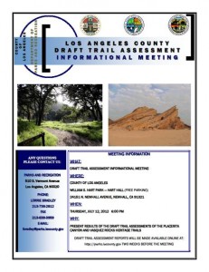
Placerita Canyon, Vasquez Rocks Trails Public Meeting Announced for July 12

Wednesday, June 20th, 2012

LA County Public MeetingThe County of Los Angeles has completed their assessment of trails in Placerita Canyon Natural Area, and Vasquez Rocks.  They have scheduled a meeting to discuss their findings and draft report for:


July 12, 2012, 6 p.m. 

William S. Hart Park – Hart Hall

24151 N. Newhall Avenue, Newhall, Ca 91321

The Canyon Trail was closed to mountain bikes, after having been posted open for several years, in 2011. Mountain bikers came out en masse at the initial public meeting, and we hope for a similar turnout at this next meeting. Los Angeles County has applied the State Parks Change-in-use Assessment tool to evaluate the trails, and will make recommendations based on their objective findings. The State has been actively developing and testing the tool over the past two years. It’s initial test in Southern California was on the Tapia Spur trail. In that case it was found that with some modifications, the trail could be made safe and sustainable for all users, including mountain bikes. Tapia Spur is currently in the process of being upgraded with those recommended modifications. We would hope for a similar outcome in the County’s application of the tool.

The draft report itself will be released on June 28, twelve days before the public meeting.  We will post a notice and a quick review of the report once it is made publicly available.


Santa Monica Mountains Gets a New Visitor Center

Sunday, June 10th, 2012


Saturday, June 9 2012, hundreds of people descended upon King Gillette Ranch for the grand opening of the Anthony C. Bielson Interagency Visitor Center. The new visitor center is in the heart of the Santa Monica Mountains near Las Virgenes and Mulholland Highway. It had been in Thousand Oaks for years, some distance from actual parkland.

The Visitor Center will be managed jointly by the National Park Service, California State Parks, the Santa Monica Mountains Conservancy, and the Mountains Recreation and Conservation Authority.

Several CORBA representatives and volunteers were on hand to enjoy the two-hour ceremony. We were also pleased to see many of the past and present land managers from each agency with whom CORBA has worked extensively. There were many elected officials, representatives of public agencies, conservation and open-space activists. Afterwards the public got their first hands-on with the center’s extensive new facility.

The center is a converted and upgraded barn, and runs off solar energy.  It houses some impressive educational displays, route planning, high-tech touch screen slide shows and a large relief map of the entire NRA. Kids seemed to love the interactive displays. There’s an extensive gift shop and staff eager and ready to help the public get the most out of a visit to the park.

It’s the culmination of a decades long effort by activists, politicians and passionate lovers of the outdoors to protect and preserve the ranch from development. It now stands as a testament to that effort. During the extensive speeches, it became clear that a great many people contributed to this process and project in some way. From a dream to court battles, to acquisition, and now reality. And for all those involved and all of the public, it was a very welcomed day.

The visitor center is on Mulholland Highway, just east of Las Virgenes Road. If you ever need to know anything about the Santa Monica Mountains, plan a trip or just learn about nature, it’s definitely worth a visit.

More photos below the break.

(more…)

Angeles National Forest Land Management Plan Ammendment Comments

Friday, June 8th, 2012

We recently put out an alert  about court-ordered changes to the Land Management Plans for our four Southern California National Forests. We’ve now attended the public meetings, pored over maps and GIS data and have put together our official comments on the plan, available as a PDF, and copied below.

IMBA has recently put out an action alert and petition to preserve mountain bike access to all existing multi-use trails in our four National Forests. We encourage everyone to sign the petition.

In the Angeles National Forest the only area in which we see the potential for problems is the proposed change of the Salt Creek and Fish Canyon Inventoried Roadless Areas into the combined Fish Canyon Recommended Wilderness (RW).  The Golden Eagle trail is an extremely popular, well-documented trail used frequently by bicycles. It is not on any forest service maps and is not an offiicial forest service trail, though it has existed for at least 25 years. We would of course like to see this brought into the trail inventory, and excluded from any recommended wilderness. The trail lies outside the RW, except for one section where it is impossible to tell from the data supplied whether it touches the RW boundary, or crosses it.  We would like to see the boundary adjusted to provide a reasonable buffer between this trail and the RW.

Similar incursions into or across the RW boundaries appear to occur on the fire roads to Knapp Ranch and Atmore Meadows. They are probably just anomalies of the scale of maps used and data supplied, but must be clarified to be sure these fire roads are outside any RW.

The RW includes several miles of singletrack trails that have a history of bicycle access. These include the Burnt Peak Canyon trail and Fish Canyon trail. However, both of these trails are in a dilapidated state and have seen very little use by bicycles, or other users for that matter. In his 1990 guidebook to the area, Mike Troy describes the Fish Canyon trail (16W05) as a difficult hike a bike and the trail as unmarked and difficult to follow. The Burnt Peak Canyon trail, on the other hand, is described as a fun, non-technical double-track.  We will endeavor to gather more data about the existing conditions of these trails, but for the moment we are asking that they be left as Backcountry Non-Motorized (BCNM) rather than RW.

While we support the ongoing preservation of our remaining open space and prevention of future disruptive development or extractive use of the land, trails are a limited resource and losing trails reduces our future options for recreational access. A RW designation will make these trails more difficult to restore or maintain, and we risk losing them forever.

We encourage everyone to send comments via email to socal_nf_lmp_amendment@fs.fed.us or snail mail to: Attn: LMP Amendment, Cleveland National Forest, 10845 Rancho Bernardo Road, Suite 200, San Diego, CA 92127-2107.

CORBA’s submitted comments follow the break.


(more…)

California Bicycle Access Threatened

Wednesday, June 6th, 2012

ALERT! Mountain bikers stand to lose treasured backcountry riding experiences in Southern California’s national forests.

Take Action! Let the U.S. Forest Service (USFS) know that you support IMBA’s position to protect mountain bike access. We made it easy, just sign our petition (click on Take Action! at the beginning of this paragraph). Comments are due Mon., June 11.

In the four Southern California national forests: Los Padres, Angles, San Bernardino and Cleveland the USFS is currently planning for management of their backcountry lands. In order to maximize riding opportunities and not lose mountain bike access to trails, it is imperative that you ask the USFS to use a “Backcountry Non-Motorized” designation.

The plans for these forests will decide where mountain bikes are allowed and where we are banned. Their current proposals include “Recommended Wilderness” (banned) and “Backcountry Non-Motorized” (allowed) designations.

In several previous decisions, the USFS decided to manage “Recommended Wilderness” as if it were congressionally designated Wilderness. IMBA strongly objects to this policy.

IMBA needs your help to maximize the riding opportunities in these great forests.

Read more about the project.

Skills Clinic Photos for June 2, 2012

Sunday, June 3rd, 2012

Many thanks to Graham Martin who took over taking photos from Steve this month, who had another commitment for National Trails Day. It started off overcast but cleared for another beautiful day to be riding in Malibu Creek State Park! About 10 riders came out to participate in this month’s basic skills clinic. You can see them in the May Skills Clinic Photo Gallery.