Archive for the ‘Environment’ Category

Sullivan Canyon Closure Update August 11

Monday, August 11th, 2014

From SoCal Gas:

Sullivan Canyon will be closed to visitors Tuesday August 12th for a Hydro-Static Pressure test of the natural gas transmission pipelines. Please schedule your visit accordingly.

This closure if for safety reasons so please do not access the canyon from any of the side trails. The canyon will be open again on Wednesday provided there are no problems with the test. Please use caution as you pass construction equipment, and we recommend keeping dogs on a leash so they are not harmed by equipment as well.

For information, contact:

Mike Harriel

Public Affairs Manager

Regional Public Affairs

555 W. 5th St.

Los Angeles, Ca. 90013

Office: 213 244-4633

Sullivan Canyon Work Update, July 3

Thursday, July 3rd, 2014

The latest news from Mike Harriel of So Cal Gas regarding construction as they move closer to the mandated test on its pipelines in Sullivan Canyon.

Beginning July 8th

·         We will conduct a bird survey to determine if any nesting birds are in the area of our work. If there are, the project will be delayed.

·         If all is well with the nesting birds, we will work with a certified arborist to trim trees that could sustain damaged by construction equipment. The trimming will occur at the direction of the arborist and only the minimum necessary.

·         An active beehive will have to be removed for the safety of our employees and users of the canyon.

 Beginning July 14th

·         Construction mobilization will occur. You will notice the moving in of water tanks and other construction equipment. Tanks and equipment will be staged away from the trail. All soil will be returned to the excavation it is removed from.

·         A fire prevention plan is in effect to protect the canyon.

 As mentioned previously, the canyon trail will remain open. Signs will provide advance notice when the canyon is closed for hydro testing, which will occur over the course of one day. Signs will also be posted at the drop-in trails. For safety reasons, we don’t want any members of the public dropping in to the canyon during the test, so please abide by the posted closing.

As always, if you have any questions or comments, please don’t hesitate to contact me.

Mike Harriel

Public Affairs Manager

Office: 213 244-4633

More Work Scheduled for Sullivan Canyon in June

Wednesday, May 28th, 2014

Since 1960, Southern California Gas Company (“SoCaIGas”) has owned much of the land that comprises Sullivan Canyon (more than 4 miles in length).  This property is used as a corridor for two transmission pipelines that provide Los Angeles residents with a safe and reliable supply of natural gas.  Periodically, SoCalGas must perform maintenance on these pipelines. The purpose of this letter is to provide information on pipeline maintenance and repair work that will occur in the coming weeks.

SoCalGas will conduct a hydrostatic pressure test on a segment of one of our natural gas transmission pipelines in Sullivan Canyon.  Hydrostatic pressure testing is a process that uses water to exert pressure on a pipeline at levels greater than its usual operating pressure to assess its soundness, often referred to as its integrity.

This test involves digging around the underground pipeline and safely venting natural gas from the pipeline. We will then fill the pipeline with water, and increase the pressure to a level that is higher than the pipeline’s normal operating pressure.  If the pipe holds the pressure without any leaks, it will be put back in service. If the pipeline leaks during the test, SoCalGas will repair the pipeline and retest it, or replace it with new, pre-tested pipeline.

What to expect

The construction work will take place at several locations starting west of the Sullivan Canyon trailhead at the end of Queensferry Road and about a quarter-mile northwest of the trailhead.  Work will begin in June 2014, and last about four to six weeks, although weather and other factors affecting safe working conditions could change the schedule. Normal work days will be Monday through Friday 7:00 a.m. to 7:00 p.m., however, some activities may extend the hours.

Test Start Location:

At Sullivan Canyon Trailhead at Queensferry Road, a test-start location will be staged just west of the trail with an excavation site, water tanks, and other equipment. This area will be closed to the public.

Test End Location:

About a quarter-mile northwest of the trailhead, a test-end location with excavation site and support equipment will be staged alongside the trail.  This area will also be closed to the public.

Hikers, bikers, and others traversing the trail should use caution while passing by both test site locations. For safety reasons, Sullivan Canyon Trail will not be accessible by the public on the actual test day for the duration of the test. Check local signage with updates on construction activity.

The local community may notice truck traffic bringing test equipment and water tanks to the test sites and then removing them. Nearby residents may hear some work-related noise.

Your gas service should continue without interruption. If that changes, a SoCalGas representative will contact you.

The odor of natural gas

At times, you may smell the odor of natural gas and hear a loud, steady noise as we vent natural gas from the pipeline using safe and common techniques. Although this is normal when crews are working, we encourage anyone who has concerns about the smell of gas to call us from a safe location at 1-800-427-2200. We are available 24 hours a day, seven days a week.

We apologize for any inconvenience while we’re performing this test and appreciate your patience and cooperation.

Mike Harriel

Public Affairs Manager – Southern California Gas Company

Tel: (213) 244-4633 

Sullivan Canyon Officially Re-opens

Wednesday, March 19th, 2014

image001By Mike Harriel, Southern California Gas Company

So Cal Gas has completed mandated maintenance work on the pipelines in Sullivan Canyon. The canyon is now open for use.

As I have mentioned before. There is another maintenance project occurring in the canyon in early May 2014. I will inform you about the impact to the canyon as well as timeline once I have all the information.

Please be aware; at the end of the Sullivan Fire Road north of Mulholland Drive, Southern California Gas Company (SoCalGas®) will soon be working in the area to perform a pressure test on one of our natural gas pipelines. You will see SoCalGas and its Contractor’s trucks, water tanks, and heavy equipment.

I know a lot of you use this road for hiking and biking. My understanding is the road will not be completely blocked so you will be able to pass through. Work will begin late March 2014, and last until approximately early in May 2014, although weather and other factors affecting safe working conditions could change the schedule.

Thank you for your patience regarding Sullivan Canyon closures. Please understand Sullivan Canyon is private property, owned solely by the southern California gas company. Its primary function is a corridor for two high pressure gas lines. Because of its natural beauty, we make it available for public use. Periodically, we must complete state and federally mandated maintenance on this pipeline to insure its integrity and public safety. This maintenance may require partial or complete shutdown of the canyon, depending on the nature of the work. We try to keep the public informed of this work, scheduling and user impact.

Please let me know if you have any questions.

Happy hiking and biking!


LA County: Santa Susana Mountains Trails Master Plan Update

Wednesday, March 12th, 2014
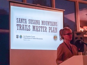
Santa Susana Mountains Trail Master Plan Meeting

Kathline King introduces the SSMTMP

At last weeks second public meeting on the Santa Susana Mountains Trails Master Plan, the County presented a comprehensive map showing their planned trails, the existing trails, and the relevant delineations of private, public and utility lands. While public comments were made, they weren’t being recorded.

CORBA would like to express our sincere thanks and gratitude to L.A. County Parks and Recreation Planning Division staff for moving this trail plan forward, and to Supervisor Antonovich for his support of the process. CORBA whole-heartedly supports project, the process, and the deliverables (maps) presented at the meeting last week.

In looking at the final draft map, we were pleased to see that the agency had listened to the prior comments asking to expand the study area so that true connectivity between disparate open spaces and existing trails could be explored more thoroughly and with a more regional view.

From our cursory review of the maps presented at the meeting, we can say that the work that has gone into this planning effort has been very much worthwhile. We feel the document is a great step towards achieving the stated goals of identifying missing links, providing connectivity between existing trails, open spaces and jurisdictions, and recognizing the value of some of the existing non-system trails. We feel the eventual implementation of the plan will increase both the quality, quantity, and variety of recreational experiences the community so badly needs.

We are also sensitive to the concerns of private property owners who expressed feelings that they hadn’t been heard. However, we also feel that many of their concerns arose from an incomplete understanding of the goals of this planning process. In some cases, it seemed their negative experiences with other neighboring public land managers have elevated their concerns about dealing with the County. We hope that as the plan is implemented and negotiations take place with private land owners (and the neighboring public land managers), their fears can be allayed and mutually beneficial compromises reached for the benefit of the entire trail user community and the public-at-large.

The County’s policy favoring shared-use trails including bicycles is very important to us as a trail advocacy group comprised of bicyclists. We know that there are several places where proposed County trails will connect to trails in City of Los Angeles parks such as O’Melveny and Limekiln Canyon. On these City trails bicycles are presently prohibited. It is our hope that the County and City can come to a compromise that would allow bicycles to connect legally to the proposed County trails/trailheads that are only accessible through City property and trails.

Since this Trail Master Plan will be incorporated into the County General Plan, we feel it would also be worth coordinating proposed trailheads with the 2012 L.A. County Bicycle Master Plan. Having trailheads accessible by bicycle-friendly infrastructure such as Class II Bike lanes is good for encouragement, makes them more accessible to non-drivers, and helps reduce vehicular traffic to trailheads.

CORBA is at present in full support of the plan. It will be presented to the County Rec and Parks Commission later in the year, and subsequently to the L.A. County Board of Supervisors for adoption.

Update March 16, 2014: The plan will be presented to the Planning Commission on March 26, 2014. Meeting starts at 9 am at the Hall of Records Room 150, 320 W. Temple Street, Los Angeles, California 90012. The Parks and Recreation element is agenda item #6.i.

The Trail Master Plan map and powerpoint presentation are available on the County’s web site.

Update, March 26, 2014: The LA County Regional Planning Commission held their hearing on the draft plan today. Steve Messer, Jim Hasenauer, Ken Raleigh and Tony Arnold all testified in support of the plan. One private landowner, and five equestrian representatives also testified in support of the plan, all of them mentioning multi-use trails. Nobody spoke against the plan. Other elements of the County General Plan were also presented to the Commission, who held the matter over until their next meeting in April. We are confident the Planning Commission will approve the plan, which will then go before the Board Of Supervisors later in the year.

Sullivan Canyon Pipeline Work Begins January 6

Friday, December 20th, 2013

From the Public Affairs Office of Southern California Gas:

Since 1960, Southern California Gas Company (“SoCaIGas”) has owned much of the land that comprises Sullivan Canyon (more than 4 miles in length). This property is used as a corridor for two transmission pipelines that provide Los Angeles residents with a safe and reliable supply of natural gas. Periodically, SoCalGas must perform maintenance on these pipelines. The purpose of this letter is to provide information on pipeline maintenance and repair work that will occur in 2014.

Purpose of this Work

We recently internally inspected our pipeline. By code, we have areas we are required to perform a visual inspection of the pipeline as part of a validation process. This work is required to maintain the pipeline’s safety and integrity.

Location and Logistics

There are two work areas along the access road within the canyon that will require excavation.

Location 1: 0.7 (seven tenths) of a mile south from fire road #26 at the Mulholland entrance

Location 2: 2.8 miles in from fire road #26, or 1.4 miles from the Queensferry entrance

Partial Canyon Closures

The Canyon path will be closed from the Mulholland entrance at fire road #26 to location 1.

There is no change to the Queensferry entrance. Signs will be posted along the path indicating construction status.

The following impacts are to be expected in the canyon and surrounding neighborhood. I will keep you apprised of any changes.

-Work will commence on or about January 6, 2014.

-Work is estimated to be completed in 8 weeks.

-Information signs will be posted in advance at the beginning of each entrance.

-Work hours are sun up to sun down, Monday through Friday. No work will be performed on Saturday and Sunday.

-Intermittent loud noise in the immediate work areas.

-Increased dust in the immediate work areas.

-Increased traffic at the Mulholland entrance from work crews and equipment.

SoCalGas appreciates your understanding and apologizes for any inconveniences caused by this necessary work. It is our goal to minimize disruptions. We value our relationship with the community and will communicate with you when our work has the potential of impacting our neighbors. Again, there are two high-pressure transmission pipelines located in the canyon and we will continue to periodically perform maintenance work to them as-needed to ensure safety.

Safety is our first priority. Should you have any questions, please call me 213 244-4633 or email me at mharriel@semprautilities.com.

Sincerely,

Mike Harriel

Public Affairs Manager

What CORBA Does

Wednesday, October 30th, 2013

By Mark Langton

Bikes, horses, hikers and runners

Bikes, horses, hikers and runners. We all love trails.

Recently a bicycle club-team representative  contacted CORBA wanting to see what more they could do to get more of the trails that are currently closed to bicycles opened up to shared use. A couple of comments from the correspondence were that they thought that showing up in larger numbers to public meetings would help, and that they thought the main reason that trails were closed were because of an influential public anti-bicycle lobby.

I wrote back to the person who contacted me, and in doing so came up with what I think is a good overview of what CORBA has been doing for the past 26 years, and continues to do on behalf of all public backcountry trail users (see below). Yes, CORBA is a mountain bike organization, but we are more than that, and here’s why: We believe that shared use works better because it disperses use, rather than concentrating it. When you disperse use, you reduce congestion, and when you reduce congestion, you reduce confrontation. Moreover, it has been shown that where shared use trails exist, it works. Maybe not perfectly, but certainly better than where there are restrictions to bicycles, because shared use also fosters cooperation. Bicycles do mix when operated considerately and with the safety and serenity of other trail users in mind. And that’s the crux of the issue: If bicyclists would simply slow down around others, including other bicyclists, they would be solving the problem of both dangerous speed, and the “startle factor,” or the disruption of another’s peaceful enjoyment of the backcountry.

Here’s what I wrote to that bicycle club team member:

This year CORBA celebrated its 26th anniversary. In that time we have made many strides to opening trails to shared use (hiking, equestrian, bicycle) in the Santa Monica Mountains National Recreation Area, Angeles National Forest, Los Angeles County, and Eastern Ventura County. We have participated in hundreds of public meetings with land managers over the years. Land managers recognize and continue to adapt to the growing bicycle population and changing demographic profile of the trail user community. They are certainly aware of the needs and desires of the mountain biking community through CORBA’s efforts, which include quarterly meetings with principal agency managers (National Park Service, State Parks, Mountains Recreation and Conservation Authority). We are also in constant communication with these agencies and/or when the need arises to address a specific issue. CORBA also works closely with the Mountain Bike Unit which aids the rangers and community with safety and education. CORBA also schedules and organizes regular trail maintenance work days s in conjunction with the Santa Monica Mountains Trails Council and Conejo Open Space Conservation Agency. CORBA is also heavily involved with the Angeles National Forest with trail maintenance and volunteer patrol participation. Due to CORBA’s efforts, most of the singletrack trails built in the last 25 years are shared use (not to mention a lot of the singletrack that already existed not getting shut down).

 As you can see, there is more to getting involved than just showing up at meetings in large numbers. The issue of bikes not being allowed on trails is more than just politically active opponents to bicycles; it is mired in an outdated management policy of restriction that is predicated to a large degree on ignorance and a status quo mentality. Within the last few years there has been a systemic change for adopting shared use as the overriding management strategy. It is a slow moving process but we do see a very strong indication that within the next few years we will see many more trails opening to shared use on a statewide basis than currently exists. This change comes from consistent efforts not only by CORBA, but mountain bike advocates all over the state, with assistance from the International Mountain Bicycle Association (of which CORBA was a founding club in 1988).

 The one concern that is always at the forefront of managers’ minds is safety. It is agreed by everyone that bicycles are an acceptable form of public open space trail recreation. However, it is when riders go too fast around other users as to make it an unsafe or even just an unpleasant experience that gets mountain bikers a bad reputation, and gets the managers to thinking about restricting bicycles. If everyone would just slow down when passing others, and slow down into corners so they don’t scare others on the other side, we would pretty much solve the problem. I am not saying you shouldn’t go fast, I’m just saying do it when conditions are safe. 

Pt. Mugu State Park Backcountry Trails to Reopen Friday 5/24/13

Tuesday, May 21st, 2013

SycCynSign_Theune_SMALLFrom Craig Sap, Superintendent of Angeles District, California State Parks:

To allow for a complete and successful post-fire recovery there will be a District Superintendent’s Order requiring that visitors to the back country stay on the authorized system trails and fire roads.    Our hope is to gain compliance through signage and messaging and not have to resort to citations, ejections or closures of areas while the fire damaged backcountry recovers.

Although a park with this much damage would probably necessitate a longer period of closure to allow for restoration and recovery I believe this incredible recreational resource can be reopened if used in a responsible manner.

Current Status for Point Mugu State Park:

Sycamore Campground– Reopening May 24th

Back Country area- Reopening May 24th (with some trails closed for additional repairs)

Mugu Beach-Open

Chumash Trail Head Parking– Reopening May 24th

Thornhill Broome Campground-Open

Sycamore Cove Day-Use-Open

La Jolla Group Camp– Reopening May 24th

La Jolla Day-Use– Reopening May 24th

Springs Fire Trail Repair Progress

Tuesday, May 21st, 2013

By Steve Clark, Trail Crew Coordinator

Twice in the past week at the request of the State Parks trails maintenance department, a group of about 8 volunteers from the Santa Monica Mountains Trails Council headed into Point Mugu State Park to begin cleanup and repair of the trails after the Springs Fire swept through just over a week earlier. This work was undertaken before the park is open to the general public to help assess the situation, clear and repair trails to make them safe for park visitors, and to limit damage to the fragile web of wildlife that survived the fire. The initial focus will be to protect park resources and make them safe for visitors. When that is complete, we’ll concentrate on repairing the drainage so rainwater that runs down the denuded hillsides doesn’t wash the trails away this winter.
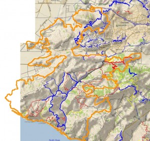
Outline of the Springs Fire burn area (orange), overlaid on a trail and topo map.

Outline of the Springs Fire burn area (orange), overlaid on a trail and topo map.

The park is currently scheduled to reopen on Friday, May 24, with some trails still closed for further repair. The park will be only open during daylight hours until further notice. When the park does open, please protect the wildlife that did survive the fire by not going off the trails.This is a report of what we saw and got accomplished during those two trailwork days.

The first day (8:30 am to 2:00 pm) was spend entirely on Upper Sycamore Trail. We parked at the bottom of the blacktop hill in the large dirt area on the east side of the road, where the outhouse used to be. In it’s place is a piece of a metal frame and a stain of melted plastic in the dirt. Across the road is the remains of an old oak tree that had burned through the base and then toppled over. The tops of the railings on the bridge have been cut off and the surface planks are chared around the edges. The superstructure is steel so it is still strong enough to support fire trucks, but we drove our pickups across one at a time even so.
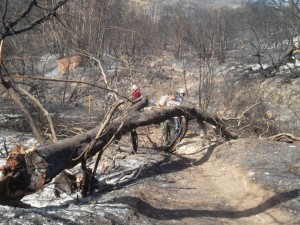
One of many trees fallen over the Upper Sycamore Canyon Trail

One of many trees fallen over the Upper Sycamore Canyon Trail

It was eerie on the trail itself. The fire seems to have burned about 10 feet up from the ground so the leaves are stripped off of the chaparral, but taller oaks and sycamores still have leaves in various states of scorched to dead. Being able to see through the leafless chaparral, we discover that there’s a lot of junk lying on the ground near the trail, including a metal windmill that must have fallen over years ago.The tread of the trail was in good shape. The leaves from the overhead trees that normally carpet it were all gone so we were walking on bare dirt. Unfortunately many of the oaks near the bottom of the trail had burned through the trunk and fallen over. Four or five of them blocked the trail and we spent considerable time cutting them up with a chainsaw and hand saws into pieces small enough for us to drag off the trail.
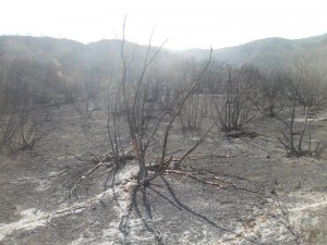
One of the many 'ash ghosts'

One of the many ‘ash ghosts’

There were a lot of ‘ash ghosts’ on the ground: markings left when whole trees or large limbs had fallen and been completely consumed, leaving a pattern of ash where branches used to be.Fortunately not all the oaks fell to the ground, but too many of them did.

The oaks were not the only trees that fell across the trail. Dozens of large chaparral bushes, about 8 feet tall, had collapsed across the trail. Many were burned completely through at the base so we just picked them up and tossed them off the trail, but others were still attached to their roots, so we needed to cut them through with hand saws before we could unblock the trail.
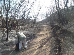
We had to clear a lot of chaparral that had fallen across the trail

We had to clear a lot of chaparral that had fallen across the trail

The amount of fire damage varied a lot from place to place. In some places the grass and most of the chaparral was almost completely gone. Some places weren’t burned at all, but most were singed to some degree. We could see on the hillsides patches where the fire had burned, surrounded by chaparral, and patches of chaparral surrounded by burn. We even saw a few shoots of brand new growth in some heavily burned areas.All of the collapsed oaks blocking the trail were near its lower end. Further up the trail were a few sections with minor rockfalls that we cleared. We also cleaned out three drains in a heavily rutted segment. The top section was relatively unaffected and we were relieved to see the giant oaks at the top of the trail, where it meets Danielson Road, were singed but not seriously damaged.
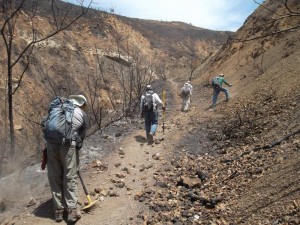
More rockfall to clearOn the second trailwork day, we covered Hidden Pond Trail between the bottom of the blacktop hill and Ranch Center Rd, Sin Nombre and about 2/3 of Blue Canyon Trail. We were able to cover much more ground because there were no fallen oak trees to clear and the two large fallen sycamore boughs shattered into pieces that were small enough to remove without using a chainsaw.

The surrounding land was much the same as Upper Sycamore Trail, except there were large meadows here and they were completely burned. It’s amazing to see how many gopher holes there are — it seems like there are several in each square foot!
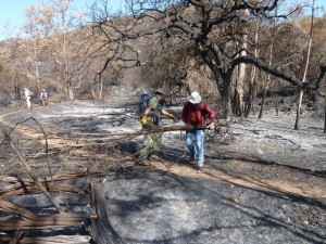
P1220118On both days we saw animals that had survied. We saw lots of ants, some beetles, a few lizards, one snake, a tree squirrel and even a large bobcat resting in the shade of some sycamore trees. Some areas had lots of funnel spider webs even thought the grass was completely burned, but other areas had none. We saw and heard birds, including a couple of small flocks of screeching parrots.

We also came across a group of about a half-dozen mountain bikers on Hidden Pond Trail. They said they heard the trails were open; they claimed they phoned a park agency and were told the trails were open. However, we know they snuck in bacause the main entry points were blocked off and manned by rangers to keep people out. As an open space enthusiast, I was angered more by the fact that they were in the park when it was closed to the public for their safety and to protect the surviving wildlife than by the fact that they were on a trail that is never open to mountain biking. As a mountain biker, I was angered by the fact that these boneheads were putting into jeapardy the goodwill and standing that CORBA has worked hard to establish for the mountain biking community with the various land managers in the Santa Monica Mountains. These were the only unauthorized people we saw in the park over our two workdays there.

Normally I would provide lots of pictures to go along with an article like this one but we have been asked by State Parks not to publish any photos of trailwork or fire damage until after the parks have reopened to the public. They don’t want anyone to see the photos of people working on the trails and assume that the trails are open to everyone.

As a final note, let me remind you, for the sake of the remaining wildlife, to stay on the trails when the park reopens, and I thank you for your cooperation in helping the open space to grow back to it’s former self!

If you would like to help repair the trails, a volunteer workday has been scheduled for Saturday June 8th. For more information and to sign up to help, please visit CORBA’s June 8th trailwork registration page.

Update Friday May 24, 2013. Point Mugu State Park is now completely open, but there is still some debris on some trails, including fallen trees. Use caution on these trails until they are completely cleared of all debris!

View the photo gallery of trailwork on Upper Sycamore Canyon Trail.
View the photo gallery of trailwork on Hidden Pond, Sin Nombre and Blue Canyon Trails.

NPS To Re-Open Additional Trails Tuesday 5-14-13

Monday, May 13th, 2013

THOUSAND OAKS, Calif. – Now that the 24,000-acre Springs Fire is officially controlled, the National Park Service will re-open trails on the western side of the Santa Monica Mountains Tuesday morning, with restrictions.

“We know the public is anxious to return to their neighborhood national park,” said David Szymanski, superintendent of Santa Monica Mountains National Recreation Area. “We’re working as hard as we can to balance that enthusiasm with visitor safety and protection of our resources.”

Rancho Sierra Vista in Newbury Park will partially re-open, but some trails will remain off-limits and the park will close from sunset to sunrise. Due to ongoing safety concerns and trail damage, visitors won’t be able to travel into Sycamore Canyon, but will be able to reach the overlook at the boundary with Point Mugu State Park.

The Sandstone Peak and Mishe Mokwa trailheads will also re-open, as will the Backbone Trail east of the Point Mugu State Park boundary. California State Parks land sustained severe fire damage and all backcountry trails in the area remain closed. (Per an earlier press release, backcountry trails in Pt. Mugu State Park are closed until May 23.) 

Visitors are encouraged to help nature recover from the fire by respecting trail closures and staying on the trail in areas that are open. Foot and bike traffic tramples sensitive soil, vegetation, burrows and nests.

Park officials estimate 70% of Rancho Sierra Vista’s 1170 acres burned during the fire, though the Satwiwa Native American Indian Culture Center and all other structures were protected.

More information is available at 805-370-2301.