Archive for the ‘Trail Access’ Category
Los Angeles County trail access meeting July 20 – mark your calendar!
Thursday, July 8th, 2010Art’s Trail Closure Update
Friday, June 25th, 2010By Mark Langton
Recently I, on behalf of CORBA, sent an email to State Parks District Superintendent Al Pepito regarding an email he sent us. It included a forwarded email from Maintenance Supervisor Dennis Dolinar explaning why they were now closing trails that have for many years been used with knowledge of both the rangers and the maintenance department. (Note: Ranger and maintenance staffs often work independently, and maintenance can and does make decisions without ranger and/or public input.)
Below are the questions I posed and the answers we received from Al Pepito.
CORBA: What is the timetable of the review period Dennis [Dolinar] references in the end of the second paragraph? (From Dennis Dolinar’s email: “It is our intention to keep this area closed to all users until such time as a complete evaluation of the park’s resources can be completed. There will be no attempt to actually remove the trails themselves unless that internal review warrants it.”]
AP: The review process can take anywhere from a year to 18 months.
CORBA: We find it odd that at this point in time CDPR is expending resources for efforts to close prescriptive trails that clearly are not damaging the resources significantly, if at all. Unless there are native resources that are being impacted, there is no clear reasoning behind closing the trails. I understand that it may be a liability concern, but even then, why weren’t these trails closed years ago?
AP: This is a non-system trail not recognized by in our facility inventory. Thus it has never been through the CEQA review process or permitting process. Just because it exists and there is use, does not give the trail status as a recognized facility. It is a resource maintenance issue that needs to be addressed through restoration practices.
CORBA: We are also concerned that your volunteer partners (MBU, CORBA Trail Work Crew) are not being given ample notice in order that they might be able to inform both their own members and the public which they represent.
AP: Without a Trails Supervisor everyone involved are not being communicated with properly. I have asked that the core staff of the district sit down at our next meeting to discuss this issue. The position has been advertised and hope to have one in place by the end of July or sooner.
Obviously Ranger Pepito’s answers raise other questions, such as whether or not they intend to perform a CEQA (California Environmental Quality Act) assessment. And of course, if the review process takes from a year to 18 months, wouldn’t that mean the trails will be reclaimed by whatever plant life exists–assuming no one uses the trails? CORBA will continue its involvement with this situation.
America’s Great Outdoors Initiative
Wednesday, June 23rd, 2010The Obama Administration has announced a second round of Listening Sessions for the America’s Great Outdoors Initiative. These listening sessions will be crucial opportunities for the trail users to bring the Trail issues and the nation’s trail systems into the spotlight as a priority for the Obama Administration.
CORBA volunteers will be in attendance, and we hope that a large mountain biking contingent will attend the Los Angeles meeting on Thursday, July 8, 2010, 3:00 pm to 7:00 pm.
In the event you are unable to participate in person, please submit your comments and stories via the America’s Great Outdoors website at http://www.doi.gov/americasgreatoutdoors/.
Below is the official announcement
NOTICE OF A PUBLIC LISTENING SESSION ON
THE PRESIDENT’S AMERICA’S GREAT OUTDOORS INITIATIVE
Please join senior representatives of the U.S. Environmental Protection Agency, the White House Council on Environmental Quality, the U.S. Department of Agriculture, the U.S. Department of the Interior and the U.S. Department of Defense for a public listening session and discussion in Southern California on conservation, recreation, and reconnecting people to the outdoors. The session will be held July 8 from 3:00 pm to 7:00 p.m. at Occidental College in Los Angeles.
This past April, at the White House Conference on America’s Great Outdoors,President Obama launched the America’s Great Outdoors Initiative to developa 21st century conservation agenda and to reconnect Americans with ourgreat outdoors. The President asked his leadership team to engage the fullrange of interested groups, including State and local governments,community-based organizations, recreation and conservation groups, sportingorganizations, youth groups, and others.
This Los Angeles-based listening session, one of several being held around the country, offers an opportunity to hear and describe the challenges and opportunities we face in land and water conservation, in improving recreational opportunities for a large urban population, and in restoring and conserving our vital natural and cultural resources to enable access to a broad array of outdoor recreation. The July 8th public listening session and discussion is an opportunity for the leaders of the America’s Great Outdoors Initiative to hear from you and other voices in the region about solutions for building a 21st century conservation and recreation agenda and for reconnecting people with the outdoors.
Here are the details:
Listening Session and Discussion Information:
- When: Thursday – July 8, 2010, 3:00 pm to 7:00 pm
- Where: Thorne Hall, Occidental College, 1600 Campus Road, Los Angeles, CA 90041 (See map at http://www.oxy.edu/x6307.xml)
- Who: Senior national and local leaders from US EPA, CEQ, USDA, DOI and DOD will be present to hear your recommendations and to participate in a conversation with you about America’s Great Outdoors.
- Register: This event is free and open to the public. For planning purposes, please register by Thursday, July 1st by sending an email to sun.nelly@epa.gov with your name, the name of the organization with which you are affiliated, if any, your telephone number and email address. We will endeavor to accommodate everyone.
In the event you are unable to participate in person, please submit your comments and stories via the America’s Great Outdoors website at http://www.doi.gov/americasgreatoutdoors/.
If you have questions, please call Nelly Sun at (415) 947-4237. We look forward to your participation – please join us!
Update on the Art’s Trail Closure
Wednesday, June 16th, 2010Last week we reported on the closing of the popular Art’s Trail in Pt Mugu State Park. Since then we have heard second-hand reports of more detailed reasons why the trail and its connectors were closed, namely, that there were archeologically interesting areas in the vicinity, and also sensitive plant species. Here is the response we got from Dennis Dolinar, District Maintenance Chief of the Angeles District of the California State Parks:
Good Morning !
While recently working with several people on an updated official park map for Point Mugu SP, I became aware of a set of unauthorized trails that had been developed by unknown individuals in the section of the park that roughly runs parallel to the Ranch Center Road and between the Sage and Sin Nombre Trails. These illegal routes, which likely started out as simple game trails only used by wildlife, pass through sections of the park that have never been thoroughly reviewed by our resource staff with regard to possible impacts to both natural and cultural resources. Also, the trails themselves have never been evaluated by staff regarding safe and appropriate routing through the varied terrain they cross. Subsequent conversations with our staff brought to light that there is at least one recorded culturally sensitive site in the immediate area and the entire meadows area should be further investigated . There also are as yet unconfirmed reports of unusual seasonal plant life in the area.
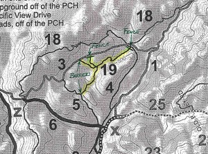 The opportunity to close these unauthorized routes presented itself last month and, as the District’s Chief of Maintenance, I worked with a local boy scout troop to block-off the four obvious access points to the area in question. It is our intention to keep this area closed to all users until such time as a complete evaluation of the park’s resources can be completed. There will be no attempt to actually remove the trails themselves unless that internal review warrants it. Ultimately, these routes of travel could possibly re-open but that has yet to be determined.
Just to make sure that we are talking about the same set of unauthorized trails, I’m attaching a copy of a portion of a private party trail map that I’ve taken off the Internet. The person that produced that map identifies these routes as being Art’s Trail ( #19 ). I have also heard these same routes called by other names by park visitors.
Any support that the CORBA membership can give us to manage this situation would be greatly appreciated as we strive to protect the park, it’s resources and all our visitors.
I hope this helps you better understand the situation. Please share this information with others in your group. ===> Dennis D
Despite the above email, questions still remain surrounding this issue and CORBA will continue to pursue any and all information pertaining to this closure.
For more, see the June 25th update on this issue.
Sullivan Canyon Closure Update
Tuesday, June 8th, 2010From Sharon O’Rourke of The Gas Company
As of Friday, June 4th, we completed the initial access road repair work. Access from Mulholland was re-opened to the public as of Saturday, June 5th.
On Wednesday, June 23rd, we will start the pipeline protection work which will include the final planned access road repairs and covering the remaining pipeline exposure areas with the concrete mats. This will require closing public access to Sullivan Canyon at both Mulholland and Queensferry Road. The closure is necessary for public safety due to the equipment needed for the placement of the mats. The work is estimated to take 3-4 months.
Update August 31: Apparently the canyon will be closed until November 12th.
More Unauthorized Trails “Closed”
Thursday, June 3rd, 2010By Mark Langton
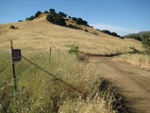
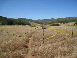 More trails, this time in Point Mugu State Park, have been deemed unauthorized and marked with signs and fencing designating them as closed (View our earlier article on Malibu Creek State Park). One trail, known as “Art’s Trail,” connects Sage Trail and Sin Nombre, paralleling the paved road that leads to Wood Canyon. Two other shorter trails connect to the paved road farther to the west. Here is the narrative and explanation given for these actions from Dennis Dolinar, District Maintenance Chief, Angeles District, California State Parks:
Last weekend, I participated in a project with a group of local boy scouts from Newbury Park to erect a combination of both fences and barriers on the four entry points to a set of unauthorized trails that lie in the backcountry of Point Mugu SP. I had become aware of these specific trails a couple of months ago while working with others on a new official trail map for the park. After discussions with our both our Senior Environmental Scientist, Suzanne Goode, and our District Archeologist, Barbara Tejada, I decided to take the steps necessary to close this set of trails until such time as they can be fully evaluated in terms of both user safety and possible resource damage.
The trails in question are totally unofficial and, as such, they probably go by various names in the hiking, biking and equestrian communities. A private website known as Ventura County Trails uses the following names to describe the trails in question. The main segment that travels roughly parallel to Ranch Center Road from Sin Nombre Trail to Sage Trail is been labeled by them as being “Art’s Trail”. In addition, there’s two short connector trails that go up to the paved road that have been given the names “Kubler” and “Clark”. It appears quite possible to me that these routes started out as little more than game trails that skirted the large, fragile meadow but, with repeated use by those park visitors who somehow knew that they existed ( they do not appear on any official state park maps ), they have become more obvious over time. Attached you will find a location map of the closed trails.
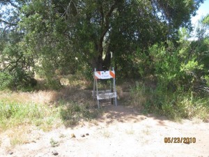 At this point in time, the trail entrances have been closed by use of simple barriers and fences but there are no immediate plans to destroy the trails themselves. The hope is that we can stop and/or minimize the use of this set of trails until such time as staff can evaluate the park resources that are potentially effected by these types of visitor use. Many of the people I spoke with out on the trail last weekend were disappointed but seemed to understand the need for us to manage this issue.
As time and work priorities allow, I will get back to you and your organization again as to our progress on this ongoing project.
While the above explanation is not wholly acceptable, it is within their purview to undertake these actions. What is most frustrating about the above comments is that State Parks is expending resources on projects that lack more comprehensive internal, peer, and constituent review and input. CORBA is monitoring this situation closely and will have more information as we obtain it.
(photos courtesy Dennis Dolinar)
Also, see the June 16th update on this story.
Malibu Creek State Park Trail and Plant Rehab
Friday, May 21st, 2010By Mark Langton
The Grasslands Trail in Malibu Creek State Park between Mulholland Highway and Crags Road Trail has undergone grading and widening to allow ranger and emergency vehicle access. Also, the renegade trails that lead down to Crags Road from Grasslands Trail have been posted as “area closed due to plant rehabilitation.” Comments from Ranger Lindsey Templeton of California Department of Parks and Recreation (CDPR) state the the trails will be closed. Comments from CDPR engineers noted that a new properly built connector will be installed once the rehabilitation is complete. Please do not use trails that are marked as closed for rehabilitation. In the case of the Grasslands Trail, there is no significant advantage to using the trails that are being closed for rehab.
A push to preserve the San Gabriels
Sunday, May 16th, 2010Reeves, 69, who first fished this stretch of the San Gabriel River’s west fork with his father more than half a century ago, was in his element — scanning the eddies for rising wild trout in a wilderness that resurrected childhood memories.
“I’d be happy if this place stayed just the way it is,” the stout conservationist said. “But with 10 million people living within an hour’s drive, these mountains definitely need more protection.”
Reeves is a member of San Gabriel Mountains Forever, a campaign that is pushing Rep. David Dreier (R-San Dimas) to fashion a bill that would shield a larger portion of the 655,000-acre range and its free-flowing rivers from pollution and population woes with the strongest federal protections available.
The goal is to add 30,000 acres to three existing wilderness areas and have 44 miles of San Antonio Creek, the middle fork of Lytle Creek and portions of the San Gabriel River’s east, west and north forks protected under the national Wild and Scenic Rivers Act, which would prohibit new damming.
Today, only a 7-mile stretch of Piru Creek, in the northern San Gabriel Mountains, is designated as wild and scenic.
Conservationists fear that time is running out. Encroachment from foothill subdivisions in the San Gabriel Valley and Lancaster, cuts to the U.S. Forest Service budget, arson fires and millions of annual visitors are eroding the qualities that make the mountains special, they say.
“Our aim with this proposal is to protect the one-third of the Angeles National Forest that is still unspoiled open space,” said John Monsen, regional representative of the Sierra Club, one of several environmental groups in the campaign, including the Wilderness Society and Friends of the River. “The trick is to get it introduced in time for this Congress to vote on it. If it is delayed another year, there is no telling what will happen.”
![53758225[1] Down the mountain (Brian van der Brug / Los Angeles Times)](http://corbamtb.com/news/wp-content/uploads/2010/06/537582251-300x196.jpg)
Hikers follow a trail near the middle fork of Lytle Creek in the Cucamonga Wilderness. "Our aim with this proposal is to protect the one-third of the Angeles National Forest that is still unspoiled open space," said John Monsen, regional representative of the Sierra Club. "The trick is to get it introduced in time for this Congress to vote on it. If it is delayed another year, there is no telling what will happen."
As part of an effort to avoid conflict, San Gabriel Mountains Forever has altered proposed wilderness boundary lines to accommodate utility company and water district easements, and has added specific language to its proposal to ensure that the Los Angeles County Fire Department has access to wilderness areas in the event of an emergency.
Dreier was unavailable for comment. But his legislative director, Alisa Do, said, “the congressman is committed to seeing it through.”
“But we have to be careful and cautious because this area is prone to wildfires and flooding,” she said. “Any change we make would be permanent, so the congressman continues to do his due diligence to ensure this process is done correctly.”
So far, nine cities, including Claremont and La Canada-Flintridge, have filed letters and passed resolutions in support of the proposal, which is also backed by dozens of San Gabriel Valley churches.
Negotiations continue, however, with the Los Angeles County Department of Public Works, which is worried about potential impacts on its ability to operate crucial flood control and reservoir systems.
Of particular concern is Cogswell Dam, a remote county flood control operation that looms over an 8-mile-long stretch of the San Gabriel River’s west fork proposed for wild and scenic status.
The operation controls the flow in the stream, which provides some of the best fly fishing in Southern California and helps recharge the metropolitan aquifer in the flatlands below. It also has an easement for the 8-mile-long asphalt lane connecting the dam to Highway 39.
“We support the conservation effort being proposed by San Gabriel Mountains Forever,” said Mark Pestrella, the county deputy director of public works. “But they have to recognize that we run a very large system that includes man-made dams up there that provide water and safety for millions of people. We want to make sure that we are not giving away rights to some critical future need.”
Stretching in an oblong mass from Santa Clarita to San Bernardino, the mountains’ wrinkled slopes and lush canyons are also defined by the habitat and wanderings of many rare and endangered species, including Nelson’s bighorn sheep, mountain yellow-legged frogs, Santa Ana suckers and Pacific pond turtles.
Yet, on a recent weekday, picnic sites and trail heads along Highway 39 north of Azusa were strewn with trash, broken glass and discarded lawn chairs and ice chests. Interpretive signs and boulders as big as billboards were covered with graffiti. Picnickers fished and waded in a stream that has turned the color of coffee because of sediment and ash from the Station Fire, the devastating arson blaze of last year.
Marty Dumpis, deputy forest supervisor for the U.S. Forest Service, which manages the range, believes the proposal would focus additional attention on the San Gabriels and their need for “more resources and educational programs.”
As it stands, the financially strapped Forest Service relies on volunteers to help pick up trash, remove graffiti, patrol picnic areas and run conservation and educational programs. Among them are D.D. Trent, a geologist, and Ronald Quinn, a professor of biological sciences at Cal Poly Pomona.
On a recent weekday, Trent and Quinn led a hike along the middle fork of Lytle Creek, a network of cascading snowmelt, ponds and wetlands rolling out of a rugged canyon thick with sycamores, alders, oak and Douglas fir trees.
As a botanist, Quinn marveled at the living bluish-green blanket of shrubs collectively known as chaparral — holly-leafed cherry, Indian paintbrush, white sage, chemise, wild onions, manzanita — covering the mountains’ shoulders.
As a geologist, Trent admired the “restless, adolescent peaks being squeezed upward by a giant vice of tectonic strain. If not for the intensity of the erosion, these would be the tallest mountains in the world.”
But as occasional weekend hikers in the canyon, they were confounded that a great majority of the people who live only a few minutes away never glimpse its backcountry trails.
Verdugos: City Requests Illegal Features be Removed
Sunday, May 9th, 2010At a recent meeting of the Burbank Trails Committee, City Officials notified us that illegal features that have been built along Preston Ridge in the Verdugo Mountains must be removed.
The features have appeared over the past year or two. Near the top of the Vital Link trail (a hiker-only trail), there is a small wooden feature. Beyond that, there are some small tabletop jumps and bermed turns. The City is giving the builders until the end of May to remove the features and the materials used before they go in and take them out.
“Preston Ridge is not an official trail” according to the City representative. However, the trail was created by hikers hiking across firebreaks along the ridge line more than two decades ago. One Committee member has hiked there “his whole life.” The City is in a dilemma as to what to do with the “trail” itself, as it has such a long use history, but has never been through any process to become an official trail. The City Attorney has determined that the features themselves are a liability.
The work on the ridge is that of many different people and groups. The City has been in contact with some of the builders, but they are only responsible for a small portion of what has been constructed. Many of the recently altered sections of the trail were not done “up to safe, sustainable standards” and did not follow the original line of the existing unofficial but long-used trails along the ridge.
Meanwhile, CORBA has submitted a draft proposal to construct a new section of trail with mountain-bike specific features. The City Attorney and others are going over the proposal in detail, but have not yet accepted or denied the proposal. They have expressed hope that it can eventually be accepted and completed. The City needs more time to study the proposal and has requested information and examples of how other cities around the country have dealt with new mountain-bike enhanced trails.
Currently most single track trails in Burbank open space are closed to bicycles. There has not been a new official trail constructed since 1998 when the Vital Link trail was completed.
Setback in Montana
Monday, April 12th, 2010According to a story in the Billings Gazzette, as of May 1st it will be illegal to ride 150 miles (0ut of 170) of trail in Montana’s Hyalite-Porcupine-Buffalo Horn Wilderness Study Area, which includes the Gallatin Crest Trail. A judge has declared that mountain biking ruins the opportunity for solitude for others, and has interpreted that as grounds to restrict mountain bike access to this Wilderness Study Area.
Read more on Dirt Rag‘s blog and the Billings Gazzette story.
If you’re ever wondering why it is important to support mountain biking advocacy, consider the challenges Montana mountain bikers are currently facing. This legal decision could be precedent-setting, resulting in trail closures around the country in areas deemed “eligible” for wilderness designation, even though they have not yet been designated wilderness.


![53771026[1]](http://corbamtb.com/news/wp-content/uploads/2010/06/537710261-300x260.gif)

