Archive for the ‘Trail Access’ Category

State Parks Upgrading Tapia Spur Trail

Wednesday, February 15th, 2012
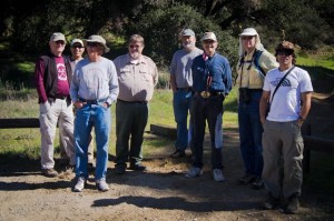
Stakeholders from several groups inspect the upgrades

Stakeholders from several groups inspect the upgrades

On February 14, 2012, CORBA board member Steve Messer met with State Parks officials and representatives from hiking, conservation and equestrian groups. Together they walked the Tapia Spur trail which was slated for upgrades meet multiple use standards last year. The trail remains open to the public, though the work is well underway.

Originally constructed in the mid nineties, since being opened to multiple use there have been some reports of user conflicts, mostly due to excessive speed of bicycles. This was exacerbated by poor sight lines with blind corners and switchbacks.  One of the significant trail upgrades is a reroute that will eliminate four switchbacks. The new section is still being machine cut, and like the rest of the trail, will be extensively hand-finished.

The entire trail is being re-cut to a 5′ width with a Sweco. Visibility is being improved on many sections by cutting back brush and, where appropriate, cutting back the backslope. The entire trail is being outsloped for improved drainage and to reduce long term maintenance needs.

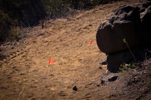
The most significant change is the inclusion of approximately 17 “pinch points.”  These consist of large 500 pound-plus rocks at least 18″ high strategically placed on the uphill side of blind corners. They will be embedded into the tread and placed about 36″ apart, in such a manner as to require a bicycle to weave between them. This will slow down cyclists at the spots with the most potential for startling of other trail users. These features are a key component of IMBA’s recommended speed control measures. They can add challenge and fun to a trail for cyclists, while allowing horses, hikers and personal mobility devices to pass easily. But most importantly, they improve the overall safety of the trail.

Flags show approximate locations of pinch point rocks

Flags show approximate locations of pinch point rocks

Another feature being added at key locations on the trail are rock-armored swales. The rock armoring leaves a rough tread while also protecting the natural drain from erosion by water or trail users. The rough tread is also expected to slow cyclists and add interest and challenge to the trail. Rocks were being imported from Malibu Canyon to create the pinch points, and harvested locally for the rock-armoring and rip-rap. The heavy rocks were being brought up the trail on mechanized carriers.

According to Knapp, “these features will slow cyclists and reduce the potential for them startling other trail users. We hope that good trail etiquette will then kick in and reduce conflict. However,” he continued, “we can’t control attitude or behavior.”  We concur, and will continue encouraging proper etiquette through our outreach and education efforts, including our free Mountain Bike Skills Clinics.

Knapp also commented on the mission of the State Park to protect the natural resource. “Trails are there for people to enjoy the resource,” he said, “not for thrillseeking.”  He talked about the fact that they must adapt to the changing trail user demographic, while keeping within their mission. These multi-use standards and the objective Change In Use process are a part of that adaptation to accommodate the growing number of off-road cyclists.

Everyone present seemed pleased with the trail improvements. “I like what I see,” remarked one of the Santa Monica Mountains Trails Council representatives “we’ll just need to give it a chance.”
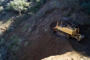
Tapia Spur Re-Route being cut

Tapia Spur Re-Route being cut

The trail improvements are not inexpensive, and funds are being funneled to this project from Sacramento. The State’s new Change In Use procedures will hinge upon their ability to implement these design standards on trails that are candidates for a change to multi-use, but currently closed to bikes. CORBA has a long-standing list of requests for trail Change In Use in the Santa Monica Mountains. While Tapia Spur was already designated multi-use, the upgrades will hopefully allay the concerns of the trail community at large about the pending changes to Lookout and Yearling trails. These two trails have been recommended for a change in use, and could be the next to receive such a treatment.

The trail will be showcased at the upcoming Parks Conference and the Trails and Greenways Conference. The work is expected to be completed by the first week of April. L.A. County is considering implementing a similar trail review process for County trails in the Fifth District. Overall, we believe improvements will not negatively impact the user experience for cyclists, and by reducing conflicts, they will in fact enhance the experience for all users.


(more…)

Proposed State Park Closures Threaten Bicycle Access

Tuesday, January 31st, 2012

Via the California Bicycle Coalition

This summer the state could begin closing 70 state parks, many of them popular for bike touring, bike camping and mountain biking. That’s why there’s a campaign to help keep them open.

Locally, the Santa Susanna State Historic Park is slated for closure.  This park is South of the 118 freeway, between Chatsworth and Rocky Peak. It includes some multi-use trails, including the old Santa Susanna Stagecoach road and El Camino Nuevo.

Statewide, there’s a lot at stake for bicyclists. Eighteen parks could be closed along the Pacific Coast Bike Route, an international bike touring destination and California’s only state-designated bike route, including two in Mendocino County that are crucial stops for bike tourists. Five parks popular for mountain biking, including Annadel, Brannan Island, China Camp, Henry Coe and Sugarloaf, are also on the closure list. Nineteen of the 58 state parks that offer low-cost “hike or bike” campsites for those arriving by bike or on foot are set to be closed.

Tell your legislators and Gov. Jerry Brown there are better solutions to the state’s budget crisis than closing state parks. Make the case in person at the 10th annual Park Advocacy Day on March 20 in Sacramento. If you own a business that would suffer due to the proposed state park closures, join the California State Parks Foundation’s “Closing Parks is Bad for Business” campaign.

New U.S. Forest Service Planning Rules Presents Opportunities for Mountain Bike Groups

Friday, January 27th, 2012

Via IMBA

For Immediate Release 1-27-2012

Contact: Mark Eller
IMBA Communications Director
markeller@imba.com
303-545-9011

The U.S Forest Service recently announced a new set of rules that will shape the way foresters oversee its lands, including planning for and implementing trails and other recreational facilities. The Department of Agriculture, which oversees the Forest Service, posted the new procedures online today.

“This is welcome news for IMBA and its affiliated chapters and clubs,” said Mike Van Abel, the executive director for the world’s largest association of mountain bike organizations. “IMBA’s outstanding relationship with the Forest Service sets the stage for our local affiliates to partner with individual forest units as they make plans for shared-use trails.”

IMBA sent dozens of representatives to the Forest Service’s national series of listening sessions as it was preparing for the just-announced rule change. “Those efforts proved to be really worthwhile,” says Jeremy Fancher, IMBA’s lead attorney. “It’s particularly encouraging to see a renewed emphasis on following best practices and considering scientific evidence. IMBA’s partnership agreement with the Forest Service will help us provide the right information for effective recreation planning.”

Fancher frequently advises IMBA-affiliated chapters and clubs on forest planning efforts. IMBA also offers scientific studies on the impacts of mountain biking and guidance on trail design on its website. Learn more about planning efforts in the forests near you by visiting the Forest Service’s Schedule of Proposed Actions (SOPA) website.

To raise public awareness about how mountain bikers and Forest Service staff interact, IMBA helped sponsor Pedal-Driven, an award-winning documentary. The Forest Service has officially endorsed the hour-long film, and IMBA’s local chapters and clubs are currently hosting dozens of screenings. “This production documents the great things we can accomplish when we work together to solve problems,” said Okanogan-Wenatchee National Forest Supervisor Becki Heath, whose forest is featured prominently in the documentary.

New San Vicente Mountain Communications Tower Public Presentation (the Nike Site)

Thursday, January 12th, 2012
A new communications tower is being proposed for the top of San Vicente Mountain, near the location of the Nike site at Westridge and Mulholland in the Santa Monica Mountains. This is a highly popular destination for trail users and visitors to the Santa Monica Mountains.

UltraSystems, a company specializing in environmental planning, will be conducting a public  presentation on the project for interested parties:

7:00 p.m., Tuesday, January 17, 2012, West Los Angeles City Council Office, 1645 Corinth Ave., Second Floor Hearing Room, LA, CA 90025.  

The presentation will help the public and the trail user communities understand exactly what the impacts of this new 200′ tower will be.

While this meeting will concentrate solely on the the San Vicente Mountain project, at least four other sites are being proposed for similar projects.  Mount Lee is within Griffith Park, behind the Hollywood sign and is off-limits to cyclists.

The other peaks are Mount Lukens in the Angeles National Forest, Verdugo Peak at the top of  Hostetter Fire Road (AKA “La Tuna”), and the Baldwin Hills.  The Mount Lee and Baldwin hills projects are for new equipment buildings within existing facility boundaries. Mount Lukens and Verdugo Peak are both slated to have existing towers replaced and upgraded. These projects will be discussed at a later meeting.

Santa Clarita Trails Public Hearing Announced

Wednesday, January 11th, 2012

From the Santa Clarita Valley Trail Users:

Dear Friends,

Our fight to re-open The Canyon Trail and Vasquez Rocks to mountain biking continues.

As a part of the “trail assessment process” the County is undertaking, a “first” public hearing will be held on this matter on Wednesday, February 15 at 7PM at William S. Hart Park in the “Hart Hall” building.  This is a very important meeting and we need all hands on deck.  So please mark your calendar and plan on bringing your spouse and kids and maybe a few “Share the Trails” signs.  More information will follow as we plan for this meeting.

Additionally, next week, some of our committee members will be meeting with Russ Guiney to discuss the status of our request to re-open these trails and to express our concerns about the process and approach they are undertaking to address this issue.  Mr. Guiney is the Director of LA County Parks and Rec and the buck does stop with him.  Ultimately, this is his decision.  Wish us well.

Thank you for your support and letters to Supervisor Antonovich.  We would not have made it this far without it.

See you on the trials!

Please sign our petition:  http://www.ipetitions.com/petition/canyon_trail_mtb_access/
Join our Facebook Group:  http://www.facebook.com/groups/saveplaceritatrail/


SCV Trail Users
Safe and Equal Access for All Trail Users
SCVTrailUsers@gmail.com
To add your name to our email list, please email SCVTrailUsers@gmail.com with such a request.

Notice of EIR for Topanga State Park General Plan

Friday, December 9th, 2011

NOTICE OF AVAILABILITY AND INTENT TO ADOPT
AN ENVIRONMENTAL IMPACT REPORT FOR THE PROPOSED
TOPANGA STATE PARK GENERAL PLAN

Date: December 5, 2011

The California Department of Parks and Recreation (CDPR) has directed the preparation of and intends to adopt an Environmental Impact Report (EIR) for the proposed project, in compliance with the California Environmental Quality Act (CEQA) and State CEQA Guidelines. CDPR is the lead agency for the proposed project under CEQA.

PROJECT LOCATION: Topanga State Park is a CDPR park unit located within Los Angeles County.

DESCRIPTION OF THE PROPOSED PROJECT: The General Plan directs the long-range management, development and operation of Topanga State Park by providing broad policy and program guidance including goals, guidelines and objectives for the management of the Park. The plan will set aside a number of management zones including; a I/Ihldlands Zone constituting over 70% of the Park’s acreage that shall contain minimal development with modest camping opportunities; a Cultural Presen/e to heighten the interpretation and protection of outstanding cultural resources; a Historic Zone whose core includes the former Rancho Las Lomas Celestiales (now known as Trippet Ranch); as well as other zones for resource management, visitor use and accessible interpretive and recreational programs. The Plan also contains specific proposals to consolidate the Park’s trail system through eliminating duplicate trails and relocating trails away from sensitive resources.

PUBLIC REVIEW PERIOD: The Draft EIR is being circulated for public review and comment for a period of 45 days, beginning Thursday December 8, 2011 and ending on Monday January 23, 2012. Your views, comments and questions regarding this Plan are welcomed. They should be directed to:

Luke Serna, Park & Recreation Specialist
8885 Rio San Diego Dr., Suite 270
San Diego, CA 92108

or by email at

enviro@parks.ca.gov

Copies of the EIR may be reviewed at the following locations during normal business hours or downloaded from the CDPR website at the following web address:

http://www.parks.ca.gov/?page_id=25956

California State Parks, Angeles District Office, 1925 La Virgenes Road, Calabasas, CA 91302

Help Preserve Trails and Parks Funding in 60 Seconds

Monday, November 28th, 2011

Open space. City parks. Thousands of miles of singletrack across all 50 states. If you value those things, you will take just 60 seconds to help IMBA support the Land and Water Conservation Fund (LWCF). All you have to do is sign a petition.

The petition asks the Obama Administration to fully and permanently fund the LWCF and its work buying open space and helping cities and counties build parks, many of which contain mountain bike trails and are in your own backyard.

TAKE ACTION! If we reach 25,000 individual signers by Dec. 16, the Obama Administration will look at the issue and give an official response. Please sign today!

LWCF funds are being diverted from their intended use. Of the $900 million authorized this year, very little of that is actually going toward America’s parks and outdoor recreation areas. Be part of a united voice. Help us urge the White House to restore full, dedicated and permanent funding for the LWCF.

It only takes a minute. Sign the petition today!

San Gabriel Watershed and Mountains Special Resource Study – Revised Draft Released

Friday, October 28th, 2011

The National Park Service is conducting a “special resource study” of portions of the San Gabriel River watershed and the San Gabriel Mountains. CORBA attended the previous round of public input sessions and reported on the process in 2009.  In the original study proposal there were three alternatives presented, A, B, and C.  We supported and recommended a combination of the areas proposed in Alternative A and the management strategies proposed in Alternative C.

In the recently released executive summary, the NPS reports that it has made the following determinations about the study area:

  • Natural and cultural resources of the San Gabriel Mountains and Puente-Chino Hills are nationally significant, in that they meet all four of the NPS criteria for national significance.
  • The study area is suitable for inclusion in the national park system because it represents natural and cultural resource types that are not already adequately represented in the national park system or protected by another land managing entity.
  • The NPS determined that a collaborative partnership based park unit which respects the complex mix of land use, ownership, and regulatory authority in the study area would be a feasible addition to the national park system. A large traditional national park unit, owned and operated solely by the National Park Service, is not feasible.
  • Need for NPS Management: NPS management in partnership with existing agencies and organizations is the best option for enhancing protection of significant resources, for improving access to recreational opportunities in the region, and for providing coordinated interpretation and education about significant resources.

Backbone Trail Just Got Closer to Completion

Thursday, September 22nd, 2011

Photo: National Park Service

The National Park Service has completed the purchase of another important land parcel along the route of the Backbone Trail, leaving just a scant mile or so still not open to the public. For more information, click here.

COSCA Strategic Plan Public Workshop Sep 20

Tuesday, September 13th, 2011

The Conejo Open Space Conservation Agency will host a public workshop to solicit your comments as a basis for developing a strategic plan for the open space and trail system of the Conejo Valley. The public is invited to provide their opinions and thoughts about the mission of COSCA, as well as their vision of how the open space and trail system should develop in the future. Click here to visit COSCA’s website.

DATE: Tuesday, September 20 from 7:00 PM – 9:00 PM

WHERE: Conejo Recreation and Park District Headquarters, Board Room 403 West Hillcrest Drive, Thousand Oaks, CA 91360

CONTACT: Shelly Austin, COSCA Associate Planner, saustin@toaks.org or (805) 449-2339.