Posts Tagged ‘Station Fire’

FHA Plans for Mueller Tunnel, Mt. Lowe Fire Road

Monday, January 24th, 2011

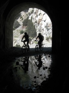
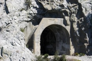
Mueller Tunnel 2006, Mount Lowe fire roadThe Mueller Tunnel has long been a right-of-passage for many mountain bikers riding the outstanding front country trails of the Angeles National Forest.  It is near Eaton Saddle along the Mount Lowe Truck Trail. The tunnel was closed after a landslide almost sealed the western end of the tunnel in 2009. The area has experienced many rock slides over the years. The steep, rocky terrain above the tunnel and fire road remain unstable and unsafe.

There has also been significant damage to the retaining walls which support the fire road next to the tunnel. Several years of heavy rain, and the subsequent Station Fire have kept the area closed for some time. In its current condition, the Mount Lowe Fire Road would remain closed even if the Station Fire closure order was removed.

Mt. Lowe Fire Road provides mountain bikers and hikers access to the Mt. Lowe trail, Sam Merrill Trail, Idlehour trail, and was a popular shuttle option from Mt. Wilson road. It was originally constructed in 1942. It also provides volunteer trail crews like CORBA’s convenient access to those trails for trailwork.

The Federal Highway Administration and the Angeles National Forest are proposing to reconstruct a portion of the roadway adjacent to the tunnel, to restore through access for Forest Service and fire fighting vehicles as well as for hiking, mountain biking and equestrian use. The construction would involve a new retaining wall to tie in to what remains of the existing retaining wall. The objective is to restore the fire road to existing roadway widths and stabilize the road.

Mueller Tunner riders, 2006, Mt. Lowe fire roadThe Federal Highway Administration is requesting public feedback on the project.  Feedback should be sent in by March 4, 2011 to Mr. Micah Leadford (HFPM-16), Federal Highway Administration, 12300 West Dakota Avenue, Suite 380, Lakewood, CO 80228 or by email to micah.leadford@dot.gov; by telephone at 720-963-3498.

CORBA will be submitting our feedback in the comings weeks.

Revised Station Fire Closure Order Issued

Saturday, January 22nd, 2011

The forest service has just issued a revised closure order, going into effect tomorrow, January 22, 2011.

The only changes are the opening of the Red Box picnic area and Millard Campground. Though forest visitors will be able to stop, park and picnic at Red Box, all the surrounding trails remain closed. This order is in effect through January 21, 2012. The official notice and a map are available from the Forest Service web site.

According to the Forest Service, the area is still unstable and subject to slides, especially after events like the December storms. Canyons are also subject to flash flooding. Volunteer groups including CORBA have not been allowed to do any additional trailwork in the burn areas since the first rains of the winter season. However, much of the area is showing good signs of recovery.

Highway 2 remains closed between La Canada and Clear Creek, though it is now possible to drive to Red Box and Clear Creek from Upper Big Tujunga Canyon road.  Caltrans has not announced an expected opening date.

Mountain Bikers Preserving the Trails

Monday, November 8th, 2010

Sunday’s trailwork on El Prieto went exceptionally well. We had perfectly cool, clear weather, damp soil that was easy to work with, and good spirits all around. Thanks to the approximately 50 people who came out to show this heavily damaged trail some much-needed love.

Rock Armoring Teamwork

Rock Armoring Teamwork

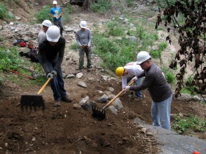
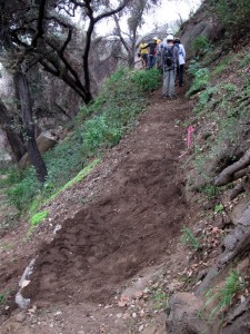
In over 320 person-hours of labor, several washed out drainages were restored, brush was cut back, and many vulnerable sections of the trail tread received rock-armoring treatment. We were even able to restore one section of the original trail that had all-but vanished since the fires. With some diligent hand-tool work and brush cutting, the “cactus corner” section was re-cut and benched, and is ready for finish work.

Special thanks to the St. Francis high school mountain bike team, who came out in force to contribute. Of today’s volunteer trailworkers, more than half were high school team mountain bikers.

As high school students, not only did they learn about trail construction and sustainability, they also gained insight into what makes a “good” trail: how it flows, how it handles water, how sight-lines affect safety on the trail and many other tidbits that one usually doesn’t have time to think about when riding a trail.

Another wonderful aspect of high-school team riders is that many of their parents also get involved. Many are introduced not only to the sport of mountain biking, but to volunteerism and trail stewardship. At least eight parents of high school racers also put sweat equity into the trail on Sunday.

The Forest Service is also requiring all volunteer trail working groups to use safety gear including gloves and hard hats. Thanks to the generous support of REI we were able to outfit all our volunteers with hard hats, a first for CORBA trail crews. We also thank Flat Attack tire sealant for their support of CORBA’s programs.

Special thanks also to Banner Moffat and the Friends of El Prieto, for their ongoing regular work that has helped keep this trail from disappearing altogether since the Station Fire, even though it remains closed to the public. We’re hoping that El Prieto will be a top priority for re-opening by the FS after the rain season ends.

El Prieto trailwork

The original trail restored

Flash flooding and unstable hillsides are still major concerns, and the reason this and many other Station Fire trails will remain closed at least through next spring. In a recent meeting with the non-motorized trails supervisor for the forest, we discussed some creative ways that CORBA, the Friends of El Prieto and other volunteers might work together to open this trail sooner, rather than later. Some possibilities might include a “conditional” opening, where the trail would be closed at any sign of rain, and surveyed after each rain for safety. At this point, the mountain bike community would welcome any access to El Prieto.

Keeping the trail in good shape is the first and most important step towards that goal. Thanks again to everyone who came out!

Station Fire Closure Order Extended

Saturday, September 25th, 2010

Last week the Forest Service issued an updated closure order for the Station Fire burn areas of the Angeles National Forest. The closure order has been extended until 9/19/2011. Part of the Forest has been opened. Unfortunately, the newly re-opened section of the forest is limited to a small portion in the Sunland area. This is much less than most had hoped for, but includes areas around the Doc Larsen trail which CORBA trail crews worked on back in June and July.

Here is the official press release from the Forest Service:

Date: Sept. 17, 2010
ANF Release # 10-12

FOR IMMEDIATE RELEASE

Angeles National Forest
701 N. Santa Anita Avenue
Arcadia, CA 91006

www.fs.fed.us/r5/angeles

Contact: Sherry Rollman or
John D. Wagner at (626) 574-5208

Angeles National Forest reopens areas offering hiking, picnicking

ARCADIA, Calif.–Angeles National Forest will reopen an area about five miles long and two miles wide, northwest of Sunland, closed since the Station Fire last year.

The reopening of the Little Tujunga-Riverwood area is set for Monday (Sept. 20) and will offer the public recreation including picnicking and hiking. The area is being opened after trail improvements and storm-debris removal were completed.

The bulk of the forest’s burned areas remain closed for public safety, until further notice. “The Forest Service intent is to reopen areas severely damaged in the fire over the next few years as conditions allow,” said Jody Noiron, forest supervisor.

“We are developing a cohesive plan to create healthier, more sustainable ecosystems, involving water, vegetation and wildlife,” Noiron said. “We are making the hard decisions toward a healthier open-space for the L.A. basin in the future.”

Reopenings are taking place through a restoration plan, which engages the public on improving the health of the San Gabriel Mountains, and enlists volunteers.

The Forest Service invites volunteers, partners and others to help the forest with its natural resource conservation needs. If individuals or groups are interested in joining the efforts please visit our website at http://www.fs.fed.us/r5/angeles/.

The forest order for the pending reopening and an official map can also be viewed on the website.

Order No. 01-10-05
AREA CLOSURE
ANGELES NATIONAL FOREST
Pursuant to 16 USC 551 and 36 CFR 261.50(a) and (b), and to protect natural resources and provide for public
safety, the following acts are prohibited within the Station Fire Recovery Area of the Angeles National Forest. This
Order is effective from September 20, 2010, through September 19, 2011.
1. Going into or being upon National Forest System lands within the Station Fire Recovery Area, except
the Hidden Springs Day Use Area and Monte Cristo Campground. The Station Fire Recovery Area is
described in Exhibit A and shown on Exhibit B. 36 CFR 261.53(e).
2. Being on any National Forest System road within the Station Fire Recovery Area, which is described in
Exhibit A and shown on Exhibit B. 36 CFR 261.54(e).
3. Being on any National Forest System trail within the Station Fire Recovery Area, which is described in
Exhibit A and shown on Exhibit B. 36 CFR 261.55(a).
Pursuant to 36 CFR 261.50(e), the following persons are exempt from this Order:
1. Persons with a permit from the Forest Service specifically authorizing the otherwise prohibited act or
omission.
2. Owners or lessees of private land within the Station Fire Recovery Area are exempt from the prohibitions
listed above to the extent necessary to gain access to their land.
3. Persons who reside on private land within the Station Fire Recovery Area are exempt from the prohibitions
listed above to the extent necessary to gain access to their residences.
4. Persons with a special use permit or contract from the Forest Service authorizing work within the Station
Fire Recovery Area and their employees, sub-contractors, or agents are exempt from the prohibitions listed
above to the extent authorized by the special use permit or contract.
5. Any Federal, State, or local officer, or member of an organized rescue or fire fighting force in the
performance of an official duty.
Angeles National Forest Recovery Plans

Tuesday, June 1st, 2010

There was an informational meeting on the recovery plans for the Angeles National Forest May 26, 2010 at the Eaton Canyon Nature Center.  Representatives from the U.S. Forest Service, San Gabriel Mountains Trailbuilders, the Sierra Club, TreePeople, Student Conservation Association, Caltrans, and Outward Bound were present.

The intent of the Recovery Plan is to create a more ecologically sustainable forest than before and to build a community of involved users.

There was a brief mention of San Gabriel Mountains Forever, a group the Sierra Club supports and that has the goals of promoting the proposed San Gabriel National Recreation Area and of increasing wilderness in the San Gabriels.  CORBA is investigating this wilderness proposal and its potential impact on multi-use trails.

An intern from Congressman Schiff’s office announced an upcoming informational meeting on the Rim of the Valley Corridor Special Resource Study.  The Corridor is a Santa Monica Mountains Conservancy project to expand the National Recreation Area. The meeting will be at the Nature Center at 10 am, Friday, June 4.

Mike MacIntyre, the River District Ranger for the Angeles National Forest discussed the new closure order.  Details of that are on the ANF web site.  He showed some photos of the extensive damage to the upper Arroyo Seco, Gould Mesa Road, several fire stations, Grizzly Flats Road, and Vogel Flats area.  He reported that a large boulder had been blasted from the Mt. Wilson Toll  Road near Mt. Harvard. He also confirmed that Millard campground is open, but not El Prieto, Sunset Ridge or other trails.  They are looking to open more areas by the July 4th weekend.

He noted about 35,000 acres of forested land burned, 24,000 of that was pretty much denuded and may not come back on its own.  There are plans to reforest about 11,000 acres of the 24,000.  Seedlings were not available to get started this year, and planting is expected to start with an initial 4400 acres in early 2011.  Carbon credits, grants, and Congressional sources will fund the project.<

A representative from the Tree People explained that there is a narrow window for replanting because the soil has to warm and be moist. If they wait too long it is too hot and dry for the seedlings to survive without watering, which is usually not practical.  They are recruiting and training for 2011 now.  Tree People are the lead group on the reforestation efforts.

Bob Cates reported that the Sierra Club’s Angeles Forest Restoration Project will be working on trails the 2nd and 4th Saturday of every month starting in July. They have 380 volunteers signed up. They focus on the area up Highway 39 to Crystal Lake.

The Student Conservation Association is 50+ years old, but until 2004 did not have a presence in SoCal.  They have both paid workers and non-paid volunteers. Besides doing all kinds of conservation related work, they encourage participants to consider careers in forestry, wildlife management, conservation, etc.  They have some crews working with the USFS on the fire recovery.  These crews work for several weeks at a time, so can get into back country and handle more complex jobs.

The final speaker was Patrick Chandler from Caltrans District 7.  There were 25 washouts or slides along the closed section of Highway 2.  Caltrans are hoping to have it open by mid-July.  Most of the problem was that the debris flows blocked all the drains, then the water washed across the road and off the down side eroding the shoulders and below and undermining the roadbeds. Although the engineers wanted to, they are not going to build any bridges, as there are no funds available.

Thanks to CORBA member Mitch Marich for the report.

ANF Opens Campgrounds, But Few Trails

Wednesday, May 26th, 2010

The Angeles National Forest issued a revised Closure order this week, just in time for Memorial Day weekend. While very little has been opened, campgrounds such as Horse Flats, Chilao and Millard are now open for camping.

But don’t get too excited. None of the trails around Millard (Sunset Ridge, Dawn Mine, El Prieto) are open. Work on the restoration of Sunset Ridge continues, and El Prieto has had extensive restoration work done, though according to FS officials neither are ready or safe enough for general use. Fire roads in the area are also extensively damaged.

In the Chilao area, sections of the Silver Mocassin trail are unburned and will probably be open, but the traditional figure-eight loop we all love is not possible, as the Vetter Trail and other sections of the Silver Mocassin and Hillyer trail are impassable and most likely in the closed area.

A map of the new closure order area is posted on the FS web site, though the resolution is not high enough to definitively determine which trails are officially open. They expect to have a higher resolution map available soon. In the meantime, obey all trail closure signs and be safe if you’re heading up there.

If you plan to visit the area, also remember that the Angeles Crest Highway between La Canada and Red Box remains closed. Caltrans has revised it’s projected completion of repairs, and we may see this section of highway open by the end of this summer. You need to access the Forest from Big Tujunga Canyon to Upper Big Tujunga Canyon, or via the Angeles Forest Highway to the north.