Posts Tagged ‘public hearing’

RPV Trail Plan Saved (Probably), Final Vote 10/2/12

Friday, September 7th, 2012

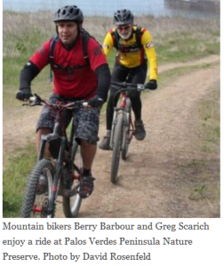
The article below is from the Easy Reader newspaper (Hermosa Beach). It details the struggles Rancho Palos Verdes mountain bikers (represented by CORBA Palos Verdes) have been having with access to local trails, dating back to 2008 (and even before that). The news is good, but it still remains to be seen until the next RPV City Council meeting on October 2. People in favor of bicycle access to Rancho Palos Verdes trails are encouraged to attend. For more information go to www.mtbpv.org/

RPV TO AMEND TRAILS USE PLAN

Mountain bikers could see more access to trails at the Palos Verdes Nature Preserve and Abalone Cove Shoreline Park and Ecological Preserve if, as expected, the Rancho Palos Verdes City Council decides the matter Oct. 4. (Info incorrect, actual date is Oct. 2–CORBA)

The proposal drew lots of public input last May when it first came before the council after a series of public workshops earlier in the year that drew around 40 people each. Several speakers opposed the additional access for bikers, causing the council to reconsider the issue until after the summer.

The original trails use plan for most of the 1,400-acre nature preserve went into effect in 2009 after a nearly two-year process led by a committee of citizens and public officials. Now the non-profit Palos Verdes Peninsula Nature Conservancy, which oversees the property, wants to designate trails on a remaining 190-acre portion known as Filiorum.

The opportunity also opened the door to revise the existing trails plan on the rest of the preserve, said Danielle LeFer, conservation director. In all, mountain bikers will potentially regain access to two trails in the Portuguese Bend area and four trails in the Abalone Cove area.

“I know mountain bikers would like to see more trails open to bikes,” said LeFer. “We incorporated all the comments we received and responded to those. Based on all of those, and discussions with rangers and city staff, we came up with some recommended changes.”

When the issue comes back to the council next month, little will have changed from what was presented in May, said Ara Mihranian, deputy director of community development for RPV.

“There are other groups out there that have their own agendas who are asking the council to make changes, but that’s not what’s being recommended by staff,” Mihranian said.

Long-time mountain biker Troy Braswell said he’s concerned the council could reverse a lot of the hard work accomplished in 2009. But council member Susan Brooks said that’s not the case.

The council postponed its decision so it could become more familiar with the preserve, Brooks said.

“The community had been working on this, but I think a lot of us were not aware of just how intensely they have been,” Brooks said. “Now that I’ve come to see just how much work has been done in the ensuing years, it really gives me a new respect for the process that has already taken place and we need to respect that.”

Brooks said RPV bears the burden of managing all the parks on the peninsula with no additional funding aside from city coffers.

“We have over 40,000 residents and we’re the largest city on the hill, but we bear the responsibility for all the parks and all the recreational facilities,” Brooks said. “Is RPV supposed to be the playground for all of the LA basin?”

By designating the trails, conservationists hope to limit impacts to the natural terrain as well as conflicts with different users. Since June 18, a ranger hotline received 55 calls, mostly about off-leash dogs said Katie Howe, parks and recreation administrative assistant.

“It’s helping to keep us aware of what’s going on in the preserve,” Howe said.

So far no calls have come in with conflicts regarding horses or mountain bikers, Howe said.

Gordon Leon, who formerly chaired the city’s equestrian committee, said the trails plan has worked pretty well.

“The trails are integral to the semi rural nature of Rancho Palos Verdes,” Leon said. “We have enviably one of the best trail networks certainly in the South Bay and to a greater extent Los Angeles. I think we’ve come to a reasonably amicable solution.” ER

CORBA comments on Topanga General Plan

Monday, January 23rd, 2012

Topanga State Park General PlanAs we reported last year, a new Topanga General Plan is being developed by California State Parks. The plan will guide Topanga State Park’s future, ensuring that management practices are in line with the mission and objectives of the Park.

The general plan does not govern trail use designations, and instead defers to the Santa Monica Mountains Trails Master Plan, which is still in development.

The current draft of the plan was released in December.  The public comment period ends today, January 23, 2012.  Below are the comments that CORBA is submitting. Members of the public are also welcome to comment on the plan, which can be found at http://parks.ca.gov/?page_id=25956.


February 23, 2012

Luke Serna, Environmental Coordinator
Topanga General Plan Team
California State Parks
Southern Service Center
8885 Rio San Diego Drive, Suite 270
San Diego, CA 92108

Re.:  Topanga State Park General Plan

Dear Mr. Serna,

Thank you for the opportunity to comment on the Topanga State Park General Plan. We have been involved in the process from the first public hearings, and are happy to see the plan approach its final iterations.  We congratulate you and the staff for moving the plan forward.  However, as CORBA represents off-road cyclists, there are a few items and omissions in the current draft about which we have some concerns.

1.  We read on page 49 “Eight additional focus group meetings were held to better understand a few site specific issues.” Then number 5 on page 50 mentions a focus group on user conflicts. CORBA as an organization representing off-road cyclists was not made aware of, and did not attend any such focus group. Nor did any of our members or anyone we can find in the bicycling community. There aren’t any details of who called the group or how that group’s findings may have affected the final plan. Without cyclists present, we are concerned that an unbalanced representation of user conflicts may have been made. Exclusion of one user group from such a focus group cannot possibly foster multi-use principles, just as excluding a user group from a trail furthers and deepens user conflicts when they do occur. Please document and clarify the process used to form this focus group and its findings as they pertain to the general plan. This would perhaps be suitable for inclusion as an appendix.

2. On page 65, it states “1. a. This management plan will address the ability of bikes, horses and other pack animals, and fire, construction and Park vehicles to carry and spread exotic plant seed throughout the Park.”  There is no mention of hiking boots, running shoes, shoe tread, socks or clothes as a vector for the spread of exotic seed. This should also be of concern and should be addressed, especially since hikers are much more likely than cyclists to go off-trail where they can be exposed to more seed than would otherwise be encountered by those staying on the trail. We feel this is an omission.

3. Page 53 states that “trail-use designations are not part of this plan…. However, trail corridors, as well as trail goals and guidelines, will be established as a part of this process.”  While these “trail corridors” appear in the legend of the map on page 105, the scale of the map and the visual indicators used in the legend do not allow for the easy identification of or distinction between “corridors” and existing trails.  A verbal description of each trail corridor proposed and/or a larger scale map would do much to alleviate and prevent any confusion. We feel we cannot adequately comment on the proposed trail corridors without fully understanding them.

4.  In Table 3, “Planning Matrix” on page 113, the Lagoon, Watershed Zone and Lower Topanga zones are listed as being restricted to “hiking on designated trails only.” To list an entire zone off-limits to other user groups will hamper the efforts to complete the Coastal Slope trail as it is envisioned–a multi-use long distance trail–that will pass through that zone. The Coastal Slope trail itself appears on the Lower Topanga/Lagoon Preferred Plan “Range of possible features” on page 115.  Making trail use decisions on a trail-by-trail basis, rather than a blanket closure of an entire area, will allow for better management of users in the area, and reduce impediments to the planned Coastal Slope Trail.

5.  According to the plan Musch Campground is open to bicycles.  However, the Musch Trail is currently closed to bicycle use. A formal change-in-use request has been submitted to convert that trail to multi-use including bicycles. How is Musch Campground currently accessed by bicycles?

Off-road cycling is a healthy outdoor recreational activity that entices people away from their couches and computers and into our treasured open spaces. Cyclists comprise a large portion of State Park visitors, yet only fire roads and Rogers Road are currently open to bikes in Topanga SP, concentrating bicycles on fewer trails, and placing them on wide fire roads that encourage high rates of downhill speed. This contributes to user conflicts and creates further divisiveness between user groups. We would like to see the General Plan recognize cycling as a legitimate, welcomed and, when managed appropriately, sustainable activity in Topanga State Park.

CORBA has a long history with State Parks in the Santa Monica Mountains. Our trail crew volunteers have worked on Rogers Road and many other trails in neighboring State Park units for many years. We note in the plan that there is a recommendation to continue to work with volunteer and non-profit groups. We work side-by-side with other user groups at State Trails Day and other events. CORBA works constantly to educate, inform and encourage off-road cyclists to practice good trail etiquette, and the vast majority do. We look forward to continuing and furthering our relationship with Topanga State Park and other SP units in the Santa Monica Mountains.

Thank you,

Concerned Off-Road Bicyclists Association

New San Vicente Mountain Communications Tower Public Presentation (the Nike Site)

Thursday, January 12th, 2012
A new communications tower is being proposed for the top of San Vicente Mountain, near the location of the Nike site at Westridge and Mulholland in the Santa Monica Mountains. This is a highly popular destination for trail users and visitors to the Santa Monica Mountains.

UltraSystems, a company specializing in environmental planning, will be conducting a public  presentation on the project for interested parties:

7:00 p.m., Tuesday, January 17, 2012, West Los Angeles City Council Office, 1645 Corinth Ave., Second Floor Hearing Room, LA, CA 90025.  

The presentation will help the public and the trail user communities understand exactly what the impacts of this new 200′ tower will be.

While this meeting will concentrate solely on the the San Vicente Mountain project, at least four other sites are being proposed for similar projects.  Mount Lee is within Griffith Park, behind the Hollywood sign and is off-limits to cyclists.

The other peaks are Mount Lukens in the Angeles National Forest, Verdugo Peak at the top of  Hostetter Fire Road (AKA “La Tuna”), and the Baldwin Hills.  The Mount Lee and Baldwin hills projects are for new equipment buildings within existing facility boundaries. Mount Lukens and Verdugo Peak are both slated to have existing towers replaced and upgraded. These projects will be discussed at a later meeting.

COSCA Strategic Plan Public Workshop Sep 20

Tuesday, September 13th, 2011

The Conejo Open Space Conservation Agency will host a public workshop to solicit your comments as a basis for developing a strategic plan for the open space and trail system of the Conejo Valley. The public is invited to provide their opinions and thoughts about the mission of COSCA, as well as their vision of how the open space and trail system should develop in the future. Click here to visit COSCA’s website.

DATE: Tuesday, September 20 from 7:00 PM – 9:00 PM

WHERE: Conejo Recreation and Park District Headquarters, Board Room 403 West Hillcrest Drive, Thousand Oaks, CA 91360

CONTACT: Shelly Austin, COSCA Associate Planner, saustin@toaks.org or (805) 449-2339.

Third Public Meeting for Topanga State Park General Plan on June 14th

Tuesday, May 24th, 2011

California State Parks is inviting the public to the third public meeting for the Topanga State Park General Plan. The purpose of this meeting is to present the single (preferred) plan and support materials. After the presentation, the General Plan team, comprised of CSP landscape architects environmental scientists, historians, archaeologists and park staff will be available to discuss this preferred plan. The single plan was developed with the input received at the first and second public meetings held in September 2009 and July 2010.

Following the third public meeting, the General Plan team will prepare the preliminary General Plan which will then be available for public review and comment as per the California Environmental Quality Act (CEQA) process.

After the completion of the CEQA process, the General Plan Document will be presented to the California Parks and Recreation Commission which will entail a public hearing process including additional opportunity for public comment.

A General Plan is mandated for state parks units by the Public Resources Code. The plan becomes the primary management document for a unit of the State Park System, establishing its purpose and management direction for the future. The plan does not provide specific physical designs but does provide a vision for the park and guidelines for future development.

Meeting location:

June 14, 2011 (Tuesday)

6:30 pm to 8:00 pm

Stewart Hall @ Temescal Gateway Park

Sunset Blvd. & Temescal Canyon Road

Pacific Palisades

Topanga State Park General Plan Meeting #3

Friday, June 3rd, 2011

California State Parks is holding its third public meeting to determine the new general plan for Topanga State Park on June 14 at Temescal Gateway Park in Pacific Palisades. Mountain bikers who use Topanga State Park and surrounding trails in the Santa Monica Mountains National Recreation area are strongly encouraged to attend the meeting and comment on the plan. For details click here Scan 4.

LA County Draft Trails Manual Public Hearing

Tuesday, March 1st, 2011

LA County Draft Trails ManualOn February 28, 2011, about 50 people gathered in the beautiful Birch Room at Descanso Gardens in La Canada. We were there to review and comment upon the most recent draft of the Los Angeles County Trails Manual. But let’s back up a bit…

Last July, CORBA board members met with LA County Planning and Sapphos Environmental (the contractor developing the Trails Manual for the County), in a Mountain Biker only public forum. At that meeting only three CORBA board members attended, the County representatives, and nobody else. The Equestrian-only meeting had many more participants, as did the Hiker-only meeting. Since this document will not set any policy regarding trail designations, Sapphos deemed it more productive to hold separate meetings with each user group. Each group gave their input on what they’d like to see covered in the trails manual, and their special concerns.

At that time in July 2010 there was only one section of the trails manual available for review: the section concerning trail design standards. Most of the standards in that preliminary section were adapted from IMBA’s Trail Solutions book, and other reputable multi-use trail construction texts. It was to be a technical document on building and designing trails, with no influence on the contentious issues around trail user groups and trail designations.

The County’s stated policy and goal is to accommodate all user groups on all trails possible. It is a multi-use, bike-friendly policy that works. We were informed at that time that there would be another round of public hearings as the manual was developed, based on the input from user groups at these meetings. The Manual is being developed with a grant from Supervisor Antonovich’s 5th district, in which the vast majority of the County’s trails can be found. The County has never had any offical trail standards, and many of the older trails are not really sustainable by today’s standards. However, this document would NOT be applied retroactively to existing trails, but will serve as the reference for all new trails that come before the County. It is likely that many of the 88 cities in Los Angeles County will also adopt this manual for their own standards once it is ratified by the County Board of Supervisors.

Fast forward to the February 28, 2011 public hearing. Steve Messer, and CORBA member/local cycling promotor and activist Dorothy Wong attended the meeting, along with about 40 local equestrians and hikers. For a welcome change from other meetings in which CORBA has been involved, the biggest issues raised were not contentious user conflicts, but rather, design standards pertaining to potentially flawed trail designs and citations from outdated Equestrian studies and facility designs.

(more…)

Palos Verdes Upper Filiorum Reserve – Public Hearing

Wednesday, September 8th, 2010

Urgent! Mountain Bikers – We need your help!

Support access for bicycles in the newly acquired Upper Filiorum Reserve. Don’t let us get shut out!   The workshop is an informal way to express your views in a small group. This is not a council meeting.

Attend the Wednesday Sept 8th workshop at Fred Hesse Community Park (map). Input from the workshop will be used to develop a plan that will determine what trails will be kept and who will be allowed to use them. The workshop starts at 6:30 PM.  Spread the word.  See points to make and trail list below. Please let us know you will attend –  Email info@mtbpv.org

Information available on line – Filiorum workshop.

We believe that these trails will provide an excellent multi-user experience for all trail users, including mountain bikers, who have only a few options left in Portuguese Bend.

  • It provides variety and loops.
  • Trails provide low use density alternative.
  • Use density will likely remain low because of steepness of entry trails.
  • We need access from Portuguese Bend to Three Sisters.
  • We could mention how few trails are available for bike in PB. Only 5 trails and 2 fire roads, 7 out of 22. That’s less that a third.
  • Access should not be denied unless there is clear and measurable cause.
  • CORBA will offer to assist rangers educate cyclists.
  • Cyclists can provide volunteers to help repair and maintain trails where bikes are allowed.

However if someone at the table brings up something negative we should be ready to provide the facts:

  • User conflict, based on a June 30, 2007 PVPLC user survey, is low:
    “Overall, there was very little conflict reported between user groups. 95% of the respondents answered that they had experienced no conflicts that day, and 87% had not experienced any past conflicts. Considering the large number of visitors using the Preserve, these numbers express an overall tolerance and peaceful coexistence between the different types of users.”
  • Equestrians claim entitlement – The survey indicated that only about 1% of users in the reserves are equestrians.
  • Trail escalation – Rangers will patrol trails.
  • Safety – Although challenging , all trails are usable by cyclists. There have been few, if any, reported accidents. Cyclists walk bikes if needed.
  • Segregated trails are inherently unfair.
Filiorum Trails Include      
Name   Miles      
Rattlesnake
Kelvin Canyon
Possum
Gary’s Gulch
Cut Across
Jack’s Brim
Jack’s Hat
Jack’s Summit
Troop 719 Trail
Pony Trail
Three Sisters East Fork
Three Sisters Upper Connector
Three Sisters Lower Connector
Total
  0.45
0.49
0.19
0.20
0.57
0.26
0.57
0.22
0.27
0.44
0.20
0.15
0.13
4.14


Rancho Palos Verdes Notice

Help Provide Input on the Trails at Upper Filiorum

The City of Rancho Palos Verdes and the Palos Verdes Peninsula Land Conservancy, with support from the State Coastal Conservancy and contributions from over 700 supporters in the community, added the 191-acre Upper Filiorum property to the Palos Verdes Nature Preserve on December 31, 2009. The acquisition resulted in over 900 contiguous acres of protected open space and a wildlife corridor linking the Three Sisters and the Portuguese Bend Reserves. The City Council adopted Preserve Trails Plan will need to be amended to include the Upper Filiorum trail routes and uses, and your input on the trail planning is requested.

Please join us at the upcoming workshops to provide your input on trail planning for the new portion of the Preserve.

Wednesday, Sept. 8, 2010 – obtain public feedback on potential trail routes and uses

Wednesday, Sept. 29, 2010 – review trails plan based on September 8 the public input

Fred Hesse Community Park
29301 Hawthorne Boulevard, Rancho Palos Verdes
Doors Open 6pm
Meetings 6:30-8:30pm

 
Hosted by National Park Service, City of Rancho Palos Verdes, and the Palos Verdes Peninsula Land Conservancy

For more information: Ara Mihranian aram@rpv.com 310-544-5228 www.palosverdes.com/rpv;

Lily Verdone lverdone@pvplc.org 310-541-7613 www.pvplc.org