Archive for the ‘Trail Hazards’ Category

$700,000 sought to fix trails, roads destroyed in Station fire

Wednesday, August 4th, 2010

From the Glendale News-Press and the LA Times 

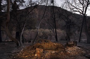
An incinerated car sits in the devastated hamlet of Vogel Flats, which is along Big Tujunga Canyon Road in the Angeles National Forest, in September of 2009 . Credit: Luis Sinco / Los Angeles Times

Roughly $700,000 has been earmarked for improving the forest roads and trails that were destroyed last year during the Station fire, officials said. 

Rep. Adam Schiff (D-Burbank) secured the earmark in the Interior Appropriations bill for restoring the 160,577 acres of scorched landscape that’s in severe need of restoration. 

“The roads and trails have been eroded and degraded,” said Richard Toyon, former forest ranger and president of the local nonprofit Volunteers Organizing in Conserving the Environment. 

Trekking on some trails in the forest is challenging because they eventually disappear, he said, and some roads and trails are no longer recognizable. 

The bill must still pass the full House and Senate before reaching President Obama’s desk, said Schiff’s spokeswoman, Maureen Shanahan. 

If the bill is approved, the funding would be allocated to the U.S. Forest Service to handle the restoration work. 

“This funding will help repair the roads and trails that were damaged in the fire to restore safety and access for families to enjoy one of California’s greatest natural resources,” Schiff said in a statement. 

Engineers for the Angeles National Forest have estimated that about 300 miles of roads and 225 miles of trails were harmed during the Station fire, according to Schiff’s office. 

Damage to roads and trails worsened due to erosion and landslides during the winter. 

Gov. Arnold Schwarzenegger on Feb. 11 declared the footprint of the fire a disaster area. 

Some of the roads have been closed due to the extensive damage, and trails that have been deemed unsafe for hiking have been off limits. 

Officials are planning to focus the funding on the most critically damaged roads with the largest access points. 

Some road improvements include installing retaining walls, reconstructing low water crossings, grading surfaces, repairing drainage, repaving and restoring signage, according to Schiff’s office. 

Trail improvements include drainage repairs, re-stabilizing slopes and restoring walking surfaces. 


Albertson and Montgomery Fireroads Graded

Thursday, July 8th, 2010

By Steve Clark

In the past few weeks, or maybe days, after the winter rains and in plenty of time for the upcoming fire season, Albertson Fireroad has been graded to a wide, smooth and slightly loose surface. Albertson Fireroad is a popular trail that starts at the east end of Lang Ranch Parkway in Thousand Oaks and continues generally eastward through the southern reaches of Simi Valley, connecting to China Flat along the way.

Today we rode from the bottom to the top, about 2.3 miles beyond China Flat. We found that a grader has been through recently, making the trail soft across more than 90% of it. This softness greatly increased our workout on the way up, but we had to be really careful not to wash out on the way down even on some very gentle curves. The surface has the consistancy of sand in some places.

There were only a very few bike tracks on the road once we were east of China Flat, suggesting that the work is very recent. From the top, we could see that the grading continued down Montgomery Fireroad into Simi Valley. It looked like Albertson Fireroad east of the fork with Montgomery (heading towards Rocketdyne)  was not graded, but that could change if the grading really took place in the last few days; it might be ongoing.

The road will be packed down through use soon enough and will then be broad, smooth and very fast. Until then, take its softer condition into account when planning your biking route.

Las Virgenes “Tar Pits” are a Natural Phenomenon

Friday, June 4th, 2010

Just three days ago a local rider contacted CORBA about an oily sheen seen in some of the still water sections and mud holes along Las Virgenes Canyon. This appeared to be a new phenomena, and the thick, dark mud and oily sheen look suspiciously like petroleum or oil products to the untrained eye. While there are oil pipes in the area, they don’t pass under the creek at this particular area, and it is somewhat alarming to come across.

Nobody at CORBA was familiar with this problem, so we alerted the MRCA. Chief MRCA Ranger Walt Young toured the area and took water samples at the three water crossings. He reported that the petroleum like sheen was present, but there was no smell of petroleum, which is common in other areas where natural seepage occurs. There was also plenty of life in the stream in the form of tadpoles and plant life.

A sample of the dark muck which has the appearance of tarry oil, dries to a fine brown powder with no evidence of the presence of oil.

The local Pipeline operator was also brought in for an assessment. Their pipes are pressurized to 500 PSI, and they noted that any leakage at that pressure would be immediately evident. There was no evidence of any leakage. Also, the dark oily-looking muck would float if it were oil-based, and there would be a strong odor of oil.

The final conclusion is that whatever seepage is there is a natural phenomenon, and is not a cause for concern. It may be the result of an above average rainfall year, or recent earthquake activity, but is not from a man-made source.

There are places in Southern California (Tar Creek in the Sespe Wilderness comes to mind) where large amounts of oil and tar do seep to the surface naturally and globs can be found floating down the stream. This reported seepage along Las Virgenes Canyon is much more subtle.

If anybody riding or hiking any trail sees anything suspicious or out of the ordinary, it is always best to contact the local land manager, law enforcement, rangers or of course you can always contact CORBA and we will notify the land manager. Thanks to rider Gary Artis for bringing this to our attention so that we could have it investigated further.

Angeles National Forest Recovery Plans

Tuesday, June 1st, 2010

There was an informational meeting on the recovery plans for the Angeles National Forest May 26, 2010 at the Eaton Canyon Nature Center.  Representatives from the U.S. Forest Service, San Gabriel Mountains Trailbuilders, the Sierra Club, TreePeople, Student Conservation Association, Caltrans, and Outward Bound were present.

The intent of the Recovery Plan is to create a more ecologically sustainable forest than before and to build a community of involved users.

There was a brief mention of San Gabriel Mountains Forever, a group the Sierra Club supports and that has the goals of promoting the proposed San Gabriel National Recreation Area and of increasing wilderness in the San Gabriels.  CORBA is investigating this wilderness proposal and its potential impact on multi-use trails.

An intern from Congressman Schiff’s office announced an upcoming informational meeting on the Rim of the Valley Corridor Special Resource Study.  The Corridor is a Santa Monica Mountains Conservancy project to expand the National Recreation Area. The meeting will be at the Nature Center at 10 am, Friday, June 4.

Mike MacIntyre, the River District Ranger for the Angeles National Forest discussed the new closure order.  Details of that are on the ANF web site.  He showed some photos of the extensive damage to the upper Arroyo Seco, Gould Mesa Road, several fire stations, Grizzly Flats Road, and Vogel Flats area.  He reported that a large boulder had been blasted from the Mt. Wilson Toll  Road near Mt. Harvard. He also confirmed that Millard campground is open, but not El Prieto, Sunset Ridge or other trails.  They are looking to open more areas by the July 4th weekend.

He noted about 35,000 acres of forested land burned, 24,000 of that was pretty much denuded and may not come back on its own.  There are plans to reforest about 11,000 acres of the 24,000.  Seedlings were not available to get started this year, and planting is expected to start with an initial 4400 acres in early 2011.  Carbon credits, grants, and Congressional sources will fund the project.<

A representative from the Tree People explained that there is a narrow window for replanting because the soil has to warm and be moist. If they wait too long it is too hot and dry for the seedlings to survive without watering, which is usually not practical.  They are recruiting and training for 2011 now.  Tree People are the lead group on the reforestation efforts.

Bob Cates reported that the Sierra Club’s Angeles Forest Restoration Project will be working on trails the 2nd and 4th Saturday of every month starting in July. They have 380 volunteers signed up. They focus on the area up Highway 39 to Crystal Lake.

The Student Conservation Association is 50+ years old, but until 2004 did not have a presence in SoCal.  They have both paid workers and non-paid volunteers. Besides doing all kinds of conservation related work, they encourage participants to consider careers in forestry, wildlife management, conservation, etc.  They have some crews working with the USFS on the fire recovery.  These crews work for several weeks at a time, so can get into back country and handle more complex jobs.

The final speaker was Patrick Chandler from Caltrans District 7.  There were 25 washouts or slides along the closed section of Highway 2.  Caltrans are hoping to have it open by mid-July.  Most of the problem was that the debris flows blocked all the drains, then the water washed across the road and off the down side eroding the shoulders and below and undermining the roadbeds. Although the engineers wanted to, they are not going to build any bridges, as there are no funds available.

Thanks to CORBA member Mitch Marich for the report.

ANF Opens Campgrounds, But Few Trails

Wednesday, May 26th, 2010

The Angeles National Forest issued a revised Closure order this week, just in time for Memorial Day weekend. While very little has been opened, campgrounds such as Horse Flats, Chilao and Millard are now open for camping.

But don’t get too excited. None of the trails around Millard (Sunset Ridge, Dawn Mine, El Prieto) are open. Work on the restoration of Sunset Ridge continues, and El Prieto has had extensive restoration work done, though according to FS officials neither are ready or safe enough for general use. Fire roads in the area are also extensively damaged.

In the Chilao area, sections of the Silver Mocassin trail are unburned and will probably be open, but the traditional figure-eight loop we all love is not possible, as the Vetter Trail and other sections of the Silver Mocassin and Hillyer trail are impassable and most likely in the closed area.

A map of the new closure order area is posted on the FS web site, though the resolution is not high enough to definitively determine which trails are officially open. They expect to have a higher resolution map available soon. In the meantime, obey all trail closure signs and be safe if you’re heading up there.

If you plan to visit the area, also remember that the Angeles Crest Highway between La Canada and Red Box remains closed. Caltrans has revised it’s projected completion of repairs, and we may see this section of highway open by the end of this summer. You need to access the Forest from Big Tujunga Canyon to Upper Big Tujunga Canyon, or via the Angeles Forest Highway to the north.

Verdugos: City Requests Illegal Features be Removed

Sunday, May 9th, 2010

At a recent meeting of the Burbank Trails Committee, City Officials notified us that illegal features that have been built along Preston Ridge in the Verdugo Mountains must be removed.

The features have appeared over the past year or two.  Near the top of the Vital Link trail (a hiker-only trail), there is a small wooden feature. Beyond that, there are some small tabletop jumps and bermed turns. The City is giving the builders until the end of May to remove the features and the materials used before they go in and take them out.

“Preston Ridge is not an official trail” according to the City representative. However, the trail was created by hikers hiking across firebreaks along the ridge line more than two decades ago. One Committee member has hiked there “his whole life.”  The City is in a dilemma as to what to do with the “trail” itself, as it has such a long use history, but has never been through any process to become an official trail. The City Attorney has determined that the features themselves are a liability.

The work on the ridge is that of many different people and groups. The City has been in contact with some of the builders, but they are only responsible for a small portion of what has been constructed.  Many of the recently altered sections of the trail were not done “up to safe, sustainable standards” and did not follow the original line of the existing unofficial but long-used trails along the ridge.

Meanwhile, CORBA has submitted a draft proposal to construct a new section of trail with mountain-bike specific features. The City Attorney and others are going over the proposal in detail, but have not yet accepted or denied the proposal. They have expressed hope that it can eventually be accepted and completed. The City needs more time to study the proposal and has requested information and examples of how other cities around the country have dealt with new mountain-bike enhanced trails.

Currently most single track trails in Burbank open space are closed to bicycles. There has not been a new official trail constructed since 1998 when the Vital Link trail was completed.

Sullivan Canyon to Experience More Closures

Wednesday, May 5th, 2010

From Sharon O’Rourke of The Gas Company.

If you’ve been through Sullivan Canyon this year, you have noticed that our maintenance road sustained significant damage from the February heavy rains.  As a result, we will have to repair the road before we resume our pipeline protection plan with the concrete mats.  Despite the rains, the concrete mats performed as expected and over time, it will be covered with natural material.

The road repair is currently scheduled to start on 5/24 and will take between 2-3 weeks.  We will close the canyon while this work takes place.  At this time we do not have a start date for the pipeline protection work so it is possible we may re-open the canyon to the public until we start the pipeline work which is currently scheduled for sometime between mid-June to mid-July.  This work, which includes laying the concrete mats to cover the remaining 12 pipeline exposure areas, is expected to take 3 – 4 months and will involve closing the canyon.

For more information go to www.socalgas.com/sullivancanyon.

Red-Flag Protocols Are Changed to Reflect Local Conditions

Monday, April 19th, 2010
 

The National Weather Service will significantly change to the way forecasters issue red-flag fire warnings, which could mean fewer such alerts for fire-prone areas from Santa Barbara to San Diego.

The changes were made after officials determined that the current red-flag protocols were not always the most accurate precursors to major fires.

For example, the National Weather Service office in San Diego issued warnings during period of low humidity — prompting fire departments to marshal resources — even though officials believe a large wildfire is unlikely there without strong winds.

By contrast, large fires in Los Angeles County can start without high winds, pointing up another vulnerability. That was the case with last year’s Station fire, which was sparked during a period of high temperatures but light winds.

The new red-flag warning system is meant to be more selective and to take into account local geography and terrain as well as wind conditions and humidity levels. San Diego County, which is highly vulnerable during strong winds, will have different criteria than Los Angeles County’s foothills and mountains.

Weather experts found that there are a lot more ways for explosive wildfires to happen in the L.A. area than in Orange to San Diego counties.

“We hope to reduce warnings for conditions we learned don’t produce large, damaging fires,” said Mark Jackson, head meteorologist for the National Weather Service in Oxnard.

The changes have major implications not just for fire departments, which often rely on the warnings to mobilize resources, but also for residents in some hillside areas, who are restricted from street parking during red-flag alerts.

The Weather Service in San Diego has enacted the new red-flag warning criteria; Oxnard is expecting to apply them as soon as the fire season begins in earnest, possibly as early as June.

The warnings are not predictions of fires but rather of the kind of conditions that are ripe for large-scale blazes.

Weather experts regularly consult with fire officials about these conditions and about the need to tweak the criteria for determining whether red-flag warnings need to be issued.

More than a year ago, fire officials urged the Weather Service to reexamine protocols for issuing the alerts.

Both in San Diego and Oxnard, weather experts conducted historical studies of the conditions that provoked and fanned large, out-of-control fires. The differences were stark from county to county.

“California has so many microclimates. It’s not a one-size-fits-all,” said Daniel Berlant, a spokesman for the California Department of Forestry and Fire Protection, which determines firefighter staffing in part based on the red-flag warnings.

Although typically drier, San Diego County has less steep terrain and sparser vegetation than L.A. County. In part because of this, the counties farther south tend to experience conditions primed for behemoth wildfires only when there are strong winds. That was the case with the deadly Santa Ana-whipped Cedar fire of 2003, which began in central San Diego County. But weather experts there said that for years, they issued warnings based on extremely low relative humidity alone.

The new criteria call for the San Diego’s Weather Service to issue red-flag warnings generally only when extremely low humidity is accompanied by winds of at least 25 mph.

“We found very few cases of large fires” when the only weather factor was low relative humidity, said Jim Purpura, head meteorologist of the National Weather Service in San Diego.

Counties farther north, including L.A. and Santa Barbara, tend to have more mountainous terrain, thicker forests and denser vegetation. When the humidity drops low enough, these conditions can lead to large fires even without vigorous winds.

That was the case with the Station fire, which last year burned more than 160,000 acres in the San Gabriel Mountains.

“The winds were mostly calm. For the most part, that was not a wind event,” said Frank Vidales, an assistant chief for the L.A. County Fire Department’s forestry division. “But it was very hot and very dry.”

In the past, criteria for calling a red-flag warning for Los Angeles County and some other areas included relative humidity of 15% or less and winds of at least 25 mph. Under new standards, those criteria can also be met with winds as low as 15 mph, as long as the humidity dips below 10%, Jackson said.

He pointed out that based strictly on those guidelines, the Station fire may not have been preceded by a red-flag warning because the winds were so weak. But Jackson said that is why forecaster discretion will remain a key part of making the ultimate call.

Jackson said that if the relative humidity is above 15% but the winds are very strong, an alert could still be issued.

“Conversely, if the forecaster feels there’s an extremely dry fuel situation, and that we’re very volatile, they can still issue that red-flag warning without winds,” he said.
Snakes ‘scared to death of us’

Wednesday, March 31st, 2010

From the Desert Sun  (Palm Springs, CA)

Rattlesnakes are coming out of hibernation in the Coachella Valley about now.

A Western Diamondback Rattlesnake is indigenous to the Coachella Valley

The best way to deal with the slithering reptiles? Leave them alone.

“Rattlesnakes don’t look for trouble,” said Jim Cornett, a desert ecologist who lives in Palm Springs and has written three books about snakes. “They’re scared to death of us.”

At this time of year, valley residents are most likely to come across snakes on hiking trails.

“The best thing to do is give them a wide berth,” he said. “Stay about 10 feet away from them and walk around them.”

Snakes often stop when people approach and attempt to blend in with their surroundings to avoid detection.

If there’s not enough room on a trail to get around a snake, Cornett said hikers could either turn around or throw a handful of sand on the snake to let it know that it has been seen.

When snakes do bite people — usually on the hand, foot or ankle — Cornett said that in about a third of cases, the snake does not actually inject venom. But the only way to know is to get to a hospital.

“Any rattlesnake bite is a medical emergency,” he said. “You must go to the hospital.”

Venom helps rattlesnakes digest their prey.

“As the venom is inside the animal’s body, it starts to digest it even before the rattlesnake swallows it,” he said. “Unfortunately, in a human, it starts digesting your tissues.”

In a small percentage of cases where a snake bite has gone untreated for more than a couple hours, Cornett said the tissue damage has been so extensive that a finger, hand or arm has had to be amputated.

Officials from John F. Kennedy Memorial Hospital in Indio said the hospital keeps enough antivenin on hand to treat one snake bite patient. The valley’s three major hospitals share their antivenin supplies with each other as needed.

Cornett said that in March, snakes are most likely to be found near the rocky crevices and burrows where they’ve been hibernating since November.

“You’re more likely to see them in April than in March because they’re out and about, and generally they’re searching for a mate,” he said. “They are going to travel well beyond their little hibernation burrow, and there are records of rattlesnakes traveling several miles.”

The snakes stay out during the day until highs reach 85 or 90 degrees and nighttime temperatures stay above 70 degrees.

“By the end of April, rattlesnakes are primarily nocturnal,” he said. “That can happen a little bit earlier if it warms up rather quickly.”

Cornett said rattlesnakes often turn up in backyards at the edge of development, sometimes looking for rodents that may abound in the area or for cool, watered ground to lie on during warm days.

But he added that any snake found in the valley without a rattle on its tail is a nonvenomous species.

“If it’s a harmless snake and you live on the edge of a suburban area, I say count your blessings,” Cornett said.

That’s because two of the harmless species common to the valley can keep venomous rattlesnakes at bay.

“Whipsnakes (also commonly known as red racers) and kingsnakes will eat small rattlesnakes, and both those harmless snakes are immune to rattlesnake venom,” Cornett said.