Archive for the ‘San Gabriel Valley’ Category

San Gabriels Protection bill Passes House

Saturday, February 22nd, 2020

Last week four bills affecting California passed the House. H.R.3820, the “San Gabriel Mountains Foothills and Rivers Protection Act”, and H.R.1708, the “Rim of the Valley Corridor Preservation Act,” were rolled into a land protection bill with four other bills including H.R. 2250. the Northwest California Wilderness, Recreation, and Working Forests Act, and the H.R.2199 Central Coast Heritage Protection Act–both of which have earned the support of local mountain biking organizations. Local mountain bike clubs and IMBA have been key players in the development of these bills. The combined bill, H.R. 2546, Protecting America’s Wilderness Act, passed the House on February 12, with 6 house republicans voting in favor.

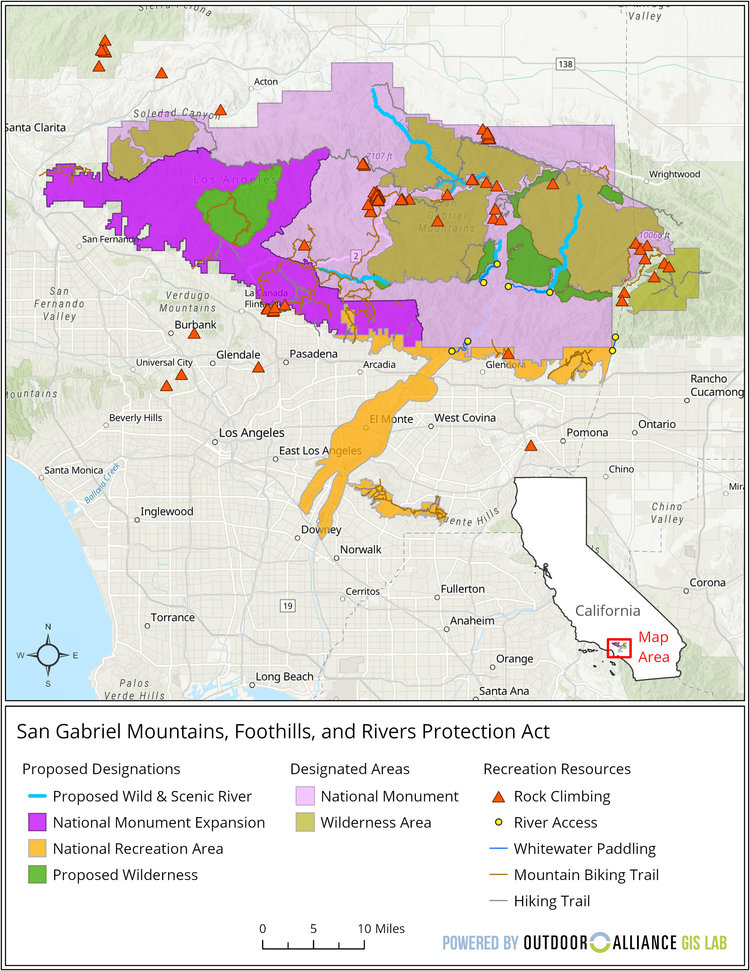
San Gabriel Mountains, Foothills and Rivers Protection Act

San Gabriel Mountains Foothills and Rivers Protection Act

San Gabriel Mountains Foothills and Rivers Protection Act Reference Map

Wilderness Expansion

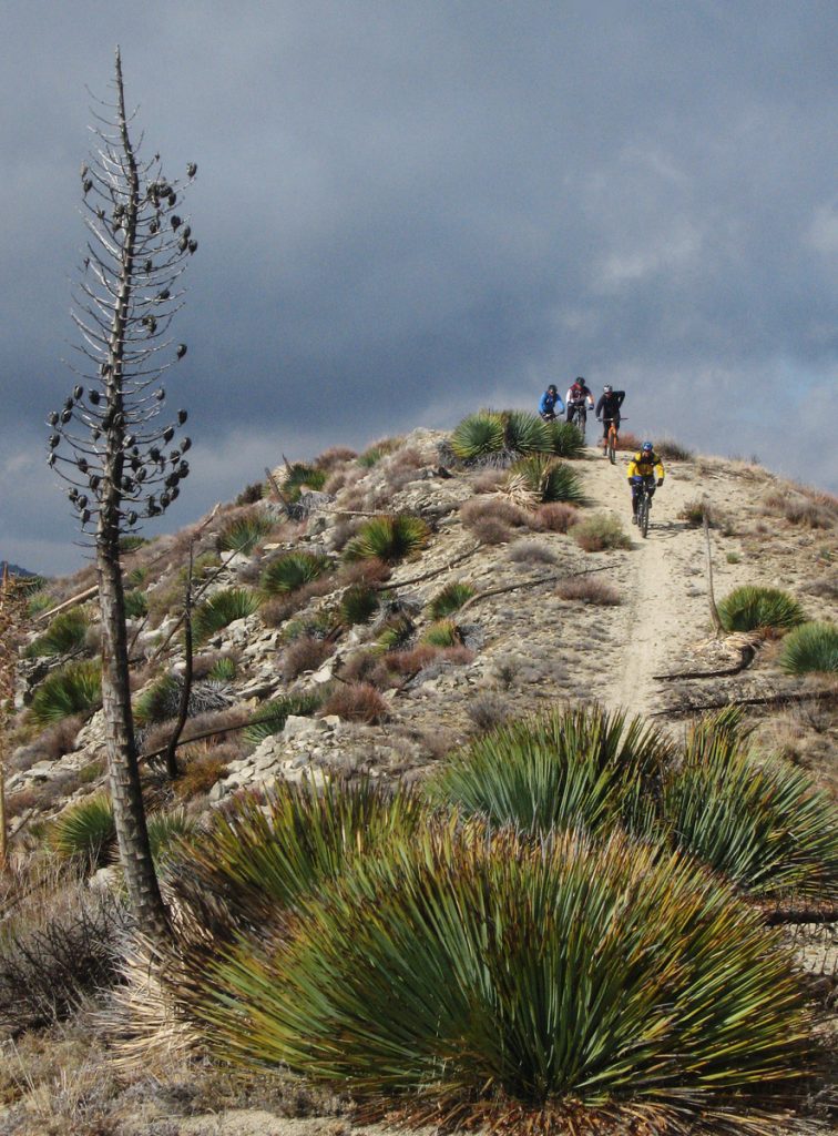
Mountain Bikers descend from Condor Peak

Protest Riders descend from Condor Peak, December 2007

H.R.3820, introduced by Judy Chu (CA-27), expands the boundaries of existing federally-designated wilderness areas within the Angeles National Forest. The bill also creates two new Wilderness areas, the Yerba Buena Wilderness and Condor Peak Wilderness.

Condor peak has long been a target for wilderness protection by environmental groups. It is also one of the last long-distance, high-elevation singletrack trails providing access to a mountain summit that remains open to bikes. It was included in a bill by Barbara Boxer, as a new wilderness area. Jim Hasenauer, then working with IMBA, led a protest ride on the trail showing that it was a high-value trail to mountain bikers on December 1, 2007. It was withdrawn from the Omnibus Public Land Management Act of 2009, but has never been forgotten by environmentalists.

CORBA worked locally with The Wilderness Society, Sierra Club and CalWild on the language and boundaries of the current bill for more than two years. Concurrently, IMBA worked at the national level and in Washington DC, to ensure that the proposed Wilderness areas would have no impact to existing trails open to mountain bikes.

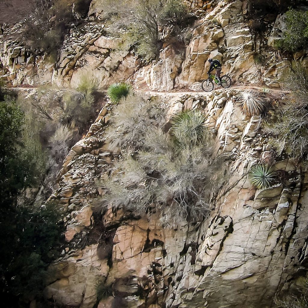
Condor Peak trail is a steep, exposed and challenging backcountry trail.

For mountain bikers, Condor Peak trail was not up for negotiation. While we support protecting the character of the area, we wanted to ensure not only that bicycles could continue to access it, but also that mechanized maintenance (using chainsaws or other powered tools) would continue to be allowed. We’ve seen many trails that have been closed to bikes by Wilderness designations slowly deteriorate as volunteer groups cannot keep up with the existing trail maintenance backlog, and the Angeles National Forest has no trail crew of its own.

The solution we reached was to propose two Wilderness Areas on each side of the trail. The resulting legislation passed last week in the House creates the Yerba Buena and Condor Peak Wilderness areas, separated by a 100′ buffer through which the Condor Peak trail passes. Trail Canyon trail, the only other trail within the proposed Wilderness boundary, is cherry-stemmed out of the Wilderness allowing bicycle access to Trail Canyon falls and the nearby campground. A portion of the upper Trail Canyon trail, which has not been passable by bicycle in decades, will fall within the new wilderness boundary.

CORBA chose not to oppose this latest bill as it had no impact to mountain bike access. However, we could not support it fully, as it does nothing to enhance our mission of improving and increasing trail access for mountain bikes. We remain neutral on the bill, but if it passes, we will remain fully engaged in its implementation to further keep the interests of mountain bikers represented. 

There are two amendments being sought by CORBA and IMBA. Due to what appears to be a mapping error, three switchbacks along the Mt. Waterman trail dip a few dozen feet into the Wilderness area.  Though the Forest Service manages it as a non-wilderness trail, an amendment to the bill, by inserting “fifty feet south of the Mt. Waterman Trail” into the legal description of the wilderness area boundary, would correct that. 

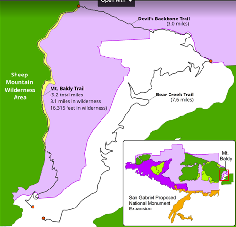
Proposed Boundary Adjustment

Proposed Boundary Adjustment

The other amendment we are seeking is more challenging. The eastern Boundary of the Sheep Mountain wilderness passes directly over the summit of Mt San Antonio (AKA Mt. Baldy).  It is the only one of three peaks in Southern California over 10,000′ and above treeline to which bicycles have access (via the Devil’s Backbone trail). Wilderness advocates wanted to expand the Wilderness boundary eastward, entirely enveloping the Bear Creek trail in Wilderness.  The trail follows the Wilderness boundary, lying just inside the boundary by 25 yards. The trail would completes an incredibly challenging, high-elevation, backcountry loop. We are seeking an amendment to move the boundary 75′ west of the trail, removing it from wilderness, and opening the loop to bicycles. The boundary remains unchanged in the current legislation. 

These two amendments would remove approximately 75 acres of existing wilderness in a bill that adds over 31,000 acres of new Wilderness. These will be difficult asks for some, but we feel the ride loop this boundary adjustment would create a truly unique experience that is attainable nowhere else.

National Monument Expansion

The bill also expands the boundary of the San Gabriel Mountains National Monument, which was declared in October 2014. The boundary expansion makes sense geographically, as one of the biggest challenges in developing the current Monument management plan (as a Forest Management Plan Amendment) was the allocation of district-specific resources.

The Forest Service felt growing pains as they transitioned from three districts to one district and a National Monument (which is managed as a district). The Monument designation left out the most historically significant and most visited section of the Angeles National Forest, which includes the front country trails south and west of Mt. Wilson, and Mt. Lukens, and areas south of Big Tujunga. There was confusion among Forest Service staff when a vehicle, for example, was assigned to the district, but was stationed physically much closer to the Monument. It has taken years, but those challenges have been largely sorted out.

This time around, the bill requires the development of a management plan within three years (the plan amendment for the SGMNM took almost four years to complete). The current Monument designation had no impact to trail access for mountain bikes, and has brought in some additional funding and additional attention to our local mountains. In fact, IMBA and CORBA worked closely with the White House in 2014 to ensure that mountain biking was specifically mentioned in the monument proclamation ensuring its future acceptance. As a result, visitorship has steadily increased since the 2014 designation.

San Gabriel National Recreation Area

The third section of Chu’s bill will create a new National Park Service unit in the San Gabriel Valley. The San Gabriel National Recreation Area would become a new unit of the National Park service. It would comprise land along the foothills of the San Gabriel Mountains and corridors along the San Gabriel, Rio Hondo, and other rivers and open spaces in the San Gabriel Valley.

The proposed NRA would not change any land ownership, nor restrict any current land owner from managing their land (and their trails) as they are already doing. It allows willing landowners or land managers within the NRA boundary to partner with the NPS to improve recreation, habitat connectivity, water quality, wildlife corridors and public access. It doesn’t change any existing trails, and has the potential to bring additional federal resources to local projects.

With all these aspects of the bill, our biggest concern is that the agencies managing lands the bills protect are not adequately funded at a level necessary to do their job effectively. Creating additional financial obligations by the Forest Service and National Park Service, when current budgets are falling short, will bring its own set of challenges.

H.R.3820 has a companion bill in the Senate, S.1109, introduced by Senator Kamala Harris. We will continue to work towards those amendments in the Senate version of the bill, which will face a tougher challenge under the current administration. If the bills fail this year, we expect them to be reintroduced in future sessions of congress.

A fact sheet from Judy Chu’s office can be found at https://chu.house.gov

Rim of the Valley Corridor Protection Act

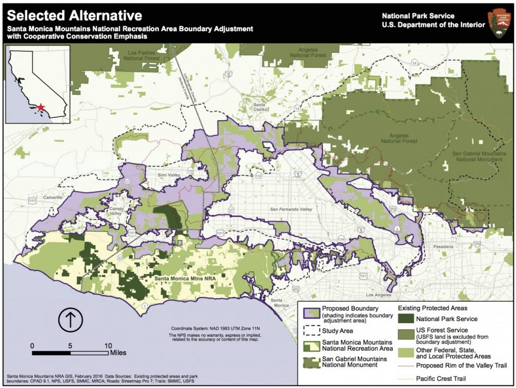
H.R.1708 was introduced by Congressman Adam Schiff, after several years where similar legislation failed to make it out of committee. The Rim of the Valley Corridor Preservation Act will expand the boundary of the Santa Monica Mountains National recreation area. The expanded boundary will include the mountains surrounding the Santa Clarita, San Fernando, Simi, La Crescenta and Conejo valleys. These include the Santa Susana Mountains, the Simi Hills, the Verdugo Mountains, and other adjacent lands and river corridors as shown below.

Rim of the Valley Corridor Map

The act does not change the current management of any land or trails within the expanded boundary. What it will do is allow willing landowners or land managers to partner with the NPS on projects that may enhance recreational access, improve habitat and wildlife connectivity, or provide capital improvements. It does not take land away from any existing landowners, nor does it force existing land managers to partner with the National Park service in any way. It has no downsides for mountain biking, and has the potential to improve trail access.

CORBA’s original mission statement and our operational boundary was defined as “the Rim of the Valley Corridor.” This bill is therefore very much at the heart of CORBA’s mission.

The bill was the outcome of a six-year feasibility study, authorized by an act of Congress in 2008. The study began in 2010, with CORBA engaged throughout the six-year process, attending public meetings, providing expert testimony and public comments, and encouraging public discourse and engagement in the process.

The study sought to determine if the area possess nationally significant natural or cultural resources; whether it is it a suitable and unique addition to the National Park System; whether it is feasible to add it to the Park System; and does it require direct NPS management, instead of stewardship from other groups or a public-private combination? The answer to the first three questions was Yes. Since the study concluded in 2016, legislation has been introduced twice without success. Last week the bill passed the House. In December, the Senate Committee on Energy and Natural Resources passed the Rim of the Valley Corridor Preservation Act, moving it one step closer to the Senate floor.

We are fortunate in Southern California to have one of the most mountain bike friendly NPS units in the country, the Santa Monica Mountains NRA. Currently all National Park service managed singletrack trails in the Santa Monica Mountains are open to bicycles. In fact, the only trails closed to us are closed by the Boney Mountain State Wilderness, and California State Parks. We expect the NPS to continue supporting a multi-use trail policy in the expanded NRA. In fact, all of the land managers within the expanded boundary, with the exception of the City of Los Angeles, are multi-use friendly.

Lands within the Angeles National Forest are specifically excluded from the expanded NRA. The Forest Service and the National Park Service already have an arrangement in which they are able to share resources for the benefit of our public lands under the Service First authority, which was made permanent in 2012.

For these reasons we are supportive of the expanded boundary of the Santa Monica Mountains NRA in the current legislation. However, to our knowledge there is no additional budget allocated to the expanded NRA, nor to the new San Gabriel NRA in Chu’s bill. For these reasons we have been reluctant to throw our full support behind the bills as they can be considered unfunded (or underfunded) mandates. If these bills pass, we will advocate for increased funding, and will remain engaged with land managers in the development of their management plans, and to identify opportunities for creating or improving multi-use trails and mountain bike access.

The Rim of the Valley trail was originally envisioned by Marge Feinberg in the 1960s as a trail that encircles the San Fernando Valley, connecting communities with their local mountains. The trail itself is being piecemealed together as opportunities present themselves. The vision of a trail led to a broader vision to protect the mountains surrounding our valleys, and ultimately to H.R.1708. It has been a forty-year effort to protect the mountains that define our valleys.

A fact sheet on the bill can be found at https://schiff.house.gov

Glendora Seeks Public Input on Little Dalton Wash Multi-Use Urban Trail

Tuesday, September 24th, 2019

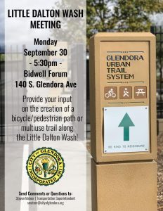
The City of Glendora invites you to a public workshop held in conjunction with a proposed grant application to the California Natural Resources Agency under Proposition 68.  The City is proposing to submit an application for the Little Dalton Wash. The project would construct a bike/pedestrian path similar to the existing Glendora Urban Trail and extend from Finkbiner Park to just south of the spreading grounds near Glendora Mountain Road. The City will be holding a workshop to solicit input and feedback on this exciting opportunity to create and enhance open space, trail connectivity, and recreational opportunities for Glendora, on Monday, Sep 30th.

CORBA supports the proposal, and we encourage everyone with an interest in the Colby trail, the city of Glendora, and its urban trail system to participate in the public meeting:

Little Dalton Wash Meeting
Monday, September 30, 2019, 5:30 – 7:30pm
Bidwell Forum, 140 S. Glendora Ave, Glendora, CA


Public Meetings Dec 5: Rosemead Blvd and East Fork San Gabriel Canyon

Thursday, November 30th, 2017

On Tuesday, December 5th there are two conflicting public meetings of interest to those who ride bicycles in the San Gabriel Mountains or the San Gabriel Valley.

San Gabriel River Confluence with Cattle Canyon Improvements Project

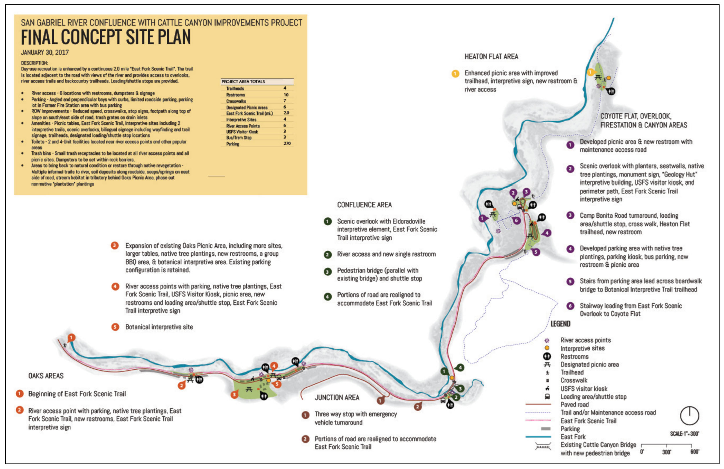
The other public meeting is to seek public input on the Draft Environmental Impact Statement (DEIS) for the San Gabriel River Confluence with Cattle Canyon Improvements Project. CORBA, through our involvement with the San Gabriel Mountains Community Collaborative, have expressed our full support for the project as proposed.

Click to Enlarge

This project will add much-needed trailhead improvements, interpretive and scenic trails, parking, bike racks, shuttle stops, multilingual signage, river access points and habitat restoration to this heavily-impacted area of the Forest. While not heavily used by mountain bikers, all of us who care about our Forest are supportive of these improvements.

The project is within the San Gabriel Mountains National Monument, and is being developed in partnership with the Watershed Conservation Authority. The meeting will be held at the Angeles National Forest headquarters:

Tuesday, December 5, 2017
5:30 p.m. to 7:30 p.m.
Angeles National Forest Headquarters
701 N Santa Anita Ave,
Arcadia, California 91006

Comments must be submitted by December 26, 2017, to:

EFSGR/Cattle Canyon Improvements Project
110 N. Wabash Ave.
Glendora, California 91741

or via email to: EFSGR@wca.ca.gov


LA County Rosemead Blvd Complete Streets Project

LA County’s Rosemead Blvd Complete Streets project proposes to add bike lanes, pedestrian walkways and other improvements to Rosemead Blvd through the Whittier Narrows area. This is the initial scoping meeting, where the County will be seeking public input on how to best improve this six-lane stretch of road to better accommodate cyclists and pedestrians. The meeting will be held at the More information can be found at:

Tuesday, December 5, 2017, 6:00 – 8:00 p.m.
Pico Rivera Municipal Golf Course,
3260 Fairway Dr.,
Pico Rivera, CA 90660.

http://dpw.lacounty.gov/pdd/proj/rosemeadcs/

This project will have great value to our community, as it will improve safety for pedestrians and cyclists accessing the Whittier BMX track, Whittier Narrows recreation area, and existing bike paths along the San Gabriel River and Rio Hondo. It is also close to the proposed Puente Hills Landfill, with its two planned and approved Bike Skills Parks.

We can’t be at both meetings, but want to encourage those with an interest in either to attend these meetings and be engaged in the process.

Report on the San Gabriel Watershed and Mountains Special Resources Study

Thursday, September 3rd, 2009

September 3, 2009
by Steve Messer

Last night Hans Keifer, Steve Messer and Jim Hasenauer attended the public comment meeting put on by the National Park Service in Santa Clarita. The following is a summary of the presentation and our thoughts, concerns and feedback on the study.

History:

This study was mandated by Congress through a bill introduced by Hilda Solis back in about 2002 and passed in 2003. The study began in 2005, but this is the first much of the public has heard of the process, including me and other CORBA and IMBA volunteers. The study area includes much of the San Gabriel mountains, as well as the San Gabriel Watershed. The watershed includes the San Gabriel River drainage area within the national forest, as well as cities along the river and its watershed such as El Monte, Hacienda Heights, La Habra, Brea, Walnut, West Covina, Baldwin Park, Monrovia, La Verne,  and the Puente-Chino Hills area. See more on the study and the process.

Study Area:

The goal of the first stage of the study was to determine:

1. the “Significance” in biological, historical and recreational terms, of the study area.

2. the “Suitability” of the area for inclusion in the National Park system. That’s to say that it fills a gap in the National Park system that can’t be filled by anything else… ie. its uniqueness.

3. The “Feasibility” of bringing it into the National Park system in some manner.


So far the study has found that there is Significance worthy of national park protection. The mountains, the biodiversity, the unique geological character, architecture and history all make it significant.

There is “Suitability” in that there is nothing else quite like it already within the National Park System.

It was deemed to be infeasible to make any of the study area a National Park. There are too many land owners and land managers, too many private holdings even within the National Forest, and in many respects, would be re-inventing the wheel to start from scratch with what the Forest service has already accomplished in managing the forest.

However, it would be feasible for the National Parks service to come in and participate in the management and development of the area, in collaboration with the Forest Service and other land managers in the study area.

Of particular concern to us, as mountain bikers, is the continued access to the trails to which we have access, the possibility of new trails being built, and to avoid any further wilderness designations.

The final goal of the study is to present to congress a report on the Significance, Suitability and Feasibility of the area, and make a final recommendation as to the most effective and efficient way for the NPS to be involved in the management of the San Gabriel Mountains and San Gabriel River watershed.

What is not covered at this stage of the study is what happens after the study is complete.

Once the final recommendation is made, it would then be up to congress to decide what to do with the recommendation. Of particular note is that Hilda Solis is now Labor Secretary, and is no longer involved in the committee that would be receiving the results of the study she helped start. The recommendation may linger on a shelf and never be implemented, or it may get picked up, brought to committee, a further recommendation made to the full house, and then may or may not pass.

This introduces some concerns. Alternative A and Alternative C both have the largest federal presence, and both would require an act of Congress to implement. Whenever an act of congress is proposed, it will be debated and most likely amended. Amendments may introduce language to weaken our position as mountain bikers, to introduce more wilderness legislation, or to to pander to certain special interest groups with large lobbying powers. It opens the door for a whole range of uncertainties in the implementation of the plan.

But that scenario would be a long way off. The study is still (four years along) at a very preliminary stage. They expect to have the draft proposal ready in a year, another round of public meetings and comments, and present their findings to congress in 2011.

Several times during the presentation and the Q&A group sessions, it was expressed that the NPS would continue to allow the Forest Service to manage the forest, and other land managers would continue to manage their own jurisdictions. From our point of view as mountain bikers, this seems good policy, since the Forest Service has just spent five years or so developing the Forest Management Plan <http://www.fs.fed.us/r5/angeles/projects/ForestPlan.shtml> in which the most productive use of the forest was deemed to be Recreation. It sounded like the Forest Service would be able to continue to implement that plan, which is not at odds with the concept of a “National Recreation Area.”

Jim, Hans, and myself split up and each joined a different discussion group. Nowhere was there any strong or vocal anti-mountain bike sentiment, and in Jim’s group four of the fifteen people were mountain bikers. My group were all hikers from Santa Clarita who wanted more trails and access from the northern slopes of the San Gabriels, which are greatly under-utilized in comparison to the more populated southern slopes. There was no equestrian presence, but a few in my group said that the equestrians were supportive and would be doing a letter writing campaign. Given the past positions of the Equestrian Trails, Inc. (ETI), their campaign will likely be very anti-mountain bike.

But this meeting wasn’t really about what people wanted more or less of (trails, signage, interpretive centers, etc) though that is what came up most in the group discussions. It was about how the forest and watershed would be managed, and the alternate proposals for how that partnership would function. Management includes the ability to meet the needs and provide the resources that the public want, something that just isn’t presently happening given the current financial situation of the FS. 85% of their budget presently goes to fire management (well spent at the moment) leaving little for improvements.

To summarize the three alternative plans:


Alternative A
, the forest would get the largest involvement by the NPS, the largest land area that would be covered (most of the Lower Angeles National Forest) and management would come mostly from the National Forest Service with assistance, input, and funding from the NPS. This seems to us, as the better option, with less agencies involved, more land area, and more funding. It incorporates most of the Southern Angeles National Forest, and little outside the forest.

Alternative B would have the NPS creating a Master Plan for the whole area, San Gabriel mountains, rivers, all of the cities and land managers along the river and into the Chino hills. After that master plan is developed, the NPS would have little involvement, and it would be up to each individual jurisdiction to implement that master plan as a the San Gabriels Parks and Open Space Network. It includes the southern Slopes and the San Gabriel mountains and the river corridors.

Alternative C would have the NPS taking a leadership role and overseeing a partnership between the FS and the many local land managers. The area would include only the San Gabriel watershed and river corridor. This would exclude most of the current southern Angeles National forest.

There was no mention of new wilderness areas, as this is strictly a study for inclusion in a National recreation area, or Recreational Open Space area, not a wilderness study. Not much was addressed among the group discussions about the lower watershed, including the various cities and the Chino-Puente hills area, though the meetings in El Monte and Diamond bar would have had more involvement in those areas.

There is a comment period on the current presentation through October 30th. At the above web site, click on “Newsletter 4” then click on the “Comment on Document” link on the left side of the screen.

They need to hear from as many mountain bikers as possible, to ensure that we are represented as a large and growing user group of the forest. To make comments, here’s my list of my answers and talking points:

NPS Public Comment Topic Questions:

1. Is there one alternative concept or idea presented that you think is most valuable in terms of improving recreational opportunities and protecting significant resources? Tell us why you think this idea is valuable.

The inclusion of the largest land area, Alternative A, would give the most coverage and likely bring the most resources in to manage the national forest.   A combination of Alternatives A & C would provide the most coverage of important natural resources, including both mountain and river protections and opportunities for interpretation.  A combination of A & C would create a strong federal management partnership between the USFS and NPS and a strong recreational identity for the San Gabriel Mountains and watershed.


2. What suggestion do you have for strengthening or improving on the alternative concepts? Do you have an entirely different vision of how the area should be managed? If so, please describe your vision.

However, the inclusion of the lower watershed portions of Alternatives B and C, which incorporates much of the green belts along the rivers and the Chino-Puente hills, would present the most recreational opportunities to the largest number people. Perhaps some hybrid of these proposals in which the NPS and USFS manage the San Gabriel Mountains portion, and together oversee the partnership outlined in Alternative C as an open space network.

3. What concerns do you have about the current alternatives?

Recreation. The most productive use of the forest should continue to be recreation, as outlined in the current Forest Plan, and recreational access should be increased through a more streamlined process for getting new recreational projects approved. Recreational projects should be given administrative and considerational priority over commercial and other proposals, since the most productive and valuable use of the forest has been deemed recreational. We would hope that the NPS could bring in additional staff to more rapidly complete studies required by the NEPA process. These goals would seem to be in line with a National “Recreation” area.

Mountain bike access. There is a strong need for an area for mountain bike specific trails for this fast growing user group, both to take pressure off existing multi-use trails and minimize disparate user group conflicts. However, this should not be at the expense of continued access to the existing trail network, which are currently enjoyed by many thousands of mountain bikers annually with few conflicts. A mountain-bike specific area or trail network would serve a subset of the mountain bike community whose major preference is technical downhill riding, and whose need has been demonstrated by the continued construction of illegal trails that meet that need within the region. This would remain under Forest Service management within the proposal, and no NPS policy should preclude the fulfilling of this recognized need.

Protection. Wilderness designations should be actively discouraged from any recommendation, legislation or amendments to legislation, as such designations do not meet the requirements for the best recreational use or protection of wild areas. Other protections are available that allow better management and access to wild areas without compromising biological protection. Other political and user groups are seeing this study and proposal as a way to slip in more wilderness designations. This is contrary to the recreational nature of the forest and not in the best interest of the public as a whole.

Management.  The Forest Service should be allowed to continue to implement its Forest Master Plan, albeit with additional resources and funding provided by the NPS within their shared goals and objectives. They have already invested years of study into the area, and have developed a master plan that at present provides the best guideline for the management and further development of the forest.

4. What are your thoughts or comments on the study findings (significance, suitability or feasibility)?

There is no doubt among any who have hiked, mountain biked, soared (hang gliders), ridden horses, off-highway vehicles, rock climbed, or done any geological, biological  or archaeological study, that the area is significant, unique, and worthy of including in the NPS system.

The biggest concern then becomes the addition of an additional layer of bureaucracy when trying to make improvements in access, recreational opportunities or facilities. Based on information in the presentation, those concerns appear to be minimized in the present proposals. The political manipulation of legislation that may be introduced as a result of the study favoring one user group over another, or one type of biological protection over another, then becomes the major future consideration, and that is largely beyond the scope of the present study.

Summary and Future:

There is nothing presently in the study that would threaten mountain bike access to the Naitonal Forest. In fact, all indications are that the increased funding and NPS administrative assistance, as Alternatives A and C would provide, would be beneficial to all forest user groups. Perhaps some hybrid of the alternatives would be best. The NPS will hopefully determine that from the comments and meetings.

At present, we should keep monitoring the web site <http://www.nps.gov/pwro/sangabriel> for changes and updates. The newsletters (Currently number 4) outline the progress of the study and explain each of the currently proposed alternatives in detail, including the vision, concept, management structure and funding.

Post your comments to the NPS web site as mentioned previously, and feel free to use what has been provided above or to elaborate or put your own thoughts into words.

The next round of public meetings will take place once the draft proposal is ready (Q4 2010), and we’ll have the opportunity to make our voices heard again then.

San Gabriel Watershed and Mountains Special Resource Study

Monday, August 24th, 2009

August 24, 2009

From the National Park Service, http://www.nps.gov/pwro/sangabriel/index.htm

The National Park Service is conducting a “special resource study” of portions of the San Gabriel River watershed and the San Gabriel Mountains. Our current newsletter presents several draft alternative concepts for the area, each of which offers a different collaborative, partnership-based approach to resource protection and public use and enjoyment, while respecting existing land management and ownership. You may download newsletter #4 from this web site or you may request a printed copy from our office. If you would like to provide comments on the newsletter online, click here.

In a special resource study, a proposed addition to the national park system receives a favorable recommendation from the National Park Service only if it meets all of the following criteria:

  • it possesses nationally significant natural or cultural resources;
  • it is a suitable addition to the system;
  • it is a feasible addition to the system; and
  • it requires direct NPS management, instead of alternative protection by other public agencies or the private sector.

We will be hosting five public meetings between August 31 and September 15 in cities throughout the study area. The schedule is listed below. Please join us at one of the public meetings to learn more about the draft alternative concepts, and to share your ideas, thoughts and concerns. Your comments by mail, e-mail and internet are welcome through October 30, 2009.

Public Meeting Locations and Times

We look forward to meeting you and hearing your ideas and comments at one of the following public meetings:

(Note: Because of the Station Fire burning in the area, some of these meeting times or locations may be changed. Check here for updates!)

El Monte (map)
Monday, August 31st
7pm – 9pm
City of El Monte Senior Center
3120 N. Tyler Avenue
Diamond Bar (map)
Wednesday, September 2nd

7pm – 9pm
Diamond Bar Center Ballroom
1600 S. Grand Avenue

Santa Clarita (map)
Thursday, September 3rd

7pm – 9pm
George A. Caravalho Activities Center
Santa Clarita Room A
20880 Centre Point Parkway

Glendora (map)
Monday, September 14th

7pm – 9pm
Glendora Public Library
140 South Glendora Avenue
Palmdale (map)
Tuesday, September 15th

7pm – 9pm
Larry Chimbole Cultural Center,
Lilac Room
38350 Sierra Highway

As directed by Congress in July 2003 (P.L. 108-042) , the National Park Service (NPS) is conducting a “special resource study” of portions of the San Gabriel River and its tributaries from the city of Santa Fe Springs to the north, and the San Gabriel Mountains within the territory of the San Gabriel and Lower Los Angeles Rivers and Mountains Conservancy. This area includes portions of the Angeles National Forest, as well as many communities along the San Gabriel River. Many people, organizations, and agencies are working to conserve resources in this area to provide recreational opportunities, habitat restoration, watershed improvement, and flood protection. This study is intended to build on and complement the efforts that are underway.

Quick links:


Monrovia Citywide Park Master Plan – Public Meeting April 13

Thursday, April 6th, 2017

The City of Monrovia wants to hear from residents and stakeholders. How can they better meet your recreational needs?

Monvovia Hillside Wilderness Preserve

Monrovia has started work on a new citywide Park Master Plan. The new Plan will establish a path forward for providing high quality, community-driven parks, trails, natural areas, and recreation services serving Monrovia.

For Monrovia residents and stakeholders, it’s an important opportunity to ask for better quality trails and improved connectivity at Monrovia Hillside Wilderness Preserve. Or you might want to ask for a pump track or bike park., or any number of other options.  You have to show up and ask if you want them badly enough!

The City is holding a public meeting, and will also be taking input through the MySidewalk app.

If you’re a Monrovia stakeholder and have ideas for

Public Meeting: Thursday, April 13, 2017

Monrovia Community Center
119 W. Palm Ave., Monrovia, 91016
April 13, 2017
7 p.m. – 9 p.m. 

Learn more at http://www.cityofmonrovia.org/recreation/page/citywide-park-master-plan