Archive for the ‘Regions’ Category

Sullivan Canyon reopens November 6th

Thursday, November 5th, 2009

November 5, 2009
by Sharon O’Rourke, Public Affairs Manager, The Gas Company

The Gas Company is pleased to announce it is completing the first phase of it’s planned work in Sullivan Canyon by Friday, November 6, 2009.  The maintenance road has been re-established and 10 pipeline exposures have been covered with protective revetment mats.  The maintenance road now has the articulated concrete mats (revetment mats) in a few areas of the roadway to provide protection and covering for the pipelines.  The public should exercise caution when crossing these areas with the revetment mats.  By November 6th, the construction equipment and vehicles will be removed as well as ending the guard service.Minor work to hydro-seed vegetation in certain areas will start the week of November 16th and last for approximately 2 weeks.  This work will be during weekdays only from 8am – 5pm.  The canyon will remain open to the public while this work is proceeding as cones will be placed and signage will be posted as a safety precaution due to the presence of vehicles and to protect the newly seeded areas.  Occasionally a water truck may be used to water these areas to help the growth of the new plantings.

We want to thank the public for its patience and courtesy while we worked to ensure the safe operation of our pipelines.  The second phase of our project will start next year approximately in the spring to cover the remaining pipeline exposure areas and to finish the planting of vegetation and the sycamore seedlings.

We also wanted to share with you that our security guard, stationed at the northern end of the canyon, observed a small brush fire off of dirt road Mulholland on Friday, Oct. 31st at approximately 11 p.m.  The fire was caused by a mylar balloon (silver metallic balloon) that was loose and touched the power line, creating sparks that set off a small brush fire.  Our guard called 9-1-1 to report the fire which brought an immediate response from the Los Angeles Fire Department’s air and land crews.  The fire was limited to 1/2 acre. We are thankful that this guard was diligent, alert and responded quickly by calling in the Fire Department.

Physician convicted in bicycle crash case

Tuesday, November 3rd, 2009

November 3, 2009
from the Los Angeles Times

A physician accused of deliberately injuring two cyclists by slamming on his car’s brakes on a narrow Brentwood road was convicted Monday of mayhem, assault with a deadly weapon and other serious criminal charges.


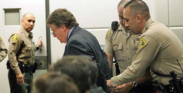
Dr. Christopher Thompson is handcuffed by L.A. County Sheriffs after being found guilty on all 7 counts. (Mel Melcon / Los Angeles Times / November 2, 2009)

Dr. Christopher Thompson, 60, slumped forward and held his face in his hands after the verdicts were announced in a courtroom packed mostly with supporters and cyclists.

Deputy Dist. Atty. Mary Stone, who prosecuted the case, asked for Thompson to be jailed immediately, calling him a flight risk and a safety threat to cyclists.

“There’s not a cyclist in Los Angeles who would feel comfortable with this defendant out on the road after this verdict,” Stone told the court.

Los Angeles County Superior Court Judge Scott T. Millington ordered that Thompson be taken into custody. Thompson, wearing a dark blue suit, grimaced and shook his head as a bailiff cuffed his hands behind his back.

The veteran emergency room doctor, who spent more than two decades working at Beverly Hospital in Montebello, was also convicted of battery with serious injury and reckless driving causing injury. He faces up to 10 years in prison when he is sentenced Dec. 3.

The three-week trial in the Superior Court’s airport branch was watched closely by bicycle riders around the country, many of whom viewed the case as a test of the justice system’s commitment to protecting cyclists. The July 4, 2008, crash also highlighted simmering tensions between cyclists and motorists on Mandeville Canyon Road, the winding five-mile residential street where the crash took place.

Prosecutors alleged that Thompson stopped his car after passing the two cyclists and shouting at them to ride single file. The cyclists testified that they began maneuvering to ride one after the other when they noticed Thompson’s car approaching fast behind them but that the driver passed dangerously close before abruptly stopping.

Ron Peterson, a coach for USC’s and UCLA’s cycling team, was flung face-first into the rear windshield of the doctor’s red Infiniti, breaking his front teeth and nose and lacerating his face. Christian Stoehr, the other cyclist, hurtled to the sidewalk and suffered a separated shoulder.

A police officer testified that Thompson told him soon after the accident that the cyclists had cursed at him and flipped him off, so he slammed on his brakes “to teach them a lesson.”

Thompson testified that he never meant to hurt the riders. He said he and other residents were upset at unsafe cycling along the road, which has become an increasingly popular route for bicycle riders in recent years. But they had struggled to identify problem cyclists.

Thompson told jurors that the riders cursed at him and flipped him off when he yelled at them to ride single file. He stopped his car so that he could take a photo of the cyclists and believed he had left enough room for them.

But prosecutors alleged Thompson had a history of run-ins with bike riders, including a similar episode four months before the 2008 incident, when two cyclists told police that the doctor tried to run them off the road and braked hard in front of them. Neither of the riders was injured.

Outside court, the cyclists in the case said they were relieved at the outcome.

“Our hope is that this brings to light how vulnerable cyclists are out there,” Peterson, 41, told reporters. His face was permanently scarred from the crash and he underwent reconstructive surgery on his nose, which he said remains numb.

Stoehr, 30, said the crash left him unable to work for months and that he rarely rides his bike anymore. Nevertheless, Stoehr said he felt some sympathy for Thompson as he watched the physician being led away in handcuffs.

“It’s sad for both sides,” Stoehr said. “I lost a lot of my time and my life, and he’s losing a lot of his.”

Report on the San Gabriel Watershed and Mountains Special Resources Study

Thursday, September 3rd, 2009

September 3, 2009
by Steve Messer

Last night Hans Keifer, Steve Messer and Jim Hasenauer attended the public comment meeting put on by the National Park Service in Santa Clarita. The following is a summary of the presentation and our thoughts, concerns and feedback on the study.

History:

This study was mandated by Congress through a bill introduced by Hilda Solis back in about 2002 and passed in 2003. The study began in 2005, but this is the first much of the public has heard of the process, including me and other CORBA and IMBA volunteers. The study area includes much of the San Gabriel mountains, as well as the San Gabriel Watershed. The watershed includes the San Gabriel River drainage area within the national forest, as well as cities along the river and its watershed such as El Monte, Hacienda Heights, La Habra, Brea, Walnut, West Covina, Baldwin Park, Monrovia, La Verne,  and the Puente-Chino Hills area. See more on the study and the process.

Study Area:

The goal of the first stage of the study was to determine:

1. the “Significance” in biological, historical and recreational terms, of the study area.

2. the “Suitability” of the area for inclusion in the National Park system. That’s to say that it fills a gap in the National Park system that can’t be filled by anything else… ie. its uniqueness.

3. The “Feasibility” of bringing it into the National Park system in some manner.


So far the study has found that there is Significance worthy of national park protection. The mountains, the biodiversity, the unique geological character, architecture and history all make it significant.

There is “Suitability” in that there is nothing else quite like it already within the National Park System.

It was deemed to be infeasible to make any of the study area a National Park. There are too many land owners and land managers, too many private holdings even within the National Forest, and in many respects, would be re-inventing the wheel to start from scratch with what the Forest service has already accomplished in managing the forest.

However, it would be feasible for the National Parks service to come in and participate in the management and development of the area, in collaboration with the Forest Service and other land managers in the study area.

Of particular concern to us, as mountain bikers, is the continued access to the trails to which we have access, the possibility of new trails being built, and to avoid any further wilderness designations.

The final goal of the study is to present to congress a report on the Significance, Suitability and Feasibility of the area, and make a final recommendation as to the most effective and efficient way for the NPS to be involved in the management of the San Gabriel Mountains and San Gabriel River watershed.

What is not covered at this stage of the study is what happens after the study is complete.

Once the final recommendation is made, it would then be up to congress to decide what to do with the recommendation. Of particular note is that Hilda Solis is now Labor Secretary, and is no longer involved in the committee that would be receiving the results of the study she helped start. The recommendation may linger on a shelf and never be implemented, or it may get picked up, brought to committee, a further recommendation made to the full house, and then may or may not pass.

This introduces some concerns. Alternative A and Alternative C both have the largest federal presence, and both would require an act of Congress to implement. Whenever an act of congress is proposed, it will be debated and most likely amended. Amendments may introduce language to weaken our position as mountain bikers, to introduce more wilderness legislation, or to to pander to certain special interest groups with large lobbying powers. It opens the door for a whole range of uncertainties in the implementation of the plan.

But that scenario would be a long way off. The study is still (four years along) at a very preliminary stage. They expect to have the draft proposal ready in a year, another round of public meetings and comments, and present their findings to congress in 2011.

Several times during the presentation and the Q&A group sessions, it was expressed that the NPS would continue to allow the Forest Service to manage the forest, and other land managers would continue to manage their own jurisdictions. From our point of view as mountain bikers, this seems good policy, since the Forest Service has just spent five years or so developing the Forest Management Plan <http://www.fs.fed.us/r5/angeles/projects/ForestPlan.shtml> in which the most productive use of the forest was deemed to be Recreation. It sounded like the Forest Service would be able to continue to implement that plan, which is not at odds with the concept of a “National Recreation Area.”

Jim, Hans, and myself split up and each joined a different discussion group. Nowhere was there any strong or vocal anti-mountain bike sentiment, and in Jim’s group four of the fifteen people were mountain bikers. My group were all hikers from Santa Clarita who wanted more trails and access from the northern slopes of the San Gabriels, which are greatly under-utilized in comparison to the more populated southern slopes. There was no equestrian presence, but a few in my group said that the equestrians were supportive and would be doing a letter writing campaign. Given the past positions of the Equestrian Trails, Inc. (ETI), their campaign will likely be very anti-mountain bike.

But this meeting wasn’t really about what people wanted more or less of (trails, signage, interpretive centers, etc) though that is what came up most in the group discussions. It was about how the forest and watershed would be managed, and the alternate proposals for how that partnership would function. Management includes the ability to meet the needs and provide the resources that the public want, something that just isn’t presently happening given the current financial situation of the FS. 85% of their budget presently goes to fire management (well spent at the moment) leaving little for improvements.

To summarize the three alternative plans:


Alternative A
, the forest would get the largest involvement by the NPS, the largest land area that would be covered (most of the Lower Angeles National Forest) and management would come mostly from the National Forest Service with assistance, input, and funding from the NPS. This seems to us, as the better option, with less agencies involved, more land area, and more funding. It incorporates most of the Southern Angeles National Forest, and little outside the forest.

Alternative B would have the NPS creating a Master Plan for the whole area, San Gabriel mountains, rivers, all of the cities and land managers along the river and into the Chino hills. After that master plan is developed, the NPS would have little involvement, and it would be up to each individual jurisdiction to implement that master plan as a the San Gabriels Parks and Open Space Network. It includes the southern Slopes and the San Gabriel mountains and the river corridors.

Alternative C would have the NPS taking a leadership role and overseeing a partnership between the FS and the many local land managers. The area would include only the San Gabriel watershed and river corridor. This would exclude most of the current southern Angeles National forest.

There was no mention of new wilderness areas, as this is strictly a study for inclusion in a National recreation area, or Recreational Open Space area, not a wilderness study. Not much was addressed among the group discussions about the lower watershed, including the various cities and the Chino-Puente hills area, though the meetings in El Monte and Diamond bar would have had more involvement in those areas.

There is a comment period on the current presentation through October 30th. At the above web site, click on “Newsletter 4” then click on the “Comment on Document” link on the left side of the screen.

They need to hear from as many mountain bikers as possible, to ensure that we are represented as a large and growing user group of the forest. To make comments, here’s my list of my answers and talking points:

NPS Public Comment Topic Questions:

1. Is there one alternative concept or idea presented that you think is most valuable in terms of improving recreational opportunities and protecting significant resources? Tell us why you think this idea is valuable.

The inclusion of the largest land area, Alternative A, would give the most coverage and likely bring the most resources in to manage the national forest.   A combination of Alternatives A & C would provide the most coverage of important natural resources, including both mountain and river protections and opportunities for interpretation.  A combination of A & C would create a strong federal management partnership between the USFS and NPS and a strong recreational identity for the San Gabriel Mountains and watershed.


2. What suggestion do you have for strengthening or improving on the alternative concepts? Do you have an entirely different vision of how the area should be managed? If so, please describe your vision.

However, the inclusion of the lower watershed portions of Alternatives B and C, which incorporates much of the green belts along the rivers and the Chino-Puente hills, would present the most recreational opportunities to the largest number people. Perhaps some hybrid of these proposals in which the NPS and USFS manage the San Gabriel Mountains portion, and together oversee the partnership outlined in Alternative C as an open space network.

3. What concerns do you have about the current alternatives?

Recreation. The most productive use of the forest should continue to be recreation, as outlined in the current Forest Plan, and recreational access should be increased through a more streamlined process for getting new recreational projects approved. Recreational projects should be given administrative and considerational priority over commercial and other proposals, since the most productive and valuable use of the forest has been deemed recreational. We would hope that the NPS could bring in additional staff to more rapidly complete studies required by the NEPA process. These goals would seem to be in line with a National “Recreation” area.

Mountain bike access. There is a strong need for an area for mountain bike specific trails for this fast growing user group, both to take pressure off existing multi-use trails and minimize disparate user group conflicts. However, this should not be at the expense of continued access to the existing trail network, which are currently enjoyed by many thousands of mountain bikers annually with few conflicts. A mountain-bike specific area or trail network would serve a subset of the mountain bike community whose major preference is technical downhill riding, and whose need has been demonstrated by the continued construction of illegal trails that meet that need within the region. This would remain under Forest Service management within the proposal, and no NPS policy should preclude the fulfilling of this recognized need.

Protection. Wilderness designations should be actively discouraged from any recommendation, legislation or amendments to legislation, as such designations do not meet the requirements for the best recreational use or protection of wild areas. Other protections are available that allow better management and access to wild areas without compromising biological protection. Other political and user groups are seeing this study and proposal as a way to slip in more wilderness designations. This is contrary to the recreational nature of the forest and not in the best interest of the public as a whole.

Management.  The Forest Service should be allowed to continue to implement its Forest Master Plan, albeit with additional resources and funding provided by the NPS within their shared goals and objectives. They have already invested years of study into the area, and have developed a master plan that at present provides the best guideline for the management and further development of the forest.

4. What are your thoughts or comments on the study findings (significance, suitability or feasibility)?

There is no doubt among any who have hiked, mountain biked, soared (hang gliders), ridden horses, off-highway vehicles, rock climbed, or done any geological, biological  or archaeological study, that the area is significant, unique, and worthy of including in the NPS system.

The biggest concern then becomes the addition of an additional layer of bureaucracy when trying to make improvements in access, recreational opportunities or facilities. Based on information in the presentation, those concerns appear to be minimized in the present proposals. The political manipulation of legislation that may be introduced as a result of the study favoring one user group over another, or one type of biological protection over another, then becomes the major future consideration, and that is largely beyond the scope of the present study.

Summary and Future:

There is nothing presently in the study that would threaten mountain bike access to the Naitonal Forest. In fact, all indications are that the increased funding and NPS administrative assistance, as Alternatives A and C would provide, would be beneficial to all forest user groups. Perhaps some hybrid of the alternatives would be best. The NPS will hopefully determine that from the comments and meetings.

At present, we should keep monitoring the web site <http://www.nps.gov/pwro/sangabriel> for changes and updates. The newsletters (Currently number 4) outline the progress of the study and explain each of the currently proposed alternatives in detail, including the vision, concept, management structure and funding.

Post your comments to the NPS web site as mentioned previously, and feel free to use what has been provided above or to elaborate or put your own thoughts into words.

The next round of public meetings will take place once the draft proposal is ready (Q4 2010), and we’ll have the opportunity to make our voices heard again then.

August 31 Public Meeting on Sullivan Canyon Closure

Tuesday, September 1st, 2009

A community meeting is scheduled for Monday, August 31 at 7pm at the WLA Municipal Center (1645 Corinth Ave, LA 90025) arranged by the Brentwood Community Council and Councilmember Rosendahl’s staff.  Southern California Gas Company representatives will explain their project in greater detail and provide attendees an opportunity to ask their questions. The gas company still plans to close their canyon property to the public beginning September 1, 2009 and expect to re-open the canyon when the work is complete.

Dirt Rag Magazine Credits CORBA with first volunteer mountain bike patrol group

Tuesday, September 1st, 2009

September 1, 2009

In an article on the history of IMBA‘s National Mountain Bike Patrol (NMBP), Dirt Rag magazine reviews the role CORBA had in spearheading volunteer mountain bike patrols. To quote:

“Although the NMBP was officially ‘started’ in 1994, volunteer mountain bike patrol’s roots run deep, back to the early days of mountain biking, when trails were rife with user conflict, and blanket mountain bike bans threatened great riding locations from coast to coast. The Concerned Off-Road Bicyclists Association (CORBA) was arguably the first organization to begin volunteer patrol activities with their Mountain Bike Unit (MBU), formed in 1988.

“Based in the Santa Monica Mountains, near Los Angeles, CORBA was at risk of losing many great riding venues. ‘Due to frequent complaints about user conflict, land managers were throwing their hands up,’ explains Blumenthal. ‘The [mountain bike advocacy] toolkit had to be developed quickly.’ So, with support from the National Park Service and the California State Department of Parks and Recreation, the patrol was formed, and became an overnight success, being nominated for the ‘Take Pride in California Award’ in 1991.”

Read the entire article, 15 Years of Service: A Look Back at IMBA’s National Mountain Bike Patrol.

San Gabriel Watershed and Mountains Special Resource Study

Monday, August 24th, 2009

August 24, 2009

From the National Park Service, http://www.nps.gov/pwro/sangabriel/index.htm

The National Park Service is conducting a “special resource study” of portions of the San Gabriel River watershed and the San Gabriel Mountains. Our current newsletter presents several draft alternative concepts for the area, each of which offers a different collaborative, partnership-based approach to resource protection and public use and enjoyment, while respecting existing land management and ownership. You may download newsletter #4 from this web site or you may request a printed copy from our office. If you would like to provide comments on the newsletter online, click here.

In a special resource study, a proposed addition to the national park system receives a favorable recommendation from the National Park Service only if it meets all of the following criteria:

  • it possesses nationally significant natural or cultural resources;
  • it is a suitable addition to the system;
  • it is a feasible addition to the system; and
  • it requires direct NPS management, instead of alternative protection by other public agencies or the private sector.

We will be hosting five public meetings between August 31 and September 15 in cities throughout the study area. The schedule is listed below. Please join us at one of the public meetings to learn more about the draft alternative concepts, and to share your ideas, thoughts and concerns. Your comments by mail, e-mail and internet are welcome through October 30, 2009.

Public Meeting Locations and Times

We look forward to meeting you and hearing your ideas and comments at one of the following public meetings:

(Note: Because of the Station Fire burning in the area, some of these meeting times or locations may be changed. Check here for updates!)

El Monte (map)
Monday, August 31st
7pm – 9pm
City of El Monte Senior Center
3120 N. Tyler Avenue
Diamond Bar (map)
Wednesday, September 2nd

7pm – 9pm
Diamond Bar Center Ballroom
1600 S. Grand Avenue

Santa Clarita (map)
Thursday, September 3rd

7pm – 9pm
George A. Caravalho Activities Center
Santa Clarita Room A
20880 Centre Point Parkway

Glendora (map)
Monday, September 14th

7pm – 9pm
Glendora Public Library
140 South Glendora Avenue
Palmdale (map)
Tuesday, September 15th

7pm – 9pm
Larry Chimbole Cultural Center,
Lilac Room
38350 Sierra Highway

As directed by Congress in July 2003 (P.L. 108-042) , the National Park Service (NPS) is conducting a “special resource study” of portions of the San Gabriel River and its tributaries from the city of Santa Fe Springs to the north, and the San Gabriel Mountains within the territory of the San Gabriel and Lower Los Angeles Rivers and Mountains Conservancy. This area includes portions of the Angeles National Forest, as well as many communities along the San Gabriel River. Many people, organizations, and agencies are working to conserve resources in this area to provide recreational opportunities, habitat restoration, watershed improvement, and flood protection. This study is intended to build on and complement the efforts that are underway.

Quick links:


Mt Lowe Truck Trail Closure

Friday, June 19th, 2009

June 19, 2009

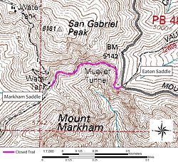
Due to a recent rock slide, the section of the Mt. Lowe Truck Trail (Forset Trail No. 2N50) is closed from its intersection with Eaton Saddle, continuing west 1/2 mile to its intersection with Markham Saddle as shown in the picture. The trail was closed starting on June 9th and the closure is in effect until June 8, 2010.

A 150 foot portion of the Mt. Lowe Truck Trail collapsed during a rock slide making it dangerous for public access. The rock slide has created a narrow section requiring trail users to traverse on a narrow section with loose gravel and soil. The remainder of the trail will remain open with signs posted at the beginning and end of the trail in addition to signs at the actual slide area.

Angeles Chapter of the Sierra Club works to keep mountain bikes off trails in Los Angeles

Monday, June 1st, 2009

Chapter activists working to keep city parks hiker-friendly and mountain-bike free

By Carol Henning, Co-Chair, Southern Sierran Editorial Board. The following article appears in the June 2009 edition of the Southern Sierran, Vol 65 No6.

You’re hiking down a steep trail, enjoying the view, trying to remember the name of a trailside wildflower when, whoosh! Inches from your left arm a mountain bike comes careening down the trail. Most close encounters with mountain bikes leave all parties unharmed – most, but not all.

“We have seen conflicts,” reports Kevin Regan of the Department of Recreation and Parks. There have been “close calls and accidents.” A Los Angeles City Ordinance prohibits bicycles on unpaved trails in all City parks. This ordinance was reaffirmed unanimously by the City Council in 2000. Moreover, this April, the Angeles Chapter passed a resolution supporting efforts to uphold the existing ordinance.

The backstory has been documented by Sierra Club hike leader, AI Moggia. 1995 saw the Concerned Off Road Bicycle Association (CORBA) requesting access to dirt trails in city parks from the Department of Recreation and Parks (DRAP), whereupon a Mountain Bike Task Force was formed including CORBA, DRAP, the L.A. Department of Transportation (LADOT and the L.A. Bicycle Advisory Committee (BAC). The L.A. City Planning Department spooned up this alphabet soup and other entities to formulate a Bicycle Plan Element. In 1996, the DRAP Commission denied requests for a mountain bike event in Griffith Park, citing the municipal ordinance and an opinion by the City Attorney. Also in 1996, the City Council adopted the Bicycle Master Plan as part of the Transportation Plan Element of the General Plan of L.A. City.

DRAP, CORBA, DOT and BAC studied the feasibility of opening City parks to mountain biking.

In 1998, LADOT City Bicycle Coordinator Michelle Mowery and BAC member Alex Baum made a special presentation to DRAP. There was minimal public notice of three community meetings in 1999, but over 400 residents attended. 95 percent of the attendees expressed their opposition to biking on city parks’ dirt trails. Despite the apparent dearth of public support, Elysian Park was selected in January 2000 for a mountain bike pilot program. Word of mouth and work by the Citizens’ Committee to Save Elysian Park brought out more members of the public to a meeting at Grace Simons Lodge, where they opposed the mountain bike pilot program. A subsequent meeting brought out more community members, a vast majority of whom opposed the program. Elysian Park was spared, and the City Council passed the motion rejecting changes to the ordinance prohibiting mechanized use of City park trails.

Mountain bike advocates tightened the straps on their helmets and soldiered on. Perhaps feeling jilted by Recreation and Parks, they decided to hop onto the handlebars of the Department of Transportation. But is this not an issue of recreation rather than transportation? The DOT’s Bicycle Master Plan is about cycling in the City. The focus is presumably on the transportation aspects of the bicycle plan, not on the thrills of jouncing down a narrow dirt trail, dodging (one hopes) hikers, runners and equestrians.

A September, 2008, memo by Jordann Turner, Bike Plan Project Manager, wondered “why and how the meetings in the past between cyclists/equestrians/etc. have been contentious.” Might it have been those accounts of clobbered hikers, frightened horses and thrown riders? To avoid this sort of testimony, DOT decided to use a consultant who has experience with this subject matter to conduct small mediated working-group meetings. Attendance at these meetings was by invitation only, with no notice to the public. The Los Angeles Bike Plan Stakeholder Advisory Group consists of nine invited participants – three hikers, three mountain bikers and three equestrians. Where are the runners? Where are the dog-walkers? Where are the homeowners associations’ representatives? They were not invited to the table.

It seems clear that the question is not whether mountain bikes should be permitted in City parks but which parks should allow them and how should access be designed. Two Sierra Club members represented hikers’ interests at the first meeting. Neither was an official representative of the Angeles Chapter. After the show, the distinction between being a Sierra Club member and a designated Sierra Club spokesperson was explained to the facilitators. supposedly neutral consultants with ties to to the Osprey Group of Boulder, Colorado, whose website documents its experience securing trail access for mountain biking.)

Webmaster’s note: Michelle Mowery, Bicycle Coordinator for the LA City Dept of Transportation (LADOT) testified recently that “The Needs Assessment … identified bicycling and walking trails as the number one need. … It identifies equestrian use as last on that list. So it’s clear that there is a need and a desire for bicycle facilities within the parks.”

For more on this issue, including video clips of outrageous claims during testimony, visit our LA City Parks web page.

Club policy on mountain bikes opposes their use in officially designated wilderness areas unless determined to be appropriate by analysis, review and implementation. The Park City Agreement (1994) between the Sierra Club and the International Mountain Bicycling Association called for site-specific analyses and stated that not all non-wilderness trails should be opened to bicycle use. Of concern are the effects of off-road biking on soil erosion, the impacts on plants and animals, and the displacement of other trail users. When considering the introduction of off-pavement bikes to a park, Sierra Club guidelines mandate consideration of these issues: whether the safety and enjoyment of all users can be protected, and whether there has been a public review and comment procedure for all interested parties. In this case, the response is no.

A late 2008 DRAP Citywide Parks Needs Assessment demonstrated virtually no demand for mountain biking [Webmaster’s note: See the inset at right to evaluate the accuracy of this claim]; yet, a small advocacy group seems to be trying to sneak its agenda past an unsuspecting public. Most of us have not been invited to join the discussion, but we can make our voices heard. Send letters and e-mails to LADOT, to DRAP and to your city councilmember.

CORBA in the News: Volunteers wage weekly fight with mountain trail erosion

Sunday, April 12th, 2009

From the Ventura County Star, Sunday, April 12, 2009


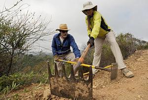
Burt Elliott, trail maintenance coordinator, leads volunteers and fellow members of the Santa Monica Mountains Trail Council to the Saturday work site. Volunteers cut back shrubs, cleared minor slides and upgraded runoff canals along a 1.4-mile stretch.

Encumbered by heavy tools, a dozen members of the Santa Monica Mountains Trails Council met Saturday morning in the dirt parking lot of a trailhead on the Backbone Trail. Their mission: trail maintenance.

Oxnard resident Dave Edwards, group leader, said the purpose of the volunteer, nonprofit organization is establishing and maintaining the public trail system throughout the Santa Monica Mountains. That’s why he and his colleagues were shouldering pickaxes, grappling with loppers (oversized pruning shears) and swinging McLeods, the five-tooth rake with a cutting edge used by California Division of Forestry firefighters. They were heading out on a two-mile hike to combat trail ruts and erosion from rain and mountain bikes by digging water bars to drain rainwater from the trial.

There also was a report of two small landslides near the mountain crest that needed to be checked out and cleared if necessary. “We spend a lot of time putting in drains,” said Edwards, 62. “Maintaining these trails gives all of us a sense of accomplishment. We may only do 300 or 400 feet (of trail) today, but we keep coming back, even though the pay is lousy.”

And they do come back — every weekend and one Wednesday a month, 10 months a year. July and August are a respite because of the heat. Edwards said they are often joined by the Santa Monica Mountains Task Force of Sierra Club or members of Concerned Off-Road Bicyclists Association (CORBA).

Burt Elliot, 76, of Thousand Oaks said he’s been a Trails Council member “going on 17 years.” “I hike, run and mountain bike the trails,” he said, striding briskly up an incline. “I’m a retired engineer, and I like to build things. It’s also neat to have a relationship with the park. Our crew leaders are actually unpaid staff.”


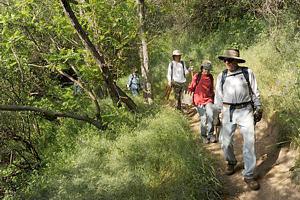
CORBA members Steve Clark of Newbury Park and Claudia Mitchell of Oxnard team up Saturday to groom Backbone Trail with the Santa Monica Mountains Trail Council.

At age 22, Celina Armenta was one of three in the group not eligible for AARP membership. Edwards said a lot of Trails Council members are retired, giving them more free time. Armenta drove from Downey to join the group for the first time. She graduated from UC Santa Barbara, but only recently became interested in hiking. “I’m not much of a hiker. I grew up in Los Angeles, where everything is flat,” she said between gasps for air. “All these older people can outhike me. They tell me how to fix the trail and the names of flowers and I say, ‘Cool.’ I definitely want to do this some more,” she added. “And I’m going to make my lazy friends come out here — forget the YMCA.”

Armenta said she might bring her friends to meet her new hiking friends at the 28th Santa Monica Mountains Trail Days — 2009. The three-day event will kick off April 24 at Point Mugu State Park. It’s a weekend devoted to building new trails and restoring old ones in partnership with the Trails Council, California State Parks, CORBA, California Native Plant Society, the National Park Service, Santa Monica Mountains Natural History Association, Temescal Canyon Association, Santa Monica Mountains Task Force of Sierra Club and Conejo Sierra Club. Camping is free for trail workers. All volunteers are welcome; trail work experience is not required. Camp will be at the Danielson Ranch multiuse site under sycamore and oak trees in the heart of the park.

For more information, call 818-222-4550 or visit http://www.smmtc.org. More photos are available in the VenturaCountyTrails.org photo gallery.

Jeff Klinger, chairman of CORBA, responds to the statement in this article that “trail ruts and erosion… [are caused by] rain and mountain bikes”

The article indicates that the trail erosion was caused by two factors: rain and mountain bikes. Identifying one user group without mentioning the array of factors that contribute to erosion does not fairly portray that group and implies that erosion is somehow use-specific, when it is not.

Independent studies demonstrate that mountain bikes cause no more surface erosion than other types of trail use. And, many factors contribute to the erosion of trails, including natural and human sources. Water causes the most damage to trails, as it is the most erosive force of nature (that’s how we got the Grand Canyon). All trail recreation has some impact, however that impact is increased or decreased as a result of many factors, including trail design. Sustainable trail design and properly constructed water control features serve to minimize erosive effects of nature and trail users.

The bottom line is that trails are built by people primarily for recreational use. Because trails are unprotected by vegetation and exposed to the elements, particularly concentrated rainwater erosion and continuous plant growth into the open trail space, trails must be maintained or they will erode away and be overtaken by vegetation. Hiking and biking groups such as the Santa Monica Mountains Trails Council and Concerned Off-Road Bicyclists Association take a leadership role and deploy volunteer teams year-round to maintain these precious resources for the community to enjoy. We welcome everyone to come out and join us.

COSCA Seeks Volunteers for Trailhead Outreach

Monday, March 2nd, 2009

March 2, 2009

The Conejo Open Space Trails Advisory Committee (COSTAC) of the Conejo Open Space Conservation Agency (COSCA) needs two volunteers for any of the Trails Outreach events. These events are scheduled for Saturday or Sundays from 8:30 to 11:00 a.m. at various COSCA trailheads (see below). The volunteers will provide information to hikers, mountain bikers and runners about the Conejo Open Space, such as

  • trail maps
  • hike and event schedules
  • environmental education
  • COSCA volunteer opportunities

Training is provided on site on the day of the event.

Please email Steve Forman (Outreach Coordinator) if you would like to help out on any of these dates forman3d@hotmail.com

March 7th: Los Robles (south end of Moorpark Rd.)
May 16; Lang Ranch
June 27: Los Robles
October 3rd: Wildwood