Archive for the ‘Angeles National Forest’ Category

Recreation and The Future of Conservation

Tuesday, March 19th, 2013

As CORBA prepares for discussions about wilderness proposals in the Angeles National Forest, we found the following Tedx Talk by Brady Robinson, Executive Director of the Access Fund, timely and relevant.

One of CORBA’s missions is to protect and preserve the open spaces and public lands on which we pursue our joint passions for cycling and nature. While we feel that our open spaces need protection from development and other activities that would forever change the landscapes we love so much, doing so in a way that precludes future bicycle access, or takes away existing public, multi-use trails is something that we and the growing off-road cycling community have difficulty supporting.

Robinson’s assertion that we tend to protect that with which we are familiar rings so true. If we never get our younger generations to experience nature in a way that is compelling and entices them to return, we’ll all have a much harder time convincing them of the need to protect our public lands. He says: “By remembering what we love and why we love it, we find the inspiration to protect it and nurture it for future generations.”

After watching the video, let us know what you think.


TEDxBoulder – Brady Robinson – Recreation and the Future of the Conservation Movement from Access Fund.

Learn more about this TedxBoulder talk here.

Why? Good Question!

Tuesday, February 26th, 2013

20120421111-Malibu-Creek-State-Park-Hike-Bike-Run-Hoof-300x199

By Mark Langton

It was recently brought to our attention that newly elected president of Equestrian Trails, Inc. (ETI) Robert Foster, a retired law enforcement officer, donates his time as an emergency medical technician at So Cal High School Mountain Bike Racing League races. Mr. Foster is a staunch supporter of the league, and in his president’s message in ETI’s most recent newsletter he stated that it’s a new era in our public open space trail systems, and mountain bikers are part of the trail user community so we all should try to figure out ways to get along.

Now I’ve been doing this advocacy thing for over 25 years, and I’ve experienced a lot of encouraging progress in the areas of shared use, especially when it comes to opening more trails to bicycle use. To hear the president of an organization that has historically had some of its members rally against mountain bikes say that we need to get along is truly groundbreaking. But things like this come fewer and more far between than I’d like, and during these 25 years I have often asked myself “why am I doing this?” The answer is always “because it’s the right thing to do.” This might sound insane (insanity once being defined by Albert Einstein as “doing the same thing over and over again and expecting different results), and in many ways this might be true. But then something like Robert Foster’s reasonable position comes along and I think to myself, maybe we have been doing the right thing after all.

Over the years we have heard many reasons people feel mountain bikes don’t mix on shared use trails, but only one is valid; people riding their bikes too fast at the wrong time and place (around other trail users) is just not a pleasant experience for the people being passed at an inappropriate speed. As I’ve said many times before, we all have within our power the ability to solve this issue: slow down. In other words, use caution when around others. Let me put it another way; your actions represent the entire mountain bike community. The smile you create through a pleasant trail encounter goes a long way.

Southern California National Forests Land Management Plan Amendment, Draft Supplemental EIS Available for Review

Thursday, February 21st, 2013

National Forest Draft Land Managment PlanThis was recently recieved from the Forest Service, regarding the Land Management Plan Amendment, which will guide the management of land in the Los Padres, Angeles, San Bernadino and Cleveland National Forests.  We previously commented on the process, but now everyone is encouraged to look over the draft to see what might affect our access to trails, and the protection of the lands we love.

CORBA (and I’m sure many other local advocacy groups from the mountain biking world and beyond) will be reviewing the drafts and posting our comments after the public meetings.

——————————————————————————————–

Dear Interested Agencies, State and Local Governments, Tribes, and Public:

On behalf of the Angeles, Cleveland, Los Padres, and San Bernardino National Forests, I am pleased to announce the release of our “Draft Supplemental Environmental Impact Statement (SEIS), Southern California National Forests Land Management Plan (LMP) Amendment” for review and comment. The proposed amendment would revise land use zone allocations for select Inventoried Roadless Areas within the four forests and amend LMP monitoring protocols. The Draft SEIS considers alternatives for the land use zone allocations and monitoring, as well as the No Action alternative. The Notice of Intent for this SEIS was published in the Federal Register on April 27, 2012 (Vol. 77, No. 82, page 25128).

The Draft SEIS is available for review and comment on the project website at:
http://www.fs.fed.us/nepa/fs-usda-pop.php?project=35130

The purpose of this comment period is to provide an opportunity for the public to provide early and meaningful participation on a proposal before a decision is made. Additionally, those who provide substantive comments during this comment period will be eligible to file an objection to the proposed amendment pursuant to the 36 CFR part 219 subpart B regulations at the time the Final Environmental Impact Statement is released.

How to Comment and Timeframe

The Environmental Protection Agency published a Notice of Availability (NOA) for the Draft SEIS in the Federal Register on Friday, February 15, 2013. The opportunity to provide comments and thereby establish eligibility to object under 36 CFR Part 219 Subpart B ends 90 days following that date. The publication date of the NOA in the Federal Register is the exclusive means for calculating the comment period for a proposed action documented in a Draft SEIS. Those wishing to comment should not rely upon dates or timeframe information provided by any other source. The comment period will close on May 16, 2013.

Comments may be filed through the project website at:

http://www.fs.fed.us/nepa/fs-usda-pop.php?project=35130

or send via e-mail to:

socal_nf_lmp_amendment@fs.fed.us.

Send written comments to the Cleveland National Forest, 10845 Rancho Bernardo Road, Suite 200, San Diego, CA 92127-2107, ATTN: LMP Amendment. In cases where no identifiable name is attached to a comment, a verification of identity will be required for objection eligibility.

It is the responsibility of persons providing comments to submit them by the close of the comment period. Only those who submit timely and substantive comments will have eligibility to object to the proposed decision under 36 CFR Part 219 Subpart B. Persons providing comment should also note that if they wish to file an objection during the pre-decisional review process, their objections will have to be based on their previously submitted substantive comments unless their objection concerns an issue that arose after this comment opportunity.

Comments received in response to this notice, including names and addresses of those who comment, will be part of the public record for this proposal. Comments submitted anonymously will be accepted and considered; however, anonymous comments will not provide the Forest Service the ability to provide the respondent with subsequent environmental documents.

Public Meetings

The Forest Service will be hosting multiple open house meetings during the comment period. The content and format of each meeting will be the same. Meetings will begin with an open house where Forest Service staff will be available to answer questions about the Draft SEIS. A brief presentation will begin 30 minutes after the meeting opens, followed by an opportunity to ask questions. Maps of the alternatives will be available for viewing. The meeting times and locations are:

      • March 26, 2013, 4:00 PM to 7:00 PM, Angeles National Forest Headquarters, 701 North Santa Anita Avenue, Arcadia, CA 91006
      • March 26, 2013, 4:00 PM to 7:00 PM, Alpine Community Center, 1830 Alpine Blvd, Alpine, CA 91901 (Hosted by the Cleveland National Forest)
      • March 27, 2013, 4:00 PM to 7:00 PM, Palomar Ranger District Office, 1634 Black Canyon Road, Ramona, CA 92065
      • March 28, 2013, 4:00 PM to 7:00 PM, Santa Clara Mojave Rivers Ranger District Office, 33708 Crown Valley Road,Acton, CA 93510
      • March 28, 2013, 5:00 PM to 7:30 PM, San Bernardino National Forest Headquarters, 602 S. Tippecanoe Ave., San Bernardino, CA 92408
      • April 9, 2013, 4:00 PM to 7:00 PM, Mt. Pinos Ranger District office, 34580 Lockwood Valley Road, Frazier Park, CA 93225
      • April 10, 2013, 4:00 PM to 7:00 PM, Southern California Edison, 103 David Love Place, Goleta, CA 93117 (Hosted by Los Padres National Forest)

For Further Information Contact Bob Hawkins, Project Manager at socal_nf_lmp_amendment@fs.fed.us, or visit the project website at http://www.fs.fed.us/nepa/fs-usda-pop.php?project=35130.


Sincerely,

WILLIAM METZ
Forest Supervisor

Randy Rogers Had it Right

Tuesday, January 29th, 2013

By Mark Langton

IMG_23141When I first met North Ranch Mountain Bike Club (nrmbc.org) founder Randy Rogers, he told me of his simple concept when encountering others on the trail. “You should slow down enough to have a brief conversation with them. Like, ‘How are you? Have a nice day.’” I told him I thought that this was overly courteous, and if you simply slowed down and said “hi” as you passed, it would be sufficient.

Now, 20 or so years later, I have to admit that Randy was right. Because in having that brief conversation, you not only slow down, you also show care and concern for the other trail user. And if we want to promote a backcountry that is harmonious and safe, then we all must act as if we are a family. Sure, like most families we may have our differences, but in the end our goal should be to care for, and be kind to, each other. After all, we’re out on the trails for the same reasons; to enjoy nature and to renew our spirit.

I challenge you to try this simple, easy experiment: When safely passing someone, including other cyclists, slow down to the point you’re almost going their speed (or stop if necessary), and ask “how are you doing?” (or the abbreviation “howdy!”). Pause just long enough to let them reply. If they don’t, at least you initiated the pleasantry. If they do reply, recognize the feeling you get from the exchange. They feel comforted and cared for, and you have done something nice. If that’s not a win/win, I don’t know what is. And at the risk of sounding cliché, you are paying good karma forward, which in most cases is contagious. And please drop me an email at mark@corbamtb.com or post a reply and let me know how it goes when you try this experiment. I’d really like to hear your experiences. Thanks!

(By the way, if you’re already using this method of trail courtesy, Thank You!)

Resolve to Solve in 2013

Monday, December 10th, 2012

How many of you have New Year’s Resolutions that you are hoping to keep? There is one you can make and keep, guaranteed. It will help you, the mountain bike community, and the trail community at large. Ready? Slow down when passing others!

How many things in life can you do that actually solve a problem? On our trails, the one justifiable complaint about mountain bikers is that they sometimes go too fast when passing others, which can be scary and upsetting,even to other cyclists. So all you have to do is slow down when passing, and you SOLVE THE PROBLEM!

Slowing down while passing others on our shared-use trails is a pure win-win proposition. The people who you pass feel good about mountain bikers. WIN! You feel good because you didn’t scare anyone, and everyone has a pleasant exchange. WIN!

Here’s a suggestion: Treat others you are passing on the trail as if you are holding the door open for them. That brief pause is a show of consideration, courtesy, and humanity that will come back to you and the mountain bike community in many positive ways.

It’s up to you. Would you rather finish your ride knowing you did something positive for mountain bikers and trails users, or that you made it worse for yourself and the mountain bike community? You CAN make a difference. And all it takes is slowing down when passing other users!


Study Considering Shared Use of the PCT Begins in Spring 2013

Monday, November 19th, 2012

By Jim Hasenauer

You may have heard that there are a number of people working to re-open non-Wilderness sections of the Pacific Crest Trail (PCT) to bicycles.  When the PCT was closed to bikes in 1988, that regulation was supposed to have been reviewed annually.  It has never been reviewed.  We brought this to the attention of the National Forest Service (who are the lead agency for managing the PCT) , and they have agreed to review the regulation.  That process has not started yet.  We expect it to happen in the Spring.  At that time we will need high levels of participation from the mountain bike community.

Meanwhile, we’ve created a website www.sharingthepct.org and a facebook page “sharing the pct”.  Both are chock full of information about the initiative.  Unfortunately, some folks who oppose this idea have become quite strident and aggressive on the pct-l listserv and other venues.  We are trying to keep this initiative high-road with an emphasis on civility and fact-based decision making.  Don’t get into word wars with opponents.  Their insults (and threats of booby traps) and violence hurt them more than help them in the public process.

We think re-opening the PCT is good public policy.  It will help the trail and all of its trail users.

Right now, we are looking for organizations to sign on to our initiative and for specific information on different sections of the PCT itself and its suitability for multiple use.  Check out the website.  Your input is welcome.

SCE Construction on Brown Mountain Fire Road

Thursday, November 1st, 2012
TRTP Signs on Brown Mountain

TRTP Signs on Brown Mountain

Many people have been wondering about the signs that were placed along Brown Mountain fire road (FS 2N70) over the past few months. The signs are ESA notices (Environmentally Sensitive Areas) which state “No Entrance Permitted” and have been placed there by the Tehachapi Renewable Transmissions Project (TRTP).

This is one of the most popular trails for off-road cyclists in the Angeles National Forest, because of its proximity to JPL and the Altadena/Pasadena community. It lies in Segment 11 of the project, which includes much of the Angeles National Forest front country through La Canada and Altadena.

The TRTP Environmental Impact Report states that this fire road is not intended to be part of the project. Elsewhere along the transmission line project towers are being replaced by helicopter and in some cases, by road access. The towers accessed along Brown Mountain fire road are not being replaced, but they are being re-wired from the Chaney Trail road access to the east.  The re-wiring will nearly double the power-carrying capacity of the transmission lines, helping bring more renewable energy from Kern County to greater Los Angeles.

When the EIR for the project was completed the fire road was a wide fire road and easily traveled by high-clearance vehicles. Since the Station Fire it has grown in to a narrow single track in many places, and is not accessible to vehicles.  We anticipate the fire road will eventually be graded back to its original width, and if we learn of any plans, we’ll be sure to pass them on.

According to local SCE Public Affairs officer Shannon Widor, the following information was supplied by the construction team in response to our questions:

  • There will not be full closures of the trails in the area of trail 2N70 and Brown Mountain Road as part of SCE’s Tehachapi project.  While trails will remain accessible for trail users, there may be periodic, brief delays on trails in construction areas at times when work activities cross those trail sites.
  • SCE’s work will also include the use of temporary guard structures (to keep wires elevated during installation) at street and trail crossings to enhance safety during construction.
  • Additionally, SCE has no plans to grade Brown Mountain Road at this time.

We can only assume that the signs are meant to remind employees and construction workers of sensitive areas to avoid, and in no way indicate any intention to close the trail/s.

The project also includes an eastern corridor that will include Van Tassell Motorway and fire roads above the Monrovia/Duarte area, as well as Workman Hill and other Habitat Authority lands around Turnbull Canyon.   Construction updates, in the form of quarterly newsletters, are available online. The current newsletter indicates that road improvements will be taking place in some areas in preparation for construction, and that re-wiring of Segment 11 between the Gould and Goodrich Substations will begin.

TRTP 3rd Quarter Construction Update

Double-Click the image for a larger version


The project is estimated to be completed in 2015, but for the moment we can continue to enjoy Brown Mountain fire road in its current narrow configuration for the immediate future.


Rim of the Valley Corridor Preliminary Findings – Public Hearings in November

Thursday, October 25th, 2012

The Special Resource Study for the Rim of the Valley Corridor has been released. While we have not yet had a chance to look at the proposed alternatives, we will do so in the coming weeks and after the first round of meetings. We reported on the ROTV corridor study’s release of Scoping comments in 2011.  The alternatives presented in Newsletter #3 should address and consider these comments.

The four alternatives presented are:

  • Alternative A: No Action (A continuation of current management)
  • Alternative B: Cooperative Conservation Partnership
  • Alternative C: Connecting Urban Parks – Santa Monica Mountain National Recreation Area Boundary Adjustment
  • Alternative D: Connecting Natural Habitat – SMMNRA Boundary Adjustment

While all these alternatives have their advantages and disadvantages, there is an overlapping study for the San Gabriel Watershed and Mountains Special Resource Study. It’s unclear from these preliminary documents how these two studies overlap, and how much of the effort in each is a duplication.

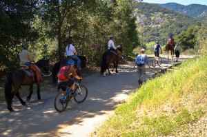
It is within CORBA’s mission to help protect and preserve our open spaces and public lands, in addition to providing access to those public lands through natural-surface, shared use trails. None of the alternatives presented in this newsletter outline any specific actions with regards to the Rim of the Valley Trail, but rather, provide an outline for the role the National Park Service might play in its future development and management.

We’ll look over these alternatives and publish our comments, and strongly encourage others to also comment by the January 7 deadline.

Below the break is the meeting schedule and offical notice for the study, which can be downloaded here.

——————————————————————————————————————

Preliminary Findings & Alternative Concepts Newsletter Available for

Rim of the Valley Corridor Special Resource Study

Dear Friends,

We are happy to report our progress on the Rim of the Valley Corridor Special Resource Study, and we invite your feedback on the preliminary ideas which are presented in our recently published Newsletter #3. The newsletter includes preliminary study findings that address whether resources of the study area are nationally significant, and whether they are suitable and feasible for inclusion in the national park system as a new park unit or as an addition to Santa Monica Mountains National Recreation Area (SMMNRA). Based on these preliminary findings, four preliminary alternative concepts are also presented in the newsletter for your consideration. Please send us your comments by January 7, 2013. 

The four preliminary alternative concepts presented in the newsletter illustrate different ways of providing protection and public enjoyment of resources that have been identified as potentiallynationally significant.  They include different levels and types of involvement by the National Park Service (NPS). Most importantly, these preliminary alternative concepts serve as a starting point for discussion and public input.

Please tell us what you think about the alternative concepts. Do you like one particular concept more than the others? Do you like various elements of each of the concepts? Do you have an entirely different vision of how the area should be managed? Your comments will help us refine the concepts and will ultimately lead to a recommendation to Congress.

We have scheduled seven public meetings extending through the month of November, concluding with a final meeting in early December. During these meetings, we will update you on our progress on the Rim of the Valley Corridor Special Resource Study and listen to your thoughts and ideas. Dates, times and locations of these meetings are listed below.  The NPS will also host a virtual public meeting online. Information on the virtual public meeting will be posted on the study website.

We look forward to hearing from you!


Wednesday, November 7, 7 – 9 p.m.
Conejo Recreation and Parks District, Community Room
403 W. Hillcrest Dr., Thousand Oaks,CA 91360

Thursday, November 8, 7 – 9 p.m.
George A. Caravalho Santa Clarita Sports Complex, Activities Center Building
20880 Centre Point Parkway
Santa Clarita, CA 91350

Tuesday, November 13, 6:30 – 8:30 p.m.***
Pacific Community Center
501 S. Pacific Ave.
Glendale, CA 91204

Thursday, November 15, 7 – 9 p.m.
Mason Recreation Center
10500 Mason Ave.
Chatsworth, CA 91311

Tuesday, November 27, 6:30 – 8:30 p.m.
Encino Community Center Women’s Club
4935 Balboa Blvd.
Encino, CA 91316

Thursday, November 29, 7 – 9 p.m.***
Moorpark Community Center
799 Moorpark Ave.
Moorpark, CA 93021

Saturday, December 1, 10 a.m. – noon
Eaton Canyon Nature Center
1750 North Altadena Dr.
Pasadena, CA 91107

CORBA Presentation for Land Managers, October 19, 2012

Monday, October 1st, 2012

CORBA and our neighboring IMBA chapter, the Mount Wilson Bicycling Association, will be co-hosting the IMBA Trail Care Crew for a visit to our local mountains. As a part of their visit, we are together hosting a session for Land Managers. The session will introduce you to IMBA as an organization. Attendees will learn how we, as local IMBA Chapters, can help land managers with their trails and open space programs, as well as up-to-date techniques and principles of trail design and construction. Additionally the Trail Care Crew will teach a one-day trailbuilding and maintenance class for volunteers.

The IMBA Trail Care Crew is world-renowned for their expertise in trail design, maintenance, and other issues. This is a unique opportunity to learn from those who live, breathe, and eat multi-use trails year-round, and to exchange ideas about trail construction, conflict resolution and other issues shared by most land managers.

The session is being held at the Angeles National Forest headquarters.

From the IMBA web site: “The Land Manager training educates land managers on IMBA and the practice of designing, building and maintaining sustainable trails; as well as the importance of partnerships with local mountain biking organizations to achieve great trails. The curriculum is geared toward land managers who oversee land that is either provides, or has the potential to provide mountain biking opportunities. This presentation is essential to inform land managers and community leaders on how to partner with clubs to build responsible, thoughtful trails. This presentation helps grow local group’s trust in IMBA, trail building and mountain biking.”

Besides the United States Forest Service, California State Parks, and Los Angeles County Parks and Recreation, we cordially invite all local government agencies and trail advocacy organizations in our area. The session size is limited to 30 people.

Please RSVP or email any questions to steve at corbamtb.com, or call 323-743-3682. 

IMBA Trail Care Crew with CORBA and MWBA
Land Managers’ Workshop
Friday, October 19, 2012, 1pm – 4pm.
Angeles National Forest Headquarters
701 N. Santa Anita Ave,
Arcadia, CA 91006

Directions: Google Map. If you are on the 210 freeway heading east, exit Santa Anita Avenue, and turn right at the off-ramp. Then turn immediately right into the ANF Headquarters, just a few yards south of the off-ramp. From the 210 west, turn left, proceed under the freeeway, and look for the first driveway after passing the eastbound freeway off ramp.

Placerita Canyon, Vasquez Rocks Trails Public Meeting Announced for July 12

Wednesday, June 20th, 2012

LA County Public MeetingThe County of Los Angeles has completed their assessment of trails in Placerita Canyon Natural Area, and Vasquez Rocks.  They have scheduled a meeting to discuss their findings and draft report for:


July 12, 2012, 6 p.m. 

William S. Hart Park – Hart Hall

24151 N. Newhall Avenue, Newhall, Ca 91321

The Canyon Trail was closed to mountain bikes, after having been posted open for several years, in 2011. Mountain bikers came out en masse at the initial public meeting, and we hope for a similar turnout at this next meeting. Los Angeles County has applied the State Parks Change-in-use Assessment tool to evaluate the trails, and will make recommendations based on their objective findings. The State has been actively developing and testing the tool over the past two years. It’s initial test in Southern California was on the Tapia Spur trail. In that case it was found that with some modifications, the trail could be made safe and sustainable for all users, including mountain bikes. Tapia Spur is currently in the process of being upgraded with those recommended modifications. We would hope for a similar outcome in the County’s application of the tool.

The draft report itself will be released on June 28, twelve days before the public meeting.  We will post a notice and a quick review of the report once it is made publicly available.