Archive for the ‘Angeles National Forest’ Category

Rim of the Valley Study Comments

Friday, October 29th, 2010

As we reported back in August, the National Park Service has been holding public hearings on the Rim of the Valley Special Resource Study.  The public meetings have provided an opportunity for many to voice their support and/or concerns for the concept study.  Until midnight tonight, you can email your comments to the National Park Service.

Rim of the Valley Study Area Map

Rim of the Valley Study Area

The Rim of the Valley is comprised of the open spaces that surround the San Fernando, La Crescenta, Santa Clarita, Simi and Conejo valleys. This area spans both Los Angeles and Ventury County, and a bevy of land managers from different agencies. CORBA fully supports the prospect of having these various land managers come together under the direction of the National Park Service, with the goal of permanently protecting this vital ecological and recreational resource.

(more…)

Pinecrest Gate to the Mt. Wilson Toll Road

Friday, October 29th, 2010

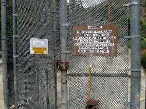
For those of us who ride the Mount Wilson toll road, we’ve all faced the prospect of racing to beat the closure of the gate at Pinecrest Avenue at dusk.

Unofficial-looking, hand-made signs on the Pinecrest GateMountain bikers are not the only ones affected by this troublesome and potentially hazardous gate. Hikers, equestrians and dog walkers also face the prospect of being trapped behind the gate after dark.

For cyclists, this is especially troublesome as there is no alternative legal place for cyclists to exit without backtracking up the Mt. Wilson Toll road or Altadena Crest Trail to an alternate trailhead. Bicycles are prohibited in Eaton Canyon, which is in itself a hazardous journey after dark for all trail users.

The Altadena Crest Trail Restoration Working Group has recently made their feelings on this foreboding gate known to the Mayor of Pasadena and other key government officials. CORBA fully supports their position, demanding that the gate be removed or replaced. Our official letter to the Mayor of Pasadena and other officials is below and continues after the break.

We encourage all concerned trail users to write to the Pasadena’s Mayor and City Council to express your feelings about the Pinecrest Gate situation.

The Pinecrest Gate, as seen on Google Street View. The now-repaired landslide is visible if you rotate the image to the right:


View Larger Map

A PDF copy of the letter is available for download, or read on below:

October 26, 2010

Hon. Bill Bogaard, Mayor
City of Pasadena
100 N. Garfield Avenue, Room S228
P.O. Box 7115
Pasadena, CA 91109-7215

Re: Pinecrest Gate at Eaton Canyon Park

Dear Mr. Mayor,

We urge you to remove or open the Pinecrest Gate to allow full 24/7 recreational access to the Altadena Crest Trail, the Mount Wilson Toll Road and Angeles National Forest.

As a non-profit serving and representing off-road cyclists from the greater Los Angeles region, CORBA has received numerous reports from our concerned members about the condition of the Pinecrest gate. The Pinecrest trailhead is a historically significant and popular access point to the Angeles National Forest for off-road cyclists, hikers and equestrians alike.

(more…)

El Prieto Trailwork Day – Nov 7

Tuesday, October 26th, 2010

Join CORBA, the Friends of El Prieto, the St. Francis High School MTB Team and others to help restore this favorite trail in the Angeles front country.

We will meet at 7:45 so we can head out by about 8:00 a.m. Join us to do brush removal and trail repair on one of So Cal Mountain Bikers’ favorite trails.

The trail repair work may involve some heavy lifting, rock-reinforcing some sections and rebuilding sections of trail. We’ll also be clearing brush from much of the trail, which has grown back since the Station fire. We need to prepare the trail for the coming winter and to keep it in good shape for when this part of the forest eventually opens (Note that it is still closed, and we will be working in the area with Forest Service permission).

Flat Attack Tire Sealant

This trailwork day is being sponsored by Flat Attack. The first 20 people to RSVP at http://membership.corbamtb.com will get a bottle of this great flat-prevention product.  CORBA’s trail crew also receives generous support for REI.

No experience necessary. Tools and instruction will be supplied. Be prepared with long sleeves, long pants, sturdy hiking shoes and drinking water.

Please RSVP at http://membership.corbamtb.com.Flyer is available for you to download, print, and spread the word. Rain cancels.

If you can’t make November 7th, but still want to help, there is another opportunity this weekend. 8 a.m. on October 30th, Conor Uhlir will be restoring the picnic table area along the El Prieto trail as part of his Eagle Scout project. Download the PDF flyer for his trailwork day here.

Station Fire Closure Order Extended

Saturday, September 25th, 2010

Last week the Forest Service issued an updated closure order for the Station Fire burn areas of the Angeles National Forest. The closure order has been extended until 9/19/2011. Part of the Forest has been opened. Unfortunately, the newly re-opened section of the forest is limited to a small portion in the Sunland area. This is much less than most had hoped for, but includes areas around the Doc Larsen trail which CORBA trail crews worked on back in June and July.

Here is the official press release from the Forest Service:

Date: Sept. 17, 2010
ANF Release # 10-12

FOR IMMEDIATE RELEASE

Angeles National Forest
701 N. Santa Anita Avenue
Arcadia, CA 91006

www.fs.fed.us/r5/angeles

Contact: Sherry Rollman or
John D. Wagner at (626) 574-5208

Angeles National Forest reopens areas offering hiking, picnicking

ARCADIA, Calif.–Angeles National Forest will reopen an area about five miles long and two miles wide, northwest of Sunland, closed since the Station Fire last year.

The reopening of the Little Tujunga-Riverwood area is set for Monday (Sept. 20) and will offer the public recreation including picnicking and hiking. The area is being opened after trail improvements and storm-debris removal were completed.

The bulk of the forest’s burned areas remain closed for public safety, until further notice. “The Forest Service intent is to reopen areas severely damaged in the fire over the next few years as conditions allow,” said Jody Noiron, forest supervisor.

“We are developing a cohesive plan to create healthier, more sustainable ecosystems, involving water, vegetation and wildlife,” Noiron said. “We are making the hard decisions toward a healthier open-space for the L.A. basin in the future.”

Reopenings are taking place through a restoration plan, which engages the public on improving the health of the San Gabriel Mountains, and enlists volunteers.

The Forest Service invites volunteers, partners and others to help the forest with its natural resource conservation needs. If individuals or groups are interested in joining the efforts please visit our website at http://www.fs.fed.us/r5/angeles/.

The forest order for the pending reopening and an official map can also be viewed on the website.

Order No. 01-10-05
AREA CLOSURE
ANGELES NATIONAL FOREST
Pursuant to 16 USC 551 and 36 CFR 261.50(a) and (b), and to protect natural resources and provide for public
safety, the following acts are prohibited within the Station Fire Recovery Area of the Angeles National Forest. This
Order is effective from September 20, 2010, through September 19, 2011.
1. Going into or being upon National Forest System lands within the Station Fire Recovery Area, except
the Hidden Springs Day Use Area and Monte Cristo Campground. The Station Fire Recovery Area is
described in Exhibit A and shown on Exhibit B. 36 CFR 261.53(e).
2. Being on any National Forest System road within the Station Fire Recovery Area, which is described in
Exhibit A and shown on Exhibit B. 36 CFR 261.54(e).
3. Being on any National Forest System trail within the Station Fire Recovery Area, which is described in
Exhibit A and shown on Exhibit B. 36 CFR 261.55(a).
Pursuant to 36 CFR 261.50(e), the following persons are exempt from this Order:
1. Persons with a permit from the Forest Service specifically authorizing the otherwise prohibited act or
omission.
2. Owners or lessees of private land within the Station Fire Recovery Area are exempt from the prohibitions
listed above to the extent necessary to gain access to their land.
3. Persons who reside on private land within the Station Fire Recovery Area are exempt from the prohibitions
listed above to the extent necessary to gain access to their residences.
4. Persons with a special use permit or contract from the Forest Service authorizing work within the Station
Fire Recovery Area and their employees, sub-contractors, or agents are exempt from the prohibitions listed
above to the extent authorized by the special use permit or contract.
5. Any Federal, State, or local officer, or member of an organized rescue or fire fighting force in the
performance of an official duty.

Rim of the Valley Corridor Public Meetings – Mountain Bikers Needed!

Tuesday, August 24th, 2010

Rim of the Valley Study Area

Rim of the Valley Study Area

The National Park Service is in the initial stages of conducting a “special resource study” of the area known as the “Rim of the Valley Corridor.” This is the area that generally includes the mountains encircling the San Fernando, La Crescenta, Santa Clarita, Simi and Conejo Valleys of Los Angeles and Ventura Counties in southern California.

On May 7 2008, P.L. 110-229, the Consolidated Natural Resources Act of 2008 received final approval. Within that legislation the Secretary of the Interior is authorized to complete a special resource study of the Rim of the Valley Corridor. Specifically, this is a study to determine how to manage this special resource for environmental and recreational purposes.

It is vitally important that mountain bikers are represented at these public hearings to ensure that we are included in the planning process. There are some individuals and groups who would rather see mountain bikers banned from trails in the study areas. We want to ensure multi-use designations throughout the trail systems. The study corridor covers numerous land managers’ and agencies’ jurisdictions, complicating the process. We want to ensure access and trail connectivity for mountain bikers throughout the corridor.

Visit http://www.nps.gov/pwro/rimofthevalley/ to learn more.

Meetings are scheduled:

Tuesday, September 14, 2010, 7-9 p.m.

Mason Recreation Center

10500 Mason Ave.

Chatsworth, CA 91311

Wednesday, September 15, 2010***

2-4 p.m. and 6:30-8:30 p.m.

Los Angeles River Center and Gardens

570 W. Avenue 26

Los Angeles, CA 90065

Tuesday, September 21, 2010, 7-9 p.m.

George A. Caravalho Santa Clarita Sports Complex-Activities Center Building

20880 Centre Pointe Parkway

Santa Clarita, CA 91350

Wednesday, September 22, 2010, 7-9 p.m.

Conejo Recreation and Parks District

Community Room

403 W. Hillcrest Dr.

Thousand Oaks, CA 91360

Monday, October 4, 2010, 7-9 p.m.

King Gillette Ranch

26800 West Mulholland Highway

Calabasas, CA 91302

Tuesday, October 5, 2010, 7-9 p.m.***

Northeast Valley City Hall

7747 Foothill Blvd.

Tujunga, CA 91042

Wednesday, October 6, 2010, 7-9 p.m.

Charles S. Farnsworth Park

Davies Building

568 East Mount Curve Ave.

Altadena, CA 91001

$700,000 sought to fix trails, roads destroyed in Station fire

Wednesday, August 4th, 2010

From the Glendale News-Press and the LA Times 

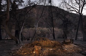
An incinerated car sits in the devastated hamlet of Vogel Flats, which is along Big Tujunga Canyon Road in the Angeles National Forest, in September of 2009 . Credit: Luis Sinco / Los Angeles Times

Roughly $700,000 has been earmarked for improving the forest roads and trails that were destroyed last year during the Station fire, officials said. 

Rep. Adam Schiff (D-Burbank) secured the earmark in the Interior Appropriations bill for restoring the 160,577 acres of scorched landscape that’s in severe need of restoration. 

“The roads and trails have been eroded and degraded,” said Richard Toyon, former forest ranger and president of the local nonprofit Volunteers Organizing in Conserving the Environment. 

Trekking on some trails in the forest is challenging because they eventually disappear, he said, and some roads and trails are no longer recognizable. 

The bill must still pass the full House and Senate before reaching President Obama’s desk, said Schiff’s spokeswoman, Maureen Shanahan. 

If the bill is approved, the funding would be allocated to the U.S. Forest Service to handle the restoration work. 

“This funding will help repair the roads and trails that were damaged in the fire to restore safety and access for families to enjoy one of California’s greatest natural resources,” Schiff said in a statement. 

Engineers for the Angeles National Forest have estimated that about 300 miles of roads and 225 miles of trails were harmed during the Station fire, according to Schiff’s office. 

Damage to roads and trails worsened due to erosion and landslides during the winter. 

Gov. Arnold Schwarzenegger on Feb. 11 declared the footprint of the fire a disaster area. 

Some of the roads have been closed due to the extensive damage, and trails that have been deemed unsafe for hiking have been off limits. 

Officials are planning to focus the funding on the most critically damaged roads with the largest access points. 

Some road improvements include installing retaining walls, reconstructing low water crossings, grading surfaces, repairing drainage, repaving and restoring signage, according to Schiff’s office. 

Trail improvements include drainage repairs, re-stabilizing slopes and restoring walking surfaces. 


Angeles Crest Highway closures cause confusion and frustration

Wednesday, July 28th, 2010

From the Los Angeles Times  

Hundreds of hikers and bicyclists have been spotted in areas closed for construction. Some are genuinely unaware of the roadblocks along the popular trails, while others trespass out of defiance.  

With a small day pack strapped to his back, Scott Groves set out from his home in Pasadena to the foot of the Mt. Wilson Trail in Sierra Madre. He climbed seven miles to the top of the mountain and then proceeded down Mt. Wilson Road before happening upon the closed portion of Angeles Crest Highway.  

About 20 miles of the 66-mile Angeles Crest Highway is closed for construction. The $16.5 million in road repairs is expected to be completed in November. (Raul Roa, La Canada / July 6, 2010)

“It wasn’t even on my radar that this was closed,” Groves said as he stopped to fill his water pouch near the intersection of Angeles Crest and Angeles Forest highways. “I had read that it was clear to come up from the Palmdale side, so I figured everything here was cool.” 

About 20 miles of the 66-mile Angeles Crest Highway, from La Cañada Flintridge to Mt. Wilson Road and 25% of the Angeles National Forest remain off-limits to the public as construction crews rebuild pieces of the route that winter storms caused to wash out. The $16.5 million in repairs, contracted out to Thousand Oaks-based Burns Pacific Construction, is expected to be completed in November.  

Meanwhile, the closures continue to frustrate and confuse those seeking to access some of the most popular portions of the San Gabriel Mountains. Hundreds of motorcyclists, bicyclists and hikers have been spotted in restricted areas, according to officials from the California Department of Transportation and U.S. Forest Service. Some of the trespassing seems to be due to genuine misunderstanding about the status of different portions of the road and forest.  

In late June, Caltrans Public Information Officer Patrick Chandler intercepted a dozen members of a family setting off on a hike.  

“They parked at Angeles Forest Highway where it meets Angeles Crest and walked up to the closure and were going to go down to Switzer Falls,” Chandler said.  

He had to explain to the family that the popular trail was closed. But hikers have not been alone in their confusion: Road repair workers reported that Los Angeles County public safety personnel have attempted to respond to emergency calls by traveling north on Angeles Crest Highway, only to hit roadblocks.  

Los Angeles County Fire Battalion Chief Mitch Brookhyser confirmed one such incident. On May 31, units from La Cañada Flintridge’s Station No. 82 responded to a call of a motorcycle that had gone off the side of Angeles Crest, Brookhyser said. The responders were forced to stop at a locked gate. The call was canceled minutes later, he said.  

Many of those entering closed portions of the highway and forest, however, are doing so with overt disregard for clearly posted signs, Chandler said. A Las Vegas motorcycle crew posted on its blog a dozen photos of members circumventing closures and being cited by the California Highway Patrol during an outing in May.  

And on a recent afternoon, Jim Blake, a Lake View Terrace resident and avid bicyclist, stopped to watch workers repair a 200-foot-deep washout near Brown Canyon — the largest of the two dozen damaged spots. He had pedaled 27 miles, traveling on Big Tujunga Canyon Road, Angeles Forest Highway and Angeles Crest Highway.  

“Big Tujunga Canyon was open,” Blake said. “Then they had some signs on Angeles Forest Highway that it was closed ahead, but cars could go through. At Angeles Crest Highway they had a gate, but I could get through there.”  

He enjoyed having the road to himself, Blake said, although he did have to steer clear of a couple of dump trucks.

Trailwork Days: Doc Larson Trail June 26, July 10

Monday, June 21st, 2010

CORBA will be assisting Chris Sercel with his Eagle Scout project to restore the Upper Doc Larson trail in the Sunland area of the Angeles National Forest. Doc Larson trail is a multi-use singletrack. We’ll be working on the upper section, and a singletrack connector trail that ties it into a loop with the surrounding fire roads. Meet in Lake View Terrace at the address above and either carpool or ride to the trailhead.  Meet at 7:30 at the address listed on the CORBA trailwork calendar, and we’ll carpool or ride up from there. Be sure to bring sturdy shoes, long pants and long sleeve shirts. We’ll be doing brushwork and some treadwork. This area is still within the Station Fire closure area, so we’ll be working with special permission from the Forest Service. A second day of work will happen on July 10th to complete the project. Lunch will be provided so please RSVP to csizzles99@gmail.com and/or to trailcrew@corbamtb.com, or on the CORBA Google Calendar if you have a google account.

Angeles National Forest Recovery Plans

Tuesday, June 1st, 2010

There was an informational meeting on the recovery plans for the Angeles National Forest May 26, 2010 at the Eaton Canyon Nature Center.  Representatives from the U.S. Forest Service, San Gabriel Mountains Trailbuilders, the Sierra Club, TreePeople, Student Conservation Association, Caltrans, and Outward Bound were present.

The intent of the Recovery Plan is to create a more ecologically sustainable forest than before and to build a community of involved users.

There was a brief mention of San Gabriel Mountains Forever, a group the Sierra Club supports and that has the goals of promoting the proposed San Gabriel National Recreation Area and of increasing wilderness in the San Gabriels.  CORBA is investigating this wilderness proposal and its potential impact on multi-use trails.

An intern from Congressman Schiff’s office announced an upcoming informational meeting on the Rim of the Valley Corridor Special Resource Study.  The Corridor is a Santa Monica Mountains Conservancy project to expand the National Recreation Area. The meeting will be at the Nature Center at 10 am, Friday, June 4.

Mike MacIntyre, the River District Ranger for the Angeles National Forest discussed the new closure order.  Details of that are on the ANF web site.  He showed some photos of the extensive damage to the upper Arroyo Seco, Gould Mesa Road, several fire stations, Grizzly Flats Road, and Vogel Flats area.  He reported that a large boulder had been blasted from the Mt. Wilson Toll  Road near Mt. Harvard. He also confirmed that Millard campground is open, but not El Prieto, Sunset Ridge or other trails.  They are looking to open more areas by the July 4th weekend.

He noted about 35,000 acres of forested land burned, 24,000 of that was pretty much denuded and may not come back on its own.  There are plans to reforest about 11,000 acres of the 24,000.  Seedlings were not available to get started this year, and planting is expected to start with an initial 4400 acres in early 2011.  Carbon credits, grants, and Congressional sources will fund the project.<

A representative from the Tree People explained that there is a narrow window for replanting because the soil has to warm and be moist. If they wait too long it is too hot and dry for the seedlings to survive without watering, which is usually not practical.  They are recruiting and training for 2011 now.  Tree People are the lead group on the reforestation efforts.

Bob Cates reported that the Sierra Club’s Angeles Forest Restoration Project will be working on trails the 2nd and 4th Saturday of every month starting in July. They have 380 volunteers signed up. They focus on the area up Highway 39 to Crystal Lake.

The Student Conservation Association is 50+ years old, but until 2004 did not have a presence in SoCal.  They have both paid workers and non-paid volunteers. Besides doing all kinds of conservation related work, they encourage participants to consider careers in forestry, wildlife management, conservation, etc.  They have some crews working with the USFS on the fire recovery.  These crews work for several weeks at a time, so can get into back country and handle more complex jobs.

The final speaker was Patrick Chandler from Caltrans District 7.  There were 25 washouts or slides along the closed section of Highway 2.  Caltrans are hoping to have it open by mid-July.  Most of the problem was that the debris flows blocked all the drains, then the water washed across the road and off the down side eroding the shoulders and below and undermining the roadbeds. Although the engineers wanted to, they are not going to build any bridges, as there are no funds available.

Thanks to CORBA member Mitch Marich for the report.

ANF Opens Campgrounds, But Few Trails

Wednesday, May 26th, 2010

The Angeles National Forest issued a revised Closure order this week, just in time for Memorial Day weekend. While very little has been opened, campgrounds such as Horse Flats, Chilao and Millard are now open for camping.

But don’t get too excited. None of the trails around Millard (Sunset Ridge, Dawn Mine, El Prieto) are open. Work on the restoration of Sunset Ridge continues, and El Prieto has had extensive restoration work done, though according to FS officials neither are ready or safe enough for general use. Fire roads in the area are also extensively damaged.

In the Chilao area, sections of the Silver Mocassin trail are unburned and will probably be open, but the traditional figure-eight loop we all love is not possible, as the Vetter Trail and other sections of the Silver Mocassin and Hillyer trail are impassable and most likely in the closed area.

A map of the new closure order area is posted on the FS web site, though the resolution is not high enough to definitively determine which trails are officially open. They expect to have a higher resolution map available soon. In the meantime, obey all trail closure signs and be safe if you’re heading up there.

If you plan to visit the area, also remember that the Angeles Crest Highway between La Canada and Red Box remains closed. Caltrans has revised it’s projected completion of repairs, and we may see this section of highway open by the end of this summer. You need to access the Forest from Big Tujunga Canyon to Upper Big Tujunga Canyon, or via the Angeles Forest Highway to the north.