Archive for the ‘Trail Access’ Category

Opening of Pt Mugu State Park Delayed

Saturday, January 3rd, 2015
Mud has buried the main Sycamore Canyon Trail. Photo by Dave Edwards.

Mud and rocks have buried the main Sycamore Canyon Trail. Photo by Dave Edwards.

When we first posted this blog in mid-December, State Parks anticipated that they would have Pt Mugu State Park open around January 12th. However, Caltrans has determined that it will take at least until the end of January before the Pacific Coast Highway can be re-opened, so the park closure will be extended.

We’ll update this information when we have more to share.

The original article follows…

The rainstorm that swept through the area late last week resulted in several large mudslides in Point Mugu State Park (AKA Sycamore Canyon). As a result, the park has been closed at least until January 12th, 2015. During this time, State Parks staff will be assessing the damage, cleaning up the mess and coordinating volunteers to help with the cleanup.

The mudslides are the direct result of the hillsides being denuded by the Springs Fire in 2013 and over 3″ of rain that fell in one night.

More photos of the damage can be seen in this photo gallery.

You can find the status of the park at the Pt Mugu State Park website home page.

Please stay out of the park until it reopens, for your safety, to prevent further damage to the trails, and to enable a more speedy cleanup.

President’s Message: A Look Back at 2014

Tuesday, December 30th, 2014

As we prepare to ring in the new year, it’s a good time to reflect on what has happened over the past twelve months. Here’s a quick recap of CORBA’s most significant efforts of 2014.

strawberry peak trail crew Volunteers, February 16, 2014

Volunteers, February 16, 2014

Trailwork:  One of our biggest accomplishments in 2014 was the restoration of the Strawberry Peak Loop in spring, and the subsequent opening of the trail by the Forest Service on May 28. This much-loved trail was the focus of CORBA, The Sierra Club, and the Los Angeles Conservation Corps as we coordinated efforts to get the trail ready for opening. We were aided by a grant from REI which allowed us to bring in a professional trailbuilder for much of the heavier work. The restoration included a short re-route of one section of the trail that had always been troublesome.  Another planned re-route of the northern end of the Strawberry Peak trail through to Colby ranch is currently in the NEPA process, but the main Strawberry Peak loop used by cyclists is open and has been enjoyed all summer and fall. We also helped restore trails damaged in the Springs fire in Point Mugu State Park, worked on the Backbone trail, and our adopted Los Robles trail. For 2015 we are enlisting some new trail crew leaders, as we look to expand our trailwork activities.


CORBA's Youth Adventures

CORBA’s Youth Adventures

Youth Programs:  In 2014 our Youth Adventures program continued in full swing, with Mountain Bike Unit (MBU) volunteers taking at-risk youth out on the trails throughout the year.  We added another special event to our calendar, the Santa Monica Mountains Rec Fest, during which we put more than 200 kids on bikes at Paramount Ranch in the Santa Monica Mountains. The Rec Fest was a great addition to the calendar, and we are hoping that funding can be found to repeat the event. In 2014 our Kids Club program was picked up by Carl Kolvenbach who is leading these monthly social rides for kids and their parents.


Skills Clinics: For the first Saturday of every month this year, and the past twenty years, we conducted our free Introduction to Mountain Biking Skills Clinics at Malibu Creek State Park. Hundreds of people learned basic skills at our free clinics this year. This free service will continue through 2015 and beyond.


Fillmore Bike Park Jump Line

Fillmore Bike Park Jump Line

Bike Parks:  Fillmore Bike Park construction is well underway. We worked with local advocates from Ride Heritage Valley and the City of Fillmore to bring a new bike park to the town. Construction began in the fall and is ongoing. The park will be opened to the public in 2015, a great asset to the local community.  In Thousand Oaks the plans for Sapwi Trails Community Park are in their final steps to approval. The plans include a pump track and dirt jumps for bikes, along with multi-use trails. We’re excited to see this facility approved and look forward to its construction. We still have pending proposals before L.A. County, and we hope to see continued progress on those proposals in the new year.


National Forest Management Plans:  2014 also saw the completion of the four SoCal National Forests Land Management Plan Amendments. During this five-year process we engaged with the Forest Service on the re-examination of their land management plans. The Forest Service was sued for not providing adequate protections for threatened and endangered species, and the settlement agreement had the Forest Service reassess areas of the four Forests for increased protections. The outcome of that process was the proposed Fish Canyon Recommended Wilderness. We filed a formal objection to the RW, as it would close three long-distance backcountry trails to bikes. Though these were not popular trails and hardly saw any use over the past several years, they are still a loss of opportunity to the mountain biking community. The final record of decision was a happy compromise: We now have a recommended wilderness area, but the trails will remain open to bikes until such time as a forest order is issued to specifically close the trails to bicycles.

President Obama signs the proclamation of the San Gabriel Mountains National Monument

President Obama signs the proclamation

National Monument: One of the biggest surprises of the year was the announcement and soon thereafter, the proclamation of the new San Gabriel Mountains National Monument. While we were all taken by surprise with this announcement, the outcome, our new National Monument, will help the Forest Service attract more resources to the area and bring more attention to our beloved mountains. CORBA will be actively participating in the development of the Management Plan for the National Monument, both as a part of the NEPA process, and as a part of a collaborative group brought together by the National Forest Foundation to ensure as much public engagement as possible in that process.


Bell boxes contain bells   which are free to all users. Please use a bell!

Bell boxes contain bells which are free to all users. Please use a bell!

Trail Safety: Over this past year CORBA engaged with the Santa Monica Mountains Trails Council to strategize on trail safety. We developed an educational trail etiquette brochure, which is now being distributed throughout the area. The brochure has been very well-received. In 2015 we will expand upon those efforts by developing a companion trail etiquette web site. We have received a grant from the Trails and Greenways Foundation to achieve this goal. CORBA has also implemented a bell program in the Conejo Valley, and we now have several different style bells available for purchase.


CORBA Board: In 2014 we welcomed Wendy Engelberg to our board of directors, and the bundle of energy and enthusiasm she brings. Steve Messer took over from Mark Langton as board President, while Jennifer Klausner completed her final year as Executive Director of the LA County Bicycle Coalition. We have open seats on our board and welcome any inquiries or nominations.


A few losses: We lost our battle with State Parks over the revision of the California Code of Regulations pertaining to trail use in State Parks. While a win would have changed nothing with regards to existing trails, we felt the language we proposed was more welcoming to all trail users and a better regulation for new trails. State Parks leadership were chided for a mismanaged public process in developing the new regulations, which have since been sent back into the public process. However, it has become obvious that no amount of public engagement is going to change what State Parks wanted in the first place, a regulation that makes it more difficult to open trails to bikes.

California State Parks have been under much scrutiny with the Parks Forward Commission releasing findings of numerous areas that need improvement in the administration of our State Parks. Their plan will be released sometime in 2015. We are hoping to see some of the recommendations of the commission implemented, but the reforms will likely be difficult in this chronically mismanaged agency.

Looking forward to 2015, we’ll be as busy as ever. We’ll continue to work with State Parks, the National Park Service, the Forest Service, Los Angeles County, Mountains Recreation and Conservation Authority, Conejo Open Space Conservation Agency and local cities and conservancies. We’ll continue to monitor trail access issues. We’ll continue to advocate for more trail opportunities. We’ll continue to work with IMBA at the national level, and our neighboring IMBA Chapters and other trail organizations locally and state-wide.

At the moment we know of at least three major issues that will get our full attention in 2015. The first is the previously mentioned San Gabriel Mountains National Monument Management Plan.

Next is the Santa Monica Mountain Trails Master Plan. This plan has been in development for more than 12 years, and is the primary reason that State Parks have not yet followed through on their obligation to assess existing trails for bicycle use. We expect public hearings on the trail master plan to begin mid-winter. This will be one of the most important processes for you to stay involved with, and will determine the future of bicycle access to trails in the Santa Monica Mountains for decades to come.

Rim of the Valley Study Area

Rim of the Valley Study Area

The Rim of the Valley Corridor Study will also be released in Winter 2015. This study is examining the mountains surrounding the San Fernando, Simi, Conejo, and Crescenta and San Rafael valleys for an integrated management approach. This study has implications for trail connectivity, resource protection, wildlife corridors and more.

We need your support. CORBA, with it’s small but dedicated crew of volunteers, has a lot on our plate for 2015. But if we are to accomplish everything on our agenda for 2015, we’ll need some help from you. We depend on your support and your membership dollars. You have renewed your membership, right?  In addition to your membership, attending public meetings and submitting your comments on issues that affect our trails is the most important thing you can do.  Of course, volunteering to do trailwork is the most tangible ways you can make a difference. Join our Meetup group to stay up to date on our activities. We also welcome help in areas of graphic design, public relations/marketing, fundraising and grantwriting. If you’d like to just stay on top of what’s happening and get some of the inside scoop, consider attending our monthly board meetings.

Get out and ride. Stay informed and involved. Remember to be courteous to other trail users. Thanks for your support through a great 2014, and have a wonderful, happy and prosperous 2015!

West End of Etz Meloy Gets Another Gate

Friday, October 31st, 2014

IMG_2132CORBA was alerted to the fact that a private property owner at the west end of Etz Meloy Motorway (a section of the Backbone Trail) at Yerba Buena Road has erected a second, new gate to deter the public from using the route. From the National Park Service:
The 1-mile stretch of Etz Meloy Mtwy. heading east from Yerba Buena Rd. is not open to the public.  The stretch of Etz Meloy Mtwy. across this area is not to be used by trail visitors. By using it, visitors will only aggravate the situation.

CORBA reminds everyone to respect private property and not go over/around the gate as this action is not only illegal, it can also jeopardize negotiations with the landowners and NPS moving toward some kind of easement agreement.

An earlier blog has more details, history and several comments on the gate that prevents access to the Etz Meloy Mtwy from the west end.

BBT_EtzMeloyGap_Nov17_2011

Sequioa, Inyo and Sierra Forest Plans Hinder Sharing the PCT Campaign

Thursday, October 2nd, 2014


Access to many trails could be affected by new Wilderness

Access to many trails could be affected by new Wilderness

The three major National Forests of the Southern Sierras are currently in the process of updating their Forest Management Plans. They are developing their plans under the guidelines of the new 2012 planning process. As they are among the first forests to do so, they are being referred to as “early-adopters” of the new planning process.

Part of the 2012 planning process requires the forests to evaluate areas of the forest they may be suitable for addition into the Wilderness Protection System. Currently, a large proportion of all three of these forests are designated Wilderness and are off-limits to bicycles. Many people heeding the environmentalists calls for wilderness at any cost, don’t realize that this greatly impacts recreational access. We are objecting to any new wilderness areas in these plans.

Another aspect of the plan calls for the designation of a Pacific Crest National Scenic Trail Corridor. The provisions prohibit any trail that allows bicycles or motorcycles to even CROSS the PCT, and gives the Pacific Crest Trail Association veto power over any trails that lie within that corridor, even if they are not the PCT. This is extremely troublesome, and may even be illegal.

As you may be aware, a group of people have been actively urging the forest service to review the order that closed the PCT to bicycles in 1988. The decision to close the PCT was never publicly reviewed, as required by the forest service own management guidelines and public law. Portions of this plan would circumvent that legally required public process, and making the ban on bicycles permanent. In the opinion of many, the current ban on bicycles was enacted in the same way a temporary order would be enacted, and is required to be reviewed regularly.

CORBA submitted the following comments on the plans, as this affects not only the PCT where it passes through the Sierras, but also has ramifications for our local portions of the PCT in the Angeles, San Bernardino and Cleveland National Forests. The comment period originally expired Monday, after only 30 days with a very poor public outreach effort. Comments are now being accepted an additional three days, ending tomorrow, October 3rd, 2014. Until then you still have a chance to submit comments here.

IMBA’s suggested talking points include:

  • The plan should include a trail planning Objective that will allow for a purposefully designed trail system, including bicycles.
  • Object to management that furthers the bicycle closure order on the Pacific Crest Trail.
  • Object to the delegation of any inherently governmental decision making authority to the Pacific Crest Trail Association.
  • Mountain bikers can be a huge asset to the PCT—we contribute 700,000 volunteer hours annually to trail stewardship.

For more information and suggestions on what to write in your comments, visit the following:


President’s Message: A National Monument?

Wednesday, September 3rd, 2014
Recently created Fort Ord National Monument ensures continued bicycle access

Recently created Fort Ord National Monument ensures continued bicycle access

Just two weeks ago the public learned of a movement to have the San Gabriel Mountains declared a National Monument. The news came as a surprise, and we had little time to look deeper into what this meant. Last week’s public meeting did serve one purpose well, to get the discussion–and the emotions–going. The sudden announcement caught everyone’s attention, all the way up to the Undersecretary for the Department of Agriculture. This meant that it was happening quickly, and the process was already underway. It’s in all our best interest to be a part of that process, whether or not the final outcome is a new National Monument.

Since last week’s public meeting, we’ve had time to begin a dialog with conservationists and other stakeholders and to do some research of our own. We now understand the Forest Service would continue to manage the land under a National Monument designation. We learned that recently declared For Ord National Monument has language specifically mentioning bicyclists as legitimate trail users, and directs that bicycles are accommodated in a transportation/trail plan. This is an extremely positive precedent which encourages us. We’ve had several verbal assurances that mountain biking access would not be impacted, and that similar language could be developed for this proposal.

As we begin to be involved in the development of that language, we are working with our fellow chapters, IMBA staff, and other stakeholders to ensure our continued ability to ride mountain bikes on the trails and fire roads we love, and to improve overall conditions in the forest (through better protections and additional funding). A well-written National Monument proclamation and any additional funding it brings may be preferable to the Angeles NF continuing to be underfunded and understaffed, or even a wilderness bill that would close off access to trails.

There are many competing interests for National Forest land. There are those interested in protecting it, developing it, and just recreating in it. The challenge will be to get the balance between those interests right. If a National Monument proclamation does move forward, as it appears to be, we need to be involved in its development and included in the outcome.

In the meantime remember to make time to ride. Every time we do so we remind ourselves why our local mountains are important to us. They’re important enough to protect, and important enough to want to ensure that our grandkids can enjoy similar trail experiences, and similar ways to connect with nature.

San Gabriel Mountains National Monument meeting, August 26th, 2014

Wednesday, August 27th, 2014

Supervisor Tom Contreras int
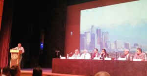
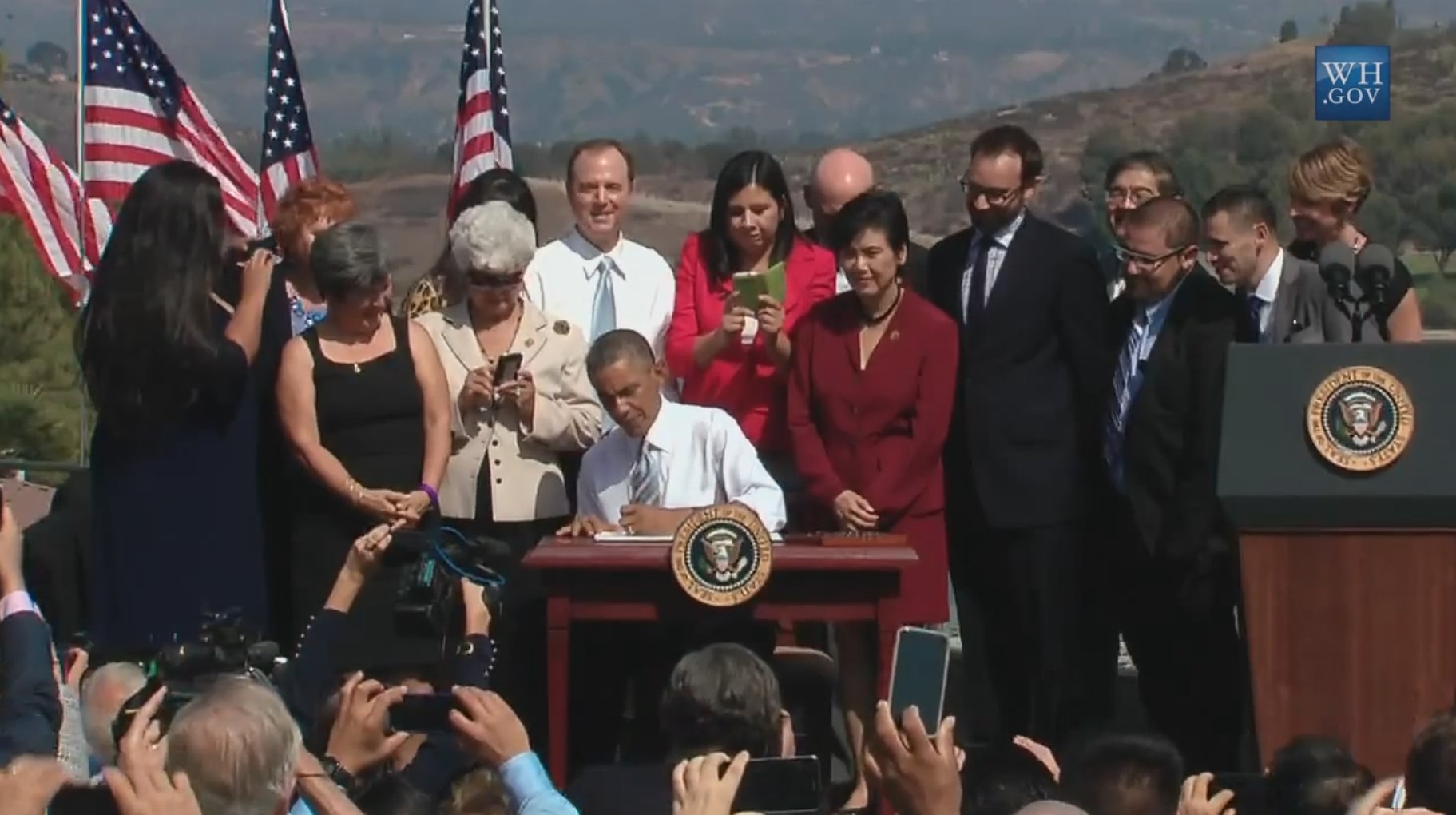
Last night an overflowing crowd packed into the Baldwin Park Performing Arts Center to hear from a panel of “experts” about the future of the San Gabriel Mountains. Among the honored guests and panel of experts were Robert Bonnie, the undersecretary for the Department of Agriculture, Tom Tidwell, Chief Forester of the Forest Service, Randy Moore, Regional Forester for the Southwest United States, and congressmen Judy Chu, Los Angeles County Supervisor-elect Hilda Solis, Janice Rutherford, San Bernardino Board of Supervisors Chairperson. Local politicians and wilderness advocates rounded out the panel, with Victor Diaz, chair of the Friends of the Angeles group, as the sole “user group” representative.

Also in the room were Tom Contreras, Supervisor of the Angeles National Forest, as well as Jody Noiron, Supervisor of the San Bernardino National Forest, and all of their respective district rangers. In fact there were more Forest Service staff and volunteers on hand than any event or public meeting I’ve ever had the privilege to attend.

The auditorium was packed to capacity, with over 200 people unable to enter the room because room capacity has been reached. The WIlderness Society and San Gabriel Mountains Forever group were offering free buses to the meeting, helping explain the huge turnout.

We learned from Tom Tidwell that a number of improvements will be happening in 2015, including new staff hires, new signage and other improvements to the forest. Trail Crews from the Los Angeles Conservation Corps and Urban Youth League are out continuing to restore and repair trails.

The panel were each asked a single orchestrated question by Oscar Gonzales, California State Executive Director of the Farm Services Agency, who also flew out from Washington DC. Their answers were well-orchestrated, mostly singing the potential praises of a National Monument. There were no specific plans or proposals revealed. Only Janice Rutherford from San Bernardino County asked the important questions: how will this be managed, what is the management plan, how will this be funded, how will economic development (for areas such as Wrightwood), recreation and conservation be balanced and impacted. Most importantly, why is this happening so suddenly with no outreach or input to her community?

I could ask the same… why no outreach to our community (of mountain bikers)?

In fact, for all the talk of how this process is starting, there was not even an opportunity to ask questions, and oversized postcards were the only means given to submit anonymous comments. There are no resources or commenting options available online.

After the meeting, in my conversations with the wilderness advocates, and with Tom TIdwell by Jenny from Mount Wilson Bicycling Association, we were given some verbal assurances: That the Forest Service would continue to manage the proposed National Monument, and that the intent is to continue to allow all forms of recreation currently allowed. These verbal assurances, while comforting, came with a caveat of “no guarantees.”

The stature of the dignitaries in town for this theater of support that there has to have been some very high-level discussions and planning going on behind the scenes. But for this meeting, the first real public outreach, nobody was able to refer to a specific plan, the language of the proclamation, nor discuss the ulterior motives of those behind the plan.

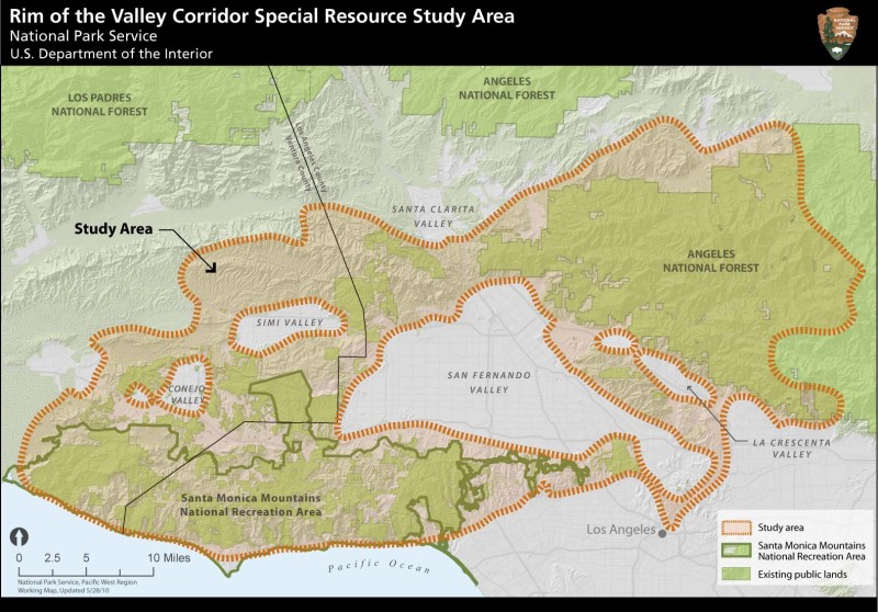
For that we need to dig a little further into the history of the efforts to “protect” the San Gabriel Mountains. In 2003 Hilda Solis and Barbara Boxer introduced the San Gabriel Watershed Study, to determine the area’s suitability for a National Recreation Area. Separately, The Congressionally authorized Rim of the Valley Study has been taking place over a similar time span. Most recently, the four Southern California National Forests were charged with re-assessing and amending their management plan, with a greater emphasis on protecting the landscape for threatened and endangered species habitat protection. We are still waiting on the final outcome of that land management plan amendment, but as of our last meetings, the Fish Canyon area north of Castaic was being proposed as a Recommended Wilderness. Additionally, David Drier introduced a wilderness bill in 2011, and Congressman Buck McKeon is currently considering another.

The San Gabriel Mountains Forever group, with close ties to the Wilderness Society and the Sierra Club, have been lobbying hard for additional resources and protection for the San Gabriel Mountains.

Congressman Judy Chu has introduced two bills, one to create a National Recreation Area, the other to declare many thousands of acres of new Wilderness, including Condor Peak, Fish Canyon, Red Mountain and other areas. The Forest Service’ own Land Management Plan amendments determined that Condor Peak and Red Mountain were a) not suitable for wilderness protection, and b) would be provided little if any additional “protection” by a Wilderness designation. We have to ask why does Chu’s bill ask for these additional wilderness areas that have been fought over and removed from previous wilderness legislation, and found unsuitable? Our official comments on that plan reflected this. Her National Recreation Area bill was similarly vague on specifics, and we thought, premature.

Frustration with the lack of congressional support for those bills is what supposedly drove Chu to petition the White House for a National Monument declaration, which bypasses congress and the debate and scrutiny it would receive there. The President, under the Antiquities Act, can declare a National Monument without the support of Congress.

At this time we simply do not have enough information to make an informed decision as to whether the National Monument is a good idea that will help Forest visitors, or one that will just add an additional layer of bureaucracy. The way some of the panel gushed about the plan, one could be led to believe that the declaration would instantly take care of overflowing trash, lack of bathrooms and facilities, trail maintenance, graffiti and other problems. But there has been no talk of how much, if any, additional funding this would bring, now how it will be managed and implemented.

We’d like to see the San Gabriel Mountains receive a new influx of funding and staff. We’d like to see better services and infrastructure needed to protect the mountains, and continue to allow us to recreate responsibly. A National Monument may in fact be the vehicle to get us there. We simply don’t have enough detailed information to make that decision.

We plan to meet with congress members whose districts include portions of the San Gabriel Mountains, as well as the conservationists that are lobbying hard for this. Until we have some face-to-face time with these people, and have answers to our questions, we must remain officially neutral, while at the same time being guardedly optimistic for the future of our beloved mountains.

Action Alert! Protect Mountain Bike Access

Saturday, August 16th, 2014

From our Friends to the north, Santa Clarita Valley Trail Users:

Dear Friends,

Congressman “Buck” McKeon is holding a Town Hall meeting to discuss a proposal to designate approximately 40,000 acres just north of Castaic Lake as a federally protected Wilderness area.  This proposed Wilderness area could potentially include the Fish Canyon, Salt Creek, Elderberry Canyon, Tule and Red Mountain areas on the northeast side of Castaic Lake.  All of these areas are very close to Tapia Canyon where the majority of mountain biking occurs in Santa Clarita AND which will likely be lost to development in the not too distant future.

Even though many of us would support the protection and preservation of our public lands, it is important to note that the Wilderness designation severely limits recreation on such lands.  Specifically, cycling or mountain biking is prohibited in Wilderness areas because they are “mechanized”.  Access is only allowed on foot or horseback.

Already, the federal government has set aside very large Wilderness areas near Santa Clarita including the Magic Mountain Wilderness (just south of the 14 Freeway near Canyon Country), the Sespe Wilderness (just north of Fillmore and Santa Paula), and the San Rafael Wilderness (just east of Ventura and Santa Barbara).  This is why you can’t ride a mountain bike in the mountains above Fillmore and why there are so few mountain bike trails in the Ventura/Santa Barbara area.  We think these three Wilderness areas near Santa Clarita are more than enough.

For this reason, we encourage you to attend next week’s Town Hall meeting to let Congressman McKeon know that you object to the Wilderness designation of these additional areas near Castaic Lake because it would permanently prohibit mountain biking.  The current designation of Backcountry – Non-motorized or something else more protective (such as a Special Conservation Area) would be preferred so long as mountain biking continues to be allowed.

Here are the details of the Town Hall meeting:

Date:  Tuesday, August 19

Time:  10:30AM

Where: Santa Clarita City Hall, Century Room

Address:  23920 Valencia Boulevard, Santa Clarita, CA  91355

Thank you for your continued support.

SCV Trail Users

Safe and Equal Access for All Trail Users

SCVTrailUsers@gmail.com

Sullivan Canyon Closure Update August 11

Monday, August 11th, 2014

From SoCal Gas:

Sullivan Canyon will be closed to visitors Tuesday August 12th for a Hydro-Static Pressure test of the natural gas transmission pipelines. Please schedule your visit accordingly.

This closure if for safety reasons so please do not access the canyon from any of the side trails. The canyon will be open again on Wednesday provided there are no problems with the test. Please use caution as you pass construction equipment, and we recommend keeping dogs on a leash so they are not harmed by equipment as well.

For information, contact:

Mike Harriel

Public Affairs Manager

Regional Public Affairs

555 W. 5th St.

Los Angeles, Ca. 90013

Office: 213 244-4633

Sullivan Canyon Work Update, July 3

Thursday, July 3rd, 2014

The latest news from Mike Harriel of So Cal Gas regarding construction as they move closer to the mandated test on its pipelines in Sullivan Canyon.

Beginning July 8th

·         We will conduct a bird survey to determine if any nesting birds are in the area of our work. If there are, the project will be delayed.

·         If all is well with the nesting birds, we will work with a certified arborist to trim trees that could sustain damaged by construction equipment. The trimming will occur at the direction of the arborist and only the minimum necessary.

·         An active beehive will have to be removed for the safety of our employees and users of the canyon.

 Beginning July 14th

·         Construction mobilization will occur. You will notice the moving in of water tanks and other construction equipment. Tanks and equipment will be staged away from the trail. All soil will be returned to the excavation it is removed from.

·         A fire prevention plan is in effect to protect the canyon.

 As mentioned previously, the canyon trail will remain open. Signs will provide advance notice when the canyon is closed for hydro testing, which will occur over the course of one day. Signs will also be posted at the drop-in trails. For safety reasons, we don’t want any members of the public dropping in to the canyon during the test, so please abide by the posted closing.

As always, if you have any questions or comments, please don’t hesitate to contact me.

Mike Harriel

Public Affairs Manager

Office: 213 244-4633

More Work Scheduled for Sullivan Canyon in June

Wednesday, May 28th, 2014

Since 1960, Southern California Gas Company (“SoCaIGas”) has owned much of the land that comprises Sullivan Canyon (more than 4 miles in length).  This property is used as a corridor for two transmission pipelines that provide Los Angeles residents with a safe and reliable supply of natural gas.  Periodically, SoCalGas must perform maintenance on these pipelines. The purpose of this letter is to provide information on pipeline maintenance and repair work that will occur in the coming weeks.

SoCalGas will conduct a hydrostatic pressure test on a segment of one of our natural gas transmission pipelines in Sullivan Canyon.  Hydrostatic pressure testing is a process that uses water to exert pressure on a pipeline at levels greater than its usual operating pressure to assess its soundness, often referred to as its integrity.

This test involves digging around the underground pipeline and safely venting natural gas from the pipeline. We will then fill the pipeline with water, and increase the pressure to a level that is higher than the pipeline’s normal operating pressure.  If the pipe holds the pressure without any leaks, it will be put back in service. If the pipeline leaks during the test, SoCalGas will repair the pipeline and retest it, or replace it with new, pre-tested pipeline.

What to expect

The construction work will take place at several locations starting west of the Sullivan Canyon trailhead at the end of Queensferry Road and about a quarter-mile northwest of the trailhead.  Work will begin in June 2014, and last about four to six weeks, although weather and other factors affecting safe working conditions could change the schedule. Normal work days will be Monday through Friday 7:00 a.m. to 7:00 p.m., however, some activities may extend the hours.

Test Start Location:

At Sullivan Canyon Trailhead at Queensferry Road, a test-start location will be staged just west of the trail with an excavation site, water tanks, and other equipment. This area will be closed to the public.

Test End Location:

About a quarter-mile northwest of the trailhead, a test-end location with excavation site and support equipment will be staged alongside the trail.  This area will also be closed to the public.

Hikers, bikers, and others traversing the trail should use caution while passing by both test site locations. For safety reasons, Sullivan Canyon Trail will not be accessible by the public on the actual test day for the duration of the test. Check local signage with updates on construction activity.

The local community may notice truck traffic bringing test equipment and water tanks to the test sites and then removing them. Nearby residents may hear some work-related noise.

Your gas service should continue without interruption. If that changes, a SoCalGas representative will contact you.

The odor of natural gas

At times, you may smell the odor of natural gas and hear a loud, steady noise as we vent natural gas from the pipeline using safe and common techniques. Although this is normal when crews are working, we encourage anyone who has concerns about the smell of gas to call us from a safe location at 1-800-427-2200. We are available 24 hours a day, seven days a week.

We apologize for any inconvenience while we’re performing this test and appreciate your patience and cooperation.

Mike Harriel

Public Affairs Manager – Southern California Gas Company

Tel: (213) 244-4633