Archive for the ‘Trail Access’ Category

Important Palos Verdes Upper Filiorum Reserve Workshop on Sept 29

Monday, September 27th, 2010

Support access for bicycles in the newly acquired Upper Filiorum Reserve

Attend the Wednesday Sept 29th workshop at Fred Hesse Community Park (map)The city will present plans derived from the Sept 8th workshop for public comments. The workshop starts at 6:30 PM. Please spread the word. After public comments a final plan will be presented to the Rancho Palos Verdes City Council for approval.View the proposed Filiorum trails plan map and more information at mtbpv.org or email info@mtbpv.org.

Station Fire Closure Order Extended

Saturday, September 25th, 2010

Last week the Forest Service issued an updated closure order for the Station Fire burn areas of the Angeles National Forest. The closure order has been extended until 9/19/2011. Part of the Forest has been opened. Unfortunately, the newly re-opened section of the forest is limited to a small portion in the Sunland area. This is much less than most had hoped for, but includes areas around the Doc Larsen trail which CORBA trail crews worked on back in June and July.

Here is the official press release from the Forest Service:

Date: Sept. 17, 2010
ANF Release # 10-12

FOR IMMEDIATE RELEASE

Angeles National Forest
701 N. Santa Anita Avenue
Arcadia, CA 91006

www.fs.fed.us/r5/angeles

Contact: Sherry Rollman or
John D. Wagner at (626) 574-5208

Angeles National Forest reopens areas offering hiking, picnicking

ARCADIA, Calif.–Angeles National Forest will reopen an area about five miles long and two miles wide, northwest of Sunland, closed since the Station Fire last year.

The reopening of the Little Tujunga-Riverwood area is set for Monday (Sept. 20) and will offer the public recreation including picnicking and hiking. The area is being opened after trail improvements and storm-debris removal were completed.

The bulk of the forest’s burned areas remain closed for public safety, until further notice. “The Forest Service intent is to reopen areas severely damaged in the fire over the next few years as conditions allow,” said Jody Noiron, forest supervisor.

“We are developing a cohesive plan to create healthier, more sustainable ecosystems, involving water, vegetation and wildlife,” Noiron said. “We are making the hard decisions toward a healthier open-space for the L.A. basin in the future.”

Reopenings are taking place through a restoration plan, which engages the public on improving the health of the San Gabriel Mountains, and enlists volunteers.

The Forest Service invites volunteers, partners and others to help the forest with its natural resource conservation needs. If individuals or groups are interested in joining the efforts please visit our website at http://www.fs.fed.us/r5/angeles/.

The forest order for the pending reopening and an official map can also be viewed on the website.

Order No. 01-10-05
AREA CLOSURE
ANGELES NATIONAL FOREST
Pursuant to 16 USC 551 and 36 CFR 261.50(a) and (b), and to protect natural resources and provide for public
safety, the following acts are prohibited within the Station Fire Recovery Area of the Angeles National Forest. This
Order is effective from September 20, 2010, through September 19, 2011.
1. Going into or being upon National Forest System lands within the Station Fire Recovery Area, except
the Hidden Springs Day Use Area and Monte Cristo Campground. The Station Fire Recovery Area is
described in Exhibit A and shown on Exhibit B. 36 CFR 261.53(e).
2. Being on any National Forest System road within the Station Fire Recovery Area, which is described in
Exhibit A and shown on Exhibit B. 36 CFR 261.54(e).
3. Being on any National Forest System trail within the Station Fire Recovery Area, which is described in
Exhibit A and shown on Exhibit B. 36 CFR 261.55(a).
Pursuant to 36 CFR 261.50(e), the following persons are exempt from this Order:
1. Persons with a permit from the Forest Service specifically authorizing the otherwise prohibited act or
omission.
2. Owners or lessees of private land within the Station Fire Recovery Area are exempt from the prohibitions
listed above to the extent necessary to gain access to their land.
3. Persons who reside on private land within the Station Fire Recovery Area are exempt from the prohibitions
listed above to the extent necessary to gain access to their residences.
4. Persons with a special use permit or contract from the Forest Service authorizing work within the Station
Fire Recovery Area and their employees, sub-contractors, or agents are exempt from the prohibitions listed
above to the extent authorized by the special use permit or contract.
5. Any Federal, State, or local officer, or member of an organized rescue or fire fighting force in the
performance of an official duty.

Palos Verdes Upper Filiorum Reserve – Public Hearing

Wednesday, September 8th, 2010

Urgent! Mountain Bikers – We need your help!

Support access for bicycles in the newly acquired Upper Filiorum Reserve. Don’t let us get shut out!   The workshop is an informal way to express your views in a small group. This is not a council meeting.

Attend the Wednesday Sept 8th workshop at Fred Hesse Community Park (map). Input from the workshop will be used to develop a plan that will determine what trails will be kept and who will be allowed to use them. The workshop starts at 6:30 PM.  Spread the word.  See points to make and trail list below. Please let us know you will attend –  Email info@mtbpv.org

Information available on line – Filiorum workshop.

We believe that these trails will provide an excellent multi-user experience for all trail users, including mountain bikers, who have only a few options left in Portuguese Bend.

  • It provides variety and loops.
  • Trails provide low use density alternative.
  • Use density will likely remain low because of steepness of entry trails.
  • We need access from Portuguese Bend to Three Sisters.
  • We could mention how few trails are available for bike in PB. Only 5 trails and 2 fire roads, 7 out of 22. That’s less that a third.
  • Access should not be denied unless there is clear and measurable cause.
  • CORBA will offer to assist rangers educate cyclists.
  • Cyclists can provide volunteers to help repair and maintain trails where bikes are allowed.

However if someone at the table brings up something negative we should be ready to provide the facts:

  • User conflict, based on a June 30, 2007 PVPLC user survey, is low:
    “Overall, there was very little conflict reported between user groups. 95% of the respondents answered that they had experienced no conflicts that day, and 87% had not experienced any past conflicts. Considering the large number of visitors using the Preserve, these numbers express an overall tolerance and peaceful coexistence between the different types of users.”
  • Equestrians claim entitlement – The survey indicated that only about 1% of users in the reserves are equestrians.
  • Trail escalation – Rangers will patrol trails.
  • Safety – Although challenging , all trails are usable by cyclists. There have been few, if any, reported accidents. Cyclists walk bikes if needed.
  • Segregated trails are inherently unfair.
Filiorum Trails Include      
Name   Miles      
Rattlesnake
Kelvin Canyon
Possum
Gary’s Gulch
Cut Across
Jack’s Brim
Jack’s Hat
Jack’s Summit
Troop 719 Trail
Pony Trail
Three Sisters East Fork
Three Sisters Upper Connector
Three Sisters Lower Connector
Total
  0.45
0.49
0.19
0.20
0.57
0.26
0.57
0.22
0.27
0.44
0.20
0.15
0.13
4.14


Rancho Palos Verdes Notice

Help Provide Input on the Trails at Upper Filiorum

The City of Rancho Palos Verdes and the Palos Verdes Peninsula Land Conservancy, with support from the State Coastal Conservancy and contributions from over 700 supporters in the community, added the 191-acre Upper Filiorum property to the Palos Verdes Nature Preserve on December 31, 2009. The acquisition resulted in over 900 contiguous acres of protected open space and a wildlife corridor linking the Three Sisters and the Portuguese Bend Reserves. The City Council adopted Preserve Trails Plan will need to be amended to include the Upper Filiorum trail routes and uses, and your input on the trail planning is requested.

Please join us at the upcoming workshops to provide your input on trail planning for the new portion of the Preserve.

Wednesday, Sept. 8, 2010 – obtain public feedback on potential trail routes and uses

Wednesday, Sept. 29, 2010 – review trails plan based on September 8 the public input

Fred Hesse Community Park
29301 Hawthorne Boulevard, Rancho Palos Verdes
Doors Open 6pm
Meetings 6:30-8:30pm

 
Hosted by National Park Service, City of Rancho Palos Verdes, and the Palos Verdes Peninsula Land Conservancy

For more information: Ara Mihranian aram@rpv.com 310-544-5228 www.palosverdes.com/rpv;

Lily Verdone lverdone@pvplc.org 310-541-7613 www.pvplc.org

Rim of the Valley Corridor Public Meetings – Mountain Bikers Needed!

Tuesday, August 24th, 2010

Rim of the Valley Study Area

Rim of the Valley Study Area

The National Park Service is in the initial stages of conducting a “special resource study” of the area known as the “Rim of the Valley Corridor.” This is the area that generally includes the mountains encircling the San Fernando, La Crescenta, Santa Clarita, Simi and Conejo Valleys of Los Angeles and Ventura Counties in southern California.

On May 7 2008, P.L. 110-229, the Consolidated Natural Resources Act of 2008 received final approval. Within that legislation the Secretary of the Interior is authorized to complete a special resource study of the Rim of the Valley Corridor. Specifically, this is a study to determine how to manage this special resource for environmental and recreational purposes.

It is vitally important that mountain bikers are represented at these public hearings to ensure that we are included in the planning process. There are some individuals and groups who would rather see mountain bikers banned from trails in the study areas. We want to ensure multi-use designations throughout the trail systems. The study corridor covers numerous land managers’ and agencies’ jurisdictions, complicating the process. We want to ensure access and trail connectivity for mountain bikers throughout the corridor.

Visit http://www.nps.gov/pwro/rimofthevalley/ to learn more.

Meetings are scheduled:

Tuesday, September 14, 2010, 7-9 p.m.

Mason Recreation Center

10500 Mason Ave.

Chatsworth, CA 91311

Wednesday, September 15, 2010***

2-4 p.m. and 6:30-8:30 p.m.

Los Angeles River Center and Gardens

570 W. Avenue 26

Los Angeles, CA 90065

Tuesday, September 21, 2010, 7-9 p.m.

George A. Caravalho Santa Clarita Sports Complex-Activities Center Building

20880 Centre Pointe Parkway

Santa Clarita, CA 91350

Wednesday, September 22, 2010, 7-9 p.m.

Conejo Recreation and Parks District

Community Room

403 W. Hillcrest Dr.

Thousand Oaks, CA 91360

Monday, October 4, 2010, 7-9 p.m.

King Gillette Ranch

26800 West Mulholland Highway

Calabasas, CA 91302

Tuesday, October 5, 2010, 7-9 p.m.***

Northeast Valley City Hall

7747 Foothill Blvd.

Tujunga, CA 91042

Wednesday, October 6, 2010, 7-9 p.m.

Charles S. Farnsworth Park

Davies Building

568 East Mount Curve Ave.

Altadena, CA 91001

Mayor Villaraigosa’s ‘Bike Summit’

Monday, August 16th, 2010

It was a full house for the Mayor’s Bike Summit at the Metro Headquarters in downtown Los Angeles today. Hundreds of cyclists from all sorts of cycling disciplines and backgrounds converged on Gateway Plaza to have their concerns heard directly by the Mayor.

The mayor opened the meeting talking about his new-found respect for cyclists since his recent bicycle crash and resulting broken arm, expressing his commitment to making Los Angeles a more bicycle-friendly city.

Mayor Villaraigosa chaired the meeting himself, choosing  questions from the online submissions and calling upon audience members to talk. Mark Langton, Peter Heumman and Jim Hasenauer all got to speak and bring up the issue of off-road cycling in L.A. City Parks–specifically, that bikes are not allowed on trails in any City park.

When CORBA founder and former IMBA President Jim Hasenauer mentioned the issues that we have long faced with City-wide ordinances prohibiting bicycles in City Parks, the Mayor appeared somewhat surprised and perhaps even a little flummoxed by the news. Villaraigosa talked about his frustration with City Parks as an avid dog-walker. Peter Heumann echoed Hasenauer’s statements. Mark Langton, CORBA’s President, talked about CORBA’s Youth Adventures program and the fact that we cannot serve more kids because there are no off-road cycling opportunities within reach of the most needy kids in this city. The cost and logistics of getting kids to areas outside Los Angeles to ride bicycles limits how much we can do.

Later in his responses and closing remarks, Villaraigosa mentioned City Parks no less than three times. It appears for now that we were at least able to get off-road cycling issues on his personal radar, if it wasn’t there previously.

On the road-cycling front, several representatives of the Los Angeles County Bicycle Coalition asked some intelligent, straight-to-the-point questions on specific issues to which the Mayor responded very positively. There was a sense of urgency and momentum that all present, including the Mayor, want to see continue.

It seems that cyclists in Los Angeles have a new champion in City Hall. The Mayor, in his responses, promised several times to make substantial changes in the City’s handling of cycling issues, including more bike lanes and paths, and a compressed time-line for implementing change.

We are already seeing that change in this very well-attended and well-intentioned meeting.

The mayor is still accepting comments and questions through their Google Moderator page, and has promised to address all of the comments and questions posted.

Topanga State Park Meeting #2

Saturday, August 14th, 2010

On July 28, Jim Hasenauer and Jeff Klinger attended the second General Plan Meeting for Topanga State Park. It is important that riders weigh-in on this process and view the planning website at: http://www.parks.ca.gov/default.asp?page_id=25956.

Most of this meeting focused on the vision for the park and the idea of management zones. There are several important concerns for cyclists. Input at this phase of the General Plan process will be used to formulate the Preferred Plan. Please read the following, check out the website and comment at: enviro@parks.ca.gov

1. The plan emphasizes preservation of Topanga’s significant natural resources. We support that. Unfortunately, the vision does not give strong enough commitment to trail recreation in the park. The mission of California State Parks is: To provide for the health, inspiration and education of the people of California by helping to preserve the state’s extraordinary biological diversity, protecting its most valued natural and cultural resources, and creating opportunities for high-quality outdoor recreation. Topanga’s vision needs to be consistent with the agency’s mission. The Vision should include a statement such as: “Provide outstanding sustainable and diverse trail experiences for hikers, mountain bicyclists, equestrians and other park visitors.”

2. Mountain bicyclists have enjoyed Topanga since the very first days of our sport. One of the early mountain bike pioneers, Victor Vincente of America, developed his prototype “Topanga” mountain bike there. When CORBA was formed in 1987, it was partially in response to the closing of singletracks in Topanga State Park. Mountain bicyclists want equity of trail experiences, diversity of trail experiences, and connectivity of trails. The plan will influence each of these for many years, so it’s important that you submit comments now.

Equity of trail experience – If you ride Topanga, you know that on any given day, most of the trail users are on bicycles. In contrast, we’re only allowed on less than half the trails/roads. All singletracks, with the exception of Roger’s Road, are closed to us. It’s fine to have one or two singletracks “hiker only,” but it is not fair to have all but one of them closed. An early descriptive statement on the Planning web page says “singletrack trails host hikers and sometimes equestrians.” It’s time for this to change. Let the Park Service know which singletrack trails would be important to you. Ask them to open them. Another concern is that the park is considering “natural and cultural preserves.” In most cases, preserves ban bicycles. We are, of course, committed to protecting these wild and significant areas, but there should be bicycle access to and through these preserves.

Diversity of Trail Experience—Mountain bicyclists, like other outdoor recreationalists, are diverse in our interests and abilities. Topanga riders range from beginners, including children first learning to ride, to skilled, technical, even professional riders. The one size fits all view of “fire roads yes/singletracks no,” does not serve the public’s recreational needs. Our highest priority for the Santa Monica Mountains has always been access to the entire length of the Backbone Trail. In Topanga, Hondo Canyon and the Musch trail are sections of the Backbone that mountain bikers want open. In the planning meeting, they presented a “Visitor Based Camping and Trail Map” that shows the Hondo Canyon section of the Backbone open to bikes. We need to support that. It is true that not everyone could ride all of the Hondo Canyon trail without walking, but that doesn’t mean it should be closed to us. In fact, part of the experience of mountain biking is the adventure of exploring new trails and to hop off and hike-a-bike sections that are too steep or technical for our abilities. Land managers don’t seem to understand this concept, or mountain bikers in general. The Musch Trail is a significant missing link in all of their plans. There’s a trail camp there, which we need access to. The Backbone Trail is the most significant, long distance trail in the Santa Monicas. It should be open to us. The Plan also envisions a major trailhead for the Coastal Slope Trail, a long distance trail on the ocean side slope of the mountains. This too must be multiple-use.

Connectivity of trails – There are at least two major obstacles to connectivity in Topanga. The first is the cyclist missing link to the Backbone mentioned above. The second is bike access to Temescal Canyon. Over the last several years, Temescal Canyon has become the site of regular meetings, seminars, interpretive events, family activities, etc. Those of us coming from the San Fernando Valley side cannot get there by bike. That’s particularly frustrating because there are two trails that go from Topanga State Park to Temescal and one trail that goes from Will Rogers State Park to Temescal. All three of these are closed to us. The Visitor Based map indicates that the Temescal Ridge Trail would be open to bikes. This is significant and needs to be supported.

Vehicles on dirt Mulholland – State Parks is considering allowing cars to drive along dirt Mulholland in the Mulholland Corridor Zone (see map). We oppose this. Note that it does not have to be either “visitor based” or “preservation based,” it can be a mix of both.

It’s important that you let State Park officials know that you love Topanga State Park and have specific recreational needs there. We have seen the Angeles District of State Parks spend tax dollars on new “No Bikes” signage in Topanga and we’ve seen their employees attempt to re-designate Sin Nombre and two Foxes trails in Pt. Mugu to hiker-only (which CORBA literally caught in the act and prevented). Overall, they APPEAR to be biased against, and turning a blind-eye to the needs of the State’s residents who visit and recreate at State Parks via mountain bicycle. Well, State Parks is reaching out to the public for input and support. Let them know that you, as a State Parks visitor, supporter, and enthusiast, expect more from them, and equitable representation in this plan. Email comments to: enviro@parks.ca.gov or write: SOUTHERN SERVICE CENTER / Project Lead, 8885 Rio San Diego Dr., #270, San Diego, CA  92108-1627

Thanks,

Jim Hasenauer & Jeff Klinger

Los Angeles Mayor Villaraigosa Announces Aug. 16 As Date For City ‘Bike Summit’

Thursday, August 5th, 2010

From LAWeekly

Mayor Antonio Villaraigosa announced on Tuesday that his aforementioned “Bike Summit” would happen Aug. 16 (from 9:00 to 11:00 a.m. in the board room of the Metropolitan Transportation Authority, One Gateway Plaza, downtown).

Bike activists, city officials, transportation planners and police will discuss a 1,600-mile city bike path plan, police enforcement of traffic laws as it concerns cyclists and integration of “bike ways” with the area’s bus and rail network, according to the mayor’s office. Mountain biking is illegal on unpaved roads and trails in all LA City parks.

“Let’s get together and talk about what we need to do to make the streets safer for cyclists,” said Mayor Villaraigosa. “Whether you depend on your bike for commuting or just take it out for fun, I invite you to come to the Bike Summit to talk about your experiences and learn about what we’re doing in Los Angeles to make streets safer for everyone.

Mayor Villaraigosa first announced his plans for the Bike Summit in July.

Villaraigosa was famously involved in a bike-versus-cab accident earlier this month that left him with a broken elbow and newfound respect for cyclists’ rights.

$700,000 sought to fix trails, roads destroyed in Station fire

Wednesday, August 4th, 2010

From the Glendale News-Press and the LA Times 

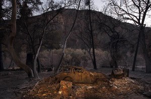
An incinerated car sits in the devastated hamlet of Vogel Flats, which is along Big Tujunga Canyon Road in the Angeles National Forest, in September of 2009 . Credit: Luis Sinco / Los Angeles Times

Roughly $700,000 has been earmarked for improving the forest roads and trails that were destroyed last year during the Station fire, officials said. 

Rep. Adam Schiff (D-Burbank) secured the earmark in the Interior Appropriations bill for restoring the 160,577 acres of scorched landscape that’s in severe need of restoration. 

“The roads and trails have been eroded and degraded,” said Richard Toyon, former forest ranger and president of the local nonprofit Volunteers Organizing in Conserving the Environment. 

Trekking on some trails in the forest is challenging because they eventually disappear, he said, and some roads and trails are no longer recognizable. 

The bill must still pass the full House and Senate before reaching President Obama’s desk, said Schiff’s spokeswoman, Maureen Shanahan. 

If the bill is approved, the funding would be allocated to the U.S. Forest Service to handle the restoration work. 

“This funding will help repair the roads and trails that were damaged in the fire to restore safety and access for families to enjoy one of California’s greatest natural resources,” Schiff said in a statement. 

Engineers for the Angeles National Forest have estimated that about 300 miles of roads and 225 miles of trails were harmed during the Station fire, according to Schiff’s office. 

Damage to roads and trails worsened due to erosion and landslides during the winter. 

Gov. Arnold Schwarzenegger on Feb. 11 declared the footprint of the fire a disaster area. 

Some of the roads have been closed due to the extensive damage, and trails that have been deemed unsafe for hiking have been off limits. 

Officials are planning to focus the funding on the most critically damaged roads with the largest access points. 

Some road improvements include installing retaining walls, reconstructing low water crossings, grading surfaces, repairing drainage, repaving and restoring signage, according to Schiff’s office. 

Trail improvements include drainage repairs, re-stabilizing slopes and restoring walking surfaces. 


Angeles Crest Highway closures cause confusion and frustration

Wednesday, July 28th, 2010

From the Los Angeles Times  

Hundreds of hikers and bicyclists have been spotted in areas closed for construction. Some are genuinely unaware of the roadblocks along the popular trails, while others trespass out of defiance.  

With a small day pack strapped to his back, Scott Groves set out from his home in Pasadena to the foot of the Mt. Wilson Trail in Sierra Madre. He climbed seven miles to the top of the mountain and then proceeded down Mt. Wilson Road before happening upon the closed portion of Angeles Crest Highway.  

About 20 miles of the 66-mile Angeles Crest Highway is closed for construction. The $16.5 million in road repairs is expected to be completed in November. (Raul Roa, La Canada / July 6, 2010)

“It wasn’t even on my radar that this was closed,” Groves said as he stopped to fill his water pouch near the intersection of Angeles Crest and Angeles Forest highways. “I had read that it was clear to come up from the Palmdale side, so I figured everything here was cool.” 

About 20 miles of the 66-mile Angeles Crest Highway, from La Cañada Flintridge to Mt. Wilson Road and 25% of the Angeles National Forest remain off-limits to the public as construction crews rebuild pieces of the route that winter storms caused to wash out. The $16.5 million in repairs, contracted out to Thousand Oaks-based Burns Pacific Construction, is expected to be completed in November.  

Meanwhile, the closures continue to frustrate and confuse those seeking to access some of the most popular portions of the San Gabriel Mountains. Hundreds of motorcyclists, bicyclists and hikers have been spotted in restricted areas, according to officials from the California Department of Transportation and U.S. Forest Service. Some of the trespassing seems to be due to genuine misunderstanding about the status of different portions of the road and forest.  

In late June, Caltrans Public Information Officer Patrick Chandler intercepted a dozen members of a family setting off on a hike.  

“They parked at Angeles Forest Highway where it meets Angeles Crest and walked up to the closure and were going to go down to Switzer Falls,” Chandler said.  

He had to explain to the family that the popular trail was closed. But hikers have not been alone in their confusion: Road repair workers reported that Los Angeles County public safety personnel have attempted to respond to emergency calls by traveling north on Angeles Crest Highway, only to hit roadblocks.  

Los Angeles County Fire Battalion Chief Mitch Brookhyser confirmed one such incident. On May 31, units from La Cañada Flintridge’s Station No. 82 responded to a call of a motorcycle that had gone off the side of Angeles Crest, Brookhyser said. The responders were forced to stop at a locked gate. The call was canceled minutes later, he said.  

Many of those entering closed portions of the highway and forest, however, are doing so with overt disregard for clearly posted signs, Chandler said. A Las Vegas motorcycle crew posted on its blog a dozen photos of members circumventing closures and being cited by the California Highway Patrol during an outing in May.  

And on a recent afternoon, Jim Blake, a Lake View Terrace resident and avid bicyclist, stopped to watch workers repair a 200-foot-deep washout near Brown Canyon — the largest of the two dozen damaged spots. He had pedaled 27 miles, traveling on Big Tujunga Canyon Road, Angeles Forest Highway and Angeles Crest Highway.  

“Big Tujunga Canyon was open,” Blake said. “Then they had some signs on Angeles Forest Highway that it was closed ahead, but cars could go through. At Angeles Crest Highway they had a gate, but I could get through there.”  

He enjoyed having the road to himself, Blake said, although he did have to steer clear of a couple of dump trucks.

The Great Outdoors Initiative Comes to L.A.

Friday, July 9th, 2010
On July 8th CORBA volunteers attended a “listening session” with such dignitaries as Mayor Antonio Villaraigosa, Secretary of the Department of the Interior Ken Salazar, E.P.A. Administrator Lisa Jackson, Chair of the White House Council on Environmental Quality Nancy Sutley, Undersecretary of the U.S. Dept. of Agriculture Harris Sherman and Asst. Secretary of the Army (Civil Works) Jo-Ellen Darcy.  Also represented were Los Angeles City and County department heads, and leaders of hundreds of NGO’s all gathered for this“listening session” by Obama’s environmental “dream team” on-stage.
Each panel member spoke about the challenges in providing recreation, conservation and appreciation of the great outdoors. The speakers discussed how Los Angeles is continually misrepresented as the capital of sprawl, a car culture, a place lacking in the great outdoors. Many Angelenos already enjoy the great open spaces that surround us in the San Gabriels, Santa Monicas, the Arroyo, the LA River and Griffith Park. Most people in the city, however, are unaware of just how much open space is so close by.

An inspiring video outlining the challenges and achievements of the nation’s public lands was shown. The video is available on the DOI web site.

In the audience, local government officials sat side by side with advocates, educators, non-profit directors and conservationists to share their experiences and express their views to the federal representatives. The room was packed to capacity, with over 800 people in attendance.

These high-level Administration officials and White House Cabinet members listened to comments from the audience for about an hour, after which a more intimate opportunity for feedback was offered by way of break-out sessions.

During the public comments, many pointed out the noticeable absences from the panel: Transportation and Education.
Many contended, and CORBA agrees, that getting people outdoors can be achieved by either bringing the people to the outdoors by providing a  better public transport network that reaches the surrounding open space as well as existing city parks; and walkable, livable streets where bicycle transportation and recreation is encouraged and welcomed.

The second option is bringing the outdoors to the people. This is exemplified by grass-roots movements like Ciclovia where several city streets will be closed on September 12th to create a one-day 13 mile long playground for riding, walking and just being outside. The initiative seeks a better balance in zoning and utilization of park land, development and infrastructure: building more livable communities. It encourages urban parkland development and recreation.

Much was said by panelists and public about the need to protect natural resources. In CORBA’s opinion not enough was said about the need for access to those protected resources as recreational opportunities. During breakout sessions CORBA board member Steve Messer brought up the need for alternatives to wilderness designations which exclude user groups and make public land more inaccessible for the majority. Access and conservation are synergistic in many ways: when people can’t or don’t experience these lands, they don’t develop a sense of stewardship or understand the need to conserve.

CORBA’s mission includes preservation, stewardship and access for mountain bikers and the trail systems they ride. Our Youth Adventures, Introduction to Mountain Bike Skills clinics, and Trail Crew programs give people a sense of those values.

Messer also brought up the fact that bicycling is a life-long health-promoting recreational activity. He talked about the Interscholastic Cycling League and the collateral long-term changes it will bring about. Unlike more traditional high school team sports, high school mountain bikers are much more likely to continue to participate in this health-promoting activity well beyond their high school years. He stressed the need to support youth programs, high school programs, and trail access for all users in our City Parks (bringing the outdoors to the people).

For such a diverse group, the breakout session in which CORBA participated went very smoothly, with all the participants tending to agree on most things: The need for funding; The inclusion of alternative transportation; The need to coordinate agencies; The need to bring the classroom outside. Equestrian representatives talked about their youth programs in Compton that allow kids the opportunity to experience a ranching lifestyle. A science teacher talked about his inability to take kids out into the field because of budget cuts. Others referred to “every child left inside, AKA no child left behind.” Other salient points were expressed: the lack of communication and cooperation between government agencies; the need for federal governments to work more at the local level while allowing locals to have a bigger hand in managing lands.

In all, the process went well and–at least in the breakout session CORBA attended–all felt they were heard, and all had something to say. There was no animosity between any of the groups present, from the Sierra Club, to CORBA, to the equestrian community, OHV community, to educators and local government representatives.  If anything, there seemed to be a subtle acknowledgement that all those present have a love of the outdoors, despite the differences in how we experience it.

The goal of this initiative is to produce a set of recommendations expected to be ready in November. All of the comments were recorded and will be considered. The recommendations that result from these listening sessions will help shape policy that will see us through the next hundred years of management of public lands.

Though the term “mountain bike” is relatively new, bicycles are an integral part of America’s history, and have been used in the outdoors since the late 1800’s. Mountain bikers are now part of that history and deserve the same respect when it comes to decisions about outdoor recreation. We need to make sure that we are considered in those decisions.

For those who were not at the listening session, you can make comments online at http://ideas.usda.gov/ago/ideas.nsf/. You can also vote down or vote up the comments of others, or respond to others’ comments. It is a lively discussion, and currently there are anti-mountain biking comments that have been voted down. We need to flood their system with comments supporting mountain biking and access.

The initiative asks individuals and organizations to express what they see as the Challenges, What Works, The Federal Government’s Role and the Tools needed to make it better. Submit your comments and be heard.

CORBA’s preliminary thoughts (our official statement will be made public soon):

Challenges: We face an obesity epidemic and declining participation in outdoor activities. We have mismanaged lands for hundreds of years, allowing sprawl, poorly designed cities and a lack of open space. We need to find, connect to, allow access to and protect public lands. Bicycles, both on and off-road, are a part of that solution.
What Works: We have found that getting access to trails, whether in mountains or city parks, encourages park use and outdoor participation. Mountain Bikes blur transport and recreation lines, and entice people out of doors with healthy exercise disguised as fun. Cycling should be encouraged in all its forms.
Federal Role: The federal government needs to expand trail networks and access for everyone. It should utilize alternative land protection designations that allow for more recreation and more jobs while protecting the land, instead of wilderness designations which by their nature are exclusionary and decrease opportunity.
The Tools: The NEPA and CEQA processes must be overhauled and streamlined; alternative protective designations to wilderness, and establishing better ratios of trail miles to user populations on federal lands. Fund projects at the local level. Fund jobs that expand access to open spaces. The NPS needs to adopt the proposed 2008 rule change (36 CFR 4.30, Federal Register E8-29892) that makes it easier for NPS unit superintendents to open off road facilities to mountain bikes. The current rule is onerous, burdensome and expensive. It deters NPS units from offering off-road cycling opportunities.
Please submit your comments, or take those we’ve suggested and modify them as you see fit.
Comments can be submitted right now at http://ideas.usda.gov/ago/ideas.nsf/. You can have your say and it will be counted.