Archive for the ‘Advocacy’ Category

Sullivan Canyon Officially Re-opens

Wednesday, March 19th, 2014

image001By Mike Harriel, Southern California Gas Company

So Cal Gas has completed mandated maintenance work on the pipelines in Sullivan Canyon. The canyon is now open for use.

As I have mentioned before. There is another maintenance project occurring in the canyon in early May 2014. I will inform you about the impact to the canyon as well as timeline once I have all the information.

Please be aware; at the end of the Sullivan Fire Road north of Mulholland Drive, Southern California Gas Company (SoCalGas®) will soon be working in the area to perform a pressure test on one of our natural gas pipelines. You will see SoCalGas and its Contractor’s trucks, water tanks, and heavy equipment.

I know a lot of you use this road for hiking and biking. My understanding is the road will not be completely blocked so you will be able to pass through. Work will begin late March 2014, and last until approximately early in May 2014, although weather and other factors affecting safe working conditions could change the schedule.

Thank you for your patience regarding Sullivan Canyon closures. Please understand Sullivan Canyon is private property, owned solely by the southern California gas company. Its primary function is a corridor for two high pressure gas lines. Because of its natural beauty, we make it available for public use. Periodically, we must complete state and federally mandated maintenance on this pipeline to insure its integrity and public safety. This maintenance may require partial or complete shutdown of the canyon, depending on the nature of the work. We try to keep the public informed of this work, scheduling and user impact.

Please let me know if you have any questions.

Happy hiking and biking!


LA County: Santa Susana Mountains Trails Master Plan Update

Wednesday, March 12th, 2014
Santa Susana Mountains Trail Master Plan Meeting

Kathline King introduces the SSMTMP

At last weeks second public meeting on the Santa Susana Mountains Trails Master Plan, the County presented a comprehensive map showing their planned trails, the existing trails, and the relevant delineations of private, public and utility lands. While public comments were made, they weren’t being recorded.

CORBA would like to express our sincere thanks and gratitude to L.A. County Parks and Recreation Planning Division staff for moving this trail plan forward, and to Supervisor Antonovich for his support of the process. CORBA whole-heartedly supports project, the process, and the deliverables (maps) presented at the meeting last week.

In looking at the final draft map, we were pleased to see that the agency had listened to the prior comments asking to expand the study area so that true connectivity between disparate open spaces and existing trails could be explored more thoroughly and with a more regional view.

From our cursory review of the maps presented at the meeting, we can say that the work that has gone into this planning effort has been very much worthwhile. We feel the document is a great step towards achieving the stated goals of identifying missing links, providing connectivity between existing trails, open spaces and jurisdictions, and recognizing the value of some of the existing non-system trails. We feel the eventual implementation of the plan will increase both the quality, quantity, and variety of recreational experiences the community so badly needs.

We are also sensitive to the concerns of private property owners who expressed feelings that they hadn’t been heard. However, we also feel that many of their concerns arose from an incomplete understanding of the goals of this planning process. In some cases, it seemed their negative experiences with other neighboring public land managers have elevated their concerns about dealing with the County. We hope that as the plan is implemented and negotiations take place with private land owners (and the neighboring public land managers), their fears can be allayed and mutually beneficial compromises reached for the benefit of the entire trail user community and the public-at-large.

The County’s policy favoring shared-use trails including bicycles is very important to us as a trail advocacy group comprised of bicyclists. We know that there are several places where proposed County trails will connect to trails in City of Los Angeles parks such as O’Melveny and Limekiln Canyon. On these City trails bicycles are presently prohibited. It is our hope that the County and City can come to a compromise that would allow bicycles to connect legally to the proposed County trails/trailheads that are only accessible through City property and trails.

Since this Trail Master Plan will be incorporated into the County General Plan, we feel it would also be worth coordinating proposed trailheads with the 2012 L.A. County Bicycle Master Plan. Having trailheads accessible by bicycle-friendly infrastructure such as Class II Bike lanes is good for encouragement, makes them more accessible to non-drivers, and helps reduce vehicular traffic to trailheads.

CORBA is at present in full support of the plan. It will be presented to the County Rec and Parks Commission later in the year, and subsequently to the L.A. County Board of Supervisors for adoption.

Update March 16, 2014: The plan will be presented to the Planning Commission on March 26, 2014. Meeting starts at 9 am at the Hall of Records Room 150, 320 W. Temple Street, Los Angeles, California 90012. The Parks and Recreation element is agenda item #6.i.

The Trail Master Plan map and powerpoint presentation are available on the County’s web site.

Update, March 26, 2014: The LA County Regional Planning Commission held their hearing on the draft plan today. Steve Messer, Jim Hasenauer, Ken Raleigh and Tony Arnold all testified in support of the plan. One private landowner, and five equestrian representatives also testified in support of the plan, all of them mentioning multi-use trails. Nobody spoke against the plan. Other elements of the County General Plan were also presented to the Commission, who held the matter over until their next meeting in April. We are confident the Planning Commission will approve the plan, which will then go before the Board Of Supervisors later in the year.

LA County’s Draft Santa Susana Mountains Trail Plan

Wednesday, February 12th, 2014

2014-03-06-Santa-Susanna-meeting

In 2012, CORBA attended public meetings to give input on L.A. County’s Santa Susana Mountains trails master plan. The County has taken the input we and many others gave, and will present their draft Trail Master Plan at a public meeting on March 6 in Granada Hills. They will also seek additional feedback from the trail user community.

The area under consideration for this trails master plan included the unincorporated open space north of Chatsworth, up to the crest of the Santa Susana Mountains. In our comments, and many others submitted by the public, we urged that the project area be expanded north to the LA County border, and east to incorporate the entire northern range of the San Fernando Valley.

The County will present the draft trail master plan at:

Thursday, March 6, 2014, 6:00 p.m. – 8:00 p.m. 
Knollwood Country Club,
Granada Room
12024 Balboa Blvd, 
Granada Hills, CA 91344
Parking is free. 


Santa Monica Mountains Draft Trail Management Plan Released

Friday, January 31st, 2014


smmtmp-coverOn Friday, January 31, 2014, CORBA was notified that the long-awaited Santa Monica Mountains Draft Trail Management Plan (TMP) had been released in draft form for review. In developing the plan, NPS supposedly inventoried all existing trails, including “unofficial” or “volunteer” trails, and lays out a vision for how the entire trail system will be managed going forward. The plan has been in development for more than ten years, with several false starts and periods of uncertainty due to dwindling budgets, lack of staff and other limitations. The NPS last year received a grant to complete the plan.

Now that the draft has been released, we will be going over it in detail over the coming weeks  to see whether our concerns have been given due consideration. We’d encourage everyone familiar with the trails of the Santa Monica Mountains to see if there are any trails they know of that will be affected by the proposed plan.

CORBA has a long-standing request for bicycle access to particular trails that are currently closed to bikes. Our list goes back more than two decades, but our formal requests were, at least in part, the impetus for State Parks to develop their formal Change In Use (CIU) process. So far, two trails for which we requested a change in use have been evaluated using the CIU methodology. One of those, the Canyon trail in Placerita Canyon (a State Park unit managed by L.A. County) was reviewed and opened to bikes after trail modifications were made. The other trails that were approved for a change in use have been on hold due to a lack of funds, a need for major re-routes, and pending the final release of the TMP.

We’re hoping to see the trails for which CORBA has formally requested a Change In Use, a list that goes back more than a decade, have been given due consideration in the TMP. We’re also hoping to see plans for new trails to provide better through-connectivity, including a multi-use bypass trail around the Boney Mountain State Wilderness, among other things. We’d also like to see the Backbone trail opened in its entirety, or viable multi-use singletrack alternate routes for sections that can’t or won’t be opened to bikes.

The TMP document is complex. Since the Santa Monica Mountains National Recreation Area includes land owned by multiple agencies, it was quite an undertaking to coordinate the effort between the affected agencies: State Parks, National Park Service, Mountains Recreation Conservation Authority, Santa Monica Mountains Conservancy, LA County, private landowners and others.

The plans can be downloaded for viewing at:  http://www.nps.gov/samo/parkmgmt/tmp-index.htm.  The public comment period ends on April 1st. We aim to have reviewed the documents in detail and offer our assessment and comment suggestions by the end of February.

Two Public hearings are scheduled, and we encourage anyone with an interest in the trails of the Santa Monica Mountains to attend:

February 20, 2014, 6:30 – 8:30 p.m. 
King Gillette Ranch 
Dining Hall 
26800 Mulholland Highway 
Calabasas, CA 91302  
 
February 22, 2014, 10:00 a.m. – 12:00 p.m.
Temescal Gateway Park 
Woodland Hall 
15601 Sunset Blvd. 
Pacific Palisades, CA 90272 


Change Is Good

Wednesday, January 29th, 2014

By Mark Langton

As CORBA’s president for the past two years it has been my honor to represent the interests of  backcountry trail users in the common goal of cooperative shared use open space trails.

As of January 27 I  resigned my position as president, but will continue to act as secretary as well as being on the board of directors. I felt that it was time to allow new and fresh leadership to guide CORBA moving forward. I am happy and very excited to announce that CORBA’s vice president Steve Messer has accepted the nomination to president. Steve brings an incredible wealth of volunteer experience with the Angeles National Forest mountain bike patrol and trail crew, as well as heading up trail work with CORBA’s trail crew. As a CORBA board member for the past four years Steve has written numerous documents pertaining to a variety of shared use trail issues. I have every confidence that Steve will completely represent CORBA’s interests at the various land management and public meetings that we attend on a monthly basis.

I can assure you that that this transition will be seamless and will not effect the operation of CORBA in any way, except to reinforce our resolve to keep pressing to gain as much access to our public trails as possible. Onward!


Sullivan Canyon Pipeline Work Begins January 6

Friday, December 20th, 2013

From the Public Affairs Office of Southern California Gas:

Since 1960, Southern California Gas Company (“SoCaIGas”) has owned much of the land that comprises Sullivan Canyon (more than 4 miles in length). This property is used as a corridor for two transmission pipelines that provide Los Angeles residents with a safe and reliable supply of natural gas. Periodically, SoCalGas must perform maintenance on these pipelines. The purpose of this letter is to provide information on pipeline maintenance and repair work that will occur in 2014.

Purpose of this Work

We recently internally inspected our pipeline. By code, we have areas we are required to perform a visual inspection of the pipeline as part of a validation process. This work is required to maintain the pipeline’s safety and integrity.

Location and Logistics

There are two work areas along the access road within the canyon that will require excavation.

Location 1: 0.7 (seven tenths) of a mile south from fire road #26 at the Mulholland entrance

Location 2: 2.8 miles in from fire road #26, or 1.4 miles from the Queensferry entrance

Partial Canyon Closures

The Canyon path will be closed from the Mulholland entrance at fire road #26 to location 1.

There is no change to the Queensferry entrance. Signs will be posted along the path indicating construction status.

The following impacts are to be expected in the canyon and surrounding neighborhood. I will keep you apprised of any changes.

-Work will commence on or about January 6, 2014.

-Work is estimated to be completed in 8 weeks.

-Information signs will be posted in advance at the beginning of each entrance.

-Work hours are sun up to sun down, Monday through Friday. No work will be performed on Saturday and Sunday.

-Intermittent loud noise in the immediate work areas.

-Increased dust in the immediate work areas.

-Increased traffic at the Mulholland entrance from work crews and equipment.

SoCalGas appreciates your understanding and apologizes for any inconveniences caused by this necessary work. It is our goal to minimize disruptions. We value our relationship with the community and will communicate with you when our work has the potential of impacting our neighbors. Again, there are two high-pressure transmission pipelines located in the canyon and we will continue to periodically perform maintenance work to them as-needed to ensure safety.

Safety is our first priority. Should you have any questions, please call me 213 244-4633 or email me at mharriel@semprautilities.com.

Sincerely,

Mike Harriel

Public Affairs Manager

Angeles National Forest Recreation Fee Proposed Changes

Saturday, December 7th, 2013

Adventure PassThe Forest Service has proposed major revisions to the Angeles National Forest recreational fees. Similar revisions are proposed for the San Bernardino National Forest, Cleveland National Forest and Los Padres National Forest.

The proposed changes will result in fees being required only at concentrated, developed sites, while larger areas of the forest will become free for public use. Fee amounts will remain the same, at $5 for a day pass, or $30 for an annual adventure pass.

Under the new fee structure, fees are to be charged only where there are services and developed facilities including bathrooms, kiosks/interpretive signs, trash collection, picnic tables and security patrols. Sites lacking one or more of the above will be free.

In the Angeles Front Country, for example, fees  would continue to be required at Millard Day Use Area, Switzers Picnic Area, Red Box, Skyline Park (Mount Wilson), and Chantry Flats. All other front country areas would become free for public use. Note that the forest service has already stopped enforcement of passes at the areas where fees will be dropped under the new fee structure. Full details of front country changes are available here.

While CORBA supports this more reasonable and appropriate fee structure, we do have concerns that it may result in reduced levels of service across the National Forest as a whole. The financial impacts of the proposed changes are as yet undetermined. National Forest budgets have faced continued reductions over the past decade, and staff levels are at an all-time low. Recreational Fees have helped fill the budget shortfalls, funding numerous improvements to facilities within the National Forest.

The California Recreational Resource Advisory Committee (R-RAC), a citizen’s Federal Advisory Committee, is charged with representing the public interest in matters of recreational fees and other issues. The proposed changes are on the R-RAC agenda for for January 15-16, 2014. Public comments to the committee must be made by January 6, 2014, emailed to: twilton@fs.fed.us.

Area maps and detailed descriptions of the affected areas of the Angeles National Forest can be found at:

For our other Southern California National Forests, visit their respective pages at:


Tell Los Angeles Recreation and Parks What You Want

Wednesday, November 27th, 2013

rec and parks logoThe City of of Los Angeles Recreation and Parks Department (RAP) is seeking public input on the future and funding of our City parks. This is being conducted through a series of public meetings, and an online Community Budget Discussion survey

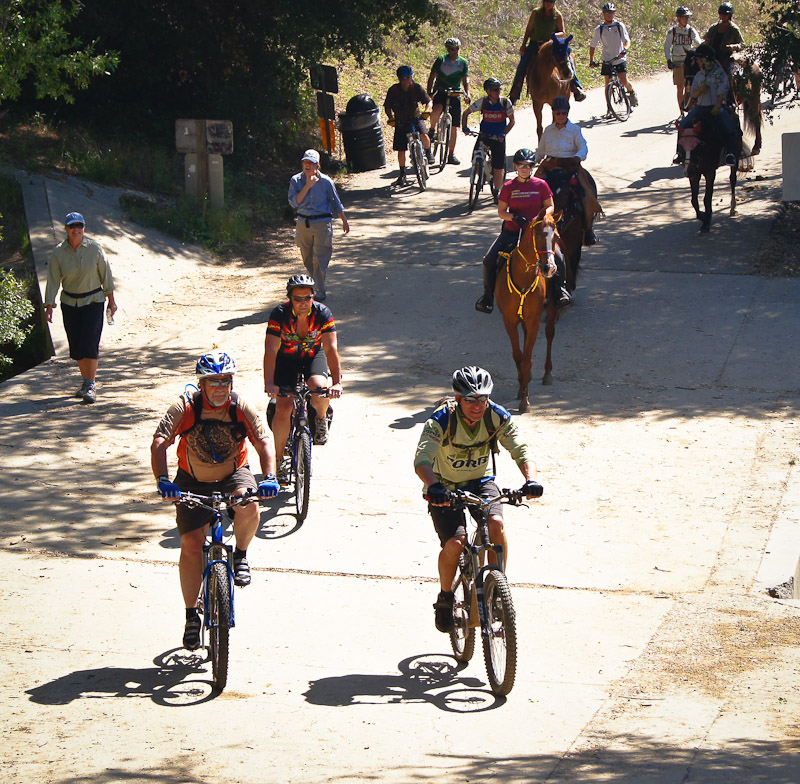
We are taking this opportunity to remind RAP of their obligations and duties as identified in the 2010 Los Angeles City Bike Plan. CORBA worked diligently to keep the meager provisions for off-road cycling in the 2010 Bike Plan, while the powerful equestrian lobby fought hard to have them removed. We submitted over 1000 letters and petition signatures calling on the City to include strategies for accommodating mountain bikes on at least some City trails. We also asked that a recommendation for Bike Parks be included in the Bike Plan, but a Bike Park provision was not included in the final plan.

Havemeyer Park, a pop-up bike park facility in Brooklyn

Havemeyer Park, a pop-up bike park facility in Brooklyn

The City has made remarkable progress on the implementation of the Bike Plan, at least where the Department of Transport is the lead agency. The five-year implementation strategy is ahead of schedule with regards to new bike lanes and other infrastructure supporting cycling on the City’s streets.

To our knowledge, nothing has yet been done to implement the off-road cycling provisions identified in Chapter 4, Sections 3.3.5, 3.3.6, and 3.3.7 of the 2010 Bike Plan. The lead agency identified for those provisions is RAP.  The Bike Plan calls for these provisions to be completed by 2015.

We therefore urge all of CORBA’s members who live within the City of Los Angeles to complete the survey. The survey is available at http://laparks.org, where a popup window will direct you to the survey. The survey can also be accessed directly at http://m.laparks.org/survey/#survey, but please read on before doing so.

The RAP survey will ask how often you visit City parks, what activities you participate in, how far would you travel for specific activities, and what amenities you would like to see. Nowhere within the survey is there any mention of bicycles, trails for bicycles or bike parks. You must write those in where appropriate.

While “equestrian trails” and “hiking/walking” trails are referred to in the survey, there is not a single mention of bicycle trails or multiple-use trails. Also missing is any mention of Bike Parks. Therefore the only opportunity within the survey to request park facilities for bicycles, such as trails, pump tracks or bike parks, is in the “Additional Comments,” section 9.

We encourage our members and readers to take the survey, and in the “Additional Comments section,” urge the RAP department to:

The Recreation and Parks Department needs to allocate the necessary resources to complete the programs for which it is the lead agency as identified in Chapter 4, Sections 3.3.6 and 3.3.7 of the 2010 Bike Plan. Numerous funding sources in the form of bike industry grants, community health and wellness grants, and youth initiative grants are available to fund and support bike skills parks and multiple-use trails, as well as sponsorships and public-private partnerships. RAP needs to provide natural-surface trails for bicycles, and should consider developing urban bike skills parks, with a range of skills development features that are suitable for all ages and skill levels. 

You may copy and paste the above paragraph to post under “additional comments”, but feel free to provide your own input for the survey. Additionally, section 6 asks surveyees to rank or prioritize desired facilities. Bike parks are not mentioned, but can be written in under option W: “Other, Please Specify.”

Core to the survey is the identification of sources of revenue to fund the City’s parks. There are many funding options in the form of bike industry grants available for the construction of bike parks and multi-use trails. There is also a ready and willing army of volunteers who would gladly help build and maintain bike parks. However, the City must first undergo a change in attitude towards off-road bicyclists, just as it has seen a change in attitude towards road cyclists and bike commuters.

A series of public meetings are being held, some of which have already taken place. A full list of them is available at http://www.laparks.org/pdf/comInput.pdf. Meetings are from 6:30 – 8 p.m. For more information, contact Theresa Walker, theresa.walker@lacity.org, at (213) 202-3205.

CD1 – December 4: Ramona Hall Community Center, 4580 North Figueroa Street
CD3 – December 3: Woodland Hills Recreation Center, 5858 Shoup Avenue
CD4 – December 9: Griffith Park Visitor’s Center, 4730 Crystal Springs Dr.
CD7 – December 10: Ritchie Valens Recreation Center, 10736 Laurel Canyon Boulevard (Pacoima)
CD8 – December 3: Algin Sutton Recreation Center, 8800 South Hoover Street
CD9 – December 12: EXPO Center, 3980 South Bill Robertson Lane
CD10 – December 4: Rancho Cienega Sports Complex, 5001 Rodeo Road
CD14 – December 2: City Hall, 200 N. Spring St. Public Works Board Room
CD14 – December 3: Evergreen Recreation Center, 2844 East 2nd Street
CD15 – December 5: 109th St. Rec Center, 1464 E. 109th St.

Edit: CORBA’s response letter to Rec and Parks can be read at: 2013-12-02-Los Angeles Rec and Parks Letter.

City of Fillmore Considering a Pump Track TONIGHT, November 12th!

Tuesday, November 12th, 2013

Pump TrackFillmore City Council meeting TONIGHT at 6:30 to consider putting in a pump track! Fillmore City Hall, 250 Central Ave., Fillmore. Please come out and show your support!

What CORBA Does

Wednesday, October 30th, 2013

By Mark Langton

Bikes, horses, hikers and runners

Bikes, horses, hikers and runners. We all love trails.

Recently a bicycle club-team representative  contacted CORBA wanting to see what more they could do to get more of the trails that are currently closed to bicycles opened up to shared use. A couple of comments from the correspondence were that they thought that showing up in larger numbers to public meetings would help, and that they thought the main reason that trails were closed were because of an influential public anti-bicycle lobby.

I wrote back to the person who contacted me, and in doing so came up with what I think is a good overview of what CORBA has been doing for the past 26 years, and continues to do on behalf of all public backcountry trail users (see below). Yes, CORBA is a mountain bike organization, but we are more than that, and here’s why: We believe that shared use works better because it disperses use, rather than concentrating it. When you disperse use, you reduce congestion, and when you reduce congestion, you reduce confrontation. Moreover, it has been shown that where shared use trails exist, it works. Maybe not perfectly, but certainly better than where there are restrictions to bicycles, because shared use also fosters cooperation. Bicycles do mix when operated considerately and with the safety and serenity of other trail users in mind. And that’s the crux of the issue: If bicyclists would simply slow down around others, including other bicyclists, they would be solving the problem of both dangerous speed, and the “startle factor,” or the disruption of another’s peaceful enjoyment of the backcountry.

Here’s what I wrote to that bicycle club team member:

This year CORBA celebrated its 26th anniversary. In that time we have made many strides to opening trails to shared use (hiking, equestrian, bicycle) in the Santa Monica Mountains National Recreation Area, Angeles National Forest, Los Angeles County, and Eastern Ventura County. We have participated in hundreds of public meetings with land managers over the years. Land managers recognize and continue to adapt to the growing bicycle population and changing demographic profile of the trail user community. They are certainly aware of the needs and desires of the mountain biking community through CORBA’s efforts, which include quarterly meetings with principal agency managers (National Park Service, State Parks, Mountains Recreation and Conservation Authority). We are also in constant communication with these agencies and/or when the need arises to address a specific issue. CORBA also works closely with the Mountain Bike Unit which aids the rangers and community with safety and education. CORBA also schedules and organizes regular trail maintenance work days s in conjunction with the Santa Monica Mountains Trails Council and Conejo Open Space Conservation Agency. CORBA is also heavily involved with the Angeles National Forest with trail maintenance and volunteer patrol participation. Due to CORBA’s efforts, most of the singletrack trails built in the last 25 years are shared use (not to mention a lot of the singletrack that already existed not getting shut down).

 As you can see, there is more to getting involved than just showing up at meetings in large numbers. The issue of bikes not being allowed on trails is more than just politically active opponents to bicycles; it is mired in an outdated management policy of restriction that is predicated to a large degree on ignorance and a status quo mentality. Within the last few years there has been a systemic change for adopting shared use as the overriding management strategy. It is a slow moving process but we do see a very strong indication that within the next few years we will see many more trails opening to shared use on a statewide basis than currently exists. This change comes from consistent efforts not only by CORBA, but mountain bike advocates all over the state, with assistance from the International Mountain Bicycle Association (of which CORBA was a founding club in 1988).

 The one concern that is always at the forefront of managers’ minds is safety. It is agreed by everyone that bicycles are an acceptable form of public open space trail recreation. However, it is when riders go too fast around other users as to make it an unsafe or even just an unpleasant experience that gets mountain bikers a bad reputation, and gets the managers to thinking about restricting bicycles. If everyone would just slow down when passing others, and slow down into corners so they don’t scare others on the other side, we would pretty much solve the problem. I am not saying you shouldn’t go fast, I’m just saying do it when conditions are safe.