CORBA Home Page
The voice of off-road bicyclists


Archive for the ‘Santa Susana Mountains’ Category

Bike Thefts On The Rise–Again

Friday, July 3rd, 2015

Evidently there has been a rash of bicycle thefts that have hit several CORBA members within the last month. While it is not known if the perpetrators are part of an organized ring, LAPD officer John “Rusty” Redican thinks it sounds a lot like a gang that was operating out of South Los Angels a few years ago. Click here for the link to MTBR to view his post and see photos of the thieves that were arrested a few years back. Below is the text of his post:

Hello All, My name is John (Rusty) Redican, I’m a fellow cyclist and LAPDOfficer. This reminder is not an official LAPD news blast, but me as a fellow cyclist and community member arming you with a little information to keep you and your property safe. Due to another salient event, where a fellow cyclist had his bicycles stolen out of his garage.

I need to advise you all about a ring of high end bicycle thieves that we (LAPDWest LA Division) arrested a couple years back, who may or may not be at it again. That arrest was only made possible due to cooperation between the cycling community and the police. First off, be very cautious on what you post on social media, i.e. Facebook, Instagram, Strava and similar forms of tracking and communication we all use for our shared love of cycling.

A few years back, this ring of bike thieves, based out of south Los Angeles, were responsible for millions of dollars of bicycle thefts, from San Diego County to Ventura County. They would follow cyclists home from group rides, scour FaceBook and other social media for intel on cyclists and their homes, so they could conduct surveillance on you and break into your garage or storage areas to steal your bicycles. They would do this during the day mostly when no one was home, but also at night while you slept. At times they would cause damage to the garage, but most times they were very surreptitious about it and the only evidence left, was the absence of your property. The majority of the bikes they targeted were well worth (as you all know) the chance for them to get caught by the home owner. At the time, they used a very clean and newer model silver, 4 door Audi sedan with bike racks on it. The suspects in the cases I’m referring too were all male hispanics in their mid to lat 20’s – early thirties, between 5’6” and 5’9”, 175 lbs to 220 lbs, not climbers. Again, I’m not saying this is definitely them, but the MO used in the theft of bikes from one of our fellow cyclists in Torrence, last week is very similar.

So be advised and be cautious of what you put on social media, NEVER have the starting point to your ride be your residence, and be cautious on who you share your photos and information with. Also, you don’t have to be paranoid, but be aware of your surroundings and if you notice a vehicle following you, or the same vehicle in 3 different locations, that may be a clue, and take not of the lic plate number, or any other distinguishing characteristics of the vehicle and occupant(s). Criminals are not dumb, and have evolved with the technology, so a little operational security will help you keep your property that you love, and work hard to obtain. If you see anything suspicious please be a good witness, don’t physically get involved, as you never know what these criminals are armed with, but immediately call your local police department.

Anyway, I put this info out not to alarm, but to inform, for-warned is for-armed. Please share with your cycling teams and groups, or any cycling friends who may benefit from this information.

These are the suspects from 2012. This photo is from CBS Los Angeles. They were apparently seen today in Corona at Corona High checking out the mountain bike teams bikes and asking questions… They are now driving a black newer model Honda Accord….FYI…


Rim of the Valley Corridor Study

Tuesday, June 30th, 2015

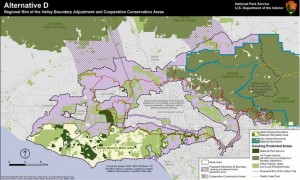
ROTValternativeDCORBA has been involved in the Rim of the Valley Corridor since our inception. In fact, we’re so ingrained in the process that the Rim of the Valley Corridor is mentioned in our mission statement as our primary territory of concern. We were excited to see the draft study released, and have submitted comments on the plan.

The study sought to answer the following:

1. Does the area possess nationally significant natural or cultural resources?
2. Is it a suitable and unique addition to the National Park System?
3. Can it be feasibly added to the Park System?
4. Does it require direct NPS management, instead of stewardship from other groups or a public-private combination?

The answer to all of the above questions was a “yes.” The National Park Service presented four alternatives based on the study findings. The first NEPA-required “no action” alternatives serves as a baseline against which we can compare the alternatives. Alternative B allows the NPS to offer “technical assistance” to existing land managers within the study area, but falls short of allowing the NPS to make any direct capitol investments.

Alternatives C and D expand the authorized boundary of the Santa Monica Mountains National Recreation Area. What the boundary expansions really mean is that the National Park Service will be authorized to offer technical assistance to existing land managers for any project that enhances recreation, or restores habitat and connectivity. Under Alternative C or D, the NPS is also authorized to spend money on capitol projects within the expanded boundaries.

We believe that the largest operational boundary proposed under Alternative D would have the greatest long-term benefit for recreation, bio-connectivity, wildlife and the communities adjacent to the study area. It also includes the wildlife corridors linking the two areas of the Angeles National Forest separated by Highway 14, as well as between the Santa Susana Mountains and Los Padres National Forests.

The boundary expansion does not come without concern. The NPS, like most public land agencies, is currently under-funded. We would hope that any boundary expansion would come with an increase in funding sufficient to at least maintain the current level of service across the expanded NRA.

During the course of the public meetings we heard a lot of misinformation and a misunderstanding of what the boundary expansions mean. The Federal government will not be taking anyone’s property against their will. Existing land ownership rights and management authority is respected and maintained.

One thing that would change is the permitting of landfills. In our comments, we asked for the existing landfills to be excluded from the proposed NRA expansion to eliminate the need for additional permitting. We also feel that the recently completed San Gabriel Watershed and Special Resource Study which proposed a San Gabriel Unit of the NRA, must be considered and its findings also addressed by any congressional action to the effect of either.

The Rim of the Valley trail system is also important to us. It’s a proposed multi-use trail network that will encircle the San Fernando Valley, and perhaps Simi and Conejo Valleys. We feel the National Park Service will be in a good position to help facilitate its completion under Alternatives C or D.

It will probably be another year before we see a final recommendation from the study. From there it will be up to Congress to decide what to do with the recommendations.

2015-06-24 – Rim of the Valley Draft Study Comments from CORBA

Rim of the Valley Corridor Study Released

Tuesday, April 14th, 2015
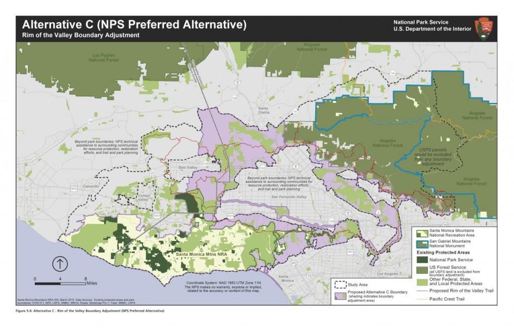
The NPS Preferred Alternative

The National Park Service (NPS) today released the findings of the Rim of the Valley (ROTV) study, including a draft Environmental Impact Report and Proposed Alternatives. The study has been underway since 2010. CORBA has commented on previous phases of the study and has also encouraged our members and the mountain biking community to do so.

The NPS has developed five alternatives for the public to comment upon. Their preferred alternative expands the boundary of the Santa Monica Mountains National Recreation Area (SMMNRA) to include much of the study area, which would allow the NPS to provide technical assistance to other land managers within the NRA.  Other alternatives include a “no action” alternative, meaning that nothing will change, a Conservation Partnership alternative, and a boundary expansion plus conservation partnership alternative.  A fifth alternative, which would have only provided planning assistance for a Rim of the Valley trail, was rejected as it didn’t meet the objectives of the study.

None of the proposed alternatives would affect or include any Angeles National Forest or San Gabriel Mountains National Monument, which would remain under the management of the Forest Service. All alternatives (except the “no action” alternative) include the conceptual Rim of the Valley Trail, as originally envisioned by Marge Feinberg in her 1976 Masters thesis.

CORBA will be analyzing the study’s findings and will report back. Comments must be submitted before June 30, 2015.  An executive summary can be found here. The comprehensive set of related documents and maps, and a comment submission form can be found on the NPS Park Planning web site, while a more user-friendly overview of the process can be found at http://www.nps.gov/pwro/rimofthevalley/index.htm

The NPS is hosting six public meetings between April 21, 2015 and June 2, 2015 to discuss the findings and alternatives presented in the draft study report. We invite and encourage all CORBA members and supporters to attend one of the public meetings. For those unable to attend, we’ll post a full report after the first meeting.

Online/Virtual Public Meeting:

Tuesday, April 21, 2015 12:30 p.m.(PDT)/ 3:30 p.m.(EDT) (WebEx Connect Time)

Please check-in early as there could be some software downloads that you may need to install to participate. The meeting presentation will start promptly at 1:00 pm PDT/4:00 pm EDT.

Click here for instructions on how to participate in the online meeting.

Local Public Meetings Schedule:

Monday, May 4, 2015, 7–9 pm
La Crescenta Public Library, Community Room
2809 Foothill Blvd.
La Crescenta, CA 91214

Tuesday, May 5, 2015, 7–9 pm
William S. Hart Regional Park, Hart Hall
24151 Newhall Avenue
Newhall, CA 91321

Wednesday, May 6,2015, 7–9 pm
Conejo Recreation and Parks District
Community Room
403 West Hillcrest Dr.
Thousand Oaks, CA 91360

Thursday, May 21, 2015, 7–9 pm
Mason Recreation Center
10500 Mason Ave.
Chatsworth, CA 91311

Tuesday, June 2, 2015, 3-5 pm*
El Pueblo de Los Angeles
Hellman-Quon Building
130 Paseo de la Plaza
Los Angeles CA 90012

LA County: Santa Susana Mountains Trails Master Plan Update

Wednesday, March 12th, 2014
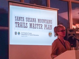
Santa Susana Mountains Trail Master Plan Meeting

Kathline King introduces the SSMTMP

At last weeks second public meeting on the Santa Susana Mountains Trails Master Plan, the County presented a comprehensive map showing their planned trails, the existing trails, and the relevant delineations of private, public and utility lands. While public comments were made, they weren’t being recorded.

CORBA would like to express our sincere thanks and gratitude to L.A. County Parks and Recreation Planning Division staff for moving this trail plan forward, and to Supervisor Antonovich for his support of the process. CORBA whole-heartedly supports project, the process, and the deliverables (maps) presented at the meeting last week.

In looking at the final draft map, we were pleased to see that the agency had listened to the prior comments asking to expand the study area so that true connectivity between disparate open spaces and existing trails could be explored more thoroughly and with a more regional view.

From our cursory review of the maps presented at the meeting, we can say that the work that has gone into this planning effort has been very much worthwhile. We feel the document is a great step towards achieving the stated goals of identifying missing links, providing connectivity between existing trails, open spaces and jurisdictions, and recognizing the value of some of the existing non-system trails. We feel the eventual implementation of the plan will increase both the quality, quantity, and variety of recreational experiences the community so badly needs.

We are also sensitive to the concerns of private property owners who expressed feelings that they hadn’t been heard. However, we also feel that many of their concerns arose from an incomplete understanding of the goals of this planning process. In some cases, it seemed their negative experiences with other neighboring public land managers have elevated their concerns about dealing with the County. We hope that as the plan is implemented and negotiations take place with private land owners (and the neighboring public land managers), their fears can be allayed and mutually beneficial compromises reached for the benefit of the entire trail user community and the public-at-large.

The County’s policy favoring shared-use trails including bicycles is very important to us as a trail advocacy group comprised of bicyclists. We know that there are several places where proposed County trails will connect to trails in City of Los Angeles parks such as O’Melveny and Limekiln Canyon. On these City trails bicycles are presently prohibited. It is our hope that the County and City can come to a compromise that would allow bicycles to connect legally to the proposed County trails/trailheads that are only accessible through City property and trails.

Since this Trail Master Plan will be incorporated into the County General Plan, we feel it would also be worth coordinating proposed trailheads with the 2012 L.A. County Bicycle Master Plan. Having trailheads accessible by bicycle-friendly infrastructure such as Class II Bike lanes is good for encouragement, makes them more accessible to non-drivers, and helps reduce vehicular traffic to trailheads.

CORBA is at present in full support of the plan. It will be presented to the County Rec and Parks Commission later in the year, and subsequently to the L.A. County Board of Supervisors for adoption.

Update March 16, 2014: The plan will be presented to the Planning Commission on March 26, 2014. Meeting starts at 9 am at the Hall of Records Room 150, 320 W. Temple Street, Los Angeles, California 90012. The Parks and Recreation element is agenda item #6.i.

The Trail Master Plan map and powerpoint presentation are available on the County’s web site.

Update, March 26, 2014: The LA County Regional Planning Commission held their hearing on the draft plan today. Steve Messer, Jim Hasenauer, Ken Raleigh and Tony Arnold all testified in support of the plan. One private landowner, and five equestrian representatives also testified in support of the plan, all of them mentioning multi-use trails. Nobody spoke against the plan. Other elements of the County General Plan were also presented to the Commission, who held the matter over until their next meeting in April. We are confident the Planning Commission will approve the plan, which will then go before the Board Of Supervisors later in the year.

LA County’s Draft Santa Susana Mountains Trail Plan

Wednesday, February 12th, 2014

2014-03-06-Santa-Susanna-meeting

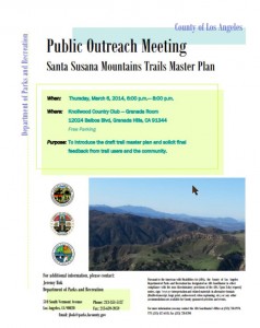
In 2012, CORBA attended public meetings to give input on L.A. County’s Santa Susana Mountains trails master plan. The County has taken the input we and many others gave, and will present their draft Trail Master Plan at a public meeting on March 6 in Granada Hills. They will also seek additional feedback from the trail user community.

The area under consideration for this trails master plan included the unincorporated open space north of Chatsworth, up to the crest of the Santa Susana Mountains. In our comments, and many others submitted by the public, we urged that the project area be expanded north to the LA County border, and east to incorporate the entire northern range of the San Fernando Valley.

The County will present the draft trail master plan at:

Thursday, March 6, 2014, 6:00 p.m. – 8:00 p.m. 
Knollwood Country Club,
Granada Room
12024 Balboa Blvd, 
Granada Hills, CA 91344
Parking is free. 


 Home

About

Membership

Info

Galleries

  Visit CORBA on Twitter!   Visit CORBA on Facebook!

 Site-Map

Activities

Blog & News

Calendar

Buy Stuff


Copyright 1987-2020 CORBA. All Rights Reserved. Privacy Policy