Archive for the ‘Regions’ Category

COSCA Spring Trailwork Report

Monday, March 29th, 2010
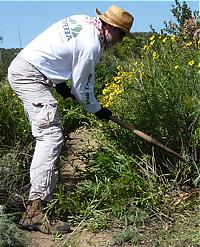
Clearing out overgrown brush

On Saturday, March 27, about two dozen volunteers took part in the Conejo Open Space Conservation Agency’s (COSCA) Spring Trailwork Day. There were a few CORBA volunteers including Board of Directors member Danusia Bennet-Taber as well as volunteers from COSCA and the Santa Monica Mountains Trails Council (SMMTC). The largest contingent were Disney volunteers, who get a free pass to Disneyland for volunteering to help the community for a day. What a great way to encourage and reward volunteerism – our thanks to Disney Corp!     

We worked on the Mountain Creek Trail in Newbury Park. This trail was built last October during the Annual COSCA Trailwork Day by a much larger group of volunteers (see photo gallery). On Saturday, we widened much of the top section, fixed the drainage around a switchback and cleared out a lot of overgrowing brush on the Reino / Potrero Ridge Trail it connects to.     

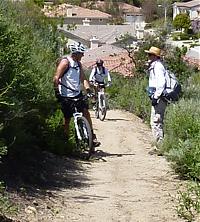
Mountain bikers are quick to ride the reworked trail


On our way back down at the end of the workday, we passed a pair of mountain bikers on their way up. In the few months that this trail has been in existance, it has already become a popular trail to access the multiple singletrack trails in Dos Vientos!     

You can view the photo gallery of Saturday’s work. Many thanks to all the volunteers who came out to help!

Cobb Estate (Sam Merrill Trailhead) Public Meeting

Thursday, March 25th, 2010

This Saturday there’s a hearing about the trail management and “improvements” being considered at Cobb Estate. This is the trailhead for the Sam Merrill Trail, one of the most popular hiking and mountain biking trails in the Angeles Front Country, especially since it has remained open after the station fire.

If you’re available, we’d like to make sure that mountain bikers are present and represented.

LISTENING SESSION
COBB ESTATE

The Los Angeles Ranger District, Angeles National Forest is sponsoring a meeting to discuss the vision for the Cobb Estate

Saturday March 27, 2010, 1 to 3 p.m.
Altadena Community Center
730 E. Altadena Drive
Altadena, CA 91001

– – –

Tuesday, March 23, 2010

Forest Service to hold Cobb Estate “listening session” Sat.*

The U.S. Forest Service will hold a “listening session” this Sat., March 27, from 1-3 PM at the Community Center,730 E. Altadena Dr.

According to District Ranger Michael McIntyre, the Forest Service is looking for public input on the Cobb Estate, the popular hiking area at the end of Lake Ave.

“We’re finding that people are expressing concern or questions about the trail management that we did,” McIntyre said. “I’ve been here now three years, and I’ve heard from a variety of people about what people are doing, and what we did brought up the temperature meter.”

The Forest Service has engaged Outward Bound to do restoration work at the estate, which has included covering over some trails to allow reforestation. However, Outward Bound staff have told Altadenablog that many of their efforts are then undone by some hikers who object to having their favorite trail covered over.

McIntyre said that the choice of which trails to take out of service is an informal process, based on erosion factors or if there are “redundant” trails, i.e. other trails to the same location. “Sounds
like everybody has a favorite trail, and they’re all different trails,” McIntyre said.

Other issues include firelines put up during the Station Fire that have now become trails, signs put up by the Audobon Society that have become graffiti magnets, and directional signs that are more appropriate to a street than a rustic trail.

Saturday’s listening session is the first step in what McIntyre says is a process that may develop a more comprehensive, formalized plan of what to do on the estate.

“Don’t come in with expectations of what’s going to come out of this meeting,” McIntyre said. “I’m very open to collaboration — that’s where you get success.”

Angeles National Forest Update

Wednesday, March 17th, 2010

Tonight CORBA volunteers attended a meeting with ANF Volunteer Coordinator Howard Okamoto. We received some encouraging news from Howard. While the theme of the news is good, nothing is definite, and planned dates may change if we get another round of storms or inclement weather.

Right now the forest closure remains in effect, unchanged since it was first imposed after the fires.  However, the FS hopes to open much of the forest to the public in mid to late April. The area that will definitely remain closed is the Arroyo Seco Canyon, roughly the area from Switzers to JPL, between Brown Mountain and Mt. Lukens.

Highway 2 through that canyon, between Clear Creek and La Canada will likely remain closed for some time as repairs in some of the larger slide areas will entail major construction. However, the Forest is currently accessible via Big Tujunga Canyon. Angeles Forest Highway is open from Big Tujunga to Palmdale; Upper Big Tujunga is open to Shortcut Saddle, and Highway 2 is open between RedBox and Mt. Waterman. The RedBox-Mt. Wilson road is also open.  The roads will be closed any time there is a significant weather event, as the hillsides above the highways are still subject to major slides.

As early as April 1st many picnic and day-use areas may be opened. Trails will most likely be marked as “unmaintained, use at your own risk” before the closure is lifted. Some may be signed as closed if there is significant damage.  In any case, by May we expect to be able to begin surveying damage to trails, and start doing trailwork in the ANF.

We’re looking forward to getting back to our beloved forest. Many trails will have changed significantly and may not be viable without extensive repairs.  CORBA is not alone, and many other groups have an interest in seeing trails restored.

Trailwork has been proceeding on many trails under FS supervision, including the Sam Merrill Trail and Sunset Ridge Trails.  The AC100 crew will start surveying and repairs on El Prieto on April 24. Outward Bound are currently working on the Condor Peak trail and the Stone Canyon trail.

So while this may change depending on the progress of Caltrans road repairs, weather, and other factors, it is encouraging news to say the least. Keep an eye on the CORBA calendar for upcoming trailwork days in the ANF and more announcements.

Report on the 2010 National Bike Summit

Monday, March 15th, 2010

League of American Bicyclists National Bike Summit 2010, March 9-11 in Washington, DC.

by Jim Hasenauer

The Summit was a great experience.  700 + advocates, 75+ of whom were mountain bikers attended.  It was intense and exhausting, very well organized, and extremely motivating.  Days went 8 AM-10 PM. 
 
Here’s the scoop.  Feel free to send questions:
 
Major announcements included:
1.  Google unveiled its new bike routes on Google Maps.  It’s customizable.  (Point and click on the route to change it to your needs.)  Google wants feedback.  If you’ve got it, click on “report a problem” to suggest routes, correct errors, etc.  They’ll check out your comments and route should be changed in 30 days.  Their algorithms tried to avoid traffic congestion and hills
 
2.  Bikes Belong announced a new initiative to bring ordinary cyclists to advocacy.  They’re trying to get one million bike advocates signed up.  Take the pledge at http://www.bikesbelong.org/peopleforbikes
 
3.  Washington DC announced it was building dedicated bike lanes on Pennsylvania Avenue.  They will be open by summer.
 
4  IMBA announced that its 5 year old Memorandum Of Understanding with the National Park Service (NPS) has been renewed for another 5 years.  It promises new pilot projects and a continued commitment to work together.
 
Bikers of all stripes were there and you can’t imagine a more unified, pro-bike context.  Very exciting.
 
Over the two days, we had tons of speakers including Secretary of Transportation Ray LaHood and pro-bike Congressmen Oberstar (MN) and Blumenauer (OR) and great sessions. 
 
On Wednesday, there were panels all day.  I  attended the “IMBA Track”. 
 
The first session was on “Youth  Cycling”.  Mike Eubank reported on Valmont Bike Park in City of Boulder.  The Boulder Mountain Bike Alliance raised 1/2 million dollars and they also got a grant from the CO lottery.  While its still under construction, they’re already doing youth cyclocross, after school rides and weekend recreational riding.  They see it as an extension of Safe Routes to School.  All the programs are free for kids.
 
Dave Secunda has a for profit business Avid4Adventure  that gives kids outdoor experience focusing on mountain biking, rock climbing and kayaking.  He has a contract with 12 school districts for on-campus events and also runs summer camps and family trips.  During peak season he’s got 65 staff.  He says start them young and actually runs programs for pre-schoolers as young as 3, 4 & 5 all the way to high school.
 
Julie Childer spoke about Trips for Kids DC .  Besides the basic TFK, they run a kids category in the Northern Virginia MTB Race Series. They also run learn to ride & learn to race classes and camps and NPS Interpretive Bike Tours of DC monuments.  Their mission:  “Teaching kids to overcome obstacles on trail and in life.”
 
Gary Burlanger spoke about the new National Interscholastic Cycling Association.  They hope to have 50 state high school racing by 2020.  Now there is NorCal, SoCal, Colorado, and Washington.  Wisconsin, Michigan and Texas are coming soon.  Others are in the pipeline.  There is great industry support.  I think hs racing is going to take off.  The vision is student athletes (required 3.0 gpa), inclusivity ( a no bench policy-everyone races), family participation, and attention to safety and risk management.  Their “Coach’s Manual” is a rich “how-to”  ($12. @ www.norcalmtb.org)
 
The Second IMBA session was “Entrepreneurial IMBA”.  Jenn Dice told the sad story of mountain bikers’ relations with the US Forest Service (USFS) in Montana, but it prompted the growth of a 1000 member Montana Mountain Bike Alliance.  She stressed the need of being proactive in developing model trail systems, bike parks, jump parks and pump tracks.
 
Ben Beamer spoke about the Oakridge Ride Center  They began trying to connect out of town forest trails, but public input stressed connecting those trails to and through town as well.  They were able to secure a $400,000 earmark to build the project.  Their goal is to be the MTB Capital of the northwest.
 
Ann, an owner of the Bike Lane in DC spoke about what retailers can do to support advocacy.  MORE, the DC IMBA club now has 300 miles of trail and 32 separate place to ride in and near the metro area.  There are 6000 registered users on the MORE site .
 
Ryan from IMBA pitched the new Chapter Program where clubs will have the opportunity to become IMBA Chapters and will share membership and revenues with IMBA.  IMBA will do the data processing, fulfillment and marketing.  It looks like this year is the big rollout with the World Summit in Augusta, GA the place to get the details https://www.imba.com/summit/2010_World_Summit.html
 
My panel was on the urban transportation/recreation connection.  Jill Van Winkle of IMBA hosted.  I spoke about the LA City Parks process and CORBA’s hard work over several years.  After explaining the current status of the plan, our adversaries’ attempts to thwart us,  and our letter writing campaign to keep mountain bikes in the plan and secure a stronger commitment to mountain biking, I emphasized that all cyclists, regardless of discipline need to work together and support one another.  Most agreed that a mountain bike element in bike plans would become more common.  There are several already including:  Portland, Bend, Flagstaff and Park City.  There are urban mtb trails in Philadelphia, NYC, Seattle, Chattanooga, Albuquerque, Louisville, Bozeman and probably several other places. I emphasized how bikes in urban parks was an important goal for all cyclists and how several of our Summit Political Asks (see below) are intended to improve these opportunities.  Our work was well received
 
Vivian Neal from Oxford Mississippi talked about how their city connected bike paths to mountain bike trail systems outside town.  They’re now building BMX and cyclocross facilities as well. 
 
Several audience members spoke about their town’s accomplishments and/or needs. 
 
This was followed by a plenary session of a panel discussion with several bike advocates and representatives of the Federal Highway Administration talking about reauthorization of the transportation bill.  “Livability” is a key word for the Obama Administration and the Department of Transportation.  Many of our issues are directly related to this goal and the administration is extremely supportive. Highway safety is another important goal and improving the safety of cyclists and pedestrians is high priority.
 
We then met in our state delegations to review talking points and coordinate our meetings.  CA had about 70+ advocates, riders, retailers, industry.  We had the most representatives of any state.  It was terrific.  A committee led by Jim Haggen-Smit of FATRAC and Dorothy Leu of LACBC put together our assignments. 
 
Our ASKS:
 
The League of American Bicyclists and IMBA had six asks for our meetings with congressional staff.
 
1.  Ask the representative to co-sponsor HR 4722 The Active Community Transportation Act of 2010 (Blumenauer).  It would appropriate $400 million for grants to local and regional governments (5-15 million each) to create “active transportation networks”. 
 
2.  Ask the representative to co-sponsor HR 1443  &  S 584  the Complete Streets Act of 2009.  This would require that transportation planners consider all users when planning highway facilities.  20 states including CA already have this as state policy already.  These laws would make it national policy. 
 
3.  Ask the representative to co-sponsor HR 4021 and  S 1156 Safe Routes to School.  Both bills would expand the highly successful Safe Routes program to include eligibility for high schools.  The Senate bill provides higher funding as well. 
 
4.  Ask the representative to co-sponsor HR 3734 The Urban Revitalization and Livable Communities Act which would provide $445 million or urban park and recreation facilities .  The target is facilities for at risk youth in urban areas and these grants would be administered by HUD on a 70-30% federal/local match.  Facilities could include urban trails, bike parks, jump parks etc. 
 
5.  Ask the representative to support full funding for the Land and Water Conservation Fund .  This fund goes back to the 1950’s and is authorized to provide up to $900 million for purchase of parkland and building facilities.  For the last 20 years or so, the money has not been fully appropriated and while its supposed to be split between federal agencies and local agencies, recently only the feds have received funding.  The two bills that would provide full funding each have their own problems.  The Senate Bill S 2747  changes the funding formula which not everyone supports. The House bill HR 3534 is a gigantic, controversial energy bill.  We were instructed to push the principle, not the specific bills. 
 
6.  Protect Public Lands but allow for continued bicycling .  This ask was IMBA’s and there was no particular legislation involved.  We want members of Congress to be alert that when they consider public lands bills, especially those creating Wilderness, they should consider companion designations like National Recreation Areas, National Scenic Areas, National Protection Areas, National Conservation Areas, etc. so that mountain bikers don’t lose trail opportunities. We emphasized our commitment to protecting wild places, but being unfairly hurt when Wilderness is the only designation.
 
On Thursday, I  had three productive meetings with staff from the offices of Congresswoman Linda Sanchez, Henry Waxman and Grace Napolitano.  No staff member made commitments but they were generally supportive on all counts.  Waxman and Napolitano were already co-sponsor of HR 3734.  Napolitano was already a co-sponsor of HR 1443.
 
During the day, Jenn Dice of IMBA testified before the House Subcommittee on Parks, Forests and Public Lands  and was terrific in explaining how a proposed CO Wilderness Bill (HR 4289) would affect mountain bikers .  She explained that we could support 13 of the 34 proposed areas in the bill, but needed adjustments and consideration in the rest.  She took a very high road, “let’s work together” approach.  At the end of the hearing, Congresswoman DeGette the bill’s sponsor offered to meet with IMBA, go for a ride and  even identified 3 places where she was willing to make changes.  All very positive.
 
On Thursday night, the California Bicycle Coalition  had a reception for the CA advocates at the Summit.  They are intent on revitalizing the CBC and raised several thousand dollars at the event.
 
All in all, this was a great event with serious networking, information sharing and the opportunity to really affect pro bike policies on the road and in the dirt. 

Google Maps adds bike routes

Thursday, March 11th, 2010

The mapping tool, added after bicyclists petitioned the company, provides turn-by-turn directions and even figures out routes that help cyclists avoid ‘unreasonable exertion.’

From the Los Angeles Times

After a long wait and more than 50,000 signatures on an online petition, cyclists will be happy to know that Google Inc. has finally added bicycle routes to Google Maps.

In Google Maps, users can now find “Bicycling” in the tool’s “Get Directions” drop-down box. After choosing the option, bikers can input two addresses and find the bike route that will get them to their destination. The mapping tool provides turn-by-turn directions and an estimated travel time.

The new Google Maps bicycling feature is available in 150 U.S. cities, including Los Angeles, San Francisco and New York. The tool features more than 12,000 bike trails. When users look for directions, the company’s mapping algorithm weights trails more heavily than roads for safety reasons. If cities have bicycle lanes, those are also weighted more heavily than roads without them.

One of the more useful features built into the Google Maps bicycling tool is its power-exertion calculation. According to the company, biking directions “compute the effort [bicyclists] will require and the speed [they will] achieve while going uphill.” Based on those calculations, the tool provides bicyclists with a route that eliminates areas that would require “an unreasonable degree of exertion.”

Google said its tool even keeps bicyclists away from busy intersections and areas where bicyclists would need to brake too often.

The Google Maps bicycling tool is in beta testing, which means it might have some bugs. Google plans to add more routes and trails in coming months.

Support Rails to Trails: Act would improve trail, walking and biking networks around the country

Wednesday, March 3rd, 2010

“Active Community Transportation Act of 2010” Introduced in the U.S. House of Representatives

From Rails-to-Trails Conservancy

Please Speak Up for Critical Legislation for Trails, Walking and Bicycling

After years of organizing supporters around the country, Rails-to-Trails Conservancy (RTC) is excited to announce that on Tuesday, March 2, 2010, U.S. Rep. Earl Blumenauer (Ore.) introduced H.R. 4722, the “Active Community Transportation Act of 2010” (ACT Act), on the floor of the House of Representatives!

The ACT Act is the direct result of Rails-to-Trails Conservancy’s (RTC) Campaign for Active Transportation. The Act would create a $2 billion program to fund dozens of communities around the country to improve their trail, walking and biking networks. If this bill is enacted, communities around the country will receive the resources to better allow Americans to walk and bike to the places you live, work, play, shop and learn.

Please encourage your representative to co-sponsor this very important legislation by filling in this petition.

NOTE: The following forward-thinking representatives have already signed on in support of the ACT Act:

  • Earl Blumenauer (Ore.)
  • Michael Capuano (Mass.)
  • Russ Carnahan (Mo.)
  • Steve Cohen (Tenn.)
  • Bob Filner (Cal.)
  • Daniel Lipinski (Ill.)
  • James Moran (Va.)

If your representative is one of the above seven individuals, instead of taking action below, please send a note thanking your representative for already supporting this legislation, and encourage him to continue pushing his colleagues for more support.

Don’t know who your representative is? Use the zip-code tool in the upper-left corner of www.house.gov—it’s easy!

Thank you.

Mountain Biking Grew 10.2% in 2008

Wednesday, December 2nd, 2009

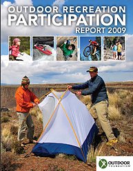
The annual Outdoor Recreation Participation Report looks at year-over-year trends in various outdoor sports, based on the percentage of the population who participate in outdoor recreation in some form. Released earlier this year by the Outdoor Industry Foundation, the report shows a 10.2% increase in mountain biking from 2007 to 2008. Nationwide, the study reports 7,592,000 people who rode a mountain bike.

American’s most frequent outdoor activities were running (trail and pavement) with cycling (road, mountain and BMX) coming in second.  More people participated in outdoor activities than team sports. 15% of Americans rode a bike while 9% played basketball, 7% played football, 6% played soccer.

A disturbing downward trend in outdoor activity participation was seen among the youth over the past three years. In 2006 78% of 6 – 12 year-old children did some outdoor activity, but in 2008 only 64% did so. The 13 – 17 year-old group went from 69% participation in 2006 to 61% in 2008. The biggest drop was seen in girls aged 6 – 12, a 19% drop in participation over three years.

However, cycling (including road, bmx and mountain) remained both the “most popular” and “favorite” outdoor activity of the young. Despite the overall decline in outdoor activity participation, mountain biking among the 6 to 17 year-old age group grew by 17.4% over 2007 numbers, with over two million participants in 2008.

In the 18 to 24 year-old group mountain biking was down 23.8%. The biggest reason given was a “lack of time.”  Adult participation in outdoor activities grew from 48% to 53% in the 25 to 44 year-old group, and from 37% to 38% in those over 45 years of age.

Mountain biking is becoming more and more popular. These numbers underscore the need for us continue working towards opening new trails for this growing user group, and to take care of the trails we already have. We must also continue to get more youth involved in mountain biking, and support those who already do.

This study was based on a sampling of over 40,000 households. The complete report is available from the Outdoor Industry Association Foundation.

Sullivan Canyon reopens November 6th

Thursday, November 5th, 2009

from Sharon O’Rourke, Public Affairs Manager, The Gas Company

The Gas Company is pleased to announce it is completing the first phase of it’s planned work in Sullivan Canyon by Friday, November 6, 2009.  The maintenance road has been re-established and 10 pipeline exposures have been covered with protective revetment mats.  The maintenance road now has the articulated concrete mats (revetment mats) in a few areas of the roadway to provide protection and covering for the pipelines.  The public should exercise caution when crossing these areas with the revetment mats.  By November 6th, the construction equipment and vehicles will be removed as well as ending the guard service.Minor work to hydro-seed vegetation in certain areas will start the week of November 16th and last for approximately 2 weeks.  This work will be during weekdays only from 8am – 5pm.  The canyon will remain open to the public while this work is proceeding as cones will be placed and signage will be posted as a safety precaution due to the presence of vehicles and to protect the newly seeded areas.  Occasionally a water truck may be used to water these areas to help the growth of the new plantings.

We want to thank the public for its patience and courtesy while we worked to ensure the safe operation of our pipelines.  The second phase of our project will start next year approximately in the spring to cover the remaining pipeline exposure areas and to finish the planting of vegetation and the sycamore seedlings.

We also wanted to share with you that our security guard, stationed at the northern end of the canyon, observed a small brush fire off of dirt road Mulholland on Friday, Oct. 31st at approximately 11 p.m.  The fire was caused by a mylar balloon (silver metallic balloon) that was loose and touched the power line, creating sparks that set off a small brush fire.  Our guard called 9-1-1 to report the fire which brought an immediate response from the Los Angeles Fire Department’s air and land crews.  The fire was limited to 1/2 acre. We are thankful that this guard was diligent, alert and responded quickly by calling in the Fire Department.

NICA, IMBA forge new alliance for high school cycling

Wednesday, November 4th, 2009

The National Interscholastic Cycling Association (NICA) and the International Mountain Bicycling Association (IMBA) have recently signed a partnership agreement which states that IMBA and NICA will work together to cross-promote their efforts and engage the broad cycling community.

NICA executive director Matt Fritzinger said, “We are very pleased to formalize our partnership with IMBA — the continued growth of high school mountain biking depends on trail access.” He added, “Riding bikes is a freedom all youth should enjoy, and parents greatly support their kids riding on trails away from the dangers of traffic. IMBA does an incredible job of working with communities to build and maintain sustainable trail systems that work for all trail users.”

“The success of the Northern and Southern California High School Mountain Bike Leagues has been truly remarkable,” said IMBA executive director Mike Van Abel. “When I learned about the plan to replicate those successes on a national scale under the NICA banner, I hoped IMBA’s club network might become a useful resource,” he added, also noting that the partnership would help expand IMBA’s demographic diversity and compliment existing youth programs such as National Take a Kid Mountain Biking Day.

About NICA and IMBA

The National Interscholastic Cycling Association (NICA) is the National Governing Body for grades 9-12 interscholastic mountain biking. NICA was established 2009 with the support of founding national sponsor, Specialized Bicycle Components, as well as the generous support of the founding sponsor of the SoCal League, Easton Sports Development Foundation II. The aim of NICA is to foster the development of high quality competitive cross-country mountain biking programming for High School aged athletes. NICA provides leadership, governance and program support to promote the development of interscholastic Mountain Biking Leagues throughout the United States.

The International Mountain Bicycling Association (IMBA) is a non-profit educational association whose mission is to create, enhance and preserve great trail experiences for mountain bikers worldwide. Since 1988, IMBA has been bringing out the best in mountain biking by encouraging low-impact riding, volunteer trailwork participation, and cooperation among different trail user groups, grassroots advocacy and innovative trail management solutions.

Report on the San Gabriel Watershed and Mountains Special Resources Study

Thursday, September 3rd, 2009

by Steve Messer 

Last night Hans Keifer, Steve Messer and Jim Hasenauer attended the public comment meeting put on by the National Park Service in Santa Clarita. The following is a summary of the presentation and our thoughts, concerns and feedback on the study. 

History:  

This study was mandated by Congress through a bill introduced by Hilda Solis back in about 2002 and passed in 2003. The study began in 2005, but this is the first much of the public has heard of the process, including me and other CORBA and IMBA volunteers. The study area includes much of the San Gabriel mountains, as well as the San Gabriel Watershed. The watershed includes the San Gabriel River drainage area within the national forest, as well as cities along the river and its watershed such as El Monte, Hacienda Heights, La Habra, Brea, Walnut, West Covina, Baldwin Park, Monrovia, La Verne,  and the Puente-Chino Hills area. See more on the study and the process

Study Area:   (See map to right) 

The goal of the first stage of the study was to determine:  

1. the “Significance” in biological, historical and recreational terms, of the study area.   

 2. the “Suitability” of the area for inclusion in the National Park system. That’s to say that it fills a gap in the National Park system that can’t be filled by anything else… ie. its uniqueness.   

 3. The “Feasibility” of bringing it into the National Park system in some manner.   

So far the study has found that there is Significance worthy of national park protection. The mountains, the biodiversity, the unique geological character, architecture and history all make it significant. 

There is “Suitability” in that there is nothing else quite like it already within the National Park System. 

It was deemed to be infeasible to make any of the study area a National Park. There are too many land owners and land managers, too many private holdings even within the National Forest, and in many respects, would be re-inventing the wheel to start from scratch with what the Forest service has already accomplished in managing the forest. 

However, it would be feasible for the National Parks service to come in and participate in the management and development of the area, in collaboration with the Forest Service and other land managers in the study area. 

Of particular concern to us, as mountain bikers, is the continued access to the trails to which we have access, the possibility of new trails being built, and to avoid any further wilderness designations. 

The final goal of the study is to present to congress a report on the Significance, Suitability and Feasibility of the area, and make a final recommendation as to the most effective and efficient way for the NPS to be involved in the management of the San Gabriel Mountains and San Gabriel River watershed. 

What is not covered at this stage of the study is what happens after the study is complete.  

 Once the final recommendation is made, it would then be up to congress to decide what to do with the recommendation. Of particular note is that Hilda Solis is now Labor Secretary, and is no longer involved in the committee that would be receiving the results of the study she helped start. The recommendation may linger on a shelf and never be implemented, or it may get picked up, brought to committee, a further recommendation made to the full house, and then may or may not pass. 

This introduces some concerns. Alternative A and Alternative C both have the largest federal presence, and both would require an act of Congress to implement. Whenever an act of congress is proposed, it will be debated and most likely amended. Amendments may introduce language to weaken our position as mountain bikers, to introduce more wilderness legislation, or to to pander to certain special interest groups with large lobbying powers. It opens the door for a whole range of uncertainties in the implementation of the plan. 

But that scenario would be a long way off. The study is still (four years along) at a very preliminary stage. They expect to have the draft proposal ready in a year, another round of public meetings and comments, and present their findings to congress in 2011. 

Several times during the presentation and the Q&A group sessions, it was expressed that the NPS would continue to allow the Forest Service to manage the forest, and other land managers would continue to manage their own jurisdictions. From our point of view as mountain bikers, this seems good policy, since the Forest Service has just spent five years or so developing the Forest Management Plan <http://www.fs.fed.us/r5/angeles/projects/ForestPlan.shtml> in which the most productive use of the forest was deemed to be Recreation. It sounded like the Forest Service would be able to continue to implement that plan, which is not at odds with the concept of a “National Recreation Area.” 

Jim, Hans, and myself split up and each joined a different discussion group. Nowhere was there any strong or vocal anti-mountain bike sentiment, and in Jim’s group four of the fifteen people were mountain bikers. My group were all hikers from Santa Clarita who wanted more trails and access from the northern slopes of the San Gabriels, which are greatly under-utilized in comparison to the more populated southern slopes. There was no equestrian presence, but a few in my group said that the equestrians were supportive and would be doing a letter writing campaign. Given the past positions of the Equestrian Trails, Inc. (ETI), their campaign will likely be very anti-mountain bike. 

But this meeting wasn’t really about what people wanted more or less of (trails, signage, interpretive centers, etc) though that is what came up most in the group discussions. It was about how the forest and watershed would be managed, and the alternate proposals for how that partnership would function. Management includes the ability to meet the needs and provide the resources that the public want, something that just isn’t presently happening given the current financial situation of the FS. 85% of their budget presently goes to fire management (well spent at the moment) leaving little for improvements.

To summarize the three alternative plans:


Alternative A
, the forest would get the largest involvement by the NPS, the largest land area that would be covered (most of the Lower Angeles National Forest) and management would come mostly from the National Forest Service with assistance, input, and funding from the NPS. This seems to us, as the better option, with less agencies involved, more land area, and more funding. It incorporates most of the Southern Angeles National Forest, and little outside the forest.  


Alternative B would have the NPS creating a Master Plan for the whole area, San Gabriel mountains, rivers, all of the cities and land managers along the river and into the Chino hills. After that master plan is developed, the NPS would have little involvement, and it would be up to each individual jurisdiction to implement that master plan as a the San Gabriels Parks and Open Space Network. It includes the southern Slopes and the San Gabriel mountains and the river corridors.  
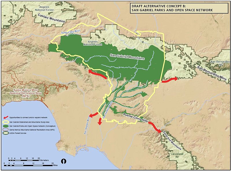
 

Alternative C would have the NPS taking a leadership role and overseeing a partnership between the FS and the many local land managers. The area would include only the San Gabriel watershed and river corridor. This would exclude most of the current southern Angeles National forest.  


There was no mention of new wilderness areas, as this is strictly a study for inclusion in a National recreation area, or Recreational Open Space area, not a wilderness study. Not much was addressed among the group discussions about the lower watershed, including the various cities and the Chino-Puente hills area, though the meetings in El Monte and Diamond bar would have had more involvement in those areas. 

There is a comment period on the current presentation through October 30th. At the above web site, click on “Newsletter 4” then click on the “Comment on Document” link on the left side of the screen. 

They need to hear from as many mountain bikers as possible, to ensure that we are represented as a large and growing user group of the forest. To make comments, here’s my list of my answers and talking points: 

NPS Public Comment Topic Questions: 

1. Is there one alternative concept or idea presented that you think is most valuable in terms of improving recreational opportunities and protecting significant resources? Tell us why you think this idea is valuable. 

The inclusion of the largest land area, Alternative A, would give the most coverage and likely bring the most resources in to manage the national forest.   A combination of Alternatives A & C would provide the most coverage of important natural resources, including both mountain and river protections and opportunities for interpretation.  A combination of A & C would create a strong federal management partnership between the USFS and NPS and a strong recreational identity for the San Gabriel Mountains and watershed.
2. What suggestion do you have for strengthening or improving on the alternative concepts? Do you have an entirely different vision of how the area should be managed? If so, please describe your vision. 

However, the inclusion of the lower watershed portions of Alternatives B and C, which incorporates much of the green belts along the rivers and the Chino-Puente hills, would present the most recreational opportunities to the largest number people. Perhaps some hybrid of these proposals in which the NPS and USFS manage the San Gabriel Mountains portion, and together oversee the partnership outlined in Alternative C as an open space network.   

3. What concerns do you have about the current alternatives? 

Recreation. The most productive use of the forest should continue to be recreation, as outlined in the current Forest Plan, and recreational access should be increased through a more streamlined process for getting new recreational projects approved. Recreational projects should be given administrative and considerational priority over commercial and other proposals, since the most productive and valuable use of the forest has been deemed recreational. We would hope that the NPS could bring in additional staff to more rapidly complete studies required by the NEPA process. These goals would seem to be in line with a National “Recreation” area. 

Mountain bike access. There is a strong need for an area for mountain bike specific trails for this fast growing user group, both to take pressure off existing multi-use trails and minimize disparate user group conflicts. However, this should not be at the expense of continued access to the existing trail network, which are currently enjoyed by many thousands of mountain bikers annually with few conflicts. A mountain-bike specific area or trail network would serve a subset of the mountain bike community whose major preference is technical downhill riding, and whose need has been demonstrated by the continued construction of illegal trails that meet that need within the region. This would remain under Forest Service management within the proposal, and no NPS policy should preclude the fulfilling of this recognized need. 

Protection. Wilderness designations should be actively discouraged from any recommendation, legislation or amendments to legislation, as such designations do not meet the requirements for the best recreational use or protection of wild areas. Other protections are available that allow better management and access to wild areas without compromising biological protection. Other political and user groups are seeing this study and proposal as a way to slip in more wilderness designations. This is contrary to the recreational nature of the forest and not in the best interest of the public as a whole. 

Management. The Forest Service should be allowed to continue to implement its Forest Master Plan, albeit with additional resources and funding provided by the NPS within their shared goals and objectives. They have already invested years of study into the area, and have developed a master plan that at present provides the best guideline for the management and further development of the forest. 

4. What are your thoughts or comments on the study findings (significance, suitability or feasibility)? 

There is no doubt among any who have hiked, mountain biked, soared (hang gliders), ridden horses, off-highway vehicles, rock climbed, or done any geological, biological  or archaeological study, that the area is significant, unique, and worthy of including in the NPS system. 

The biggest concern then becomes the addition of an additional layer of bureaucracy when trying to make improvements in access, recreational opportunities or facilities. Based on information in the presentation, those concerns appear to be minimized in the present proposals. The political manipulation of legislation that may be introduced as a result of the study favoring one user group over another, or one type of biological protection over another, then becomes the major future consideration, and that is largely beyond the scope of the present study. 

Summary and Future: 

 There is nothing presently in the study that would threaten mountain bike access to the Naitonal Forest. In fact, all indications are that the increased funding and NPS administrative assistance, as Alternatives A and C would provide, would be beneficial to all forest user groups. Perhaps some hybrid of the alternatives would be best. The NPS will hopefully determine that from the comments and meetings.

At present, we should keep monitoring the web site <http://www.nps.gov/pwro/sangabriel> for changes and updates. The newsletters (Currently number 4) outline the progress of the study and explain each of the currently proposed alternatives in detail, including the vision, concept, management structure and funding. 

Post your comments to the NPS web site as mentioned previously, and feel free to use what has been provided above or to elaborate or put your own thoughts into words. 

The next round of public meetings will take place once the draft proposal is ready (Q4 2010), and we’ll have the opportunity to make our voices heard again then.