Archive for the ‘Angeles National Forest’ Category

Fire-danger level being raised at Angeles National Forest

Saturday, May 22nd, 2010

ARCADIA, Calif. – The Angeles National Forest fire-danger level will be raised from “Low” to “High” on Monday, May 24, to enhance public awareness that fire-risk conditions are rising with warmer weather and drier local vegetation.

“High” is the third in a six-level, graduated fire-danger rating system, shown in the enclosed graphic. Factors determining the levels include vegetation-moisture levels, weather conditions and available firefighting resources.

Despite the change, there are no new campfire restrictions. Open wood and charcoal fires will still be permitted in approved “developed” campgrounds and picnic areas. Gas and propane-powered stoves and grills are permitted in non-developed areas with a state Campfire Permit.

Forest visitors should check spark arrestors (required year-round) on off-road vehicles, chain saws and other equipment with internal-combustion engines to ensure they are in working order. Drivers in the forest should stay on designated roads and never park on dry brush or grass, to avoid risk of starting a fire.

For more information, please contact Sherry Rollman, public affairs officer; or John D. Wagner, assistant public affairs officer, at (626) 574-5208.

A push to preserve the San Gabriels

Sunday, May 16th, 2010
A proposal would protect more of the mountain range and its rivers.
 
The river ripples cold around his waders as Bill Reeves casts a dry fly onto a pool edged with alders on the bottom of a canyon deep in the San Gabriel Mountains.  

Reeves, 69, who first fished this stretch of the San Gabriel River’s west fork with his father more than half a century ago, was in his element — scanning the eddies for rising wild trout in a wilderness that resurrected childhood memories. 

“I’d be happy if this place stayed just the way it is,” the stout conservationist said. “But with 10 million people living within an hour’s drive, these mountains definitely need more protection.”    

Reeves is a member of San Gabriel Mountains Forever, a campaign that is pushing Rep. David Dreier (R-San Dimas) to fashion a bill that would shield a larger portion of the 655,000-acre range and its free-flowing rivers from pollution and population woes with the strongest federal protections available.    

The goal is to add 30,000 acres to three existing wilderness areas and have 44 miles of San Antonio Creek, the middle fork of Lytle Creek and portions of the San Gabriel River’s east, west and north forks protected under the national Wild and Scenic Rivers Act, which would prohibit new damming.    

Today, only a 7-mile stretch of Piru Creek, in the northern San Gabriel Mountains, is designated as wild and scenic.    

Conservationists fear that time is running out. Encroachment from foothill subdivisions in the San Gabriel Valley and Lancaster, cuts to the U.S. Forest Service budget, arson fires and millions of annual visitors are eroding the qualities that make the mountains special, they say.    

“Our aim with this proposal is to protect the one-third of the Angeles National Forest that is still unspoiled open space,” said John Monsen, regional representative of the Sierra Club, one of several environmental groups in the campaign, including the Wilderness Society and Friends of the River. “The trick is to get it introduced in time for this Congress to vote on it. If it is delayed another year, there is no telling what will happen.”    

Down the mountain (Brian van der Brug / Los Angeles Times)

Hikers follow a trail near the middle fork of Lytle Creek in the Cucamonga Wilderness. "Our aim with this proposal is to protect the one-third of the Angeles National Forest that is still unspoiled open space," said John Monsen, regional representative of the Sierra Club. "The trick is to get it introduced in time for this Congress to vote on it. If it is delayed another year, there is no telling what will happen."

Dreier, whose district includes much of the range, is seeking input and support for the plan from the myriad cities, environmental and recreational organizations, fire departments, flood control agencies and water districts laying claims on the watershed, which provides Los Angeles County with 70% of its open space and roughly 35% of its water.    

As part of an effort to avoid conflict, San Gabriel Mountains Forever has altered proposed wilderness boundary lines to accommodate utility company and water district easements, and has added specific language to its proposal to ensure that the Los Angeles County Fire Department has access to wilderness areas in the event of an emergency.    

Dreier was unavailable for comment. But his legislative director, Alisa Do, said, “the congressman is committed to seeing it through.”    

“But we have to be careful and cautious because this area is prone to wildfires and flooding,” she said. “Any change we make would be permanent, so the congressman continues to do his due diligence to ensure this process is done correctly.”    

So far, nine cities, including Claremont and La Canada-Flintridge, have filed letters and passed resolutions in support of the proposal, which is also backed by dozens of San Gabriel Valley churches.    

Negotiations continue, however, with the Los Angeles County Department of Public Works, which is worried about potential impacts on its ability to operate crucial flood control and reservoir systems.    

Of particular concern is Cogswell Dam, a remote county flood control operation that looms over an 8-mile-long stretch of the San Gabriel River’s west fork proposed for wild and scenic status.    

The operation controls the flow in the stream, which provides some of the best fly fishing in Southern California and helps recharge the metropolitan aquifer in the flatlands below. It also has an easement for the 8-mile-long asphalt lane connecting the dam to Highway 39.    

“We support the conservation effort being proposed by San Gabriel Mountains Forever,” said Mark Pestrella, the county deputy director of public works. “But they have to recognize that we run a very large system that includes man-made dams up there that provide water and safety for millions of people. We want to make sure that we are not giving away rights to some critical future need.”    

Stretching in an oblong mass from Santa Clarita to San Bernardino, the mountains’ wrinkled slopes and lush canyons are also defined by the habitat and wanderings of many rare and endangered species, including Nelson’s bighorn sheep, mountain yellow-legged frogs, Santa Ana suckers and Pacific pond turtles.    

Yet, on a recent weekday, picnic sites and trail heads along Highway 39 north of Azusa were strewn with trash, broken glass and discarded lawn chairs and ice chests. Interpretive signs and boulders as big as billboards were covered with graffiti. Picnickers fished and waded in a stream that has turned the color of coffee because of sediment and ash from the Station Fire, the devastating arson blaze of last year.    

Marty Dumpis, deputy forest supervisor for the U.S. Forest Service, which manages the range, believes the proposal would focus additional attention on the San Gabriels and their need for “more resources and educational programs.”    

As it stands, the financially strapped Forest Service relies on volunteers to help pick up trash, remove graffiti, patrol picnic areas and run conservation and educational programs. Among them are D.D. Trent, a geologist, and Ronald Quinn, a professor of biological sciences at Cal Poly Pomona.    

On a recent weekday, Trent and Quinn led a hike along the middle fork of Lytle Creek, a network of cascading snowmelt, ponds and wetlands rolling out of a rugged canyon thick with sycamores, alders, oak and Douglas fir trees.    

As a botanist, Quinn marveled at the living bluish-green blanket of shrubs collectively known as chaparral — holly-leafed cherry, Indian paintbrush, white sage, chemise, wild onions, manzanita — covering the mountains’ shoulders.    

As a geologist, Trent admired the “restless, adolescent peaks being squeezed upward by a giant vice of tectonic strain. If not for the intensity of the erosion, these would be the tallest mountains in the world.”    

But as occasional weekend hikers in the canyon, they were confounded that a great majority of the people who live only a few minutes away never glimpse its backcountry trails.

San Gabriel Watershed Study Comments Released

Wednesday, April 21st, 2010

Back in September 2009 CORBA representatives attended a series of public hearings on the San Gabriel Watershed and Mountains Special Resources Study.  During those public meetings the NPS outlined possible ways of improving the management of the San Gabriel watershed, as mandated by Congress.

The National Park Service has released their Draft Alternative Concepts Public Outreach Results, including comments sent by CORBA and our members and supporters.  From those results, it is clear that many believed that a hybrid of alternatives A and C would be a viable option. This would provide NPS oversight and funding, and would increase the area served and protected without any apparent adverse impacts on recreational opportunities.  The published results include summaries, and links to all the individual comments received. It does not include NPS responses to any of the comments.

The NPS will now take all the feedback and comments received into consideration as they prepare the draft study report. While mountain bike access to the San Gabriels or the Angeles National Forest is not threatened by anything proposed so far, we want to keep abreast of any developments that affect this treasured natural resource.

MWBA Pancake Breakfast

Tuesday, April 20th, 2010

On Sunday, April 24th, the annual MWBA Pancake Breakfast will be happening at Cobb Estate in the foothills of the Angeles National Forest.

For the past several years, the Pancake Breakfast has been held the same weekend as the Santa Monica Mountains Trail Days, a full-weekend of camping, trailwork and riding at Point Mugu. We’ve always felt it more important to be out getting our hands dirty and working on trails, and CORBA hasn’t been at the pancake breakfast for the past few years.

This year we’ll be able to do both!  A few of the CORBA volunteers will head back from Point Mugu a day early to join in the festivities at Cobb Estate.

CORBA volunteers will be there to talk about trail issues, promote trail stewardship and mountain biking, and to just be a part of the fun. If you’re not a CORBA member, you’ll be able to join on the spot. If you are, you can renew.

Come out to the Pancake Breakfast and show your support for trail stewardship in the area. Now, more than ever, our local trails need it.

See you there!

State Trail Day in the Angeles Forest 4/17/10

Tuesday, April 13th, 2010

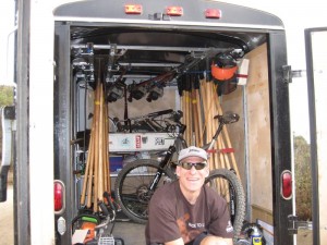
Hans, an OTB rider and the CORBA trail maintenance coordinator, sits on the CORBA trailwork trailer, loaded with tools

Join the CORBA Trail Crew and other trail user groups for a day of trail maintenance.

Meet at 8:00 am at the Wildwood Picnic area.  Bring your own lunch and water.  Sturdy shoes and long pants are required.

Work will be on the Stone Canyon Trail.  This trail goes up to Mount Lukins.

Take Big Tujunga Canyon Road approximately 5 miles north of Ora Vista Street to the Wildwood Picnic area.

For more information contact Hans at trailcrew@corbamtb.com

Arroyo Seco Assessment of Health

Sunday, April 4th, 2010

For many mountain bikers, hikers and equestrians, the Arroyo Seco is the jumping off point for trail systems behind JPL, which have been closed to the public since the Station Fire. Well-known trails such as the Gabrieleno National Recreation Trail pass through the Arroyo Seco canyon. There are plans being considered for the Hahamongna Watershed Park, at the mouth of the canyon, for development, soccer fields, and a bike path.

The Los Angeles & San Gabriel Rivers Watershed Council invites you to attend a workshop on April 6th 1pm-5pm at La Casita del Arroyo. The Watershed Council is developing an indicator-driven tool for assessing the social, ecological and economic health of Southern California Watersheds. We are partnering with researchers from USC, UCLA, UC Davis, the US Forest Service and the California Office of Environmental Health and Hazard Assessment.

The Arroyo Seco Watershed was chosen by our project team and technical advisory committee as the location for a pilot application of the assessment tool. We are inviting stakeholders in the Arroyo Seco to comment on the indicators of health that have been selected. The workshop will include a presentation of the research to date, and break-out sessions where attendees can provide feedback. Please RSVP at this link:

http://www.lasgrwc.org/ap6

Questions can be directed to Mike Antos (mike@lasgrwc.org,  213-229-9954). This project is funded by the CA Department of Water Resources. We’d like to thank the City of Pasadena, Department of Public Works, Parks & Natural Resources Division, for providing the meeting location and for their support and assistance.

State Trail Day in the Angeles Forest 4/17/10

Wednesday, March 31st, 2010

Join the CORBA Trail Crew and other trail user groups for a day of trail maintenance.

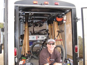
Hans, an OTB rider and the CORBA trail maintenance coordinator, sits on the CORBA trailwork trailer, loaded with tools

Meet at 8:00 am at the Wildwood Picnic area.  Bring your own lunch and water.  Sturdy shoes and long pants are required.

Work will be on the Stone Canyon Trail.  This trail goes up to Mount Lukins.

Take Big Tujunga Canyon Road approximately 5 miles north of Ora Vista Street to the Wildwood Picnic area.

For more information contact Hans at trailcrew@corbamtb.com

Cobb Estate (Sam Merrill Trailhead) Public Meeting

Thursday, March 25th, 2010

This Saturday there’s a hearing about the trail management and “improvements” being considered at Cobb Estate. This is the trailhead for the Sam Merrill Trail, one of the most popular hiking and mountain biking trails in the Angeles Front Country, especially since it has remained open after the station fire.

If you’re available, we’d like to make sure that mountain bikers are present and represented.

LISTENING SESSION
COBB ESTATE

The Los Angeles Ranger District, Angeles National Forest is sponsoring a meeting to discuss the vision for the Cobb Estate

Saturday March 27, 2010, 1 to 3 p.m.
Altadena Community Center
730 E. Altadena Drive
Altadena, CA 91001

– – –

Tuesday, March 23, 2010

Forest Service to hold Cobb Estate “listening session” Sat.*

The U.S. Forest Service will hold a “listening session” this Sat., March 27, from 1-3 PM at the Community Center,730 E. Altadena Dr.

According to District Ranger Michael McIntyre, the Forest Service is looking for public input on the Cobb Estate, the popular hiking area at the end of Lake Ave.

“We’re finding that people are expressing concern or questions about the trail management that we did,” McIntyre said. “I’ve been here now three years, and I’ve heard from a variety of people about what people are doing, and what we did brought up the temperature meter.”

The Forest Service has engaged Outward Bound to do restoration work at the estate, which has included covering over some trails to allow reforestation. However, Outward Bound staff have told Altadenablog that many of their efforts are then undone by some hikers who object to having their favorite trail covered over.

McIntyre said that the choice of which trails to take out of service is an informal process, based on erosion factors or if there are “redundant” trails, i.e. other trails to the same location. “Sounds
like everybody has a favorite trail, and they’re all different trails,” McIntyre said.

Other issues include firelines put up during the Station Fire that have now become trails, signs put up by the Audobon Society that have become graffiti magnets, and directional signs that are more appropriate to a street than a rustic trail.

Saturday’s listening session is the first step in what McIntyre says is a process that may develop a more comprehensive, formalized plan of what to do on the estate.

“Don’t come in with expectations of what’s going to come out of this meeting,” McIntyre said. “I’m very open to collaboration — that’s where you get success.”

Angeles National Forest Update

Wednesday, March 17th, 2010

Tonight CORBA volunteers attended a meeting with ANF Volunteer Coordinator Howard Okamoto. We received some encouraging news from Howard. While the theme of the news is good, nothing is definite, and planned dates may change if we get another round of storms or inclement weather.

Right now the forest closure remains in effect, unchanged since it was first imposed after the fires.  However, the FS hopes to open much of the forest to the public in mid to late April. The area that will definitely remain closed is the Arroyo Seco Canyon, roughly the area from Switzers to JPL, between Brown Mountain and Mt. Lukens.

Highway 2 through that canyon, between Clear Creek and La Canada will likely remain closed for some time as repairs in some of the larger slide areas will entail major construction. However, the Forest is currently accessible via Big Tujunga Canyon. Angeles Forest Highway is open from Big Tujunga to Palmdale; Upper Big Tujunga is open to Shortcut Saddle, and Highway 2 is open between RedBox and Mt. Waterman. The RedBox-Mt. Wilson road is also open.  The roads will be closed any time there is a significant weather event, as the hillsides above the highways are still subject to major slides.

As early as April 1st many picnic and day-use areas may be opened. Trails will most likely be marked as “unmaintained, use at your own risk” before the closure is lifted. Some may be signed as closed if there is significant damage.  In any case, by May we expect to be able to begin surveying damage to trails, and start doing trailwork in the ANF.

We’re looking forward to getting back to our beloved forest. Many trails will have changed significantly and may not be viable without extensive repairs.  CORBA is not alone, and many other groups have an interest in seeing trails restored.

Trailwork has been proceeding on many trails under FS supervision, including the Sam Merrill Trail and Sunset Ridge Trails.  The AC100 crew will start surveying and repairs on El Prieto on April 24. Outward Bound are currently working on the Condor Peak trail and the Stone Canyon trail.

So while this may change depending on the progress of Caltrans road repairs, weather, and other factors, it is encouraging news to say the least. Keep an eye on the CORBA calendar for upcoming trailwork days in the ANF and more announcements.

Report on the San Gabriel Watershed and Mountains Special Resources Study

Thursday, September 3rd, 2009

by Steve Messer 

Last night Hans Keifer, Steve Messer and Jim Hasenauer attended the public comment meeting put on by the National Park Service in Santa Clarita. The following is a summary of the presentation and our thoughts, concerns and feedback on the study. 

History:  

This study was mandated by Congress through a bill introduced by Hilda Solis back in about 2002 and passed in 2003. The study began in 2005, but this is the first much of the public has heard of the process, including me and other CORBA and IMBA volunteers. The study area includes much of the San Gabriel mountains, as well as the San Gabriel Watershed. The watershed includes the San Gabriel River drainage area within the national forest, as well as cities along the river and its watershed such as El Monte, Hacienda Heights, La Habra, Brea, Walnut, West Covina, Baldwin Park, Monrovia, La Verne,  and the Puente-Chino Hills area. See more on the study and the process

Study Area:   (See map to right) 

The goal of the first stage of the study was to determine:  

1. the “Significance” in biological, historical and recreational terms, of the study area.   

 2. the “Suitability” of the area for inclusion in the National Park system. That’s to say that it fills a gap in the National Park system that can’t be filled by anything else… ie. its uniqueness.   

 3. The “Feasibility” of bringing it into the National Park system in some manner.   

So far the study has found that there is Significance worthy of national park protection. The mountains, the biodiversity, the unique geological character, architecture and history all make it significant. 

There is “Suitability” in that there is nothing else quite like it already within the National Park System. 

It was deemed to be infeasible to make any of the study area a National Park. There are too many land owners and land managers, too many private holdings even within the National Forest, and in many respects, would be re-inventing the wheel to start from scratch with what the Forest service has already accomplished in managing the forest. 

However, it would be feasible for the National Parks service to come in and participate in the management and development of the area, in collaboration with the Forest Service and other land managers in the study area. 

Of particular concern to us, as mountain bikers, is the continued access to the trails to which we have access, the possibility of new trails being built, and to avoid any further wilderness designations. 

The final goal of the study is to present to congress a report on the Significance, Suitability and Feasibility of the area, and make a final recommendation as to the most effective and efficient way for the NPS to be involved in the management of the San Gabriel Mountains and San Gabriel River watershed. 

What is not covered at this stage of the study is what happens after the study is complete.  

 Once the final recommendation is made, it would then be up to congress to decide what to do with the recommendation. Of particular note is that Hilda Solis is now Labor Secretary, and is no longer involved in the committee that would be receiving the results of the study she helped start. The recommendation may linger on a shelf and never be implemented, or it may get picked up, brought to committee, a further recommendation made to the full house, and then may or may not pass. 

This introduces some concerns. Alternative A and Alternative C both have the largest federal presence, and both would require an act of Congress to implement. Whenever an act of congress is proposed, it will be debated and most likely amended. Amendments may introduce language to weaken our position as mountain bikers, to introduce more wilderness legislation, or to to pander to certain special interest groups with large lobbying powers. It opens the door for a whole range of uncertainties in the implementation of the plan. 

But that scenario would be a long way off. The study is still (four years along) at a very preliminary stage. They expect to have the draft proposal ready in a year, another round of public meetings and comments, and present their findings to congress in 2011. 

Several times during the presentation and the Q&A group sessions, it was expressed that the NPS would continue to allow the Forest Service to manage the forest, and other land managers would continue to manage their own jurisdictions. From our point of view as mountain bikers, this seems good policy, since the Forest Service has just spent five years or so developing the Forest Management Plan <http://www.fs.fed.us/r5/angeles/projects/ForestPlan.shtml> in which the most productive use of the forest was deemed to be Recreation. It sounded like the Forest Service would be able to continue to implement that plan, which is not at odds with the concept of a “National Recreation Area.” 

Jim, Hans, and myself split up and each joined a different discussion group. Nowhere was there any strong or vocal anti-mountain bike sentiment, and in Jim’s group four of the fifteen people were mountain bikers. My group were all hikers from Santa Clarita who wanted more trails and access from the northern slopes of the San Gabriels, which are greatly under-utilized in comparison to the more populated southern slopes. There was no equestrian presence, but a few in my group said that the equestrians were supportive and would be doing a letter writing campaign. Given the past positions of the Equestrian Trails, Inc. (ETI), their campaign will likely be very anti-mountain bike. 

But this meeting wasn’t really about what people wanted more or less of (trails, signage, interpretive centers, etc) though that is what came up most in the group discussions. It was about how the forest and watershed would be managed, and the alternate proposals for how that partnership would function. Management includes the ability to meet the needs and provide the resources that the public want, something that just isn’t presently happening given the current financial situation of the FS. 85% of their budget presently goes to fire management (well spent at the moment) leaving little for improvements.

To summarize the three alternative plans:


Alternative A
, the forest would get the largest involvement by the NPS, the largest land area that would be covered (most of the Lower Angeles National Forest) and management would come mostly from the National Forest Service with assistance, input, and funding from the NPS. This seems to us, as the better option, with less agencies involved, more land area, and more funding. It incorporates most of the Southern Angeles National Forest, and little outside the forest.  


Alternative B would have the NPS creating a Master Plan for the whole area, San Gabriel mountains, rivers, all of the cities and land managers along the river and into the Chino hills. After that master plan is developed, the NPS would have little involvement, and it would be up to each individual jurisdiction to implement that master plan as a the San Gabriels Parks and Open Space Network. It includes the southern Slopes and the San Gabriel mountains and the river corridors.  
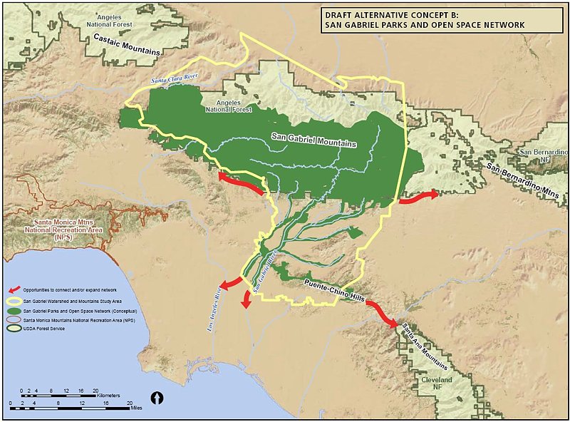
 

Alternative C would have the NPS taking a leadership role and overseeing a partnership between the FS and the many local land managers. The area would include only the San Gabriel watershed and river corridor. This would exclude most of the current southern Angeles National forest.  


There was no mention of new wilderness areas, as this is strictly a study for inclusion in a National recreation area, or Recreational Open Space area, not a wilderness study. Not much was addressed among the group discussions about the lower watershed, including the various cities and the Chino-Puente hills area, though the meetings in El Monte and Diamond bar would have had more involvement in those areas. 

There is a comment period on the current presentation through October 30th. At the above web site, click on “Newsletter 4” then click on the “Comment on Document” link on the left side of the screen. 

They need to hear from as many mountain bikers as possible, to ensure that we are represented as a large and growing user group of the forest. To make comments, here’s my list of my answers and talking points: 

NPS Public Comment Topic Questions: 

1. Is there one alternative concept or idea presented that you think is most valuable in terms of improving recreational opportunities and protecting significant resources? Tell us why you think this idea is valuable. 

The inclusion of the largest land area, Alternative A, would give the most coverage and likely bring the most resources in to manage the national forest.   A combination of Alternatives A & C would provide the most coverage of important natural resources, including both mountain and river protections and opportunities for interpretation.  A combination of A & C would create a strong federal management partnership between the USFS and NPS and a strong recreational identity for the San Gabriel Mountains and watershed.
2. What suggestion do you have for strengthening or improving on the alternative concepts? Do you have an entirely different vision of how the area should be managed? If so, please describe your vision. 

However, the inclusion of the lower watershed portions of Alternatives B and C, which incorporates much of the green belts along the rivers and the Chino-Puente hills, would present the most recreational opportunities to the largest number people. Perhaps some hybrid of these proposals in which the NPS and USFS manage the San Gabriel Mountains portion, and together oversee the partnership outlined in Alternative C as an open space network.   

3. What concerns do you have about the current alternatives? 

Recreation. The most productive use of the forest should continue to be recreation, as outlined in the current Forest Plan, and recreational access should be increased through a more streamlined process for getting new recreational projects approved. Recreational projects should be given administrative and considerational priority over commercial and other proposals, since the most productive and valuable use of the forest has been deemed recreational. We would hope that the NPS could bring in additional staff to more rapidly complete studies required by the NEPA process. These goals would seem to be in line with a National “Recreation” area. 

Mountain bike access. There is a strong need for an area for mountain bike specific trails for this fast growing user group, both to take pressure off existing multi-use trails and minimize disparate user group conflicts. However, this should not be at the expense of continued access to the existing trail network, which are currently enjoyed by many thousands of mountain bikers annually with few conflicts. A mountain-bike specific area or trail network would serve a subset of the mountain bike community whose major preference is technical downhill riding, and whose need has been demonstrated by the continued construction of illegal trails that meet that need within the region. This would remain under Forest Service management within the proposal, and no NPS policy should preclude the fulfilling of this recognized need. 

Protection. Wilderness designations should be actively discouraged from any recommendation, legislation or amendments to legislation, as such designations do not meet the requirements for the best recreational use or protection of wild areas. Other protections are available that allow better management and access to wild areas without compromising biological protection. Other political and user groups are seeing this study and proposal as a way to slip in more wilderness designations. This is contrary to the recreational nature of the forest and not in the best interest of the public as a whole. 

Management. The Forest Service should be allowed to continue to implement its Forest Master Plan, albeit with additional resources and funding provided by the NPS within their shared goals and objectives. They have already invested years of study into the area, and have developed a master plan that at present provides the best guideline for the management and further development of the forest. 

4. What are your thoughts or comments on the study findings (significance, suitability or feasibility)? 

There is no doubt among any who have hiked, mountain biked, soared (hang gliders), ridden horses, off-highway vehicles, rock climbed, or done any geological, biological  or archaeological study, that the area is significant, unique, and worthy of including in the NPS system. 

The biggest concern then becomes the addition of an additional layer of bureaucracy when trying to make improvements in access, recreational opportunities or facilities. Based on information in the presentation, those concerns appear to be minimized in the present proposals. The political manipulation of legislation that may be introduced as a result of the study favoring one user group over another, or one type of biological protection over another, then becomes the major future consideration, and that is largely beyond the scope of the present study. 

Summary and Future: 

 There is nothing presently in the study that would threaten mountain bike access to the Naitonal Forest. In fact, all indications are that the increased funding and NPS administrative assistance, as Alternatives A and C would provide, would be beneficial to all forest user groups. Perhaps some hybrid of the alternatives would be best. The NPS will hopefully determine that from the comments and meetings.

At present, we should keep monitoring the web site <http://www.nps.gov/pwro/sangabriel> for changes and updates. The newsletters (Currently number 4) outline the progress of the study and explain each of the currently proposed alternatives in detail, including the vision, concept, management structure and funding. 

Post your comments to the NPS web site as mentioned previously, and feel free to use what has been provided above or to elaborate or put your own thoughts into words. 

The next round of public meetings will take place once the draft proposal is ready (Q4 2010), and we’ll have the opportunity to make our voices heard again then.