Archive for the ‘Trail Access’ Category

Glendale Park Planning Meeting – Sep 26

Friday, September 18th, 2015

2015 Glendale Parks Meeting
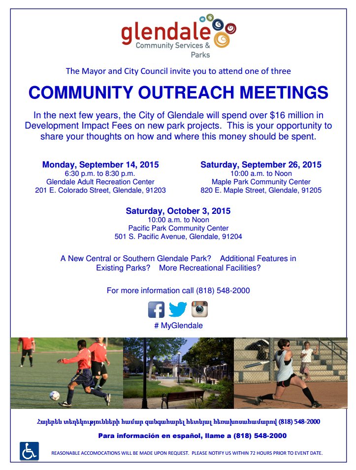
The City of Glendale is growing. The increase in development of the downtown area has provided the City some funds for parks, and they are asking the public how that money should be spent.

We have some ideas, and you might too. The City wants to hear from us on Saturday, September 26, 10 a.m. – noon at the Maple Park Community Center, 820 E. Maple Street, Glendale, 91205. A third meeting will take place at the Pacific Park Community Center on Saturday, October 3, 10 a.m. – noon.

In 2008, CORBA successfully lobbied the City of Glendale to include a Bicycle Skills Park and Bike-Only downhill trail in their Trail Master Plan. In 2012, CORBA and the Los Angeles County Bicycle Coalition advocated for a bicycle skills park in their Safe and Healthy Streets Plan (within Chapter 3, Encouragement, and Chapter 2, Education components of that plan).

We started a Glendale Bike Park petition in 2011 that gathered over 500 signatures online and several hundred more on paper. That online petition is still live and available to be signed at: http://www.ipetitions.com/petition/glendale_bike_skills_park/. This pre-dates our current Los Angeles Bike Park Collective Petition which has over 1800 signatures calling for bike parks in the greater Los Angeles area.

in 2011 CORBA’s then Vice President Steve Messer and former high school mountain biking Coach Mauricio Barba testified before the Glendale Parks Commission to propose a new bike park. Not long after, the great recession forced the City to cut back and put many programs on hold, including our Bike Park proposal.

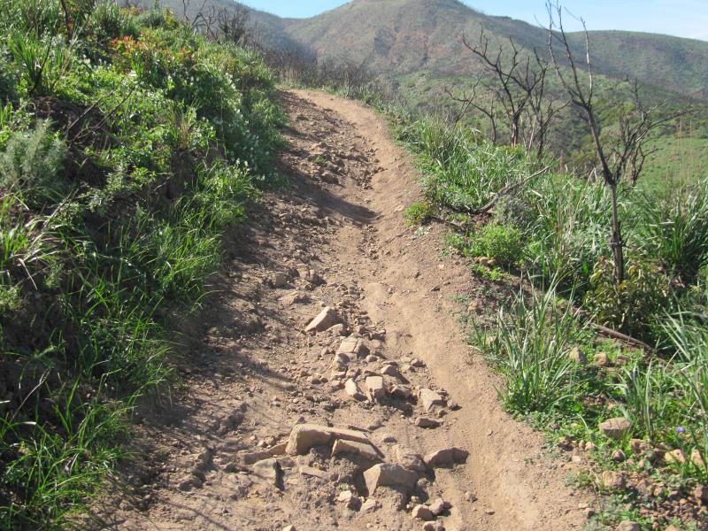
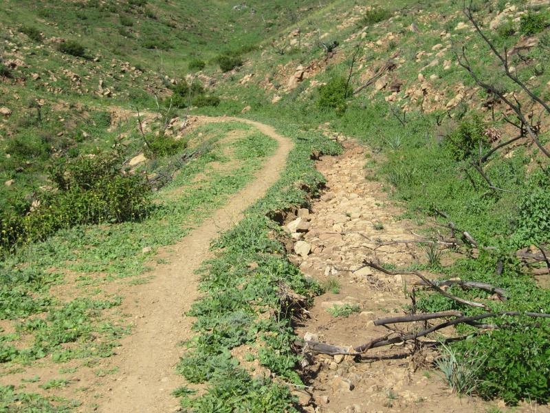
Earlier, in 2007 CORBA gave significant input to the City of Glendale Trail Master Plan. We proposed, and the City adopted plans for a number of new trails. Since the opening of the highly successful Catalina Verdugo trail, we believe the City is ready for a beginner-friendly multi-use singletrack trail connection from Brand Library to Las Flores Motorway and South Beaudry Motorway. Such a trail would connect these popular fire road routes and make much more interesting loop ride or hikes possible, at more beginner-friendly grades than existing fire roads.

The funds available to the City of Glendale are primarily allocated for the downtown and south Glendale areas, but there is an opportunity for some of those funds be allocated to projects that have a city-wide benefit. Come on out and ask Glendale for the Bike Skills Park, and new trails that will benefit the entire community, and/or a smaller Community Pump Track for South Glendale, or perhaps even the proposed Space 134 project, where you can currently vote for a “Bike Station.”

Castaic Area Trail Master Plan Public Meetings

Tuesday, August 18th, 2015

Castaic Trail PlanWith proposed developments at Tapia Canyon and our pending proposal for a bike park at Castaic Lake State Recreation Area, there are some changes coming to trails and bike access in the Castaic Area. We’ve long known that the trails of Tapia Canyon, in particular, would be at risk once the developers move forward with their construction plans. We’ve had several meetings with the developers who seem willing to work with us to preserve some trails in the area.

In response to the public’s need for future planning, 5th District Supervisor Michael Antonovich has authorized the development of the Castaic Area Multi-Use Trail Plan.  The County will survey existing trails, proposed developments, desired trail connections, and gauge future trail needs to support a growing population. This will be a similar process to the Santa Susana Mountains Trail Master Plan, a process in which we participated from April 2012 until it’s completion last year.

The first general public meeting is scheduled for Thursday, August 20th at 6:30 p.m., at the Los Angeles County Castaic Public Library, 27971 Sloan Canyon Road, Val Verde, CA 91384.  This meeting will be followed by three user-group specific meetings for mountain bikers, equestrians, and hikers. Currently the mountain bikers’ meeting conflicts with Interbike, so we have asked if that can be rescheduled.

Last year CORBA submitted a comprehensive Bike Park proposal for the Grasshopper Canyon area of Castaic Lake State Recreation Area which we would like to see included in this planning process.

If you’re able to, come to this meeting and express your support for our bike park proposal, for preserving existing multi-use trails, and for creating new trail opportunities, such as the conceptual “Castaic Loop Trail.”

Read the County’s Fact Sheet for more details: Castaic Area Multi-Use Trails Plan Factsheet


Castaic Area Trail Master Plan General Meeting

When: Thursday, August 20th at 6:30 p.m.,

Where: Los Angeles County Castaic Public Library, 27971 Sloan Canyon Road, Val Verde, CA 91384

—————————————————————————————-

Castaic Area Trail Master Plan Mountain Bikers Meeting

When: Thursday, September 17th at 6:30 p.m.,

Where: Los Angeles County Castaic Public Library, 27971 Sloan Canyon Road, Val Verde, CA 91384

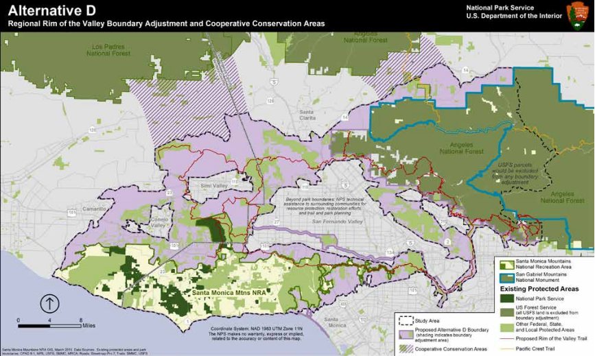
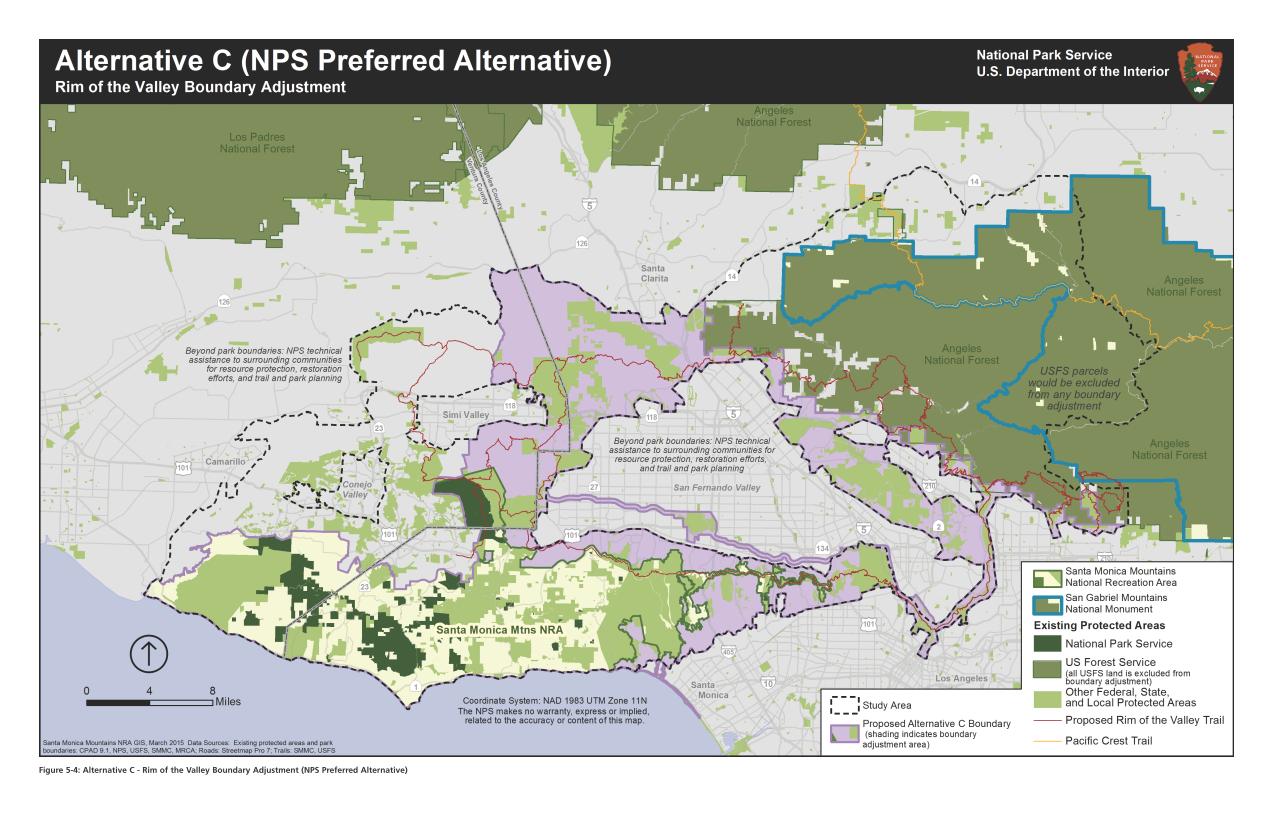
San Gabriel Mountains National Monument Management Plan Comments

Tuesday, August 11th, 2015

need to changeToday, August 11, 2015, CORBA and the Mount Wilson Bicycling Association (MWBA), submitted joint comments to the U.S. Forest Service on the San Gabriel Mountains National Monument Plan and Land Management Plan Amendment’s “Need to Change” Analysis.  Our comments are linked below.

As members of the San Gabriel Mountains National Monument Community Collaborative, we have also signed the consensus comments submitted by the Collaborative group, which we helped develop.

These are an important milestone in the development of a management plan for our new National Monument. The Presidential Proclamation directed the Forest Service to develop a management plan within three years. Most management plans take longer than that to develop, but the Forest Service’s approach to amend the current plan should allow them to complete the plan within the alotted time frame. We were pleased that the Forest Service extended the current comment period to allow for more thoughtful comments.

We were in general agreement with most of the findings of the “Need to Change” analysis, which stated specifically that the existing Forest Plan guidance on Recreation Management did not need to change. However, the Proclamation calls for the development of a Transportation Plan, which could impact recreational trail management. Accordingly, we commented on the need to develop a transportation plan for the entire Forest, both to improve recreational opportunities and to protect the resources of the Forest.

It is now up to the Forest Service to take into consideration all of the comments submitted, and their own analysis to develop a draft Environmental Assessment and Monument Management Plan. We expect that draft to be available for public review in spring, 2016.

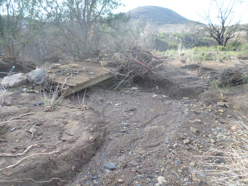
Until that time, we’ll continue to work with the Forest Service on project-level issues including trail maintenance and restoration, in accordance with our existing partnership and volunteer agreements.

Comment PDF:  2015-08-11 – CORBA and MWBA SGMNM Need to Change Comments

President declares three new National Monuments

Saturday, July 11th, 2015
Three new national monuments

Three new national monuments

Yesterday, July 10, 2015, President Obama used his powers under the Antiquities act to declare three new National Monuments.  There were another three declared in February 2015, and a further monument in December. That’s seven new National Monuments since we were given the San Gabriel Mountains National Monument on October 10, 2014.

Clearly, this President has been on a roll when it comes to land protections. All of these new National Monuments will face the similar challenges of developing management plans that protect the resources of the monuments, but also allows for recreation and enjoyment of those resources. Each has their unique characteristics and each proclamation is written specifically for each monument.

Of the most recently-declared monuments, one has no real biking opportunities. The Waco Mammoth National Monument was owned and operated as an archaeological dig site by the City of Waco, Texas. Under the new monument, the city of Waco will transfer the 108 acre site to the Federal Government, via the National Park Service, who will now coordinate with the City and with Baylor University to continue archaeological research and protect the site.

The other two, Berryessa Snow National Monument in northern California, and the Basin Range National Monument in Nevada, both include trails and mountain biking opportunities on a mix of Forest Service and BLM lands. In both proclamations, recreation opportunities are considered. The Berryessa Snow proclamation reads “…motorized and mechanized vehicle use in the monument shall be allowed only on roads and trails designated for such use, consistent with the care and management of the objects identified above.”

In the Basin Range, more than 700,000 acres of Nevada desert and mountain terrain, there are many trails. The proclamation similarly states that “…motorized vehicle use shall be permitted only on roads existing as of the date of the proclamation. Non-motorized mechanized vehicle use shall be permitted only on roads and trails designated for their use, consistent with the care and management of the objects identified above. The Secretary shall prepare a transportation plan that designates the roads and trails where motorized or non-motorized mechanized vehicle use will be permitted.”

In both of the above examples, just as in our own San Gabriel Mountains National Monument, mountain bikes will be permitted only on roads and trails authorized for their use. One difference between the two, however, is that the Basin Range proclamation also explicitly prohibits the development of new motorized vehicle routes. No such restriction is placed on non-motorized trails used for mountain bikes or “mechanized” travel, but the development of a transportation plan is where the details will be hammered out.

Similarly, our San Gabriel Mountains National Monument allows existing uses on existing trails, but also calls for the development of a transportation plan that will include trails, roads, and their respective use designations. Mountain bikers in all these areas should be thankful for the elevated protections these special places have now been given, but should also remain engaged as active trail advocates, trail stewards, and partners in the development of the management plans and transportation plans that will govern our future access to and enjoyment of these special landscapes and the trails by which we experience them.


President’s Message: It’s complicated

Thursday, July 2nd, 2015
San Gabriel Mountains National Monument Community Collaborative

San Gabriel Mountains National Monument Community Collaborative

There’s always a lot going on here in Southern California. We have recently submitted comments on the Rim of the Valley study. We’re expecting the Santa Monica Mountains NRA Interagency Trail Management Plan early next year. A new National Monument management plan development process just began, though CORBA has been involved in the Community Collaborative Group since last November. We’ve successfully alerted L.A. County of the need for another trail master plan, to be announced soon. We have pending Bike Park proposals, and a recently-opened Bike Park in Fillmore. We have a growing high school and middle school racing contingent. We have a new Forest Supervisor. There are wilderness proposals, missing links in trails, fire-damaged trails still in need of restoration, access issues on Etz Meloy (Backbone Trail). There’s no shortage of issues, threats to our public lands, our trails and access to them.

It’s complicated.

And it takes time to figure things out and try to get things right.  These studies and plans seem to disappear from the radar, only to re-emerge six months to a decade later. Advocacy is a marathon, not a sprint, and CORBA is still at it after 28 years. Government is slow to move but no matter how frustratingly slow it sometimes seems, there is progress being made.

CORBA is busily engaged in all of these processes on your behalf, in partnership with IMBA, to help make sure there is progress. We continue to work to make sure the landscapes we ride and the trails we love are protected, improved, and remain open to our community.

We need each and every one of you to be engaged as well. After all, we’re all ambassadors of the sport when we’re on multi-use trails. This means ride an appropriate speed for your sightline (slow down!) and be courteous. Be safe. Follow trail etiquette best practices. Be an example for others. Leave no trace. Support CORBA. Sign a petition. There are lots of ways to have a positive impact.

Riding trails to explore our public lands is a passion we all share, and want to continue to enjoy. Enjoy your summer and keep on riding!


Rim of the Valley Corridor Study

Tuesday, June 30th, 2015

ROTValternativeDCORBA has been involved in the Rim of the Valley Corridor since our inception. In fact, we’re so ingrained in the process that the Rim of the Valley Corridor is mentioned in our mission statement as our primary territory of concern. We were excited to see the draft study released, and have submitted comments on the plan.

The study sought to answer the following:

1. Does the area possess nationally significant natural or cultural resources?
2. Is it a suitable and unique addition to the National Park System?
3. Can it be feasibly added to the Park System?
4. Does it require direct NPS management, instead of stewardship from other groups or a public-private combination?

The answer to all of the above questions was a “yes.” The National Park Service presented four alternatives based on the study findings. The first NEPA-required “no action” alternatives serves as a baseline against which we can compare the alternatives. Alternative B allows the NPS to offer “technical assistance” to existing land managers within the study area, but falls short of allowing the NPS to make any direct capitol investments.

Alternatives C and D expand the authorized boundary of the Santa Monica Mountains National Recreation Area. What the boundary expansions really mean is that the National Park Service will be authorized to offer technical assistance to existing land managers for any project that enhances recreation, or restores habitat and connectivity. Under Alternative C or D, the NPS is also authorized to spend money on capitol projects within the expanded boundaries.

We believe that the largest operational boundary proposed under Alternative D would have the greatest long-term benefit for recreation, bio-connectivity, wildlife and the communities adjacent to the study area. It also includes the wildlife corridors linking the two areas of the Angeles National Forest separated by Highway 14, as well as between the Santa Susana Mountains and Los Padres National Forests.

The boundary expansion does not come without concern. The NPS, like most public land agencies, is currently under-funded. We would hope that any boundary expansion would come with an increase in funding sufficient to at least maintain the current level of service across the expanded NRA.

During the course of the public meetings we heard a lot of misinformation and a misunderstanding of what the boundary expansions mean. The Federal government will not be taking anyone’s property against their will. Existing land ownership rights and management authority is respected and maintained.

One thing that would change is the permitting of landfills. In our comments, we asked for the existing landfills to be excluded from the proposed NRA expansion to eliminate the need for additional permitting. We also feel that the recently completed San Gabriel Watershed and Special Resource Study which proposed a San Gabriel Unit of the NRA, must be considered and its findings also addressed by any congressional action to the effect of either.

The Rim of the Valley trail system is also important to us. It’s a proposed multi-use trail network that will encircle the San Fernando Valley, and perhaps Simi and Conejo Valleys. We feel the National Park Service will be in a good position to help facilitate its completion under Alternatives C or D.

It will probably be another year before we see a final recommendation from the study. From there it will be up to Congress to decide what to do with the recommendations.

2015-06-24 – Rim of the Valley Draft Study Comments from CORBA

Rim of the Valley Corridor Study Released

Tuesday, April 14th, 2015
The NPS Preferred Alternative

The National Park Service (NPS) today released the findings of the Rim of the Valley (ROTV) study, including a draft Environmental Impact Report and Proposed Alternatives. The study has been underway since 2010. CORBA has commented on previous phases of the study and has also encouraged our members and the mountain biking community to do so.

The NPS has developed five alternatives for the public to comment upon. Their preferred alternative expands the boundary of the Santa Monica Mountains National Recreation Area (SMMNRA) to include much of the study area, which would allow the NPS to provide technical assistance to other land managers within the NRA.  Other alternatives include a “no action” alternative, meaning that nothing will change, a Conservation Partnership alternative, and a boundary expansion plus conservation partnership alternative.  A fifth alternative, which would have only provided planning assistance for a Rim of the Valley trail, was rejected as it didn’t meet the objectives of the study.

None of the proposed alternatives would affect or include any Angeles National Forest or San Gabriel Mountains National Monument, which would remain under the management of the Forest Service. All alternatives (except the “no action” alternative) include the conceptual Rim of the Valley Trail, as originally envisioned by Marge Feinberg in her 1976 Masters thesis.

CORBA will be analyzing the study’s findings and will report back. Comments must be submitted before June 30, 2015.  An executive summary can be found here. The comprehensive set of related documents and maps, and a comment submission form can be found on the NPS Park Planning web site, while a more user-friendly overview of the process can be found at http://www.nps.gov/pwro/rimofthevalley/index.htm

The NPS is hosting six public meetings between April 21, 2015 and June 2, 2015 to discuss the findings and alternatives presented in the draft study report. We invite and encourage all CORBA members and supporters to attend one of the public meetings. For those unable to attend, we’ll post a full report after the first meeting.

Online/Virtual Public Meeting:

Tuesday, April 21, 2015 12:30 p.m.(PDT)/ 3:30 p.m.(EDT) (WebEx Connect Time)

Please check-in early as there could be some software downloads that you may need to install to participate. The meeting presentation will start promptly at 1:00 pm PDT/4:00 pm EDT.

Click here for instructions on how to participate in the online meeting.

Local Public Meetings Schedule:

Monday, May 4, 2015, 7–9 pm
La Crescenta Public Library, Community Room
2809 Foothill Blvd.
La Crescenta, CA 91214

Tuesday, May 5, 2015, 7–9 pm
William S. Hart Regional Park, Hart Hall
24151 Newhall Avenue
Newhall, CA 91321

Wednesday, May 6,2015, 7–9 pm
Conejo Recreation and Parks District
Community Room
403 West Hillcrest Dr.
Thousand Oaks, CA 91360

Thursday, May 21, 2015, 7–9 pm
Mason Recreation Center
10500 Mason Ave.
Chatsworth, CA 91311

Tuesday, June 2, 2015, 3-5 pm*
El Pueblo de Los Angeles
Hellman-Quon Building
130 Paseo de la Plaza
Los Angeles CA 90012

Action Alert: Save the Palm Canyon Epic

Wednesday, March 4th, 2015
Epic views of the Santa Rosa Mountains

Epic views of the Santa Rosa Mountains

Palm Canyon Epic (PCE) is one of the iconic long-distance rides of Southern California. It’s a spectacular point-to-point route in the Santa Rosa Mountains, south of Palm Springs and Cathedral City. It’s a place that many dedicated mountain bikers make an annual winter pilgrimage to ride.

Though it’s outside CORBA’s territory, many CORBA members and supporters ride the trail. The BLM has completed an environmental document for a land swap with the Agua Caliente band of Cahuila Indians. When the land was parceled out in the 1800’s, it was done in a checkerboard fashion. Alternating lots were deeded to the Indian tribe and to the U.S. government through the BLM. The land swap is an attempt to consolidate ownership of contiguous properties so the land can be more easily managed.

While the tribe’s stewardship of their lands has been positive, the tribe doesn’t allow bicycles on trails.  They charge a fee for hikers and equestrians. In the land swap, portions of the Palm Canyon trail, and many other trails important to the local communities, would become tribal land. Though the tribe have stated they would keep the trail open, there is nothing in this environmental document requiring them to do so. They’ve already posted “no bikes” signs on the Indian Potrero trail, which crosses tribal land for a short distance, and is a part of the classic PCE.

Now is the time to make your voice heard and write to the BLM. We believe it is in everyone’s best interest to keep these trails within public ownership (BLM). Scenario 1 is our preferred option, which keeps the trails with the BLM. Our colleagues at the San Diego Mountain Bike Association provide more background information and have drafted a letter that you can cut and paste. You can find their letter here. Comments must be received by March 29th, 2015!

IMG_20141222_080605

Beautiful and challenging

Whether you’ve already ridden it and love it, or would like to be able to do so in the future, do it now!  It will only take a minute or two of your time, and every letter or email sent counts.

A classic long-distance desert ride

A classic long-distance desert ride

If you’re not familiar with this epic rides, you can watch a couple of Palm Canyon mountain biking videos.


Scouting the trails of newly re-opened Pt Mugu State Park

Wednesday, February 4th, 2015

Here is what I found when I rode all the multi-use trails a few days after Pt Mugu State Park re-opened on January 30th. The park had been closed since mid-December when heavy rains brought mudslides to the fire-denuded park. During the closure, heavy equipment was used to clear up the extensive damage on the fire roads, and small groups of volunteers were fixing some bad spots on singletrack trails, using hand tools. In fact, volunteer groups will be converging on the park throughout February to help fix the trails. You can help! Here’s the schedule: 2015-01-22 PMSP Trailwork Schedule.

My first impression was that there were a lot of people in the park for a Tuesday morning. No doubt they were as curious about its condition as I was. (There are a number of photos below that show a typical condition, and a much larger photo gallery to show more trail problems, large and small.) One pleasant surprise was that the wildflowers are coming out, in abundance in some places. I’ve included pictures of some of them in the photo gallery.

I entered the park from the north end, through Rancho Sierra Vista/Satwiwa. There are signs posted at the entrance to Pt Mugu State Park (PMSP) indicating that you can’t get through to the coast, and that there is no water in the park.

On the main Sycamore Canyon Fireroad, there were numerous shallow mudslides that had come down the hill and crossed the road. Some were narrow and others were quite wide. All of them had been cleaned up. The whole road was smooth and quite broad. Unfortunately, I wasn’t able to make it to the campground because the road was closed south of the point where Overlook Fireroad comes into it.

Piles of dirt that were removed from the main Sycamore Canyon Fireroad.

Sin Nombre and Two Foxes Trails had had lots of tiny mudflows across them, leaving small ridges perpendicular to the trail. They make for a bit of a bumpy ride. There were several ruts in the hillside above and below the trail where a small stream crossed, but did very little or no damage to the trail. There were a few spots where larger streams did damage the trail, leaving ruts and/or rocks and dirt.

A small stream crossed Sin Nombre but did little damage to the trail.

On the Wood Canyon Vista Trail, a segment of the Backbone Trail, there were five notable kinds of features on the trail. Most noticeable was the lack of serviceable drainage dips. Of the 84 drains we installed after the Springs Fire in 2013, almost all were choked with debris, and many couldn’t even be distinguished from the rest of the trail. Large stretches of trail had mud and water flowing across it, leaving small ridges perpendicular to the trail. Other large stretches had water running down the trail, removing all the dirt and sand, leaving a very rocky surface. The clay stretch about 2/3 of the way up has become deeply trenched and rutted. Finally, some trailwork has already been done, and there the surface was generally smoother and outsloped, but slightly loose.

Water running down the Wood Canyon Vista Trail has removed most of the dirt, leaving a lot of exposed rocks.

Climbing the old ranch road section of Guadalasca, I saw a lot of damage. However, it was mostly easy to avoid because the trail there follows an old wide roadbed. The top 20% of the singletrack downhill, where we had worked after the Springs Fire, was in very good shape. However, it was a different story for the rest, where it had already been quite rutted. Most of it was only slightly worse, but the worst sections were much worse than they had been. You can avoid the ruts now by using the very edge of the trail, but that won’t be an option once the vegetation grows up again. In the two places where the trail crossed a small stream with a culvert under the trail, the culvert had become blocked and the upstream streambed was completely filled with silt, while below the trail, the streambed was scoured down to bare rocks. The trail crossing the stream had acted as a dam and held back the dirt and rocks that were washing downstream. Finally, the lower old ranch road section had also become much more rutted, and the culverts under the trail had become exposed.

A really bad section on Guadalasca

During the Santa Monica Mountains Trail Day in April 2014, a large group of volunteers essentially rebuilt the Sage Trail. After the December flooding, the trail remains mostly intact, but we were very lucky that it wasn’t annihilated. The trail runs near the outside edge of an old roadbed. For most of it’s length, water and mud streamed down between the trail and the hillside creating a wide trench, crossing the trail occasionally and flowing off the edge. Most of the armoring rock walls we built to protect previous washouts were intact, but the water flowed around them to enlarge the washouts, generally on the downhill side. Two of the armoring walls didn’t fare well at all.

The next heavy rain may obliterate sections of the Sage Trail if the rut gets much wider.

Finally, here’s what you can see in one spot at the side of the Wood Canyon Vista Trail.

California Poppies at the side of the Wood Canyon Vista Trail

Don’t forget, you can help restore the trails! Here’s the schedule for volunteer work days: 2015-01-22 PMSP Trailwork Schedule.

Pt. Mugu SP Closure Update

Monday, January 12th, 2015

SAMSUNG CAMERA PICTURESAs reported earlier this month, Point Mugu State Park has been closed to the public while the damage to the trails is being assessed and repaired. Heavy equipment has been working to reestablish Sycamore Canyon and the public is still being asked to stay out of the park until such time as it is safe. Trucks will be bringing in dirt from the slides that covered Pacific Coast Highway to aid in repair. State Parks’ Angeles District Superintendent Craig Sap stated that the closure will extend until February 1, but that all attempts will be made to lift the closure sooner if possible.

Click here to see additional photos by Craig Sap of the mud slides effecting PCH and Point Mugu State Park.

Below is current trail damage assessment of the condition of the trails in Point Mugu State Park:

Blue Canyon Trail: Fair

Chumash Trail: Good

Chamberlain Trail: Excellent

Coastal Trail: Gone

Coyote Trail: Lower portion covered with debris

Fire Line Trail: Unknown

Fossil Trail: Poor condition

Great Dune View Trail: Good

Guadalasca Trail: Fair

Hidden Pond Connector Trail: Good

Hidden Pond Trail: 25% of repairs Complete

La Jolla Canyon Trail: Devastated

La Jolla Valley Loop Trail:  75% of repairs complete

La Jolla Valley Connector Trail: Fair

La Jolla Pond Trail: Cleared

Mugu Peak Loop Trail: Debris across trail needs to be smoothed out

Mugu Peak Spur Trail: Good

Old Boney Trail: Fair from Sycamore to Blue Canyon

Old Cabin Trail: Poor

Ray Miller Trail: 25% of repairs complete

 Sage Trail: Excellent

Scenic Trail: Fair

Serrano Canyon Trail: Good

Serrano Valley Loop Trail: Minor erosion

Serrano Valley Trail: Old Roadbed from gate has several large washouts, all stream crossings need rebuilding

Sin Nombre Trail: Fair

Sycamore Creek Trail: Heavy Damage to Stairs and Gabions                                 

Tri Peaks Trail: Unknown

Two Foxes Trail: Debris flows across the trail at the drainage crossings

Upper Sycamore Trail: Devastated

 Waterfall Trail: Good

Wood Canyon Vista Trail: Good