Archive for the ‘Advocacy’ Category

L.A. Bike Plan – February Update

Tuesday, January 26th, 2010
LA Bike Plan Report – February 2009
Sadly, several City statutes make it illegal to ride on a trail in any Los Angeles City Park. After more than 18 months of development, Los Angeles’ Draft Bicycle Plan did nothing to change that. It took recommendations off the table that had been included in the plan’s last revision in 1996. It called for studies to assess our needs for trail access, but provided little in the way of concrete guidance on the issue.
The plan has been the subject of intense scrutiny from all facets of cycling, including its off-road components. When the draft document was released in late September, the City held five public workshops, and allowed just six weeks to digest and comment upon this 563 page document. Bowing to pressure from the cycling community at large, the City extended it’s comment period until January 8, 2010.
CORBA representatives attended all of the public workshops. The extended comment period gave us the opportunity to review the plan in detail, and compile our official response. We then called upon the mountain biking community at large, and you responded.
CORBA put together a grass-roots advocacy campaign, with a petition drive and an email and letter-writing drive. Between December 19, 2009 and January 7, 2010, 929 letters and signatures from mountain bikers were gathered.
On January 8 we delivered those letters to the City of L.A. Planning Department. Key City officials, Rec and Parks personnel and Members of L.A. City Council also received copies of all the  letters and petitions via email. We got the City’s attention.
This was the biggest response CORBA has ever received to an advocacy campaign. Mountain Bikers stood up for themselves, demanding a change to the decades old ban on bicycles in City Parks. We need more options for outdoor recreation and exercise, especially for kids.
Currently, the City is revising the draft plan, taking into consideration all of the comments received. A second draft is expected to be released within the next two months, and will be followed by another comment period before being submitted to the City Council for adoption. We’ll keep you informed and updated on the progress.
CORBA is looking forward to working with the City to make its parks more inclusive of all user groups, including off-road cyclists. Thank you for standing up for yourselves!

Sadly, several City statutes make it illegal to ride on a trail in any Los Angeles City Park. After more than 18 months of development, Los Angeles’ Draft Bicycle Plan did nothing to change that. It took recommendations off the table that had been included in the plan’s last revision in 1996. It called for studies to assess our needs for trail access, but provided little in the way of concrete guidance on the issue.

The plan has been the subject of intense scrutiny from all facets of cycling, including its off-road components. When the draft document was released in late September, the City held five public workshops, and allowed just six weeks to digest and comment upon this 563 page document. Bowing to pressure from the cycling community at large, the City extended it’s comment period until January 8, 2010.

CORBA representatives attended all of the public workshops. The extended comment period gave us the opportunity to review the plan in detail, and compile our official response. We then called upon the mountain biking community at large, and you responded.

CORBA put together a grass-roots advocacy campaign, with a petition drive and an email and letter-writing drive. Between December 19, 2009 and January 7, 2010, 929 letters and signatures from mountain bikers were gathered.

On January 8 we delivered those letters to the City of L.A. Planning Department. Key City officials, Rec and Parks personnel and Members of L.A. City Council also received copies of all the  letters and petitions via email. We got the City’s attention.

This was the biggest response CORBA has ever received to an advocacy campaign. Mountain Bikers stood up for themselves, demanding a change to the decades old ban on bicycles in City Parks. We need more options for outdoor recreation and exercise, especially for kids.

Currently, the City is revising the draft plan, taking into consideration all of the comments received. A second draft is expected to be released within the next two months, and will be followed by another comment period before being submitted to the City Council for adoption. We’ll keep you informed and updated on the progress.

CORBA is looking forward to working with the City to make its parks more inclusive of all user groups, including off-road cyclists. Thank you for standing up for yourselves!

Sullivan Canyon reopens November 6th

Thursday, November 5th, 2009

from Sharon O’Rourke, Public Affairs Manager, The Gas Company

The Gas Company is pleased to announce it is completing the first phase of it’s planned work in Sullivan Canyon by Friday, November 6, 2009.  The maintenance road has been re-established and 10 pipeline exposures have been covered with protective revetment mats.  The maintenance road now has the articulated concrete mats (revetment mats) in a few areas of the roadway to provide protection and covering for the pipelines.  The public should exercise caution when crossing these areas with the revetment mats.  By November 6th, the construction equipment and vehicles will be removed as well as ending the guard service.Minor work to hydro-seed vegetation in certain areas will start the week of November 16th and last for approximately 2 weeks.  This work will be during weekdays only from 8am – 5pm.  The canyon will remain open to the public while this work is proceeding as cones will be placed and signage will be posted as a safety precaution due to the presence of vehicles and to protect the newly seeded areas.  Occasionally a water truck may be used to water these areas to help the growth of the new plantings.

We want to thank the public for its patience and courtesy while we worked to ensure the safe operation of our pipelines.  The second phase of our project will start next year approximately in the spring to cover the remaining pipeline exposure areas and to finish the planting of vegetation and the sycamore seedlings.

We also wanted to share with you that our security guard, stationed at the northern end of the canyon, observed a small brush fire off of dirt road Mulholland on Friday, Oct. 31st at approximately 11 p.m.  The fire was caused by a mylar balloon (silver metallic balloon) that was loose and touched the power line, creating sparks that set off a small brush fire.  Our guard called 9-1-1 to report the fire which brought an immediate response from the Los Angeles Fire Department’s air and land crews.  The fire was limited to 1/2 acre. We are thankful that this guard was diligent, alert and responded quickly by calling in the Fire Department.

Report on the San Gabriel Watershed and Mountains Special Resources Study

Thursday, September 3rd, 2009

by Steve Messer 

Last night Hans Keifer, Steve Messer and Jim Hasenauer attended the public comment meeting put on by the National Park Service in Santa Clarita. The following is a summary of the presentation and our thoughts, concerns and feedback on the study. 

History:  

This study was mandated by Congress through a bill introduced by Hilda Solis back in about 2002 and passed in 2003. The study began in 2005, but this is the first much of the public has heard of the process, including me and other CORBA and IMBA volunteers. The study area includes much of the San Gabriel mountains, as well as the San Gabriel Watershed. The watershed includes the San Gabriel River drainage area within the national forest, as well as cities along the river and its watershed such as El Monte, Hacienda Heights, La Habra, Brea, Walnut, West Covina, Baldwin Park, Monrovia, La Verne,  and the Puente-Chino Hills area. See more on the study and the process

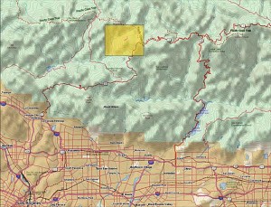
Study Area:   (See map to right) 

The goal of the first stage of the study was to determine:  

1. the “Significance” in biological, historical and recreational terms, of the study area.   

 2. the “Suitability” of the area for inclusion in the National Park system. That’s to say that it fills a gap in the National Park system that can’t be filled by anything else… ie. its uniqueness.   

 3. The “Feasibility” of bringing it into the National Park system in some manner.   

So far the study has found that there is Significance worthy of national park protection. The mountains, the biodiversity, the unique geological character, architecture and history all make it significant. 

There is “Suitability” in that there is nothing else quite like it already within the National Park System. 

It was deemed to be infeasible to make any of the study area a National Park. There are too many land owners and land managers, too many private holdings even within the National Forest, and in many respects, would be re-inventing the wheel to start from scratch with what the Forest service has already accomplished in managing the forest. 

However, it would be feasible for the National Parks service to come in and participate in the management and development of the area, in collaboration with the Forest Service and other land managers in the study area. 

Of particular concern to us, as mountain bikers, is the continued access to the trails to which we have access, the possibility of new trails being built, and to avoid any further wilderness designations. 

The final goal of the study is to present to congress a report on the Significance, Suitability and Feasibility of the area, and make a final recommendation as to the most effective and efficient way for the NPS to be involved in the management of the San Gabriel Mountains and San Gabriel River watershed. 

What is not covered at this stage of the study is what happens after the study is complete.  

 Once the final recommendation is made, it would then be up to congress to decide what to do with the recommendation. Of particular note is that Hilda Solis is now Labor Secretary, and is no longer involved in the committee that would be receiving the results of the study she helped start. The recommendation may linger on a shelf and never be implemented, or it may get picked up, brought to committee, a further recommendation made to the full house, and then may or may not pass. 

This introduces some concerns. Alternative A and Alternative C both have the largest federal presence, and both would require an act of Congress to implement. Whenever an act of congress is proposed, it will be debated and most likely amended. Amendments may introduce language to weaken our position as mountain bikers, to introduce more wilderness legislation, or to to pander to certain special interest groups with large lobbying powers. It opens the door for a whole range of uncertainties in the implementation of the plan. 

But that scenario would be a long way off. The study is still (four years along) at a very preliminary stage. They expect to have the draft proposal ready in a year, another round of public meetings and comments, and present their findings to congress in 2011. 

Several times during the presentation and the Q&A group sessions, it was expressed that the NPS would continue to allow the Forest Service to manage the forest, and other land managers would continue to manage their own jurisdictions. From our point of view as mountain bikers, this seems good policy, since the Forest Service has just spent five years or so developing the Forest Management Plan <http://www.fs.fed.us/r5/angeles/projects/ForestPlan.shtml> in which the most productive use of the forest was deemed to be Recreation. It sounded like the Forest Service would be able to continue to implement that plan, which is not at odds with the concept of a “National Recreation Area.” 

Jim, Hans, and myself split up and each joined a different discussion group. Nowhere was there any strong or vocal anti-mountain bike sentiment, and in Jim’s group four of the fifteen people were mountain bikers. My group were all hikers from Santa Clarita who wanted more trails and access from the northern slopes of the San Gabriels, which are greatly under-utilized in comparison to the more populated southern slopes. There was no equestrian presence, but a few in my group said that the equestrians were supportive and would be doing a letter writing campaign. Given the past positions of the Equestrian Trails, Inc. (ETI), their campaign will likely be very anti-mountain bike. 

But this meeting wasn’t really about what people wanted more or less of (trails, signage, interpretive centers, etc) though that is what came up most in the group discussions. It was about how the forest and watershed would be managed, and the alternate proposals for how that partnership would function. Management includes the ability to meet the needs and provide the resources that the public want, something that just isn’t presently happening given the current financial situation of the FS. 85% of their budget presently goes to fire management (well spent at the moment) leaving little for improvements.

To summarize the three alternative plans:


Alternative A
, the forest would get the largest involvement by the NPS, the largest land area that would be covered (most of the Lower Angeles National Forest) and management would come mostly from the National Forest Service with assistance, input, and funding from the NPS. This seems to us, as the better option, with less agencies involved, more land area, and more funding. It incorporates most of the Southern Angeles National Forest, and little outside the forest.  


Alternative B would have the NPS creating a Master Plan for the whole area, San Gabriel mountains, rivers, all of the cities and land managers along the river and into the Chino hills. After that master plan is developed, the NPS would have little involvement, and it would be up to each individual jurisdiction to implement that master plan as a the San Gabriels Parks and Open Space Network. It includes the southern Slopes and the San Gabriel mountains and the river corridors.  
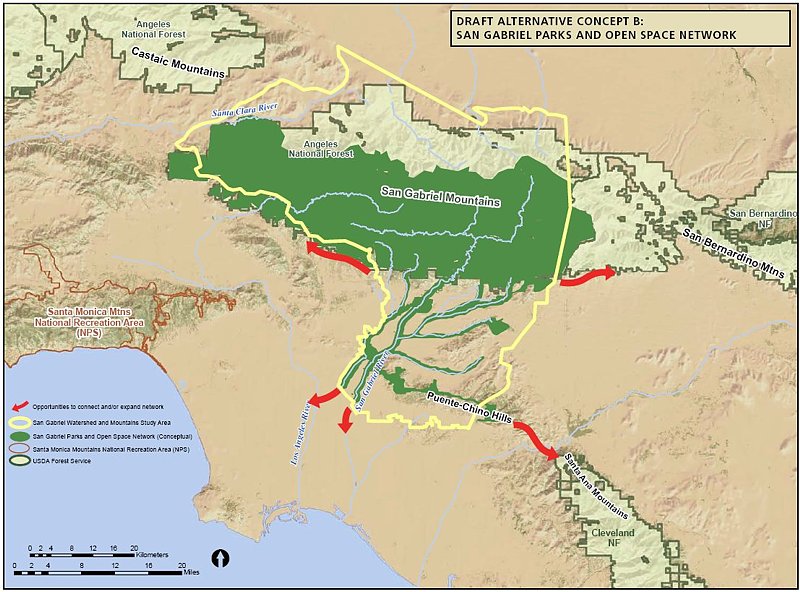
 

Alternative C would have the NPS taking a leadership role and overseeing a partnership between the FS and the many local land managers. The area would include only the San Gabriel watershed and river corridor. This would exclude most of the current southern Angeles National forest.  


There was no mention of new wilderness areas, as this is strictly a study for inclusion in a National recreation area, or Recreational Open Space area, not a wilderness study. Not much was addressed among the group discussions about the lower watershed, including the various cities and the Chino-Puente hills area, though the meetings in El Monte and Diamond bar would have had more involvement in those areas. 

There is a comment period on the current presentation through October 30th. At the above web site, click on “Newsletter 4” then click on the “Comment on Document” link on the left side of the screen. 

They need to hear from as many mountain bikers as possible, to ensure that we are represented as a large and growing user group of the forest. To make comments, here’s my list of my answers and talking points: 

NPS Public Comment Topic Questions: 

1. Is there one alternative concept or idea presented that you think is most valuable in terms of improving recreational opportunities and protecting significant resources? Tell us why you think this idea is valuable. 

The inclusion of the largest land area, Alternative A, would give the most coverage and likely bring the most resources in to manage the national forest.   A combination of Alternatives A & C would provide the most coverage of important natural resources, including both mountain and river protections and opportunities for interpretation.  A combination of A & C would create a strong federal management partnership between the USFS and NPS and a strong recreational identity for the San Gabriel Mountains and watershed.
2. What suggestion do you have for strengthening or improving on the alternative concepts? Do you have an entirely different vision of how the area should be managed? If so, please describe your vision. 

However, the inclusion of the lower watershed portions of Alternatives B and C, which incorporates much of the green belts along the rivers and the Chino-Puente hills, would present the most recreational opportunities to the largest number people. Perhaps some hybrid of these proposals in which the NPS and USFS manage the San Gabriel Mountains portion, and together oversee the partnership outlined in Alternative C as an open space network.   

3. What concerns do you have about the current alternatives? 

Recreation. The most productive use of the forest should continue to be recreation, as outlined in the current Forest Plan, and recreational access should be increased through a more streamlined process for getting new recreational projects approved. Recreational projects should be given administrative and considerational priority over commercial and other proposals, since the most productive and valuable use of the forest has been deemed recreational. We would hope that the NPS could bring in additional staff to more rapidly complete studies required by the NEPA process. These goals would seem to be in line with a National “Recreation” area. 

Mountain bike access. There is a strong need for an area for mountain bike specific trails for this fast growing user group, both to take pressure off existing multi-use trails and minimize disparate user group conflicts. However, this should not be at the expense of continued access to the existing trail network, which are currently enjoyed by many thousands of mountain bikers annually with few conflicts. A mountain-bike specific area or trail network would serve a subset of the mountain bike community whose major preference is technical downhill riding, and whose need has been demonstrated by the continued construction of illegal trails that meet that need within the region. This would remain under Forest Service management within the proposal, and no NPS policy should preclude the fulfilling of this recognized need. 

Protection. Wilderness designations should be actively discouraged from any recommendation, legislation or amendments to legislation, as such designations do not meet the requirements for the best recreational use or protection of wild areas. Other protections are available that allow better management and access to wild areas without compromising biological protection. Other political and user groups are seeing this study and proposal as a way to slip in more wilderness designations. This is contrary to the recreational nature of the forest and not in the best interest of the public as a whole. 

Management. The Forest Service should be allowed to continue to implement its Forest Master Plan, albeit with additional resources and funding provided by the NPS within their shared goals and objectives. They have already invested years of study into the area, and have developed a master plan that at present provides the best guideline for the management and further development of the forest. 

4. What are your thoughts or comments on the study findings (significance, suitability or feasibility)? 

There is no doubt among any who have hiked, mountain biked, soared (hang gliders), ridden horses, off-highway vehicles, rock climbed, or done any geological, biological  or archaeological study, that the area is significant, unique, and worthy of including in the NPS system. 

The biggest concern then becomes the addition of an additional layer of bureaucracy when trying to make improvements in access, recreational opportunities or facilities. Based on information in the presentation, those concerns appear to be minimized in the present proposals. The political manipulation of legislation that may be introduced as a result of the study favoring one user group over another, or one type of biological protection over another, then becomes the major future consideration, and that is largely beyond the scope of the present study. 

Summary and Future: 

 There is nothing presently in the study that would threaten mountain bike access to the Naitonal Forest. In fact, all indications are that the increased funding and NPS administrative assistance, as Alternatives A and C would provide, would be beneficial to all forest user groups. Perhaps some hybrid of the alternatives would be best. The NPS will hopefully determine that from the comments and meetings.

At present, we should keep monitoring the web site <http://www.nps.gov/pwro/sangabriel> for changes and updates. The newsletters (Currently number 4) outline the progress of the study and explain each of the currently proposed alternatives in detail, including the vision, concept, management structure and funding. 

Post your comments to the NPS web site as mentioned previously, and feel free to use what has been provided above or to elaborate or put your own thoughts into words. 

The next round of public meetings will take place once the draft proposal is ready (Q4 2010), and we’ll have the opportunity to make our voices heard again then.

Sullivan Canyon Closure

Friday, August 28th, 2009

A community meeting is scheduled for Monday, August 31 at 7pm at the WLA Municipal Center (1645 Corinth Ave, LA 90025) arranged by the Brentwood Community Council and Councilmember Rosendahl’s staff.  Southern California Gas Company representatives will explain their project in greater detail and provide attendees an opportunity to ask their questions. The gas company still plans to close their canyon property to the public beginning September 1, 2009 and expect to re-open the canyon when the work is complete.

Sullivan Canyon Alert!

Saturday, August 22nd, 2009

From Michael R. Leslie, Director, Brentwood Hills Homeowners Association (with edits by CORBA)

Starting September 1, 2009, Sullivan Canyon will be closed while Southern California Gas rebuilds their road and reinforces the high-pressure gas pipeline. The length of the project and closure is uncertain, but it will last at least through October.

Many of us in the community who hike, ride horses, and bike in Sullivan Canyon in Brentwood know that this canyon is a unique natural resource, with its huge oak and sycamore trees, pretty stream and wildlife.  Because of its beauty, shady paths and easy access, Sullivan Canyon gets regular and constant use by kids, adults and senior citizens from all over West Los Angeles, the San Fernando Valley, and beyond.

Resources

Yet, without any meaningful CEQA review or public notice to the community, the Southern California Gas Company plans to rebuild the road and reinforce the pipeline, starting September 1, 2009 and continuing at least 6 weeks. The canyon will be closed to public acces during this time. This project will have the following environmental impacts:

  • Cut, prune and otherwise impact 185 protected trees, including the removal of 31 sycamore trees “up to 50 inches in diameter and 95 feet in height”;
  • Grade a 12 foot wide road with wider turn-outs all the way up Sullivan Canyon from Queensferry to Mulholland;
  • Import 3100 cubic yards of fill and use 2100 cubic yards of in-situ cut material for the road bed;
  • Use articulated concrete mats and ungrouted rip-rap on 22 pipeline exposures and “backfill” 15 eroded sections on the road where it intersects the main stream and intermittent side streams;
  • Involve at least three excavations of 40 feet long by 15 feet wide at various depths;
  • Involve extensive brush cutting and vegetation removal, including the application of herbicides, all along the road construction and pipelines;
  • The road construction, brush clearance and tree cutting will be done first, starting September 1, 2009.

There was no meaningful review of this project under the California Environmental Quality Act (CEQA). The Gas Company claims it is entitled to a categorical exemption from CEQA review because the project is only a repair and maintenance project, with negligible or no expansion of use.  Yet the many admitted irreversible environmental impacts make clear this exemption is inapplicable.  Furthermore, the Gas Company did not notify our local homeowners’ groups or the Brentwood Community Council that it was seeking permits to conduct this project, despite the fact that many of us either live immediately adjacent to Sullivan Canyon or frequently hike, bike and ride there.

Please read the attached excerpts of the various project documents.  We were only able to obtain these documents after making Public Records Act Requests to the various agencies.  By the time we were able to obtain these documents, the Gas Company contended that it already has the requisite permits for the work.  Their plan was to notify the community only after all permits were issued and the work is ready to be commenced.

Update: A community meeting will be held on Monday, August 31 at 7:00 pm. At this meeting, the Gas Company will explain the project and address questions from the public. Details.

Our only hope to have any time to review and understand this project before the bulldozers and chainsaws are unleashed in Sullivan Canyon–and our only chance to have any meaningful input into mitigating the serious environmental impacts of this project–is for all of us to immediately write, email and call the offices of Councilman Bill Rosendahl, Assemblyman Mike Feuer, Senator Fran Pavley, the California Department of Fish & Game, the Regional Water Quality Control Board and the Gas Company.

We are including contact information and email addresses below for your convenience.
?
Nobody opposes the Gas Company’s efforts to properly maintain and ensure their pipelines are safe, but we are very frustrated that they just ignored the community and only planned to notify us only after the permits were issued and the project was underway. ?
?
The Gas Company should welcome reasoned community input, not be afraid of it.  They should agree to pause the project, hold a community meeting, and take advantage of the opportunity to educate and involve the many smart and committed people in the community, including the Brentwood Community Council, the many homeowner associations whose members will be affected, and interested environmental groups.

Please ask the Gas Company and your public officials to suspend the project and meaningfully consult with the community BEFORE they start work.  Once they start work, the trees will be gone and it will be too late.
?
Here is the contact information:

Councilman Bill Rosendahl
1645 Corinth Avenue
Room 201
West L.A., CA 90025
(310) 575-8461?
Fax:  (310) 575-8305

Councilman.Rosendahl@lacity.org
norman.kulla@lacity.org
California Department of Fish & Game
Jamie Jackson, Staff Environmental Scientist
Streambed Alteration Team
4949 Viewridge Ave.
San Diego, CA 92123
(626) 296-3430
jjackson@dfg.ca.gov

California Regional Water Quality Control Board

Valerie Carrillo
320 W. 4th Street, Suite 200
Los Angeles, CA
(213) 576-6600
Fax:  (213) 576-6640
vcarrillo@waterboards.ca.gov
Southern California Gas Company
Deanna Haines
Sharon O’Rourke
9400 Oakdale Avenue, SC9314
Chatsworth, CA 91311-6511
(310) 578-2669
So’rourke@semprautilities.com

OTHER IMPORTANT PUBLIC OFFICALS TO CONTACT:

Assemblyman Mike Feuer
9200 Sunset Boulevard, PH 15
West Hollywood, CA 90069
Tel: (310) 285-5490
Fax: (310) 285-5499
ellen.isaacs@asm.ca.gov

Senator Fran Pavley
2716 Ocean Park Blvd.
Suite 3088
Santa Monica, CA 90405
(310) 314-5214
Fax: (310) 314-5263

Supervisor Zev Yaroslavsky
821 Kenneth Hahn Hall of Administration?
500 West Temple Street?
Los Angeles, CA 90012?
(213) 974-3333?
(213) 625-7360 fax
zev@bos.lacounty.gov


Thanks for your prompt action!  Please circulate this news to your action networks and interested people.

Mt Lowe Truck Trail Closure

Friday, June 19th, 2009

Due to a recent rock slide, the section of the Mt. Lowe Truck Trail (Forset Trail No. 2N50) is closed from its intersection with Eaton Saddle, continuing west 1/2 mile to its intersection with Markham Saddle as shown in the picture. The trail was closed starting on June 9th and the closure is in effect until June 8, 2010.

A 150 foot portion of the Mt. Lowe Truck Trail collapsed during a rock slide making it dangerous for public access. The rock slide has created a narrow section requiring trail users to traverse on a narrow section with loose gravel and soil. The remainder of the trail will remain open with signs posted at the beginning and end of the trail in addition to signs at the actual slide area.

New Trail Approved for the Angeles National Forest – Mt. Hillyer

Saturday, May 17th, 2008

Representatives of the Concerned Off-Road Bicyclists Association (CORBA) have received approval from the the Angeles National Forest Service on a proposal for a new trail in the Chilao/Mt. Hillyer area—already a popular destination for mountain bikers, hikers and rock-climbers. Both the Forest Service and CORBA recognize that this trail helps to meet a growing demand within the community of trail users, especially mountain bikers.

The new trail, officially named “Mt. Hillyer Rock & Rail Trail”, will be approximately 1 mile long, running from near the summit of Mt. Hillyer northward to near the junction of the Santa Clara Divide Road 3N17 and the existing Mt. Hillyer Trail 11W27. The new trail will make it easy to do loops of the trail and to “session” trail features.

CORBA’s trail designers had their thinking caps on—their new trail proposal included mountain bike specific features such as log rides, bermed turns, boulder gardens, granite slick-rock, teeter-totters, log bridges, drops and jumps. The Mt. Hillyer Rock & Rail Trail is designated as multi-use, and signs will indicate advanced or difficult lines, intermediate options, and alternative bypasses for beginners and other trail users.

CORBA will need to raise approximately $82,000 in grants and donations to fund the project. CORBA has committed $6,500 from their general fund, $2,000 has been received in private donations, and a $10,000 grant was pledged by Bikes Belong. The funds will be used to purchase tools, materials, signage, machinery fuel, a kiosk and for other expenses involved in the construction. CORBA hopes to break ground on the trail in fall 2008, and be riding it by the spring of 2009.