The Draft Santa Susana Mountains Trails Master Plan and Initial Study/Proposed Mitigated Negative Declaration are available for public review beginning today (November 2, 2017) at http://www. santasusanatrailsplan.org/
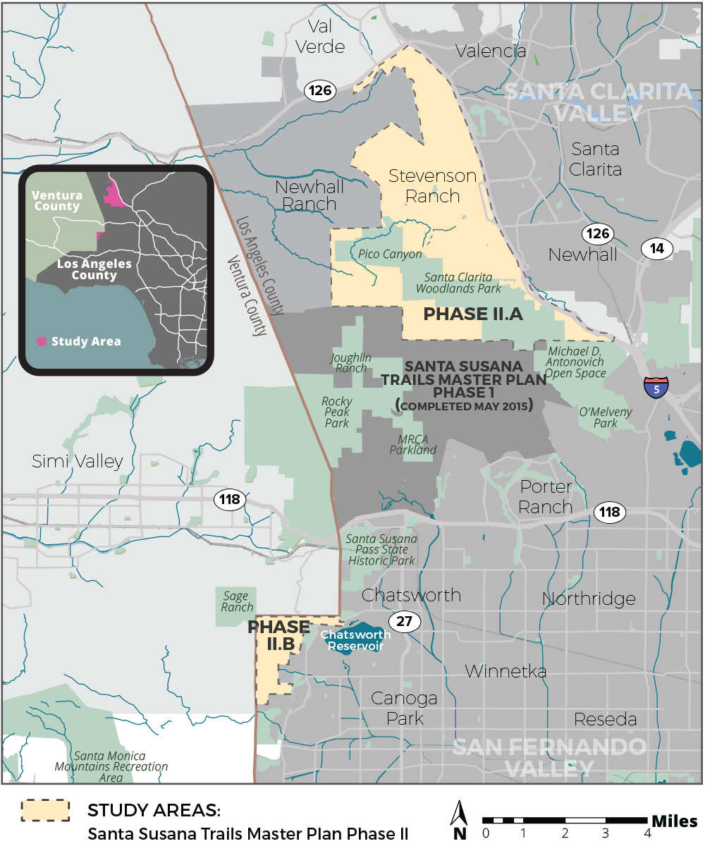
Project Location: The SSMTMP-PII area encompasses approximately 24 square miles in the unincorporated territory of the northwestern portion of the County of Los Angeles, immediately east of the boundary with Ventura County, located entirely within the 5th Supervisorial District. The SSMTMP-PII area is comprised of an approximately 22-square-mile area located in the north-facing slopes of the Santa Susana Mountains and the Santa Clarita Valley (Phase II.a) and an approximately 2-square-mile area located in the foothills of the Santa Monica Mountains, including Bell Canyon, Dayton Canyon, and Woolsey Canyon, west of the San Fernando Valley (Phase II.b). The Phase II.a area is composed of generally mountainous and valley terrain that abuts Henry Mayo Drive (State Route [SR] 126) to the north, the Interstate-5 freeway to the east, the southern edge of the Santa Clarita Valley Area Plan area to the south, and the Newhall Ranch Specific Plan Area to the west. Similarly, Phase II.b area, is composed of generally mountainous and valley terrain that abuts Ventura County to the north and west and the City of Los Angeles to the east and south.
Project Description:
The proposed project includes approximately 70 miles of proposed multi-use (hiking, mountain biking, equestrian) trails and related staging areas, bike skills parks, parking areas, and other supporting trail facilities in the Santa Clarita Valley Planning Area and San Fernando Valley Planning Area. The proposed trails would provide connections to parks and open spaces, a large commercial district, seven schools, numerous natural features, Six Flags Magic Mountain theme park, the proposed Rim of the Valley trail corridor alignment (RIVA), and existing trails in the Cities of Los Angeles and Santa Clarita, and in the Newhall Ranch Specific Plan area, as well as trails within other jurisdictions as identified in the Trails Master Plan. The trails would be multi-use and range from 3 to 12 feet wide based on site conditions, with adequate space for combined pedestrian, equestrian, and mountain biking use, in accordance with the County of Los Angeles Trails Manual guidelines (County Trails Manual). The proposed project would develop a complete multi-use trail system connecting user groups and local populations to desired recreation destinations and experiences, with unified transition to the trails of adjacent jurisdictions, compatibility with adjacent land uses and environmental resources, and incorporate a sustainable design consistent with the County Trails Manual. The plan would recommend conditions for improvement of unmet local recreation demands in the County’s Fifth Supervisorial District.
Comments
Written comments will be accepted via email or at the following street address:
County of Los Angeles Department of Parks and Recreation
Planning Division
Attn: Julie Yom, Park Planner
510 South Vermont Avenue, Los Angeles, California 90020
Email: jyom@parks.lacounty.gov
The public comment period will end on Saturday, December 16, 2017.
All comments must be postmarked or emailed no later than December 16, 2017.
COMMUNITY MEETINGS:
On Thursday, November 9, 2017, the County will host a community meeting to review the project and solicit information in relation to the CEQA analysis for this project.
The meeting will be held from 6:00–8:00 pm at Stevenson Ranch Library, 25950 The Old Road, Stevenson Ranch, CA 91381.
On Thursday, November 16, 2017, the County will host a community meeting to review the project and solicit information in relation to the CEQA analysis for this project.
The meeting will be held from 6:00–8:00 pm at Chatsworth Branch Library, 21052 Devonshire Street, Chatsworth, CA 91311.
Please direct any questions regarding these meetings to Zachary Likins at (213) 351-5149 or zlikins@parks.lacounty.gov.
Tags: Public Meetings, Trail Plan


