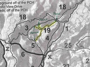
Last week we reported on the closing of the popular Art’s Trail in Pt Mugu State Park. Since then we have heard second-hand reports of more detailed reasons why the trail and its connectors were closed, namely, that there were archeologically interesting areas in the vicinity, and also sensitive plant species. Here is the response we got from Dennis Dolinar, District Maintenance Chief of the Angeles District of the California State Parks:
Good Morning !
While recently working with several people on an updated official park map for Point Mugu SP, I became aware of a set of unauthorized trails that had been developed by unknown individuals in the section of the park that roughly runs parallel to the Ranch Center Road and between the Sage and Sin Nombre Trails. These illegal routes, which likely started out as simple game trails only used by wildlife, pass through sections of the park that have never been thoroughly reviewed by our resource staff with regard to possible impacts to both natural and cultural resources. Also, the trails themselves have never been evaluated by staff regarding safe and appropriate routing through the varied terrain they cross. Subsequent conversations with our staff brought to light that there is at least one recorded culturally sensitive site in the immediate area and the entire meadows area should be further investigated . There also are as yet unconfirmed reports of unusual seasonal plant life in the area.
 The opportunity to close these unauthorized routes presented itself last month and, as the District’s Chief of Maintenance, I worked with a local boy scout troop to block-off the four obvious access points to the area in question. It is our intention to keep this area closed to all users until such time as a complete evaluation of the park’s resources can be completed. There will be no attempt to actually remove the trails themselves unless that internal review warrants it. Ultimately, these routes of travel could possibly re-open but that has yet to be determined.
Just to make sure that we are talking about the same set of unauthorized trails, I’m attaching a copy of a portion of a private party trail map that I’ve taken off the Internet. The person that produced that map identifies these routes as being Art’s Trail ( #19 ). I have also heard these same routes called by other names by park visitors.
Any support that the CORBA membership can give us to manage this situation would be greatly appreciated as we strive to protect the park, it’s resources and all our visitors.
I hope this helps you better understand the situation. Please share this information with others in your group. ===> Dennis D
Despite the above email, questions still remain surrounding this issue and CORBA will continue to pursue any and all information pertaining to this closure.
For more, see the June 25th update on this issue.


The trail has been there for about 8 years+! If there are “sensitive” plants there, they will be present in the adjoining Hidden pond trail area which follows a similar path near a creekbed. I believe this is a “psychological” problem with the new District’s Chief of Maintenance. The need to issue some kind of control over people – sick! As far as “cultural resources” go, the Chumash were nomads, so that means to me that the entire park should be off limits because the Indians could have set up camps all over the park. This is just a small group that believes that they must “nanny” us to “save the meadow”. Well good luck with all that.
This closure is utter BS. The trail has been there and in common use for over 20 years. This is not a “New” or “Planned” trail and needn’t have been closed while the Park reviews the area per CEQA requirements. The Park staff has been well aware of its existence over the years and it should have been on their Route Designation Maps from day one. If they had done their jobs properly, the trail would not be an issue today.
I have also heard claims (from Park employees) that this area is has sensitive cultural and natural resources. If this is true and the Park is aware of sensitive ‘resources’ in the area, then why did the Park allow the neighboring rancher’s cattle to trample, graze and defecate all over this exact area for over 2 months last year?