By Mark Langton
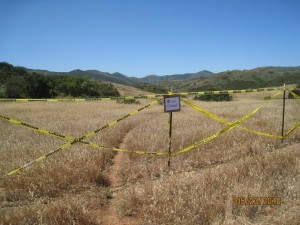
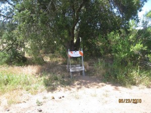
 More trails, this time in Point Mugu State Park, have been deemed unauthorized and marked with signs and fencing designating them as closed (View our earlier article on Malibu Creek State Park). One trail, known as “Art’s Trail,” connects Sage Trail and Sin Nombre, paralleling the paved road that leads to Wood Canyon. Two other shorter trails connect to the paved road farther to the west. Here is the narrative and explanation given for these actions from Dennis Dolinar, District Maintenance Chief, Angeles District, California State Parks:
Last weekend, I participated in a project with a group of local boy scouts from Newbury Park to erect a combination of both fences and barriers on the four entry points to a set of unauthorized trails that lie in the backcountry of Point Mugu SP. I had become aware of these specific trails a couple of months ago while working with others on a new official trail map for the park. After discussions with our both our Senior Environmental Scientist, Suzanne Goode, and our District Archeologist, Barbara Tejada, I decided to take the steps necessary to close this set of trails until such time as they can be fully evaluated in terms of both user safety and possible resource damage.
The trails in question are totally unofficial and, as such, they probably go by various names in the hiking, biking and equestrian communities. A private website known as Ventura County Trails uses the following names to describe the trails in question. The main segment that travels roughly parallel to Ranch Center Road from Sin Nombre Trail to Sage Trail is been labeled by them as being “Art’s Trail”. In addition, there’s two short connector trails that go up to the paved road that have been given the names “Kubler” and “Clark”. It appears quite possible to me that these routes started out as little more than game trails that skirted the large, fragile meadow but, with repeated use by those park visitors who somehow knew that they existed ( they do not appear on any official state park maps ), they have become more obvious over time. Attached you will find a location map of the closed trails.
 At this point in time, the trail entrances have been closed by use of simple barriers and fences but there are no immediate plans to destroy the trails themselves. The hope is that we can stop and/or minimize the use of this set of trails until such time as staff can evaluate the park resources that are potentially effected by these types of visitor use. Many of the people I spoke with out on the trail last weekend were disappointed but seemed to understand the need for us to manage this issue.
As time and work priorities allow, I will get back to you and your organization again as to our progress on this ongoing project.
While the above explanation is not wholly acceptable, it is within their purview to undertake these actions. What is most frustrating about the above comments is that State Parks is expending resources on projects that lack more comprehensive internal, peer, and constituent review and input. CORBA is monitoring this situation closely and will have more information as we obtain it.
(photos courtesy Dennis Dolinar)
Also, see the June 16th update on this story.


I and many others have been riding “Art’s Trail” for many years, ten or so. I do not ride at Sycamore often – but when I do, I always ride this trail – the meadow views are fabulous. It seems odd to me that someone at CSP would admit that they just became aware of these trails a few months ago – it often appears that those that manage the trails are very much out of touch with the trail systems they manage and with trail users. Closing Art’s trail, which in my experience typically is used more as a one-way trail (north-to-south, or riding towards the ocean), funnels all users onto one trail – Sin Nombre/two foxes – as I found out on Monday! Note that the Coyote Trail appeared to be open, and then subsequently closed, to bikers about five years ago – the single track options are not many…. It might have made more sense to study this issue without closing the trail, since it has been used for so many years – take the time needed to get appropriate input and assess impacts and to develop a plan and inform the user community in parallel. The cost and effort associated with the fences that were erected seem like a waste unless the long-term plan is to close the trails permanently. My comments essentially repeat what is stated in the last paragraph above. If I lived close-by and used this trail frequently, I would be very disappointed.
On another topic, I want to compliment those responsible for the Backbone (Wood Canyon Vista) Trail maintenance work that was recently completed (not something I am in the habit of doing). Although I always prefer a more natural trail (minimal trail work), this trail probably needed some work and the work done was not heavy handed. When I noted the SWECO tracks at the top of the trail, I was prepared for the worst, fortunately, my fears were not realized. The trail should soon revert to a more natural look with some use and rain. The work did leave the trail a bit too soft at the very top – let’s hope the marine layer will help tame this; overall, nicely done.
Please keep up the good work on keeping the user community informed. John Wallace
I’m a local and ride in the area more than anyone else. I can say that some of the trails were started by researchers/naturalists who trekked to their traps (low plastic barriers) by the same path day after day. I watched the progress of broken grass turning into a trail. It didn’t take long for other users to notice a “new” trail, such as a shortcut across the meadow. If you see trails that make no sense – leading into the chaparral and fading – you can be sure it’s not a recreational user.
John and Douglas,
Your comments are very much appreciated. I too think it makes very little sense to “close” a trail without much–if any–studies or internal/public review.
Mark Langton
This closure is utter BS. The trail has been there and in common use for over 20 years. This is not a “New” or “Planned” trail and needn’t have been closed while the Park reviews the area per CEQA requirements. The Park staff has been well aware of its existence over the years and it should have been on their Route Designation Maps from day one. If they had done their jobs properly, the trail would not be an issue today.
I have also heard claims (from Park employees) that this area is has sensitive cultural and natural resources. If this is true and the Park is aware of sensitive ‘resources’ in the area, then why did the Park allow the neighboring rancher’s cattle to trample, graze and defecate all over this exact area for over 2 months last year?